Springtime is when down burst potential becomes a significant severe weather concern across the Intermountain Region including Star Valley. Thus I have reposted a blog from 3 years ago about the major down burst that struck Willow Creek in 2010
Three Years Later (June 6 2010)
A map below indicates ground zero for the downburst.

Following are several photos taken on June 6th 2013, 3 years later, of the obvious evidence of the power of the winds near the A Marker.


 |
| Google Maps Image 2009- pre-blowdown |
 |
| Post-blowdown from BING maps |
 |
| Additional Post-Blowdown from BING maps |
Also a photo was taken looking north from Star Valley Ranch as the storm was moving by, which was not toward the most intense portion .

On examination of the Pocatello radar data of the storm it was undoubtedly a Supercell. While tornados are associated with Supercells, in this case there is no evidence of any tornadic circulation. The storm was moving at close to 60mph and as the following radar images of the storm will attest, it was very impressive.
The first image shows a vertical radar cross-section with a very strong and high reflectivity core to above 30,000 feet and overall storm top to above 50,000 feet as it was approaching the Wyoming/Idaho line.
 |
| Pocatello Doppler Radar 7:19 PM June 6 2010 |
 |
| Pocatello Doppler Radar 7:19 PM June 6 2010 |
The following is the Vertically Integrated Liquid(VIL) which displays the area of greatest large hail potential.
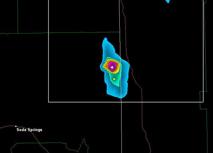 |
| Pocatello Doppler Radar VIL 7:19 PM June 6, 2010 |
 |
| Pocatello Doppler Storm Relative Velocity 7:06 PM June 6, 2010 |
While a tornado could not be ruled out with a storm of this intensity, the character of the storm and wind fall of the trees, all up-canyon, a downburst with speeds possibly to 80 mph or more was the likely culprit of the observed damage.
No comments:
Post a Comment