Snow will end in Star Valley by Friday morning with Saturday the only fair day prior to the next and even colder system that arrives on Sunday.
Riverton Forecast Office Weekly Video Briefing
A BLOG ABOUT WEATHER FORECASTING AND OBSERVING AS IT RELATES TO STAR VALLEY, WYOMING IN PARTICULAR
Thursday, October 31, 2013
Wednesday, October 30, 2013
Final Snow Totals for October 28-29
Riverton Forecast Office has issued a Final Summary on the Storm of Oct 28-29 2013

*
Tuesday, October 29, 2013
Wyoming Snow Summary for Oct 28-29
SNOWFALL REPORTS RECEIVED FROM OCTOBER 28-29 WINTER STORM THROUGH
8 PM TUESDAY EVENING...

LOCATION                             SNOWFALL
LINCOLN COUNTY...
 INDIAN CREEK SNOTEL...              14 INCHES.
 COTTONWOOD CREEK SNOTEL...          11 INCHES.
 WILLOW CREEK SNOTEL...              11 INCHES.
 SPRING CREEK DIVIDE SNOTEL...       11 INCHES.
 KELLEY RANGER STATION SNOTEL...     10 INCHES.
 SALT RIVER SUMMIT SNOTEL...         10 INCHES.
 HAMS FORK SNOTEL...                  9 INCHES.
 BLIND BULL SUMMIT...                 8 INCHES.
 COMMISSARY RIDGE...                  8 INCHES.
 10 W KEMMERER...                     5 INCHES.
 21 NNW KEMMERER...                  5 INCHES.
 TURNERVILLE...                     4.5 INCHES.
 STAR VALLEY RANCH...              4.5 INCHES.
 KEMMERER...                        4.3 INCHES.
 5 SSE SMOOT...                       4 INCHES.
 BOX Y RANCH...                       4 INCHES.
 2 SE THAYNE...                       3 INCHES.
 1 SW KEMMERER...                     3 INCHES.
 STAR VALLEY RANCH...                 3 INCHES.
 AFTON...                           2.4 INCHES.
 3 SE BEDFORD...                      2 INCHES.
 STAR VALLEY RANCH...                 1 INCH.
 ALPINE...                            1 INCH.
BIG HORN COUNTY...
 1 E GREYBULL...                      3 INCHES.
 BONE SPRINGS DIVIDE SNOTEL...        2 INCHES.
 BASIN...                             2 INCHES.
 OTTO...                            1.5 INCHES.
 SHELL CREEK SNOTEL...                1 INCH.
 BALD MOUNTAIN SNOTEL...              1 INCH.

FREMONT COUNTY...
 9.5 SW LANDER...                   8.5 INCHES.
 HOBBS PARK SNOTEL...                 8 INCHES.
 RIVERTON WEATHER OFFICE...         7.2 INCHES.
 LANDER AIRPORT...                  7.0 INCHES.
 6 SW LANDER...                     6.6 INCHES.
 5 WSW LANDER...                    6.3 INCHES.
 COLD SPRINGS SNOTEL...               6 INCHES.
 SOUTH PASS SNOTEL...                 6 INCHES.
 DEER PARK SNOTEL...                  6 INCHES.
 BROOKS LAKE LODGE...                 6 INCHES.
 ST. LAWRENCE ALT SNOTEL...           6 INCHES.
 1 W LANDER...                      5.5 INCHES.
 HUDSON...                          5.5 INCHES.
 10 NW RIVERTON...                    4 INCHES.
 RED CANYON...                        3 INCHES.
 LITTLE WARM SNOTEL...                3 INCHES.
 RIVERTON...                          3 INCHES.
 DUBOIS...                            2 INCHES.
 CASTLE CREEK SNOTEL...               1 INCH.

HOT SPRINGS COUNTY...
 OWL CREEK SNOTEL...                  4 INCHES.
 LUCERNE...                           3 INCHES.
 THERMOPOLIS...                       2 INCHES.

JOHNSON COUNTY...
 BUFFALO...                         5.1 INCHES.
 3 NNE KAYCEE...                    3.5 INCHES.
 CLOUD PEAK RESERVOIR SNOTEL...       3 INCHES.
 SOLDIER PARK SNOTEL...               3 INCHES.
 HANSEN SAWMILL SNOTEL...             3 INCHES.
 4 SSW BUFFALO...                   2.5 INCHES.
 LITTLE GOOSE SNOTEL...               2 INCHES.
 BEAR TRAP MEADOW SNOTEL...           2 INCHES.

               1 INCH.

NATRONA COUNTY...
 CASPER MOUNTAIN SNOTEL...            2 INCHES.
 GRAVE SPRING SNOTEL...               1 INCH.
 RENO HILL SNOTEL...                  1 INCH.
 POWDER RIVER SCHOOL...               1 INCH.

PARK COUNTY...
 3 NE SUNSHINE...                     2 INCHES.
 MARQUETTE SNOTEL...                  2 INCHES.
 KIRWIN SNOTEL...                     2 INCHES.
 TIMBER CREEK SNOTEL...               2 INCHES.
 PAHASKA...                           1 INCH.
 EVENING STAR SNOTEL...               1 INCH.
 BLACKWATER SNOTEL...                 1 INCH.

SUBLETTE COUNTY...
 TRIPLE PEAK SNOTEL...                8 INCHES.
 KENDALL RANGER STATION SNOTEL...     5 INCHES.
 LOOMIS PARK SNOTEL...                5 INCHES.
 SNIDER BASIN SNOTEL...               5 INCHES.
 ELKHART PARK G.S. SNOTEL...          5 INCHES.
 BIG SANDY OPENING SNOTEL...          5 INCHES.
 POCKET CREEK SNOTEL...               5 INCHES.
 8 N DANIEL...                        4 INCHES.
 NEW FORK LAKE SNOTEL...              4 INCHES.
 14 NW PINEDALE...                    2 INCHES.
 LARSEN CREEK SNOTEL...               2 INCHES.
 DANIEL FISH HATCHERY...              2 INCHES.
 GUNSITE PASS SNOTEL...               2 INCHES.
 EAST RIM DIVIDE SNOTEL...            1 INCH.

SWEETWATER COUNTY...
 GREEN RIVER...                       4 INCHES.
 FARSON...                            2 INCHES.
 5 N FARSON...                        1 INCH.

TETON COUNTY...
 PHILLIPS BENCH SNOTEL...            11 INCHES.
 JACKSON HOLE-RENDEZVOUS BOWL...     11 INCHES.
 TETON PASS...                        9 INCHES.
 JACKSON...                       7-8.5 INCHES.
 JACKSON HOLE-MID...                  8 INCHES.
 4 SSW JACKSON...                   7.5 INCHES.
 3 SSW WILSON...                    7.5 INCHES.
 GRAND TARGHEE SNOTEL...              7 INCHES.
 5 SE RAFTER J RANCH...               7 INCHES.
 TOGWOTEE PASS SNOTEL...              5 INCHES.
 12 NE JACKSON...                     4 INCHES.
 GRASSY LAKE SNOTEL...                4 INCHES.
 JACKSON HOLE-BASE...                 4 INCHES.
 MOOSE...                             3 INCHES.
 TOGWOTEE MOUNTAIN LODGE...           3 INCHES.
 BASE CAMP SNOTEL...                  3 INCHES.
 5 NW JACKSON...                      3 INCHES.
 GRANITE CREEK SNOTEL...              1 INCH.
 GROS VENTRE SUMMIT SNOTEL...         1 INCH.
 SNAKE RIVER STN SNOTEL...            1 INCH.

WASHAKIE COUNTY...
 16 SSE TEN SLEEP...                  2 INCHES.
 POWDER RIVER PASS SNOTEL...          1 INCH.
 MIDDLE POWDER SNOTEL...              1 INCH.

YELLOWSTONE NATIONAL PARK...
 LEWIS LAKE DIVIDE SNOTEL...          2 INCHES.
 SNAKE RIVER RANGER STATION...      1.5 INCHES.
 PARKER PEAK SNOTEL...                1 INCH.
 CANYON SNOTEL...                     1 INCH.
 TWO OCEAN PLATEAU SNOTEL...          1 INCH.
 OLD FAITHFUL RANGER STATION...       1 INCH.
 YELLOWSTONE EAST ENTRANCE...         1 INCH.
Thursday, October 24, 2013
Riverton Forecast Office Weekly Weather Briefing
Riverton WFO has issued their weekly weather video, discussing the rather wet period Wyoming has experienced the past 30 days and an interesting discussion on the upcoming storm.
Riverton WFO Video Weather Briefing
Wednesday, October 23, 2013
Major Weather Change on the Way for Wyoming
The wonderful fall weather that Star Valley and surrounding areas have been experiencing much of the month of October will be coming to an end by the first of next week. The large upper high pressure ridge that has dominated much of the western states will be replaced by a cold upper low from Alaska.
The following is the graph of the maximum and minimum temperatures during October through Wednesday at Star Valley Ranch.
Riverton Forecast Office has provided a heads up on the big changes.
The following is the graph of the maximum and minimum temperatures during October through Wednesday at Star Valley Ranch.
| Star Valley Ranch max/min for October 2013 |
Riverton Forecast Office has provided a heads up on the big changes.
Sunday, October 20, 2013
Star Valley Earthquake Potential
With the occurrence of the two weak earthquakes in the Star Valley area so far this year
http://starvalleywyweather.blogspot.com/2013/10/twin-earthquakes-jolt-star-valley.html
http://starvalleywyweather.blogspot.com/2013/05/earthquake-magnitude-lowered-to-36.html , it is a reminder that we live on, or very close, to an active fault.
While the chances of a major, damaging earthquake are low in any given year, nevertheless, it is just a matter of time before one does occur.
Following is a link to a paper discussing the location of fault lines in Lincoln County WY and the potential of a major quake.
http://www.wrds.uwyo.edu/wrds/wsgs/hazards/quakes/seischar/Lincoln.pdf
The following was taken from this paper as it describes the fault systems of Star Valley in particular.
The Star Valley fault system is the third active fault system in Lincoln County. This fault system,
which has been subdivided into north and south segments, bounds the eastern edge of the Star
Valley. Investigations of the Star Valley fault system determined that Holocene and late-
Pleistocene offsets exist along the south fault segment (Piety et al., 1986; McCalpin et al., 1990;
McCalpin, 1990). Several maximum magnitude earthquakes have been suggested for the Star
Valley fault system. Piety and others (1986) proposed that the Star Valley fault system is capable
of generating a maxiumum credible earthquake of magnitude 7.5 with a recurrence interval of
5,000 to 7,000 years. Based upon a surface rupture length of 27 miles, McCalpin and others
(1990) determined that the Star Valley fault system could produce a maximum magnitude 7.2
earthquake. When McCalpin (1990) trenched a portion of the Star Valley fault near Afton, he
determined that a magnitude 7.3 earthquake with a recurrence interval of 2550-6000 years is
possible on this system. Approximately 5,500 years (radiocarbon age) has elapsed since the latest
event on the fault system at the Afton locality. Based upon this evidence, the Star Valley fault
system is near the maximum limit for the recurrence interval assigned to the system. Because of
the extensive seismic activity associated with the area surrounding the Star Valley fault, and
because of the close proximity of towns to this fault system, a maximum magnitude of 7.5 will be
used for this analysis. It should also be noted that it has been approximately 5500 years since the
last confirmed event on the Star Valley fault at Afton. This fault system is therefore nearing its
recurrence interval limit. A magnitude 7.5 earthquake could generate peak horizontal
accelerations of greater than 80%g at Afton, approximately 79%g at Alpine, approximately
6.6%g at Cokeville, approximately 3.2%g at Kemmerer and Diamondville, approximately 5.2%g
at La Barge, approximately 2.9%g at Opal, and approximately 47%g at Thayne (Campbell, 1987).
These accelerations are roughly equivalent to intensity IX earthquakes at Afton and Alpine, an
intensity VIII earthquake at Thayne, intensity V earthquakes at Cokeville and La Barge, and
intensity IV earthquakes at Kemmerer, Diamondville, and Opal. Afton and Alpine could sustain
heavy damage. Moderate to heavy damage could occur at Thayne. Light damage could occur at
Cokeville and La Barge, but Kemmerer, Diamondville, and Opal should sustain no damage.
The following map shows where the fault lines in this portion of Wyoming have been located.
Based on the the known threat for a major earthquake in the Star Valley area, it seems prudent to factor this into any future construction. Additionally earthquake insurance might be considered.
Here is another link to a discussion of Wyoming Earthquake Hazards including Star Valley
Wyoming Earthquakes
http://starvalleywyweather.blogspot.com/2013/10/twin-earthquakes-jolt-star-valley.html
http://starvalleywyweather.blogspot.com/2013/05/earthquake-magnitude-lowered-to-36.html , it is a reminder that we live on, or very close, to an active fault.
While the chances of a major, damaging earthquake are low in any given year, nevertheless, it is just a matter of time before one does occur.
Following is a link to a paper discussing the location of fault lines in Lincoln County WY and the potential of a major quake.
http://www.wrds.uwyo.edu/wrds/wsgs/hazards/quakes/seischar/Lincoln.pdf
The following was taken from this paper as it describes the fault systems of Star Valley in particular.
The Star Valley fault system is the third active fault system in Lincoln County. This fault system,
which has been subdivided into north and south segments, bounds the eastern edge of the Star
Valley. Investigations of the Star Valley fault system determined that Holocene and late-
Pleistocene offsets exist along the south fault segment (Piety et al., 1986; McCalpin et al., 1990;
McCalpin, 1990). Several maximum magnitude earthquakes have been suggested for the Star
Valley fault system. Piety and others (1986) proposed that the Star Valley fault system is capable
of generating a maxiumum credible earthquake of magnitude 7.5 with a recurrence interval of
5,000 to 7,000 years. Based upon a surface rupture length of 27 miles, McCalpin and others
(1990) determined that the Star Valley fault system could produce a maximum magnitude 7.2
earthquake. When McCalpin (1990) trenched a portion of the Star Valley fault near Afton, he
determined that a magnitude 7.3 earthquake with a recurrence interval of 2550-6000 years is
possible on this system. Approximately 5,500 years (radiocarbon age) has elapsed since the latest
event on the fault system at the Afton locality. Based upon this evidence, the Star Valley fault
system is near the maximum limit for the recurrence interval assigned to the system. Because of
the extensive seismic activity associated with the area surrounding the Star Valley fault, and
because of the close proximity of towns to this fault system, a maximum magnitude of 7.5 will be
used for this analysis. It should also be noted that it has been approximately 5500 years since the
last confirmed event on the Star Valley fault at Afton. This fault system is therefore nearing its
recurrence interval limit. A magnitude 7.5 earthquake could generate peak horizontal
accelerations of greater than 80%g at Afton, approximately 79%g at Alpine, approximately
6.6%g at Cokeville, approximately 3.2%g at Kemmerer and Diamondville, approximately 5.2%g
at La Barge, approximately 2.9%g at Opal, and approximately 47%g at Thayne (Campbell, 1987).
These accelerations are roughly equivalent to intensity IX earthquakes at Afton and Alpine, an
intensity VIII earthquake at Thayne, intensity V earthquakes at Cokeville and La Barge, and
intensity IV earthquakes at Kemmerer, Diamondville, and Opal. Afton and Alpine could sustain
heavy damage. Moderate to heavy damage could occur at Thayne. Light damage could occur at
Cokeville and La Barge, but Kemmerer, Diamondville, and Opal should sustain no damage.
The following map shows where the fault lines in this portion of Wyoming have been located.
| Fault Line Locations |
Based on the the known threat for a major earthquake in the Star Valley area, it seems prudent to factor this into any future construction. Additionally earthquake insurance might be considered.
Here is another link to a discussion of Wyoming Earthquake Hazards including Star Valley
Wyoming Earthquakes
Saturday, October 19, 2013
Twin Earthquakes Jolt Star Valley
Friday night and early Saturday morning two earthquakes were recorded in the Star Valley area.
Both were strong enough to be felt but likely caused little if any damage.
The first occurred at 6:05 pm MDT and was located just south of Teton Pass on the Wyoming/Idaho border.
The second hit right in Star Valley just to the south of Freedom, again on the Wyoming/Idaho border at 2:11 am MDT.
Both were strong enough to be felt but likely caused little if any damage.
The first occurred at 6:05 pm MDT and was located just south of Teton Pass on the Wyoming/Idaho border.
The second hit right in Star Valley just to the south of Freedom, again on the Wyoming/Idaho border at 2:11 am MDT.
Thursday, October 17, 2013
Western Wyoming Weekly Weather Video Briefing
Riverton Forecast Office has issued this weeks video weather briefing. Looks like an extended period of fine fall weather is in store for Star Valley and the surrounding mountain states.
Weekly Video Weather Briefing
Weekly Video Weather Briefing
Monday, October 7, 2013
2012-2013 Wyoming Water Year Summary
The official water year begins Oct 1. Riverton Forecast Office
has prepared a comprehensive review of the water Year that
just ended. For comparison the CoCoRaHS site at Star Valley
Ranch received 24.18 inches of precipitation which included
172.5 inches of snow. This amount exceeds any of the stations
reporting with Old Faithful being next with 22.61
and coincidently exactly the same amount of snow of 172.5 inches.
2012-13 Water Year Precipitation and Percent of Normal for Selected Stations | |||||||||||||||||||||||||||||
| Station Name | Drought Conditions | Oct 2012 | Nov 2012 | Dec 2012 | Jan 2013 | Feb 2013 | Mar 2013 | Apr 2013 | May 2013 | Jun 2013 | Jul 2013 | Aug 2013 | Sep 2013 | Total for Water Year to Date | |||||||||||||||
| click on location | D0 | D1 | |||||||||||||||||||||||||||
| for graph | D2 | D3 | D4 | ||||||||||||||||||||||||||
| Big Piney | D2 | 0.24 | 0.15 | 0.04 | 0.07 | 0.09 | 0.03 | 0.25 | 1.26 | T | 0.89 | 0.41 | 0.83 | 4.26 | |||||||||||||||
| 1981-2010 Normals | 0.53 | 0.21 | 0.30 | 0.31 | 0.35 | 0.44 | 0.53 | 0.84 | 0.79 | 0.71 | 0.69 | 0.78 | 6.48 | ||||||||||||||||
| Percent of Normal | 45 | 71 | 13 | 23 | 26 | 7 | 47 | 150 | 0 | 125 | 59 | 106 | 66 | ||||||||||||||||
| Buffalo | D1 | 0.77 | 0.75 | 0.08 | 0.48 | 0.13 | 0.08 | 0.83 | 1.61 | 0.95 | 0.11 | 0.23 | 3.34 | 9.36 | |||||||||||||||
| 1981-2010 Normals | 0.93 | 0.54 | 0.40 | 0.42 | 0.35 | 0.92 | 1.30 | 2.53 | 2.28 | 1.66 | 0.81 | 1.31 | 13.45 | ||||||||||||||||
| Percent of Normal | 83 | 139 | 20 | 114 | 37 | 9 | 64 | 64 | 42 | 7 | 28 | 255 | 70 | ||||||||||||||||
| Casper | D1 | 0.56 | 0.49 | 0.39 | 0.27 | 0.50 | 0.85 | 2.54 | 1.81 | 0.87 | 1.66 | 0.70 | 1.47 | 12.11 | |||||||||||||||
| 1981-2010 Normals | 1.11 | 0.76 | 0.49 | 0.51 | 0.57 | 0.82 | 1.29 | 2.02 | 1.61 | 1.41 | 0.85 | 1.08 | 12.52 | ||||||||||||||||
| Percent of Normal | 50 | 64 | 80 | 53 | 88 | 104 | 197 | 90 | 54 | 118 | 82 | 136 | 97 | ||||||||||||||||
| Snowfall | 5.2 | 7.5 | 6.0 | 4.5 | 9.5 | 10.5 | 39.0 | 3.5 | 0.0 | 0.0 | 0.0 | 4.8 | 90.5 | ||||||||||||||||
| 1981-2010 Normals | 7.4 | 10.3 | 11.0 | 9.1 | 9.8 | 10.9 | 11.6 | 2.9 | 0.1 | 0.0 | 0.0 | 1.8 | 74.9 | ||||||||||||||||
| Percent of Normal | 70 | 73 | 55 | 49 | 97 | 96 | 336 | 121 | 0 | 0 | 0 | 267 | 121 | ||||||||||||||||
| Evanston | D1 | 1.59 | 0.52 | 0.12 | 0.11 | 0.36 | 0.41 | 0.92 | 0.21 | T | 0.20 | 0.16 | 1.48 | 6.08 | |||||||||||||||
| 1981-2010 Normals | 1.17 | 1.04 | 0.58 | 0.54 | 0.61 | 0.86 | 1.15 | 1.77 | 1.24 | 0.61 | 0.96 | 1.31 | 11.84 | ||||||||||||||||
| Percent of Normal | 136 | 50 | 21 | 20 | 59 | 48 | 80 | 12 | 0 | 33 | 17 | 113 | 51 | ||||||||||||||||
| Greybull | D1 | 0.06 | 0.21 | 0.13 | 0.28 | 0.14 | 0.09 | 0.38 | 1.01 | 0.40 | 0.32 | T | 1.11 | 4.13 | |||||||||||||||
| 1981-2010 Normals | 0.60 | 0.30 | 0.28 | 0.23 | 0.18 | 0.40 | 0.71 | 1.65 | 1.20 | 0.66 | 0.42 | 0.88 | 7.51 | ||||||||||||||||
| Percent of Normal | 10 | 70 | 46 | 122 | 78 | 23 | 54 | 61 | 33 | 48 | 0 | 126 | 55 | ||||||||||||||||
| Lander | D0 | 0.68 | 0.49 | 0.40 | 0.70 | 1.28 | 0.42 | 3.14 | 1.98 | 0.05 | 0.28 | 0.01 | 3.78 | 13.21 | |||||||||||||||
| 1981-2010 Normals | 1.29 | 0.86 | 0.58 | 0.41 | 0.58 | 1.16 | 1.87 | 2.20 | 1.27 | 0.78 | 0.61 | 1.05 | 12.66 | ||||||||||||||||
| Percent of Normal | 53 | 57 | 69 | 171 | 221 | 36 | 168 | 90 | 4 | 36 | 2 | 360 | 104 | ||||||||||||||||
| Snowfall | 5.6 | 4.8 | 5.3 | 12.7 | 23.8 | 5.1 | 43.3 | 10.5 | 0.0 | 0.0 | 0.0 | 4.1 | 115.2 | ||||||||||||||||
| 1981-2010 Normals | 9.8 | 13.1 | 10.1 | 7.6 | 10.3 | 16.1 | 16.8 | 4.8 | 0.1 | 0.0 | 0.0 | 2.7 | 91.4 | ||||||||||||||||
| Percent of Normal | 57 | 37 | 52 | 167 | 231 | 32 | 258 | 219 | 0 | 0 | 0 | 152 | 126 | ||||||||||||||||
| Riverton | D0 | 0.34 | 0.32 | 0.41 | 0.11 | 0.54 | 0.11 | 1.30 | 1.38 | 0.05 | 0.54 | 0.03 | 3.01 | 8.14 | |||||||||||||||
| 1981-2010 Normals | 0.89 | 0.50 | 0.32 | 0.24 | 0.27 | 0.55 | 1.30 | 1.72 | 1.28 | 0.89 | 0.57 | 0.90 | 9.43 | ||||||||||||||||
| Percent of Normal | 38 | 64 | 128 | 46 | 200 | 20 | 100 | 80 | 4 | 61 | 5 | 334 | 86 | ||||||||||||||||
| Snowfall | 1.1 | 1.4 | 4.8 | 2.7 | 8.8 | 1.1 | 15.9 | 2.4 | 0.0 | 0.0 | 0.0 | 7.3 | 45.5 | ||||||||||||||||
| Rock Springs | D2 | 0.07 | 0.17 | 0.20 | 0.05 | 0.32 | 0.19 | 0.37 | 0.56 | T | 0.21 | 0.50 | 1.37 | 4.01 | |||||||||||||||
| 1981-2010 Normals | 0.87 | 0.49 | 0.50 | 0.45 | 0.48 | 0.68 | 0.91 | 1.21 | 0.79 | 0.64 | 0.62 | 0.92 | 8.56 | ||||||||||||||||
| Percent of Normal | 8 | 35 | 40 | 11 | 67 | 28 | 41 | 46 | 0 | 33 | 81 | 149 | 47 | ||||||||||||||||
| Sheridan | D0 | 0.95 | 1.09 | 0.50 | 0.96 | 0.79 | 0.27 | 2.27 | 3.03 | 2.19 | 0.43 | 0.05 | 4.26 | 16.79 | |||||||||||||||
| 1981-2010 Normals | 1.41 | 0.71 | 0.56 | 0.56 | 0.54 | 0.98 | 1.60 | 2.35 | 2.12 | 1.18 | 0.72 | 1.43 | 14.16 | ||||||||||||||||
| Percent of Normal | 67 | 154 | 89 | 171 | 146 | 28 | 142 | 129 | 103 | 36 | 7 | 298 | 119 | ||||||||||||||||
| Worland | D1 | 0.26 | 0.60 | 0.26 | 0.13 | 0.26 | 0.20 | 0.98 | 1.12 | 0.09 | 0.30 | 0.13 | 2.63 | 6.96 | |||||||||||||||
| 1981-2010 Normals | 0.69 | 0.35 | 0.23 | 0.23 | 0.19 | 0.46 | 0.86 | 1.42 | 1.15 | 0.71 | 0.43 | 0.85 | 7.57 | ||||||||||||||||
| Percent of Normal | 38 | 171 | 113 | 57 | 137 | 43 | 114 | 79 | 8 | 42 | 30 | 309 | 92 | ||||||||||||||||
| Station Name | Drought Conditions | Oct 2012 | Nov 2012 | Dec 2012 | Jan 2013 | Feb 2013 | Mar 2013 | Apr 2013 | May 2013 | Jun 2013 | Jul 2013 | Aug 2013 | Sep 2013 | Total for Water Year to Date | |||||||||||||||
| Afton | D1 | 1.50 | 1.40 | 2.13 | 0.84 | 0.68 | 1.30 | 2.00 | 2.43 | 0.10 | 1.53 | 0.40 | 2.81 | 17.12 | |||||||||||||||
| 1981-2010 Normals | 1.63 | 2.04 | 1.25 | 1.40 | 1.09 | 1.40 | 1.54 | 2.26 | 1.97 | 1.43 | 1.25 | 1.46 | 18.16 | ||||||||||||||||
| Percent of Normal | 92 | 95 | 170 | 60 | 62 | 93 | 130 | 108 | 5 | 107 | 32 | 192 | 94 | ||||||||||||||||
| Snowfall | 7.0 | 12.8 | 31.1 | 16.8 | 15.3 | 13.7 | 7.0 | 1.0 | 0.0 | 0.0 | 0.0 | 0.3 | 105.0 | ||||||||||||||||
| Bitter Creek 4NE | D2 | 0.38 | 0.34 | 0.18 | 0.30 | 0.59 | 0.22 | 0.50 | 0.63 | 0.02 | 0.15 | 0.28 | 1.29 | 4.88 | |||||||||||||||
| 1981-2010 Normals | 0.66 | 0.31 | 0.51 | 0.28 | 0.36 | 0.30 | 0.65 | 1.09 | 0.70 | 0.60 | 0.75 | 0.73 | 6.94 | ||||||||||||||||
| Percent of Normal | 58 | 110 | 35 | 107 | 164 | 73 | 77 | 58 | 3 | 25 | 37 | 177 | 70 | ||||||||||||||||
| Cody | D0 | 0.34 | 0.52 | 0.59 | 0.30 | 0.19 | 0.31 | 0.95 | 3.22 | 0.35 | 0.76 | 0.38 | 2.54 | 10.45 | |||||||||||||||
| 1981-2010 Normals | 0.89 | 0.48 | 0.33 | 0.33 | 0.33 | 0.56 | 1.06 | 1.82 | 1.68 | 1.11 | 0.91 | 1.06 | 10.56 | ||||||||||||||||
| Percent of Normal | 38 | 108 | 179 | 91 | 58 | 55 | 90 | 177 | 21 | 68 | 42 | 240 | 99 | ||||||||||||||||
| Snowfall | 0.0 | 3.0 | 6.0 | 4.0 | 3.0 | 1.0 | 7.2 | 0.0 | 0.0 | 0.0 | 0.0 | 0.0 | 24.2 | ||||||||||||||||
| 1981-2010 Normals | 4.3 | 6.3 | 8.0 | 7.8 | 6.7 | 6.9 | 6.3 | 0.8 | 0.0 | 0.0 | 0.0 | 0.2 | 47.3 | ||||||||||||||||
| Percent of Normal | 0 | 48 | 75 | 51 | 45 | 14 | 114 | 0 | 0 | 0 | 0 | 0 | 51 | ||||||||||||||||
| Dubois | D0 | 1.53 | 0.48 | 0.31 | 0.35 | 0.33 | 0.46 | 0.60 | 1.57 | 0.05 | 1.22 | 0.60 | 3.17 | 10.67 | |||||||||||||||
| 1981-2010 Normals | 0.81 | 0.57 | 0.28 | 0.24 | 0.38 | 0.40 | 1.10 | 1.64 | 1.28 | 1.11 | 0.86 | 1.24 | 9.91 | ||||||||||||||||
| Percent of Normal | 189 | 84 | 111 | 146 | 87 | 115 | 55 | 96 | 4 | 110 | 70 | 256 | 108 | ||||||||||||||||
| Snowfall | 5.3 | 5.0 | 5.5 | 7.0 | 7.3 | 6.5 | 10.0 | 0.5 | 0.0 | 0.0 | 0.0 | 3.5 | 50.6 | ||||||||||||||||
| 1981-2010 Normals | 3.0 | 5.8 | 5.1 | 3.9 | 5.7 | 6.0 | 8.5 | 3.9 | 0.6 | 0.0 | 0.0 | 2.6 | 45.1 | ||||||||||||||||
| Percent of Normal | 177 | 86 | 108 | 179 | 128 | 108 | 118 | 13 | 0 | 0 | 0 | 135 | 112 | ||||||||||||||||
| Fossil Butte National Monument | D2 | 1.62 | 0.81 | 1.69 | 0.19 | 0.66 | 0.39 | 0.64 | 1.33 | 0.06 | 0.49 | 0.71 | 2.77 | 11.36 | |||||||||||||||
| 1981-2010 Normals | 1.11 | 0.86 | 0.74 | 0.49 | 0.68 | 0.82 | 0.98 | 1.41 | 1.03 | 0.85 | 0.93 | 1.10 | 11.00 | ||||||||||||||||
| Percent of Normal | 146 | 94 | 228 | 39 | 97 | 48 | 65 | 94 | 6 | 58 | 76 | 252 | 103 | ||||||||||||||||
| Snowfall | 10.0 | 6.5 | 18.6 | 6.1 | 12.4 | 6.8 | 9.9 | T | 0.0 | 0.0 | 0.0 | T | 70.3 | ||||||||||||||||
| Green River | D2 | 1.00 | 1.05 | 0.97 | 0.10 | 0.55 | 0.45 | 0.75 | 1.41 | 0.05 | 0.05 | 0.55 | 2.09 | 9.02 | |||||||||||||||
| 1981-2010 Normals | 0.81 | 0.41 | 0.44 | 0.34 | 0.43 | 0.71 | 0.85 | 1.23 | 0.98 | 0.55 | 0.68 | 0.90 | 8.33 | ||||||||||||||||
| Percent of Normal | 123 | 256 | 220 | 29 | 128 | 63 | 88 | 115 | 5 | 9 | 81 | 232 | 108 | ||||||||||||||||
| Snowfall | 4.0 | 5.0 | 8.3 | 1.3 | 5.2 | 3.5 | 4.3 | T | 0.0 | 0.0 | 0.0 | T | 31.6 | ||||||||||||||||
| 1981-2010 Normals | 0.5 | 3.8 | 6.5 | 4.6 | 7.3 | 5.0 | 3.9 | 0.6 | 0.0 | 0.0 | 0.0 | 0.0 | 32.2 | ||||||||||||||||
| Percent of Normal | 800 | 132 | 128 | 28 | 71 | 70 | 110 | 0 | 0 | 0 | 0 | 0 | 98 | ||||||||||||||||
| Jeffrey City | D0 | 0.43 | 0.31 | 0.20 | 0.06 | 0.99 | 0.15 | 2.13 | 2.64 | 0.08 | 0.24 | 0.21 | 3.18 | 10.62 | |||||||||||||||
| 1981-2010 Normals | 0.91 | 0.59 | 0.42 | 0.31 | 0.41 | 0.86 | 1.27 | 1.85 | 1.15 | 0.89 | 0.60 | 0.80 | 10.06 | ||||||||||||||||
| Percent of Normal | 47 | 53 | 48 | 19 | 241 | 17 | 168 | 143 | 7 | 27 | 35 | 398 | 106 | ||||||||||||||||
| Snowfall | 3.0 | 2.0 | 3.0 | 1.0 | 12.0 | 2.0 | 26.0 | 6.0 | 0.0 | 0.0 | 0.0 | 9.0 | 64.0 | ||||||||||||||||
| 1981-2010 Normals | 7.3 | 6.6 | 5.5 | 4.6 | 6.7 | 9.4 | 10.2 | 4.9 | 0.4 | 0.0 | 0.0 | 1.4 | 57.0 | ||||||||||||||||
| Percent of Normal | 41 | 30 | 55 | 22 | 179 | 21 | 255 | 122 | 0 | 0 | 0 | 643 | 112 | ||||||||||||||||
| Kaycee | D1 | 0.28 | 0.75 | 0.19 | 0.26 | 0.07 | 0.59 | 1.25 | 1.13 | 0.56 | 0.60 | 0.43 | 2.32 | 8.43 | |||||||||||||||
| 1981-2010 Normals | 1.04 | 0.57 | 0.31 | 0.30 | 0.34 | 0.74 | 1.46 | 2.37 | 1.84 | 1.42 | 0.80 | 1.18 | 12.37 | ||||||||||||||||
| Percent of Normal | 27 | 132 | 61 | 87 | 21 | 80 | 86 | 48 | 30 | 42 | 54 | 197 | 68 | ||||||||||||||||
| Snowfall | 0.1 | 4.0 | 6.0 | 3.0 | 3.0 | 3.0 | 15.5 | T | 0.0 | 0.0 | 0.0 | 4.0 | 38.6 | ||||||||||||||||
| 1981-2010 Normals | 1.5 | 4.2 | 6.0 | 5.9 | 6.3 | 8.0 | 4.7 | 0.6 | 0.1 | 0.0 | 0.0 | 0.2 | 37.5 | ||||||||||||||||
| Percent of Normal | 7 | 95 | 100 | 51 | 48 | 38 | 330 | 0 | 0 | 0 | 0 | 2000 | 103 | ||||||||||||||||
| Moose | D1 | 2.16 | 2.19 | 3.70 | 1.17 | 0.74 | 1.23 | 1.79 | 1.59 | 0.22 | 1.70 | 0.49 | 2.59 | 19.57 | |||||||||||||||
| 1981-2010 Normals | 1.47 | 2.64 | 2.67 | 2.58 | 1.82 | 1.62 | 1.49 | 1.88 | 1.61 | 1.29 | 1.29 | 1.44 | 21.80 | ||||||||||||||||
| Percent of Normal | 147 | 83 | 139 | 45 | 41 | 76 | 120 | 85 | 14 | 132 | 38 | 180 | 90 | ||||||||||||||||
| Snowfall | 1.8 | 10.2 | 33.9 | 19.7 | 19.5 | 13.1 | 7.0 | 2.6 | 0.0 | 0.0 | 0.0 | T | 107.8 | ||||||||||||||||
| 1981-2010 Normals | 4.8 | 24.1 | 44.7 | 36.9 | 26.6 | 15.9 | 7.4 | 2.2 | 0.0 | 0.0 | 0.0 | 0.2 | 162.8 | ||||||||||||||||
| Percent of Normal | 38 | 42 | 76 | 53 | 73 | 82 | 95 | 118 | 0 | 0 | 0 | 0 | 66 | ||||||||||||||||
| Old Faithful | D0 | 2.64 | 1.31 | 4.29 | 1.68 | 0.49 | 2.01 | 2.46 | 1.27 | 0.98 | 0.65 | 0.97 | 3.86 | 22.61 | |||||||||||||||
| 1981-2010 Normals | 1.66 | 2.29 | 3.16 | 2.11 | 1.99 | 2.21 | 2.21 | 2.80 | 2.47 | 1.55 | 1.46 | 1.46 | 25.37 | ||||||||||||||||
| Percent of Normal | 159 | 57 | 136 | 80 | 25 | 91 | 111 | 45 | 40 | 42 | 66 | 264 | 89 | ||||||||||||||||
| Snowfall | 14.0 | 11.5 | 49.5 | 38.5 | 9.0 | 27.0 | 21.0 | T | 0.0 | 0.0 | 0.0 | 2.0 | 172.5 | ||||||||||||||||
| 1981-2010 Normals | 7.7 | 31.7 | 43.8 | 37.5 | 31.1 | 26.8 | 19.3 | 7.3 | 1.2 | 0.0 | 0.0 | 1.4 | 207.8 | ||||||||||||||||
| Percent of Normal | 182 | 36 | 113 | 103 | 29 | 101 | 109 | 0 | 0 | 0 | 0 | 143 | 83 | ||||||||||||||||
| Powell Field Station | D0 | 0.24 | 0.09 | 0.15 | 0.29 | 0.07 | 0.15 | 0.39 | 1.99 | 0.16 | 1.45 | 0.26 | 2.27 | 7.51 | |||||||||||||||
| 1981-2010 Normals | 0.56 | 0.18 | 0.13 | 0.21 | 0.13 | 0.29 | 0.51 | 1.40 | 1.35 | 0.87 | 0.52 | 0.65 | 6.80 | ||||||||||||||||
| Percent of Normal | 43 | 50 | 115 | 138 | 54 | 52 | 76 | 142 | 12 | 167 | 50 | 349 | 110 | ||||||||||||||||
| Snowfall | 0.0 | 1.0 | 2.0 | 2.6 | T | T | 1.0 | 0.0 | 0.0 | 0.0 | 0.0 | 0.0 | 6.6 | ||||||||||||||||
| 1981-2010 Normals | 1.2 | 1.3 | 1.2 | 2.3 | 0.5 | 2.5 | 0.5 | 0.5 | 0.0 | 0.0 | 0.0 | 0.1 | 10.1 | ||||||||||||||||
| Percent of Normal | 0 | 77 | 167 | 113 | 0 | 0 | 200 | 0 | 0 | 0 | 0 | 0 | 65 | ||||||||||||||||
| Riverton (downtown) | D0 | 0.36 | 0.52 | 0.35 | 0.21 | 0.45 | 0.17 | 1.48 | 1.54 | 0.02 | 0.38 | 0.05 | 3.09 | 8.62 | |||||||||||||||
| 1981-2010 Normals | 0.85 | 0.41 | 0.24 | 0.28 | 0.33 | 0.56 | 0.98 | 1.45 | 1.21 | 0.78 | 0.50 | 0.83 | 8.42 | ||||||||||||||||
| Percent of Normal | 42 | 127 | 146 | 75 | 136 | 30 | 151 | 106 | 2 | 49 | 10 | 372 | 102 | ||||||||||||||||
| Snowfall | 3.2 | 3.5 | 6.1 | 3.8 | 8.9 | 4.3 | 24.7 | 6.7 | 0.0 | 0.0 | 0.0 | 5.7 | 66.9 | ||||||||||||||||
| 1981-2010 Normals | 3.7 | 4.3 | 4.8 | 4.8 | 6.0 | 5.9 | 6.1 | 1.2 | 0.0 | 0.0 | 0.0 | 0.3 | 37.1 | ||||||||||||||||
| Percent of Normal | 86 | 81 | 127 | 79 | 148 | 73 | 405 | 558 | 0 | 0 | 0 | 1900 | 180 | ||||||||||||||||
| Thermopolis | D1 | 0.66 | 0.17 | 0.38 | 0.37 | 0.59 | 0.51 | 1.33 | 2.72 | 0.19 | 0.26 | 0.09 | 3.16 | 10.43 | |||||||||||||||
| 1981-2010 Normals | 1.26 | 0.80 | 0.46 | 0.35 | 0.45 | 0.87 | 1.46 | 1.86 | 1.51 | 0.88 | 0.58 | 1.23 | 11.71 | ||||||||||||||||
| Percent of Normal | 52 | 21 | 83 | 106 | 131 | 59 | 91 | 146 | 13 | 30 | 16 | 257 | 89 | ||||||||||||||||
| Snowfall | 1.0 | 6.0 | 4.0 | 5.5 | 5.0 | 2.0 | 11.5 | T | 0.0 | 0.0 | 0.0 | 2.0 | 37.0 | ||||||||||||||||
| 1981-2010 Normals | 2.4 | 3.7 | 4.5 | 5.6 | 4.6 | 2.5 | 2.8 | 0.4 | 0.0 | 0.0 | 0.0 | 0.2 | 26.7 | ||||||||||||||||
| Percent of Normal | 42 | 162 | 89 | 98 | 109 | 80 | 411 | 0 | 0 | 0 | 0 | 1000 | 139 | ||||||||||||||||
| XX.X / M - Data partially or completely missing | |||||||||||||||||||||||||||||
| Wyoming Climate Statewide averages and ranks for periods including September 2013 will be available on October 15, 2013 | ||||||||||||
| Last Month | ||||||||||||
| Precipitation - Percent of Normal | Temperature - Departure from Normal | |||||||||||
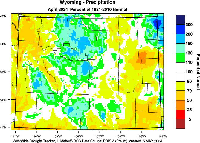 | 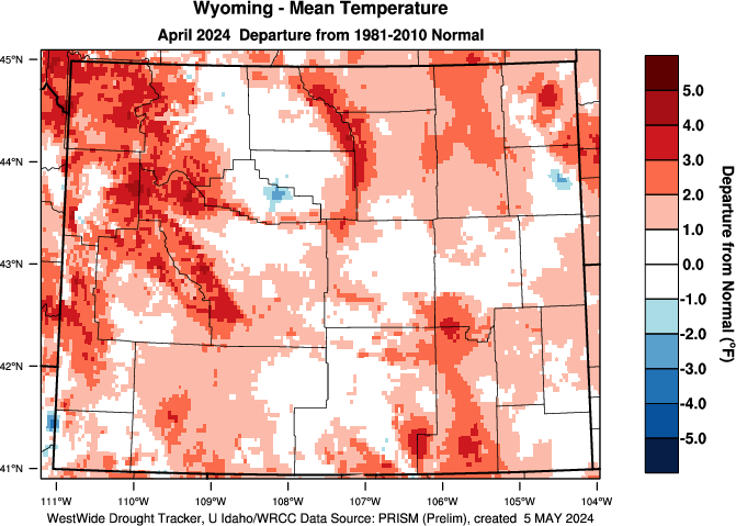 | |||||||||||
| Statewide Average (inches) | Statewide Average (°F) | |||||||||||
| 20th Century Average | 20th Century Average | |||||||||||
| Rank - Driest to Wettest (119 Years) | Rank - Warmest to Coldest (119 Years) | |||||||||||
| Driest Year on Record: 1944 | Warmest Year on Record: 2003 | |||||||||||
| Last 3 Months | ||||||||||||
| Precipitation - Percent of Normal | Temperature - Departure from Normal | |||||||||||
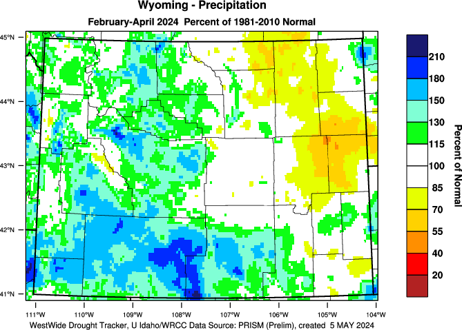 | 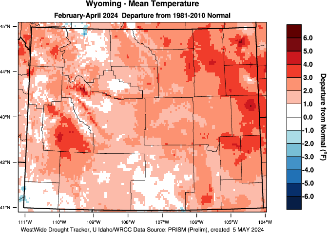 | |||||||||||
| Statewide Average (inches) | Statewide Average (°F) | |||||||||||
| 20th Century Average | 20th Century Average | |||||||||||
| Rank - Driest to Wettest (119 Years) | Rank - Warmest to Coldest (119 Years) | |||||||||||
| Driest Year on Record: 2012 | Warmest Year on Record: 2012 | |||||||||||
| Water Year | ||||||||||||
| Precipitation - Percent of Normal | Temperature - Departure from Normal | |||||||||||
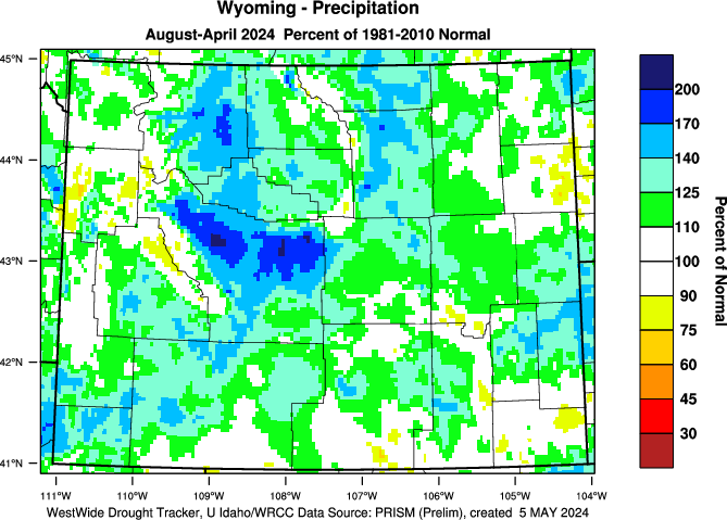 | 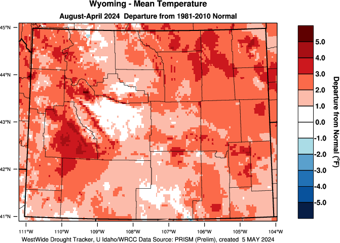 | |||||||||||
| Statewide Average (inches) | Statewide Average (°F) | |||||||||||
| 20th Century Average | 20th Century Average | |||||||||||
| Rank - Driest to Wettest (119 Years) | Rank - Warmest to Coldest (119 Years) | |||||||||||
| Driest Period on Record: Oct 1918 - Aug 1919 | Warmest Period on Record: Oct 1933 - Aug 1934 | |||||||||||
| Last 12 Months | ||||||||||||
| Precipitation - Percent of Normal | Temperature - Departure from Normal | |||||||||||
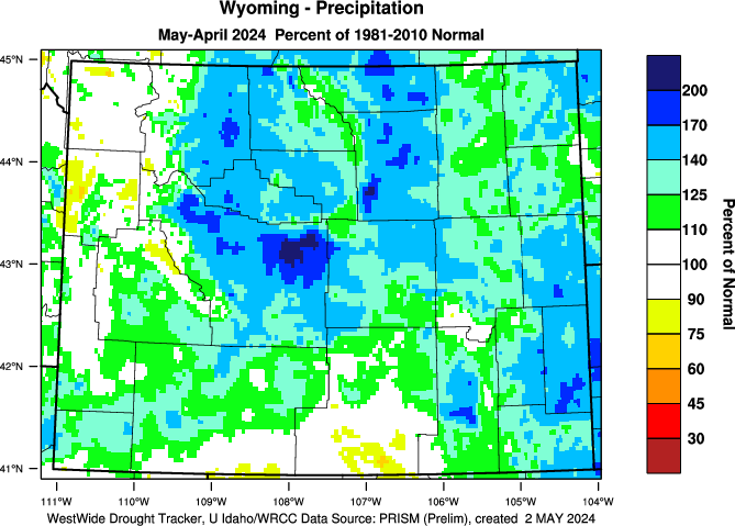 | 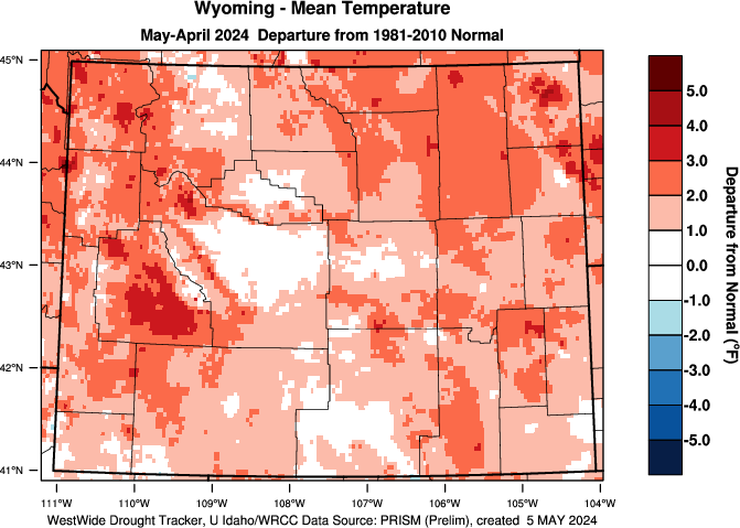 | |||||||||||
| Statewide Average (inches) | Statewide Average (°F) | |||||||||||
| 20th Century Average | 20th Century Average | |||||||||||
| Rank - Driest to Wettest (119 Years) | Rank - Warmest to Coldest (119 Years) | |||||||||||
| Driest Period on Record: Sep 1987 - Aug 1988 | Warmest Period on Record: Aug 1933 - Aug 1934 | |||||||||||
Subscribe to:
Posts (Atom)


