Thursday, May 24, 2012

Stormy Start to the Memorial Day Weekend


The advertised pattern change has occurred and the warm, sunny weather of mid May across Star Valley is over for now.  The strong polar jet that moved in off  the Pacific is now located just to our south. 

300 mb analysis Thursday morning 5/24/12

This Thursday morning the strong and cold westerly flow is providing periods of wet snow, heavy at times,across the Valley.  A photo taken from Star Valley Ranch late Thursday morning is visible evidence.


The following series of 500 mb forecast charts shows an intense upper low that develops within the strong jet stream and its path over the  Memorial Day Weekend.

500 mb analysis Thursday morning 5/24/12  

500 mb forecast Friday morning 5/25/12

500 mb forecast Saturday morning 5/26/12
500 mb forecast Sunday morning 5/27/12
With the upper low dropping southeastward into California Friday, the upper flow turns  more southerly across Western Wyoming and Southeast Idaho, which will bring a warmer air mass northward. The snow level will rise above Star Valley by tonight, leading to a warmer day on Friday.  While showers will still be possible Friday, any snow should be confined to the higher elevations.

The 700mb chart from this morning compared to the forecast for Friday evening depicts  warming of the air mass in western Wyoming.

700 mb analysis Thursday morning 5/24/12

700mb forecast Friday evening 5/25/12
Another period of possibly significant precipitation will occur as the upper low moves northeastward across the area later Saturday into Sunday morning.  For the duration of the next 3 days, the model forecasts an inch or more of precipitation from the Star Valley area northward.

Model Forecast precipitation Thursday morning to Sunday morning 5/24-27/2012

The greatest impact from this storm appears to be north of Star Valley where potentially heavy snow fall from one to two feet is possible in the higher mountains such as the Bear Tooth in Southern Montana.  Here is a  statement issued by the Great Falls WFO for Montana to alert weekend travelers.

http://www.wrh.noaa.gov/FXC/wxstory.php?wfo=tfx


Saturday, May 19, 2012

Active Weather Pattern Returning to Wyoming

After a period of unseasonably pleasant weather across much of the Cowboy state a more typical springtime pattern is returning to Wyoming.  The first system that brought upwards of a half inch of much needed rain to Star Valley Friday, also produced the first significant severe thunderstorm event of the year  in the Riverton/Lander area during the afternoon.  Gusts of winds above 70mph, lots of small hail and very heavy rain accompanied a line of thunderstorms that moved off the Wind Rivers by mid afternoon.

Riverton WFO provided documentation of the event which can be accessed through this link

http://www.crh.noaa.gov/news/display_cmsstory.php?wfo=riw&storyid=83249&source=0

Following is a series of  500mb forecast charts for the next several days which shows the transitory ridge of high pressure that will bring a couple of days of very nice weather, followed by a series of systems accompanying a strong Pacific jet storm that moves into the Western States.

500 mb Analysis Saturday Morning  5/19/12


500 mb Forecast  Monday Morning 5/21/12

500 mb Forecast Tuesday evening 5/22/12


500 mb Forecast Thursday evening 5/24/12

While it is too soon to confidently provide detailed forecasts for when and how much precipitation will develop with this pattern change, it certainly supports a cool and wet period across Star Valley and much of Wyoming beginning by later Tuesday into the coming weekend.  Snow will return to the mountains by mid week.  Even Star Valley could see some wet snow, possibly as soon as later Wednesday.

Tuesday, May 15, 2012

Wyoming Precipitation

Since the most recent Snowfall season has about ended(as anyone who lives in Wyoming knows the only months you can count on it not snowing are July and August) it is of interest to look at some of the excellent precipitation graphics that are available through the National Weather Service.

For an overview the first image is one of the normal annual precipitation that occurs over the 48 states.

"Normal" precipitation is derived from PRISM climate data, created at Oregon State University. The PRISM gridded climate maps are considered the most detailed, highest-quality spatial climate data sets currently available. The 30 year PRISM normal from 1971-2000 is used for precipitation analysis since 2004. Prior to 2004 the 30 year PRISM normal from 1961-1990 is used.


Once east of the Rockies the amount of precipitation that falls generally increases the further east and south toward the Gulf of Mexico and Atlantic Ocean. Over the Western states, it is quickly obvious the major role that the mountains play.  The greatest amounts fall generally over and west of the Cascades and Sierras Nevada Mountains.  In some place over 100 inches of precipitation is the normal amount!

Zooming in on the State of Wyoming and examining the precipitation distribution  it is easily seen the tremendous role the terrain plays.


The major mountain ranges of western Wyoming coincides with the greatest precipitation amounts. The Tetons normally experience upwards to 70 inches with the Salt Range40- 50 inches.  Amounts in Star Valley are around 20 inches.

The east side of the Western Wyoming mountain ranges generally receive less than 10 inches in a typical year.

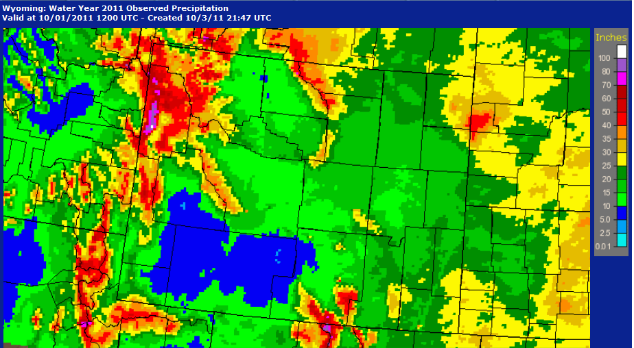
The Water Year 2011 which extended from Oct 2010 to Oct 2011 was very wet across much of Wyoming as show in this image


Amounts ranged upwards to near 100 inches in the Tetons with much of Star Valley in excess of 25 inches.  All of western Wyoming was well above normal, except for the normally dry east side of the mountains where generally as little as 5 inches fell.

While the current water year has another 4 months to go, it can be seen that it has been  a much drier period.

It has been particularly dry on the east side of the mountains with only a couple inches having fallen since October 2011.  Typically the summer months do not provide much useful precipitation for purposes of water supply, so it is fortunate that most of the states reservoirs are still flush with the previous winters bountiful runoff.

Monday, May 7, 2012

Best Time to Plant Vegetable Seeds in Star Valley


The second week in May will see Star Valley warming to above normal daytime temperatures with 60s and possibly low 70s under mostly sunny skies. There were even warmer periods in April when near record temperatures occurred.

Thayne Elementary Maximum Temperatures April 7-May 7 2012

Given the unusually warm start to Spring the question is when  would be the favorable time to plant seeds for the summer gardens.  It is instructive to first look at the table  below that shows the soil temperatures(about 4 inches deep) when germination is most likely.


With the Thayne Elementary weather station having three soil temperature sensors( near the surface, 2 feet and 4 feet), it is interesting to compare how the soil is warming up at different levels coupled with the air temperature.

This first graph shows the 2 foot deep sensor over the last 6 plus months.

Two foot soil temperature Oct 1 2011 to May 7 2012

The temperature held around freezing from the first of January until the end of March when the snow cover melted.

For the past month even though April experienced unusually warm conditions, the soil temperature warmed only gradually.

Maximum air temperature and 2 foot soil temperature April 7-May 7 2012


Referring to the above table for seed germination, even though it was a warm April, only a very few seeds would germinate at 40F. The study was done for a 4 inch level, however both the 2 and 4 foot level temperatures were similar

Yellow  4 foot and red 2 foot soil temperatures April 6-May 7 2012


The first soil sensor just below the surface has large diurnal ranges

Sub-surface soil sensor April 6-May 7 2012


Thus at a 4 inch depth per the table the Thayne temperature at 4 inches is likely slightly warmer than the 2 and 4 foot levels.

There are several vegetable seeds that are not adaptable to the not only short growing season in Star Valley but also as can be seen from the observed 2 foot sensor temperatures from late last summer, which did not exceed 60F,  remains too cool.

Two foot soil  temperature August 15-September 15 2011

The soil temperatures can be accessed on line at any time at the Thayne Elementary weather station using this link

http://www.weatherlink.com/user/thayne/index.php?view=summary&headers=1


Saturday, May 5, 2012

Brief Return to Winter Scene

Star Valley woke up Saturday morning to a somewhat surprise. A cold front crossed through the valley around 3am followed by a couple hours of wet snow.  By mid morning skies were clearing after up to 2 inches of snow fell at Star Valley Ranch and a lessor amount at lower elevations.  By mid afternoon the morning winter scene will already be a memory as the strong May sun should make short work of the snow.  Here are some pictures taken this morning at Star Valley Ranch before the melting began.


High Pressure takes control and after a general freeze across the valley Sunday morning, several days of beautiful Spring weather are ahead as afternoon temperatures return to the 60s.