Saturday, March 28, 2015

Windy Saturday Across the Cowboy State

A strong cold front raced east across west and central Wyoming Saturday afternoon.  The front produced a few thunderstorms over the northwest mountains,
but the main impacts were record high temperatures ahead of the front on Friday and Saturday and strong winds with the frontal passage.  A peak wind gust
 of
71 mph was recorded at the Lander airport at 258 PM on Saturday.  The highest gust reported so far was 84 mph at a station 5 miles west northwest of Clark, recorded
at 1136 AM Saturday. Record or near record high temperatures are listed below along with peak wind gusts.  These lists will be updated as we receive more information. 
 
...Peak WInd Gusts on Saturday, March 28th, through 730 PM...
LOCATION                     SPEED     TIME/DATE                            

...BIG HORN COUNTY...
GREYBULL AIRPORT (3935 FT)   56 MPH    0300 PM 03/28                        
COWLEY AIRPORT (4090 FT)     52 MPH    0415 PM 03/28                        
30 E GREYBULL (8898 FT)      50 MPH    0458 PM 03/28                        
5 ENE HYATTVILLE (5670 FT)   49 MPH    0452 PM 03/28                        
LOVELL (3830 FT)             47 MPH    0234 PM 03/28                        

...FREMONT COUNTY...
LANDER AIRPORT (5586 FT)     71 MPH    0258 PM 03/28                        
LAVA MOUNTAIN (10371 FT)     64 MPH    0115 PM 03/28                        
7 SW MUDDY GAP (7380 FT)     62 MPH    0550 PM 03/28                        
CROWHEART (6099 FT)          58 MPH    0134 PM 03/28                        
10 W FORT WASHAKIE (9235 FT) 57 MPH    1201 PM 03/28                        
RIVERTON AIRPORT (5525 FT)   54 MPH    0336 PM 03/28                        
8 W SOUTH PASS CITY (8120 FT 53 MPH    0350 PM 03/28                        
JEFFREY CITY (6374 FT)       50 MPH    0411 PM 03/28                        
4 SW LANDER (5807 FT)        49 MPH    0119 PM 03/28                        
N WIND RIVER MTS (8833 FT)   46 MPH    0310 PM 03/28                        
10 WNW BAIROIL (7976 FT)     46 MPH    0434 PM 03/28                        
DUBOIS (6980 FT)             45 MPH    0259 PM 03/28                        

...HOT SPRINGS COUNTY...
10 S MEETEETSE (7127 FT)     70 MPH    0242 PM 03/28                        
1 WSW THERMOPOLIS (4426 FT)  54 MPH    0315 PM 03/28                        
KIRBY (4350 FT)              46 MPH    0118 PM 03/28                        

...JOHNSON COUNTY...
2 NW MAYOWORTH (5404 FT)     55 MPH    0254 PM 03/28                        
KAYCEE (4681 FT)             48 MPH    0447 PM 03/28                        
BUFFALO AIRPORT (4970 FT)    47 MPH    0619 PM 03/28                        

...LINCOLN COUNTY...
THAYNE E.S.                  40 MPH    0218 PM 03/28
STAR VALLEY RANCH            40 MPH    0123 PM 03/28
ETNA E.S.                    39 MPH    0238 PM 03/28
2 S BEDFORD                  37 MPH    0233 PM 03/28
ALPINE                       38 MPH    0205 PM 03/28     
KEMMERER AIRPORT (7285 FT)   54 MPH    0215 PM 03/28                        

...NATRONA COUNTY...
16 S HILAND (6380 FT)        65 MPH    0510 PM 03/28                        
CASPER AIRPORT (5320 FT)     56 MPH    0349 PM 03/28                        
MIDWEST (4865 FT)            50 MPH    0502 PM 03/28                        
8 S CASPER (7740 FT)         47 MPH    0552 PM 03/28                        

...PARK COUNTY...
5 WNW CLARK (4659 FT)        84 MPH    1136 AM 03/28                        
CHIEF JOSEPH HWY MILE 9      69 MPH    0212 PM 03/28                        
1 WNW POWELL (4386 FT)       68 MPH    0230 PM 03/28                        
1 W CLARK (4270 FT)          63 MPH    1240 PM 03/28                        
20 SW CODY (5843 FT)         60 MPH    0127 PM 03/28                        
3 W POWELL (4505 FT)         56 MPH    0238 PM 03/28                        
10 WNW CODY (8401 FT)        56 MPH    0240 PM 03/28                        
POWELL AIRPORT (5050 FT)     55 MPH    0255 PM 03/28                        
CODY AIRPORT (5100 FT)       48 MPH    0115 PM 03/28                        
PORTABLE RAWS (7137 FT)      48 MPH    0102 PM 03/28                        
2 N FRANNIE (4275 FT)        46 MPH    0400 PM 03/28                        
3 E PAHASKA (7500 FT)        44 MPH    0657 PM 03/28                        

...SUBLETTE COUNTY...
BIG PINEY AIRPORT (6974 FT)  55 MPH    0224 PM 03/28                        
MARBLETON (6896 FT)          44 MPH    0302 PM 03/28                        
PINEDALE AIRPORT (7085 FT)   44 MPH    0315 PM 03/28                        

...SWEETWATER COUNTY...
22 NNE GRANGER (6322 FT)     59 MPH    0248 PM 03/28                        
ROCK SPRINGS AIRPORT (6760 F 55 MPH    0426 PM 03/28                        
15 SE ROCK SPRINGS (7550 FT) 46 MPH    0544 PM 03/28                        

...WASHAKIE COUNTY...
WORLAND AIRPORT (4245 FT)    56 MPH    0237 PM 03/28                        

OBSERVATIONS ARE COLLECTED FROM A VARIETY OF SOURCES WITH VARYING
EQUIPMENT AND EXPOSURE. NOT ALL DATA LISTED ARE CONSIDERED OFFICIAL.

$$

NWS RIVERTON WY
IRIS SYSTEM


Friday, March 27, 2015

Weekly Wyoming Weather Video


The following link is to a Video provided by the Riverton Forecast Office covering expected weather into next week.

Video of Western Wyoming Weather

Wednesday, March 25, 2015

Snow Totals for March 24-25 2015


PUBLIC INFORMATION STATEMENT
NATIONAL WEATHER SERVICE RIVERTON WY
1250 PM MDT WED MAR 25 2015

...PRELIMINARY SNOWFALL TOTALS FROM OUR LATEST STORM SYSTEM TUESDAY
MORNING THROUGH THIS MORNING...

LOCATION                             SNOWFALL
LINCOLN COUNTY...
 SALT RIVER SUMMIT SNOTEL...          8 INCHES.
 WILLOW CREEK SNOTEL...               8 INCHES.
 COMMISSARY RIDGE...                  7 INCHES.
 COTTONWOOD CREEK SNOTEL...           7 INCHES.
 INDIAN CREEK SNOTEL...               6 INCHES.
 BLIND BULL SUMMIT...                 6 INCHES.
 STAR VALLEY RANCH...                 5 INCHES.
 SPRING CREEK DIVIDE SNOTEL...        5 INCHES.
 BOX Y RANCH...                       5 INCHES.
 ALPINE...                          4.5 INCHES.
 BLIND BULL SUMMIT SNOTEL...          4 INCHES.
 ALPINE...                            4 INCHES.
 5 SSE SMOOT...                       4 INCHES.
 KELLEY RANGER STATION SNOTEL...      4 INCHES.
 HAMS FORK SNOTEL...                  2 INCHES.
 AFTON...                           0.4 INCHES.
BIG HORN COUNTY... BONE SPRINGS DIVIDE SNOTEL... 2 INCHES. BALD MOUNTAIN SNOTEL... 2 INCHES. FREMONT COUNTY... BROOKS LAKE... 12 INCHES. BURROUGHS CREEK SNOTEL... 8 INCHES. HUDSON... 2.5 INCHES. COLD SPRINGS SNOTEL... 2 INCHES. SOUTH PASS SNOTEL... 2 INCHES. LITTLE WARM SNOTEL... 2 INCHES. TOWNSEND CREEK SNOTEL... 2 INCHES. RIVERTON AIRPORT... 1.5 INCHES. RIVERTON... 1.2 INCHES. 9 SSE LANDER... 1.1 INCHES. JEFFREY CITY... 1 INCH. ST. LAWRENCE ALT SNOTEL... 1 INCH. CASTLE CREEK SNOTEL... 1 INCH. DEER PARK SNOTEL... 1 INCH. HOBBS PARK SNOTEL... 1 INCH. 9 SSE LANDER... 1 INCH. LANDER... 0.5 INCHES. BOYSEN DAM... 0.5 INCHES. 6 SW LANDER... 0.4 INCHES. LANDER AIRPORT... 0.3 INCHES. 7 WNW LANDER... 0.1 INCHES. HOT SPRINGS COUNTY... JOHNSON COUNTY... LITTLE GOOSE SNOTEL... 3 INCHES. CLOUD PEAK RESERVOIR SNOTEL... 3 INCHES. 17 NNW KAYCEE... 2.3 INCHES. NATRONA COUNTY... RENO HILL SNOTEL... 4 INCHES. GRAVE SPRING SNOTEL... 3 INCHES. POWDER RIVER... 1 INCH. 1 NW ALCOVA... 1 INCH. CASPER... 0.4 INCHES. CASPER... 0.3 INCHES. PARK COUNTY... EVENING STAR SNOTEL... 4 INCHES. BLACKWATER SNOTEL... 3 INCHES. KIRWIN SNOTEL... 3 INCHES. MARQUETTE SNOTEL... 3 INCHES. PAHASKA... 3 INCHES. BEARTOOTH LAKE SNOTEL... 2 INCHES. 3 NE SUNSHINE... 0.3 INCHES. 26 SW CODY... 0.2 INCHES. 3 W WAPITI... 0.1 INCHES. SUBLETTE COUNTY... TRIPLE PEAK SNOTEL... 7 INCHES. LOOMIS PARK SNOTEL... 7 INCHES. NEW FORK LAKE SNOTEL... 6 INCHES. KENDALL RANGER STATION SNOTEL... 5 INCHES. SNIDER BASIN SNOTEL... 4 INCHES. LARSEN CREEK SNOTEL... 3 INCHES. ELKHART PARK G.S. SNOTEL... 3 INCHES. BIG SANDY OPENING SNOTEL... 3 INCHES. POCKET CREEK SNOTEL... 2 INCHES. EAST RIM DIVIDE SNOTEL... 2 INCHES. 14 NW PINEDALE... 1.3 INCHES. GUNSITE PASS SNOTEL... 1 INCH. PINEDALE... 0.5 INCHES. SWEETWATER COUNTY... TETON COUNTY... TOGWOTEE MOUNTAIN LODGE... 12 INCHES. JACKSON HOLE - RAYMER... 12 INCHES. JACKSON HOLE - RENDEZVOUS BOWL... 11 INCHES. TOGWOTEE PASS SNOTEL... 10 INCHES. JACKSON HOLE - MID MOUNTAIN... 10 INCHES. 3 SSW WILSON... 9.5 INCHES. GRASSY LAKE SNOTEL... 9 INCHES. PHILLIPS BENCH SNOTEL... 9 INCHES. GRANITE CREEK SNOTEL... 9 INCHES. SNAKE RIVER STN SNOTEL... 8 INCHES. GRAND TARGHEE - CHIEF JOSEPH... 7 INCHES. GRAND TARGHEE SNOTEL... 7 INCHES. BASE CAMP SNOTEL... 7 INCHES. MOOSE... 6.5 INCHES. SNOW KING... 5 INCHES. MOOSE... 4 INCHES. JACKSON HOLE - BASE... 4 INCHES. GROS VENTRE SUMMIT SNOTEL... 3 INCHES. JACKSON... 2 INCHES. WASHAKIE COUNTY... POWDER RIVER PASS SNOTEL... 4 INCHES. YELLOWSTONE NATIONAL PARK... LEWIS LAKE DIVIDE SNOTEL... 13 INCHES. TWO OCEAN PLATEAU SNOTEL... 9 INCHES. SYLVAN ROAD SNOTEL... 7 INCHES. SYLVAN LAKE SNOTEL... 5 INCHES. PARKER PEAK SNOTEL... 4 INCHES. CANYON SNOTEL... 3 INCHES. THUMB DIVIDE SNOTEL... 3 INCHES. TOWER FALLS RANGER STATION... 1 INCH. CANYON... 1 INCH. LAMAR RANGER STATION... 0.5 INCHES.

Tuesday, March 24, 2015

California Drought Affecting Lake Tahoe

Low lake level changing life at Lake Tahoe


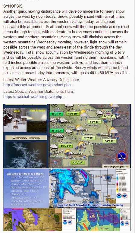
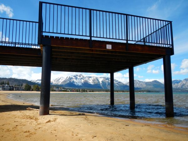
No water is flowing from Lake Tahoe to the Truckee River. Photos/Kathryn Reed
Publisher’s note: Lake Tahoe News spent March 22 driving around the lake looking at and documenting more than 20 locations to show what the drought looks like throughout the basin all on the same day.
By Kathryn Reed
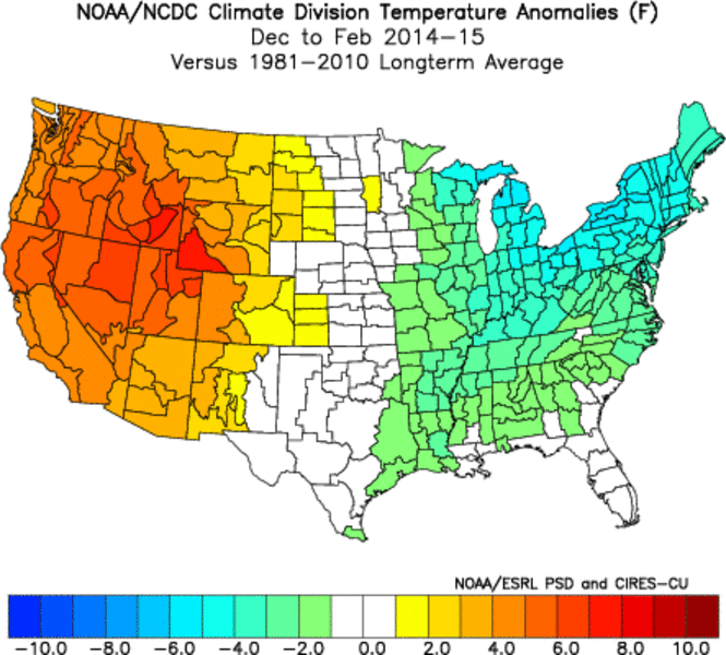
It’s not unusual for Lake Tahoe to drop below its rim. What is unusual is when the spring runoff doesn’t bring it back up and above that 6,223-foot mark.
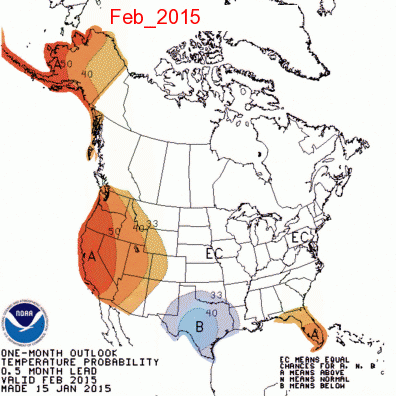
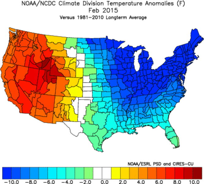
“This year the way things look it would take some pretty big precipitation to get back above its natural rim this year,” Scott McGuire, meteorologist with the National Weather Service in Reno, told Lake Tahoe News. “The projection is for Lake Tahoe to be significantly below its rim by fall 2015.”
ANALYSIS
When it fell below the rim in October 2014, this was the first time in five years. Some of the other times it was below the rim were 1977-78, 1961-62 and 1930-36.
On March 22, Lake Tahoe was at 6222.83 feet.
The record low of 6220.25 feet was set in 1992. (Records have been kept since 1900.)
In 2014, the snowmelt added 3 inches to Lake Tahoe. With substantially less snow falling this winter, it is near impossible the lake will rise by that much this spring.
Seasonal businesses were hurting last summer as documented by Lake Tahoe News.  For many of those same businesses it will only be worse this year.
Business owners may need to rethink how and when they do business because the model used even three to five years ago isn’t going to work today.
Instead of trying to get a jumpstart on Mother Nature with opening ski resorts pre-Thanksgiving, it might be time to have an intense, stellar shorter ski season. Then crank up the public relations to woo out-of-towners here for spring – a season often ignored.
If the weather patterns of the last few years are the new normal, it will mean learning to adapt to less snow and more summer-like days. In some ways this could be good for the Lake Tahoe Basin because summer has always been the busiest season. It may mean that season is now longer.
And if it’s hotter in the Central Valley and Bay Area sooner and longer, people may drive to Tahoe to cool off and recreate. This might solve the shoulder season blues.
Driving around the lake on Sunday was at times reminiscent of a summer weekend. Parking lots were full of people enjoying the outdoors. Restaurants were busy – at least the ones that were open.
Jumping in off piers and docks at Lake Tahoe is not advised.
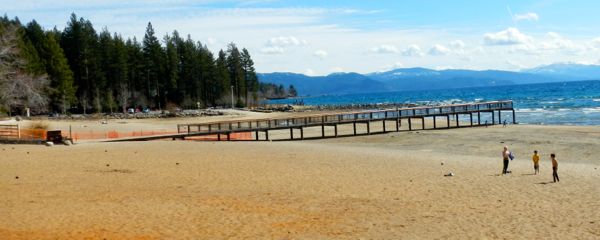
Jumping off piers and docks at Lake Tahoe is not advised.
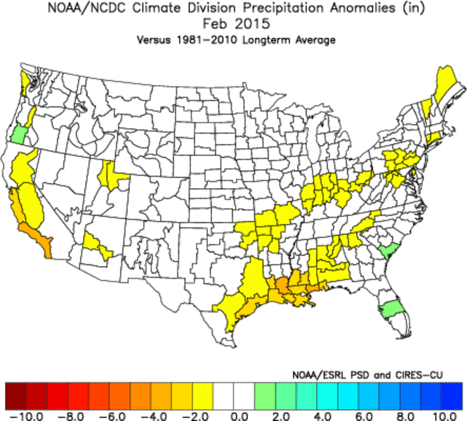
Signs of drought
For those in California, there will be much more beach access this year. (Nevada has different rules when it comes to public access on private beaches.) Sand and rocks are exposed in places that have not seen the light of day in years.
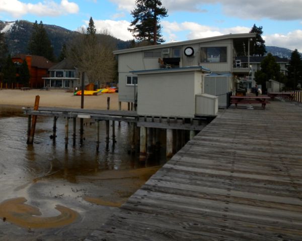
So many piers have little or no water under them. Signs saying “no diving, no jumping” are posted in some locales. It’s advice that will need to be adhered to at all piers and docks this year to avoid injury or worse.
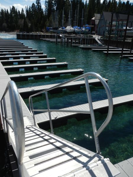
Floating docks will have an easier time accommodating people. Many marinas have a combo of fixed and floating structures. This means the ramp between the two keeps getting steeper. Some are clearly not in compliance with the Americans with Disabilities Act. It would be tricky to walk down them carrying a cooler or small child.
Water marks on bulkheads and boulders are visible symbols of just how far the lake level has fallen.
Tahoe piers-drought: Tahoe Keys
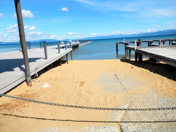
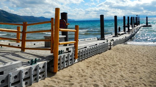
Tahoe Keys Property Owners Association Pier
Four of the six pilings making the extended seating area at the pier are in water – 6 inches at the deepest.
A small sandbar has been created near the shore, which has allowed pooling to occur between the beach and lake. The area nearest the water is muddy and uninviting.
Across the channel is Cove East, which extends even farther into the lake. But it, too, has a large swath that is more swampish than beach-like.
Tahoe piers-drought: Camp RichCamp Richardson
Much of the boat ramp is sand. The water level by the gas pumps looks as though not many boats would have clearance to get to them. They are on the fixed dock, so they seem even higher as the lake gets lower.
Looking down Jameson Beach, most of the private docks are covering only sand.
Tahoe piers-drought: Emerald BayEmerald Bay
Navigating the entrance to the bay was tricky last boating season. It’s only going to be worse this year, with some boats not able to get in.
It’s as though most of the bay is rimmed by sand. At the end by Vikingsholm and below the swath of mountain that decades ago sustained a landslide is debris from that slide that had been under water.
Tahoe piers-drought: Meeks BayMeeks Bay Resort
The sand, even near the water, is silky white. The water is incredibly clear, at times reflecting various hues of blue. It’s Caribbean-like.
The end of the walkway is now far from the water.
While the channel inside the bulkhead leading to the docks and boat launch is deep, the lake level outside this area is not going to permit all boats to come and go.
Tahoe piers-drought: Sugar Pine PointSugar Pine Point State Park
With all the rocks and pine cones on the beach, it won’t beckon sunbathers like the beach down the road does. Many more rocks are visible than last fall.
The last rung on the swim ladder at the end of the pier is no longer in the water.
Tahoe piers-drought: West Shore
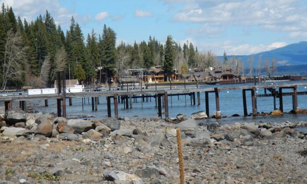
Between Tahoma and Homewood
White moorings bob in the lake, only time will tell if they will be filled with boats. Not all marinas will be accessible for launching, and then some of the moorings will be in too shallow of water for deep-hulled vessels.
So many private docks along this stretch of the West Shore as well as ones closer to Tahoe City are covering rocks instead of water.
pier-obexersObexer’s
Water is no longer touching the concrete on the boat launch. Trailers will be backing onto rocks.
The ramps here have some of the more extreme angles going from the fixed pier to the floating docks.
Tahoe piers-drought: Tahoe City Dam, Truckee RiverTahoe City Dam
It’s possible to walk near the base of the dam because of the lack of water on the Lake Tahoe side of the dam. Buoys that say “Danger Dam” seem silly and sad without water.
On the other side of the dam there is water, but looking farther down the Truckee River it is more rocks than water.
This means the rafting season on the Truckee River is likely a no-go.
Tahoe piers-drought: Tahoe CityCommons Beach/Tahoe City Marina
Walking along the Lakeside Trail the lake is a little farther away. People don’t seem to mind as they wander along the rocks.
Tahoe piers-drought: Tahoe Vista Recreation AreaTahoe Vista Recreation Area
No boats will be launched here anytime soon.
Tahoe piers-drought: Kings BeachKings Beach
The pier covers more sand than water.
California Tahoe Conservancy and California Department of Parks and Recreation are hosting a workshop April 1 from 6:30-8pm seeking input on the feasibility and design for a reconstructed public pier.
Tahoe piers-drought: Lone EagleLone Eagle Pier
The gate on the dock preventing people from walking to the end is over sand so it’s useless right now.
Tahoe piers-drought: Sand HarborSand Harbor
While this area is always rocky, now large boulders are exposed. Plenty of sand exists. The canvas Mother Nature is working with keeps getting more beautiful.
Tahoe piers-drought: GlenbrookGlenbrook
The creek running into the lake near the pier is rippling across a rocky beach. The pier looks more like something out of bygone Tahoe than a functioning structure today.
Tahoe piers-drought: Cave RockCave Rock
One of the few boat launches in the basin that is useable. Rocks, though, continue to be exposed near the beach area.
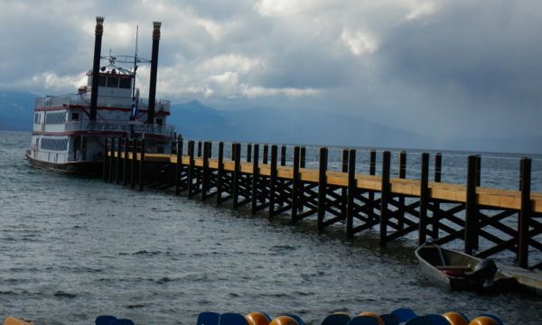
Tahoe piers-drought: Zephyr CoveZephyr Cove
The new dock is installed. The M.S. Dixie II wil run again after it is rehabbed.
Tahoe piers-drought: Ski RunSki Run Marina
The Tahoe Queen will be able to run again when the channel is dredged.
Tahoe piers-drought: Timber CoveTimber Cove Marina
Access via Bal Bijou Road still isn’t available because of Tahoe Beach Retreat’s lingering construction project. (The hotelier is also still arguing with South Lake Tahoe about signage on the beach.)
It would be hard to get a kayak under most areas of the pier because of the shallow water and sand bars. The gas pump on the dock is completely inaccessible.

Tahoe piers-drought: Lakeview CommonsEl Dorado Beach Boat Launch/Lakeview Commons/Regan Beach
This launch has been off-limits for years. Now there is no chance anyone will drive onto the dirt to get to the water because of the boulders at the end of the launch.
With the amount of beach area, a much larger stage could be erected for Live at Lakeview Commons.
Pilings from piers of eras gone by can be seen from here down Lakeview Avenue past Regan Beach. At Regan Beach the dog beach used to be mostly water – not so anymore.

Snow Returns to Western Wyoming

The  Riverton Forecast Office issued a statement on the current snowy weather that is spreading across Western Wyoming


Wednesday, March 18, 2015

California has about one year of water left. This is serious!!

This is an article by Jay Famiglietti who is the senior water scientist at the NASA Jet Propulsion Laboratory/Caltech and a professor of Earth system science at UC Irvine.

The rain season is coming to an end within the next month in California and it has been another very poor winter for creating a snow pack in the mountains.

Given the historic low temperatures and snowfalls that pummeled the eastern U.S. this winter, it might be easy to overlook how devastating California’s winter was as well.
As our “wet” season draws to a close, it is clear that the paltry rain and snowfall have done almost nothing to alleviate epic drought conditions. January was the driest in California since record-keeping began in 1895. Groundwater and snowpack levels are at all-time lows. We’re not just up a creek without a paddle in California, we’re losing the creek too.
DROUGHT-videoSixteenByNine1050-v2
Statewide Drought Takes Toll On California's Lake Oroville Water Level
california-drought-4
Data from NASA satellites show that the total amount of water stored in the Sacramento and San Joaquin river basins – that is, all of the snow, river and reservoir water, water in soils and groundwater combined – was 34 million acre-feet below normal in 2014. That loss is nearly 1.5 times the capacity of Lake Mead, America’s largest reservoir.
Statewide, we’ve been dropping more than 12 million acre-feet of total water yearly since 2011. Roughly two-thirds of these losses are attributable to groundwater pumping for agricultural irrigation in the Central Valley. Farmers have little choice but to pump more groundwater during droughts, especially when their surface water allocations have been slashed 80% to 100%. But these pumping rates are excessive and unsustainable. Wells are running dry. In some areas of the Central Valley, the land is sinking by one foot or more per year.
One drop on wheat corn and dry land
As difficult as it may be to face, the simple fact is that California is running out of water – and the problem started before our current drought. NASA data reveal that total water storage in California has been in steady decline since at least 2002, when satellite-based monitoring began, although groundwater depletion has been going on since the early 20th century.
Right now the state has only about one year of water supply left in its reservoirs, and our strategic backup supply, groundwater, is rapidly disappearing. California has no contingency plan for a persistent drought like this one (let alone a 20-plus-year mega-drought), except, apparently, staying in emergency mode and praying for rain.
In short, we have no paddle to navigate this crisis.
comparison california drought
Several steps need be taken right now. First, immediate mandatory water rationing should be authorized across all of the state’s water sectors, from domestic and municipal through agricultural and industrial. The Metropolitan Water District of Southern California is already considering water rationing by the summer unless conditions improve. There is no need for the rest of the state to hesitate. The public is ready. A recent Field Poll showed that 94% of Californians surveyed believe that the drought is serious, and that one-third support mandatory rationing.
Second, the implementation of the Sustainable Groundwater Management Act of 2014 should be accelerated. The law requires the formation of numerous, regional groundwater sustainability agencies by 2017. Then each agency must adopt a plan by 2022 and “achieve sustainability” 20 years after that. At that pace, it will be nearly 30 years before we even know what is working. By then, there may be no groundwater left to sustain.
Third, the state needs a task force of thought leaders that starts, right now, brainstorming to lay the groundwork for long-term water management strategies. Although several state task forces have been formed in response to the drought, none is focused on solving the long-term needs of a drought-prone, perennially water-stressed California.
california snowpack
Our state’s water management is complex, but the technology and expertise exist to handle this harrowing future. It will require major changes in policy and infrastructure that could take decades to identify and act upon. Today, not tomorrow, is the time to begin.
Finally, the public must take ownership of this issue. This crisis belongs to all of us – not just to a handful of decision-makers. Water is our most important, commonly owned resource, but the public remains detached from discussions and decisions.
This process works just fine when water is in abundance. In times of crisis, however, we must demand that planning for California’s water security be an honest, transparent and forward-looking process. Most important, we must make sure that there is in fact a plan.
Call me old-fashioned, but I’d like to live in a state that has a paddle so that it might also still have a creek.
MO7iuWDm1pB5Xm
Jay Famiglietti is the senior water scientist at the NASA Jet Propulsion Laboratory/Caltech and a professor of Earth system science at UC Irvine.

Much of the Globe had a warm February 2015

February 2015 will be recalled as one of the coldest and snowiest in some time over much of the eastern U.S.  While the western states enjoyed one of the mildest.  What really was most striking looking at the entire earth, was that with the exception of the cold eastern U.S., most areas were warmer to much warmer that normal, particularly in the Northern Hemisphere.


Snow Pack Almost gone in Star Valley Ranch

To visually display how rapid the snow is disappearing from the valley floor, the following photos from the Star Valley Ranch Snow stake cam are shown.

March 18 2013

March 18 2014

March 18 2015
 The actual now cover as of this morning March 18th  was about 5 inches and decreasing steadily.  Last year on March 18th there was still 30 inches on the ground.

Saturday, March 14, 2015

Snow Pack Report

As of March 14 2015, the snow pack in the Salt and Wyoming ranges is close to normal.  While it is not a super snow pack, much of the western states are in particularly poor shape going into the Spring runoff season.  Following are SNOTEL sites in the Salt and Wyoming Ranges indicating the near normal conditions.

Willow Creek SNOTEL
Cottonwood Creek SNOTEL
Spring Creek SNOTEL
Blind Bull SNOTEL
With regards to other western states, Wyoming is in great shape.  The snow pack in Oregon and Washington is near records lows and the ski season has been a major disappointment with mostly rain. Further south in California the drought continues unabated!

Snow Water Equivalent percent of normal as of March 14 2015.


Friday, March 13, 2015

Weekend Weather Video

Thanks to Riverton Forecast Office , here is the weekly weather briefing for western Wyoming.


Weekly Weather Video


Wednesday, March 11, 2015

Spring Runoff Outlook-March 9 2015

Wyoming Water Supply Outlook---issued March 9, 2015

…Wyoming February precipitation was nearly 110 percent of average...
...Current water year precipitation is averaging 90 to 95 percent of normal across Wyoming…
…Mountain snowpack across Wyoming continues to be 90 to 95 percent of average... 
Below normal snowmelt streamflow volumes are expected across major basins in Wyoming...
…Wyoming carryover reservoir storages are 115 to 125 percent of average for March…
February precipitation totals across Wyoming were nearly 110 percent of average. Precipitation numbers varied between 200 percent of normal over the Wind River Basin to near 65 percent of normal over the Belle Fourche Drainage (Northeast Wyoming).  Current water year (October 2014 - February 2015) precipitation across Wyoming is nearly 95 percent of average.


Mountain snowpack across Wyoming was 90 to 95 percent of normal by early March.  Snowpack "water" numbers and/or SWEs were the highest across basins in north central Wyoming---varying between 105 to 125 percent of median.  SWEs across southern Wyoming continued to be the lowest at 75 to 95percent of median.
Below normal (85 to 95 percent) snowmelt streamflow volumes are expected across almost all major basins across Wyoming.  Slightly above average streamflow volumes are expected across the Yellowstone/Clarks Fork as well as portions of the Powder and Tongue River Drainages.  Several southern Wyoming basins—including the Sweetwater, the Little Snake,  and the Bear---are forecasted to have well below normal streamflow volumes during the upcoming snowmelt season.
Carryover reservoirs storages across Wyoming continue to be above average (greater than 115 percent) for March. 
The latest Wyoming water supply outlook graphic:


Monday, March 9, 2015

Winter 2014/15 Forecast Final Grade


Jan Null, meteorologist in the San Francisco area, each year grades the winter outlook issued by the Climate Prediction Center.  It covers the 3 winter months of December, January and February.  Jan's final report for this winter is now available.  Here in Star Valley the forecast was for a slightly warmer than normal winter and equal chances of above/below normal precipitation.  Both forecasts were OK.  The forecast failed in the northeast which has suffered through one of their coldest winters in a while, which was not forecast!

Following is the summary of the winter by month with a discussion by Jan of the forecasts.


Winter 2014/15 Forecast Performance for Temperatures

Winter 2014/15 Performance for Precipitation


ABSTRACT
This review compares last year's NOAA Climate Prediction Center (CPC) 30-day and 90-day precipitation and temperature forecasts for the winter period of December-February (DJF) 2014-2015 with the actual observed conditons.

ANALYSIS
Winter Precipitation: 
 The CPC Winter precipitation forecast for DJF 2014-15 did poorly at capturing the negative precipitation anomalies for California and Oregon. It did capture the negative anomalies in Washington and the Midwest.  The above normal precipitation forecast along the southern tier of states only verified in a few places and was out of phase along much of the Gulf Coast and southern Florida.
Winter Temperature: For the second year in a row the winter temperature outlook for most of New England was a complete fail.  Above normal temperarures were forecast for most of West and verified well west of the Rockies but not in the Rockies and the western Plains.   The below normal forecast for most of the Southeast verified, but the remainder of the eastern half of the country was not well captured.
Monthly Precipitation and Temperature Analyses:  Forecast and observed conditons are graphically also depicted below.

Winter 2014-2015 Precipitation
NOAA CPC 90-Day Precipitation Outlook DJF 2014-2015Observed DJF 2014-2015 Precipitation Anomalies
Winter 2014-2015 Temperature
NOAA CPC 90-Day Temperature Outlook DJF 2014-2015Observed DJF 2014-2015 Temperature Anomalies

December 2014 Precipitation
NOAA CPC Precipitation Outlook December 2014Observed December 2014 Precipitation % Normal
December 2014 Temperature
NOAA CPC Temperature Outlook December 2014Observed December 2014 Temperature Anomalies

January 2015 Precipitation
NOAA CPC Precipitation Outlook January 2015Observed January 2015 Precipitation % Normal
January 2015 Temperature
NOAA CPC Temperature Outlook January 2015Observed January 2015 Temperature Anomalies

February 2015 Precipitation
NOAA CPC Precipitation Outlook February 2015Observed February 2015 Precipitation % Normal
February 2015 Temperature
NOAA CPC Temperature Outlook February 2015Observed February 2015 Temperature Anomalies

DATA SOURCESThe 30-day and 90-day outlooks were retreived from the NOAA Climate Prediction Center (CPC) archives and the corresponding observed temperature and precipitation data were downloaded from the High Plains Regional Climate Center's Climate Summary Maps.