The weekly weather briefing from the Riverton Forecast Office suggest continued high runoff and no big weather changes.
Western Wyoming Weekly Video Weather Briefing
Friday, May 30, 2014
Thursday, May 29, 2014
Rivers Are Rising
 |
| Bear Tooth Pass 5/24/2014 |
The Salt River in Star Valley continues to gradually rise and is around bankfull. the following graph of the river gauge on the Salt illustrates the higher runoff compared to last year.


Currently it has risen to 40% which can be seen below.

Tuesday, May 27, 2014
Watford North Dakota Tornado
 |
| Tornado near Watford ND May 26 2014 |
A tornado struck a mobile home park just south of Watford ND Monday evening, May 26, 2014. Several mobile homes were destroyed along with injuries. A video is available as the tornado tracked through the area and is quite impressive. Some of the language reflected the tense situation at the time.
Watford ND Video May 26 2014
Friday, May 23, 2014
Warm Memorial Day Weekend will Raise all Rivers
The Riverton Forecast Office is increasing awareness of the high runoff likely this weekend from the melting of the mountain snowpack. Following is their weekly Weather Video discussing what is ahead.
Riverton WFO Weekly Weather Video
Riverton WFO Weekly Weather Video
Thursday, May 22, 2014
Finally 80 Degrees Returns to Star Valley

After more than 8 months absence, 80 degrees have returned to Star Valley on this 22nd day of May. While the upper valley only managed the upper 70's, the Etna Elementary weather station topped out at 81 and Thayne Elementary 80.
It was back in the first week in September 2013, when the 80's left the valley for the Winter.
Following are the graphs at some of the valley weather stations since last September of the daily maximum and minimum temperatures.
 |
| Etna Elementary |
 |
| Star Valley Ranch |
 |
| Afton |
 |
| Thayne Elementary |
Monday, May 19, 2014
Spectacular Wyoming Supercell
Most all tornadoes form out of Supercell thunderstorms. However not all supercell thunderstorms produce tornadoes. A spectacular example of a non-tornadic supercell occurred May 18 2014 in eastern Wyoming. While hail as large as softballs were reported with the storm, there were no tornado sightings.
Storm Chaser Colt Forney captured an amazing video of this supercell
Sunday, May 18, 2014
More of the Same-At Least That is the Forecast
Much of Wyoming has been enjoyed a moist 6 months which can be seen by the still substantial snow pack in the higher elevations. Following are the images of the last 6 months and 3 months percent of normal precipitation for the state.
The Climate Prediction Center has issued the forecast for the coming summer months. It appears that they are expecting more of the same moist pattern that Wyoming has experienced recently.
 |
| Percent of norman precipitation past 180 days |
 |
| Percent of norman precipitation past 90 days |
.gif) |
Summer Outlook for June, July and August 2014
The summer outlook for temperatures keep Wyoming in the normal range, which would be ideal for the Cowboy State
|
Saturday, May 17, 2014
Weather Video Briefing from Riverton WFO
The following is the link to the video briefing for Western Wyoming into the coming week.
Weather Video Briefing
Weather Video Briefing
Thursday, May 15, 2014
Wyoming is a Winner This Year
The verdict is in and Wyoming had a winning snow season. There were big losers in the west, California being the greatest. The following graphic of the percent of normal precipitation tells the story in the west.
The next graphic shows the actual departure from normal in inches for the same period of time.
 |
 |
Monday, May 12, 2014
Mothers Day Storm Summary
A strong spring storm system brought significant snowfall to southeast Fremont, eastern Sweetwater, southern Casper and Casper Mountain. Along with the snowfall strong north to northeast winds caused considerable blowing and drifting of snowfall especially above 7000 feet. Accumulating snowfall varied considerably across Casper with around one inch across northwest and northern Casper to between 4 and 7 inches at the base of Casper Mountain in the Outer Drive area. Casper Mountain was the big winner for snowfall with around 2 feet of snow with the east side of the Wind River Mountains coming in a close 2nd with 1 to 2 feet. This snow and wind caused several major highways to be closed for 12 to 24 hours including much of Interstate 80.
 | ||||||||||||||||||||||||||||||||||||||||||||||||||||||||||||||||||||||||||||||||||||||||||||||||||||||||||||||||||||||||||||||||||||||||||||||||||||||||||||||||||||||||||||||||||||||||||||||||||||||||||||||||||||||||||||||||||||||||||||||||||||||
Trucks backed up west of Cheyenne at "Roundtop" on Interstate 80 Sunday evening. Interstate 80 remained closed through Monday morning.
County | Location | Snowfall | Big Horn | Bone Springs Divide Snotel | 3 | Big Horn | Bald Mountain Snotel | 3 | Big Horn | Powder River Pass | 2 | Big Horn | Shell Creek Snotel | 2 | County | Location | Snowfall | Fremont | Townsend Creek Snotel | 22 | Fremont | Hobbs Park Snotel | 19 | Fremont | South Pass Snotel | 18 | Fremont | 9.5 SW Lander | 14 | Fremont | Deer Park Snotel | 14 | Fremont | St. Lawrence Alt Snotel | 13 | Fremont | 6 SW Lander | 11.1 | Fremont | Atlantic City | 10 | Fremont | 9 S Lander | 9 | Fremont | Jeffrey City | 9 | Fremont | 9 SSE Lander | 7.5 | Fremont | 3 SW Lander | 7.5 | Fremont | 6.6 SW Lander | 7 | Fremont | 9 SSE Lander | 5.5 | Fremont | 5 W Lander | 5 | Fremont | Cold Springs Snotel | 5 | Fremont | 7 WNW Lander | 4.7 | Fremont | Little Warm Snotel | 4 | Fremont | 2 SSW Arapahoe | 3 | Fremont | 1 SW Lander | 2.8 | Fremont | Lander Town | 1.5 to 2.5 | Fremont | Riverton | 1.8 | Fremont | Hudson | 1.5 | Fremont | Riverton Airport | 1.4 | Fremont | Lander Airport | 1.2 | Fremont | Dubois | 1 | County | Location | Snowfall | Johnson | Cloud Peak Reservoir Snotel | 4 | Johnson | Bear Trap Meadow Snotel | 3 | Johnson | Hansen Sawmill Snotel | 3 | Johnson | Little Goose Snotel | 3 | Johnson | Soldier Park Snotel | 1 | County | Location | Snowfall | Natrona | Casper Mountain | 20 to 23 | Natrona | Reno Hill Snotel | 23 | Natrona | Casper Mountain Snotel | 20 | Natrona | 5 SSW Casper | 7 | Natrona | 2 S Casper | 6.3 | Natrona | 4 SW Casper | 6.3 | Natrona | 10 WSW Casper | 5.2 | Natrona | 3 SW Casper | 4.6 | Natrona | Casper | 4.6 | Natrona | 4 WSW Casper | 3.2 | Natrona | 11 ESE Casper | 2.1 | Natrona | Powder River | 2 | Natrona | Grave Spring Snotel | 2 | Natrona | Casper Airport | 0.9 | Natrona | 12 NE Lysite | 0.4 | County | Location | Snowfall | Park | Beartooth Lake Snotel | 5 | Park | Kirwin Snotel | 4 | Park | Marquette Snotel | 3 | Park | 26 SW Cody | 1.5 | Park | Evening Star Snotel | 1 | Park | Blackwater Snotel | 1 | Park | 4 SE Cody | 0.6 | Park | 5 ESE Cody | 0.5 | County | Location | Snowfall | Sublette | Pinedale | 2.5 | Sublette | Kendall Ranger Station Snotel | 1 | Sublette | Big Piney | 0.5 | County | Location | Snowfall | Sweetwater | Wamsutter | 6 | Sweetwater | 7 SSE Rock Springs | 3.1 | Sweetwater | Green River | 3 | Sweetwater | Green River | 2 | Sweetwater | 7 SE Rock Springs | 0.4 | County | Location | Snowfall | Washakie | Middle Powder Snotel | 3 | Washakie | 27 S Ten Sleep | 0.4 | |
Moderate Flooding Potential Still Forecast for Salt River Drainage
Final 2014 Wyoming Spring Snowmelt Flood Potential Outlook---May 12th
Quick Synopsis:
Above average mountain temperatures in early May caused most of the snow pack (below the 8,500 foot elevation) along basins east of the continental divide having south facing aspects to melt out. Basins west of the continental divide and basins having north facing aspects continue to have normal to above normal snowpack at the 7000 - 8500 foot elevation. The snowpack at the 8,500 to 10,000 foot elevation is still well above average (at 140 to 155% of median) across many basins in Wyoming
Snow water equivalents (SWEs) at 8,500 to 10,000 foot elevations continued to be the highest across basins along the northern third of Wyoming at 140 to160 percent of median. The Upper Green Basin had SWEs at 155 to 170percent of median by May 12th.
This outlook is based on various diverse hydrological factors such as snow water equivalents (SWEs) in the mountain snowpack, basin morphology (i.e. how basins respond to snowmelt), extent of burn scars from 2012 and 2013 fires, amount of bark beetle kill, soil moisture trends, and likely temperature and precipitation trends during peak runoff
HIGHLIGHTS:
…High potential for flooding associated with snowmelt runoff is expected along the South Fork of the Shoshone River downstream of Valley and near the confluence of the Lamar River and Soda Butte Creek in Yellowstone NP…
… Moderate to High potential for flooding associated with snowmelt runoff is forecasted across various headwater streams along the central and southern Big Horn Mountains. Streams with the highest potential for flooding include: Middle Fork of the Powder River (Kaycee), Medicine Lodge Creek, Ten Sleep Creek (Ten Sleep), and Nowood River (Manderson)…
…Moderate to High potential for flooding due to snowmelt is also expected along the Encampment River near Encampment/Riverside and along the North Platte River at Saratoga…
…Moderate to High potential for flooding associated with snowmelt runoff is also forecasted along the Wind River (Crowheart to Riverton) and along the North Fork of the Shoshone River near Wapiti…
…Moderate to High potential for flooding associated with snowmelt runoff is also forecasted along various headwater streams along the upper Green Basin as well as along the Green River near LaBarge...
This is the last graphical outlook for Spring 2014:

Friday, May 9, 2014
Weekly Weather Briefing
Riverton Forecast Office has issued their weekly weather video. Continued Spring like conditions are expected.
Weekly Weather Video Briefing
Weekly Weather Video Briefing
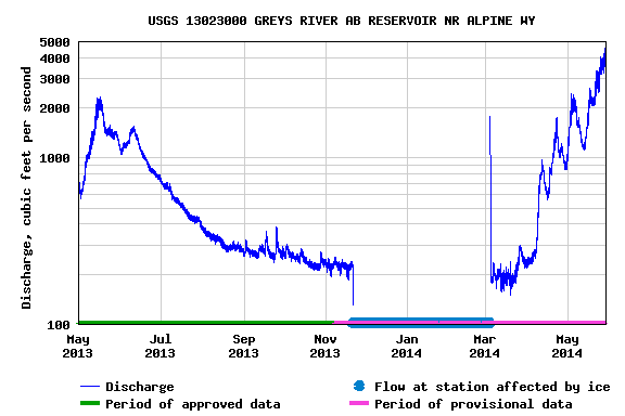
Thursday, May 8, 2014
Snow Melt Still Ahead
The Salt River has been running above normal levels the past few days

Examining the remaining snow pack at Willow Creek SNOTEL in the Salt Range, most of the snowmelt is yet to occur.

Much of the drainage basins in Idaho, Wyoming and Montana continue to report an above to well above normal snow pack.
 |
 |
 |
Fremont County Tornado May 6 2014
 |
| Fremont County Tornado May 6 2014 |
A weak tornado occurred Tuesday afternoon in Fremont County. Riverton Forecast Office has provided a summary about the tornado at the following link
Fremont County Tornado
Storm Totals Through Wednesday Afternoon
A late spring storm has impacted portions of central and western Wyoming Tuesday and Wednesday. A cold front became stationary across southern portions on Tuesday, allowing for cool, moist air at the surface across central portions. South of the front, warmer and drier conditions existed across southern portions, including Sweetwater and portions of Lincoln County. Southerly winds aloft brought warmer air across the state, allowing for destabilization to create showers and thunderstorms. Some thunderstorms became severe Tuesday afternoon, with hail of 0.25" to 1" being the main threats. As storms weakened overnight Tuesday, precipitation continued across the forecast area, with northern and central portions changing over to snow by sunrise Wednesday.

PUBLIC INFORMATION STATEMENT
NATIONAL WEATHER SERVICE RIVERTON WY
134 PM MDT WED MAY 7 2014

A COLD PACIFIC STORM SYSTEM HAS BROUGHT MOISTURE AND COLD AIR ACROSS
THE COWBOY STATE TUESDAY INTO WEDNESDAY. RAIN CHANGED OVER TO SNOW
ACROSS MANY LOCATIONS WEDNESDAY MORNING...WITH LOWER ELEVATIONS
ONLY REACHING A TRACE TO 2 INCHES. BELOW ARE
24 HOUR RAINFALL TOTALS ACROSS THE FORECAST AREA THROUGH 1PM.
LOCATION                       AMOUNT
TIME/DATE
...STAR VALLEY...05/07 AFTON (6267 FT) 0.31 IN 1259 PM 05/07 AFTON - COOP (6245 FT) 0.24 IN 0800 AM 05/07 BEDFORD - COOP (6425 FT) 0.22 IN 0700 AM 05/07 1 SE THAYNE (6086 FT) 0.18 IN 0700 AM 05/07 4 NE THAYNE (6217 FT) 0.18 IN 1246 PM 05/07 ETNA (5823 FT) 0.18 IN 1254 PM 05/07 3 NW ETNA (5692 FT) 0.15 IN 0100 PM 05/07 THAYNE (5928 FT) 0.15 IN 1255 PM 05/07 6 S ALPINE (5676 FT) 0.11 IN 1230 PM 05/07 1 NW AFTON (6211 FT) 0.01 IN 1200 PM
...SALT RIVER AND WYOMING RANGES...
05/07 28 WNW BIG PINEY (8500 FT)     0.60 IN   1200 PM
05/07 SALT RIVER SUMMIT (7600 FT)    0.60 IN   1100 AM
05/07 20 NE COKEVILLE (9425 FT)      0.60 IN   1200 PM
05/07 15 SE SMOOT (9000 FT)          0.50 IN   1200 PM
05/07 6 ENE SMOOT (7600 FT)          0.40 IN   1200 PM
05/07 SNIDER BASIN (8060 FT)         0.40 IN   1200 PM
05/07 8 NE AFTON (8450 FT)           0.40 IN   1200 PM
05/07 15 NE COKEVILLE (8180 FT)      0.40 IN   1200 PM
05/07 15 E COKEVILLE (7840 FT)       0.40 IN   1200 PM
05/07 13 E COKEVILLE (7460 FT)       0.37 IN   1130 AM
05/07 BLIND BULL SUMMIT (8900 FT)    0.30 IN   1200 PM
05/07 SMITHS FORK NEAR BORDER        0.27 IN   1230 PM
05/07 21 W BIG PINEY (8200 FT)       0.23 IN   1209 PM


...SOUTH LINCOLN COUNTY...
05/07 COKEVILLE (6191 FT)            0.25 IN   0106 PM
05/07 KEMMERER (6980 FT)             0.11 IN   1200 PM
05/07 9 N KEMMERER (7129 FT)         0.08 IN   0105 PM
...ABSAROKA MOUNTAINS...
05/07 17 SW MEETEETSE (7950 FT)      1.40 IN   1100 AM
05/07 18 SW CODY (8760 FT)           1.10 IN   1100 AM
05/07 17 NE DUBOIS (8400 FT)         1.00 IN   1100 AM
05/07 KIRWIN SNOTEL (9550 FT)        0.90 IN   1100 AM
05/07 12 SE PAHASKA (9780 FT)        0.50 IN   1100 AM
05/07 N ABSAROKA MTS (7650 FT)       0.50 IN   1100 AM
05/07 14 NE PAHASKA (9200 FT)        0.40 IN   1100 AM
05/07 BEARTOOTH LAKE (9275 FT)       0.40 IN   1100 AM
05/07 19 SSW WAPITI (6200 FT)        0.39 IN   1200 PM
05/07 PAHASKA (6696 FT)              0.36 IN   0700 AM
05/07 CHIEF JOSEPH HWY MILE 9        0.28 IN   1212 PM
05/07 3 E PAHASKA (7500 FT)          0.24 IN   1257 PM
05/07 PAHASKA (6800 FT)              0.18 IN   1200 PM
05/07 16 WSW GRASS CREEK (2414 FT)   0.12 IN   1206 PM
05/07 39 W THERMOPOLIS (8975 FT)     0.10 IN   1100 AM
05/07 10 WNW CODY (8401 FT)          0.09 IN   1240 PM
05/07 10 N DUBOIS (8085 FT)          0.01 IN   1257 PM


...BIGHORN MOUNTAINS SOUTHEAST...
05/07 14 WSW STORY (8870 FT)         1.10 IN   1100 AM
05/07 7 WSW BUFFALO (5745 FT)        0.98 IN   1200 PM
05/07 CLOUD PEAK (9860 FT)           0.90 IN   1100 AM
05/07 15 W BUFFALO (8720 FT)         0.90 IN   1100 AM
05/07 15 WSW BUFFALO (8360 FT)       0.70 IN   1100 AM
05/07 14 W BUFFALO (8400 FT)         0.32 IN   1200 PM
05/07 18 NW BUFFALO (8604 FT)        0.28 IN   1247 PM
05/07 7 NW MAYOWORTH (5720 FT)       0.27 IN   1200 PM
05/07 20 NW MAYOWORTH (8180 FT)      0.20 IN   1200 PM
05/07 14 WNW MAYOWORTH (8200 FT)     0.10 IN   1100 AM
05/07 7 SW BARNUM (6440 FT)          0.09 IN   1246 PM
05/07 16 SE BIG TRAILS (7220 FT)     0.06 IN   1200 PM
05/07 18 WNW BUFFALO (8580 FT)       0.03 IN   1145 AM


...BIGHORN MOUNTAINS WEST...
05/07 5 ENE HYATTVILLE (5670 FT)     0.61 IN   1252 PM
05/07 5 NW GRANITE PASS (9350 FT)    0.60 IN   1100 AM
05/07 12 ENE TEN SLEEP (8202 FT)     0.52 IN   1214 PM
05/07 BALD MTN. (9380 FT)            0.50 IN   1100 AM
05/07 POWDER RIVER PASS (9480 FT)    0.40 IN   1100 AM
05/07 17 E SHELL (9580 FT)           0.30 IN   1100 AM
05/07 30 E GREYBULL (8898 FT)        0.24 IN   1258 PM
05/07 S. BIGHORN MTS (6554 FT)       0.17 IN   1240 PM
05/07 30 SE TEN SLEEP (7760 FT)      0.10 IN   1100 AM


...CASPER MOUNTAIN...
05/07 CASPER MTN (7850 FT)           0.40 IN   1200 PM
05/07 4 SSW CASPER (6262 FT)         0.31 IN   0700 AM
05/07 22 SE CASPER (8500 FT)         0.20 IN   1200 PM


...CODY FOOTHILLS...
05/07 6 SW MEETEETSE (6238 FT)       0.76 IN   0700 AM
05/07 1 ESE CODY (5088 FT)           0.41 IN   0716 AM
05/07 1 WNW CODY (4929 FT)           0.28 IN   0800 AM
05/07 CODY AIRPORT (5100 FT)         0.24 IN   0555 AM
05/07 3 SW RALSTON (4575 FT)         0.24 IN   1245 PM
05/07 3 NE CLARK (4090 FT)           0.20 IN   0800 AM
05/07 MEETEETSE (5797 FT)            0.16 IN   0104 PM
05/07 WAPITI (5400 FT)               0.13 IN   1215 PM
05/07 BUFFALO BILL RESERVOIR         0.12 IN   1245 PM
05/07 5 WNW CLARK (4659 FT)          0.07 IN   1259 PM
05/07 1 W CLARK (4270 FT)            0.01 IN   0106 PM


...GREEN MOUNTAINS AND RATTLESNAKE RANGE...
05/07 16 S HILAND (6380 FT)          0.04 IN   1210 PM


...JACKSON HOLE...
05/07 7 E MORAN JCT (7251 FT)        0.39 IN   1252 PM
05/07 JACKSON HOLE AIRPORT (6445 FT) 0.34 IN   0555 AM
05/07 JACKSON (6240 FT)              0.29 IN   1145 AM
05/07 4 N MOOSE (6730 FT)            0.28 IN   1258 PM
05/07 JACKSON - COOP (6210 FT)       0.28 IN   0900 AM
05/07 SNAKE RIVER AT JACKSON LAKE DA 0.27 IN   1130 AM
05/07 1 ENE MOOSE (6496 FT)          0.27 IN   0700 AM
05/07 4 SW JACKSON (6073 FT)         0.27 IN   0103 PM
05/07 MORAN JUNCTION (6749 FT)       0.26 IN   0104 PM
05/07 3 SSW JACKSON (6158 FT)        0.25 IN   0101 PM
05/07 MOOSE - COOP (6445 FT)         0.25 IN   0800 AM
05/07 JACKSON (6247 FT)              0.24 IN   0102 PM
05/07 HOBACK JUNCTION (5928 FT)      0.23 IN   0102 PM
05/07 2 ENE WILSON (6184 FT)         0.19 IN   0103 PM
05/07 5 S OF SOUTH ENTRANCE YNP      0.16 IN   1130 AM


...LANDER FOOTHILLS...
05/07 MIDDLE FORK POPO AGIE RIVER    0.76 IN   1215 PM
05/07 1 WSW LANDER (1662 FT)         0.70 IN   0900 AM
05/07 7 NW LANDER (5797 FT)          0.69 IN   1256 PM
05/07 4 W MILFORD (6042 FT)          0.52 IN   0700 AM
05/07 4 SW LANDER (5807 FT)          0.51 IN   0100 PM
05/07 9 SSE LANDER (5796 FT)         0.50 IN   0700 AM
05/07 1 WSW LANDER (5435 FT)         0.46 IN   0700 AM
05/07 LANDER AIRPORT (5586 FT)       0.44 IN   0553 AM
05/07 LANDER (5320 FT)               0.43 IN   0655 AM
05/07 9 SSE LANDER (5818 FT)         0.32 IN   0700 AM


...NATRONA COUNTY LOWER ELEVATIONS...
05/07 MIDWEST (4860 FT)              0.30 IN   0700 AM
05/07 1 SSW CASPER (5410 FT)         0.23 IN   0700 AM
05/07 1 SW CASPER (5315 FT)          0.23 IN   0800 AM
05/07 MIDWEST (4865 FT)              0.19 IN   1258 PM
05/07 3 SW MILLS (5151 FT)           0.14 IN   0700 AM
05/07 CASPER (1567 FT)               0.12 IN   0700 AM
05/07 CASPER - N PLATTE RIVER        0.07 IN   1230 PM
05/07 CASPER - COOP (5180 FT)        0.07 IN   0700 AM
05/07 MILLS (5150 FT)                0.07 IN   1200 PM
05/07 8 WSW MILLS (5277 FT)          0.06 IN   0700 AM
05/07 CASPER AIRPORT (5320 FT)       0.01 IN   0553 AM


...NORTH BIG HORN BASIN...
05/07 GREYBULL (3860 FT)             0.54 IN   1028 AM
05/07 BASIN (3897 FT)                0.43 IN   0102 PM
05/07 BASIN (3821 FT)                0.42 IN   1215 PM
05/07 BASIN (3884 FT)                0.38 IN   1249 PM
05/07 2 E RALSTON (4485 FT)          0.24 IN   0700 AM
05/07 DEAVER - COOP (4105 FT)        0.21 IN   0800 AM
05/07 GREYBULL (3769 FT)             0.18 IN   0700 AM
05/07 3 W POWELL (4505 FT)           0.18 IN   0850 AM
05/07 2 N FRANNIE (4275 FT)          0.18 IN   0105 PM
05/07 LOVELL (3830 FT)               0.17 IN   0101 PM
05/07 1 WNW POWELL (4386 FT)         0.15 IN   0100 PM
05/07 GREYBULL AIRPORT (3935 FT)     0.13 IN   0553 AM
05/07 SHELL (4285 FT)                0.12 IN   0556 AM
05/07 1 W POWELL (4462 FT)           0.10 IN   0105 PM
05/07 11 ESE LOVELL (3660 FT)        0.07 IN   1215 PM


...NORTHEAST JOHNSON COUNTY...
05/07 8 ENE BUFFALO (4370 FT)        0.76 IN   0105 PM
05/07 8 S STORY (5280 FT)            0.74 IN   1200 PM
05/07 BUFFALO (4635 FT)              0.51 IN   0500 AM
05/07 BUFFALO AIRPORT (4970 FT)      0.51 IN   0553 AM


...OWL CREEK AND BRIDGER MOUNTAINS...
05/07 10 S MEETEETSE (7127 FT)       0.21 IN   1242 PM


...ROCK SPRINGS AND GREEN RIVER...
05/07 GREEN RIVER (6133 FT)          0.05 IN   0700 AM


...SOUTHEAST BIG HORN BASIN...
05/07 TENSLEEP (4680 FT)             0.48 IN   0700 AM
05/07 TEN SLEEP (1349 FT)            0.46 IN   0607 AM
05/07 5 NNW TEN SLEEP (4531 FT)      0.36 IN   0700 AM
05/07 WORLAND (4060 FT)              0.35 IN   0700 AM
05/07 WORLAND AIRPORT (4245 FT)      0.23 IN   0553 AM
05/07 TEN SLEEP (4470 FT)            0.23 IN   1258 PM


...SOUTHEAST JOHNSON COUNTY...
05/07 10 SW KAYCEE (4900 FT)         0.20 IN   1200 PM
05/07 3 SSE BARNUM (5075 FT)         0.16 IN   1200 PM
05/07 KAYCEE (4681 FT)               0.11 IN   1257 PM
05/07 17 E KAYCEE (4362 FT)          0.10 IN   1215 PM


...SOUTHWEST BIG HORN BASIN...
05/07 KIRBY (4328 FT)                0.44 IN   0632 AM
05/07 THERMOPOLIS 9 NE (4280 FT)     0.41 IN   0500 AM


...TETON AND GROS VENTRE MOUNTAINS...
05/07 8 W SOUTH ENTRANCE YNP         0.60 IN   1200 PM
05/07 2 NE TETON PASS (8200 FT)      0.50 IN   1200 PM
05/07 TOGWOTEE PASS (9850 FT)        0.50 IN   1200 PM
05/07 8 NNE MORAN JUNCTION (7030 FT) 0.40 IN   1200 PM
05/07 14 E BONDURANT (8240 FT)       0.40 IN   1200 PM
05/07 32 ESE JACKSON (8750 FT)       0.40 IN   1200 PM
05/07 GRAND TARGHEE (9260 FT)        0.40 IN   1200 PM
05/07 15 NNE GRAND TARGHEE (6830 FT) 0.16 IN   1203 PM
05/07 10 N BONDURANT (6770 FT)       0.10 IN   1200 PM
05/07 ALTA (6430 FT)                 0.05 IN   1145 AM


...UPPER GREEN RIVER BASIN...
05/07 MARBLETON (6896 FT)            0.41 IN   1257 PM
05/07 BIG PINEY AIRPORT (6974 FT)    0.25 IN   0553 AM
05/07 9 E BIG PINEY (6803 FT)        0.20 IN   1200 PM
05/07 22 NNE GRANGER (6322 FT)       0.09 IN   0103 PM
05/07 1 S FONTENELLE RESERVOIR       0.03 IN   1200 PM


...UPPER GREEN RIVER BASIN FOOTHILLS...
05/07 EAST RIM DIVIDE (7930 FT)      0.50 IN   1100 AM
05/07 PINEDALE (7310 FT)             0.43 IN   1200 PM
05/07 2 NW BONDURANT (6726 FT)       0.42 IN   1251 PM
05/07 BONDURANT (6650 FT)            0.28 IN   1200 PM
05/07 DANIEL FISH HATCHERY - COOP    0.18 IN   0800 AM
05/07 10 NNW DANIEL (7470 FT)        0.14 IN   1130 AM
05/07 BOULDER REARING STATION - COOP 0.08 IN   0800 AM


...UPPER WIND RIVER BASIN...
05/07 DUBOIS (6955 FT)               0.65 IN   0600 AM
05/07 11 W CROWHEART (6520 FT)       0.60 IN   1145 AM
05/07 CROWHEART (6099 FT)            0.51 IN   1258 PM
05/07 BURRIS (6120 FT)               0.40 IN   0630 AM
05/07 1 WNW DUBOIS (7014 FT)         0.20 IN   0101 PM
05/07 6 NW DUBOIS (7189 FT)          0.08 IN   1215 PM


...WIND RIVER BASIN...
05/07 3 E FORT WASHAKIE (5528 FT)    0.86 IN   0105 PM
05/07 10 SE CROWHEART (5654 FT)      0.55 IN   1200 PM
05/07 HUDSON (5090 FT)               0.48 IN   0650 AM
05/07 RIVERTON FORECAST OFFICE       0.34 IN   0555 AM
05/07 2 S RIVERTON (4901 FT)         0.30 IN   1215 PM
05/07 RIVERTON (4950 FT)             0.26 IN   0700 AM
05/07 RIVERTON AIRPORT (5525 FT)     0.23 IN   0553 AM
05/07 11 NE RIVERTON (5016 FT)       0.22 IN   0103 PM
05/07 1 ESE RIVERTON (4980 FT)       0.20 IN   0800 AM


...WIND RIVER MOUNTAINS EAST...
05/07 13 W CROWHEART (9630 FT)       1.10 IN   1100 AM
05/07 13 W FORT WASHAKIE (8620 FT)   0.80 IN   1100 AM
05/07 18 W LANDER (10100 FT)         0.60 IN   1100 AM
05/07 5 WSW DUBOIS (9370 FT)         0.60 IN   1100 AM
05/07 9 SW LANDER (7085 FT)          0.46 IN   1200 PM
05/07 10 W FORT WASHAKIE (9235 FT)   0.22 IN   1201 PM
05/07 12 SW LANDER (8700 FT)         0.10 IN   1100 AM
05/07 10 W DUBOIS (8432 FT)          0.01 IN   0100 PM


...WIND RIVER MOUNTAINS WEST...
05/07 N WIND RIVER MTS (9820 FT)     0.80 IN   1200 PM
05/07 10 E BIG SANDY (9080 FT)       0.60 IN   1200 PM
05/07 PINE CREEK ABOVE FREMONT LAKE  0.57 IN   1245 PM
05/07 20 E BONDURANT (7740 FT)       0.50 IN   1200 PM
05/07 17 NW SOUTH PASS CITY          0.50 IN   1200 PM
05/07 NEW FORK LAKE (8340 FT)        0.50 IN   1200 PM
05/07 16 E BOULDER (9360 FT)         0.50 IN   1200 PM
05/07 BOULDER LAKE (7350 FT)         0.31 IN   1200 PM
05/07 7 NE PINEDALE (8530 FT)        0.30 IN   1226 PM
05/07 15 N PINEDALE (9400 FT)        0.30 IN   1200 PM
05/07 N WIND RIVER MTS (8833 FT)     0.10 IN   1210 PM


...YELLOWSTONE NATIONAL PARK...
05/07 SE YELLOWSTONE (9240 FT)       0.70 IN   1200 PM
05/07 6 S LEWIS LAKE IN YNP          0.70 IN   1200 PM
05/07 PARKER PEAK (E. YNP) (9400 FT) 0.50 IN   1100 AM
05/07 SYLVAN LAKE (8420 FT)          0.40 IN   1200 PM
05/07 4 W PAHASKA (7120 FT)          0.40 IN   1100 AM
05/07 EAST ENTRANCE YELLOWSTONE NP - 0.33 IN   0800 AM
05/07 LAMAR RANGER STATION (6555 FT) 0.33 IN   0800 AM
05/07 OLD FAITHFUL (7320 FT)         0.32 IN   1215 PM
05/07 YELLOWSTONE LAKE (7835 FT)     0.32 IN   0556 AM
05/07 OLD FAITHFUL (7360 FT)         0.31 IN   0800 AM
05/07 2 S GRANT VILLAGE (7980 FT)    0.30 IN   1200 PM
05/07 1 NNE LAKE (7875 FT)           0.29 IN   1200 PM
05/07 4 W SOUTH ENTRANCE YNP         0.23 IN   1130 AM
05/07 14 S SYLVAN PASS (8650 FT)     0.22 IN   1208 PM
05/07 SOUTH ENTRANCE YNP (6920 FT)   0.20 IN   1200 PM
05/07 EXTREME SW YELLOWSTONE         0.20 IN   1249 PM
05/07 TOWER FALLS (6266 FT)          0.16 IN   1215 PM
05/07 MAMMOTH (6300 FT)              0.13 IN   1215 PM
05/07 MAMMOTH  AT YELLOWSTONE NP - C 0.11 IN   0800 AM
05/07 1 SW CANYON (7900 FT)          0.11 IN   1249 PM
05/07 GARDNER RIVER NR MAMMOTH       0.10 IN   1245 PM
05/07 TANTALUS CREEK NEAR NORRIS JUN 0.10 IN   1230 PM
05/07 1 SW CANYON (8090 FT)          0.10 IN   1100 AM
05/07 SOUTH ENTRANCE YNP (6900 FT)   0.07 IN   1130 AM
05/07 14 WSW MAMMOTH (7900 FT)       0.07 IN   1249 PM
Saturday, May 3, 2014
Rivers are Rising in Western Wyoming
NATIONAL WEATHER SERVICE RIVERTON WY
946 AM MDT FRI MAY 2 2014

...SIGNIFICANT SNOWMELT RUNOFF ALONG CREEKS AND RIVERS EXPECTED
MONDAY AND TUESDAY...

CREEKS AND RIVERS ACROSS CENTRAL AND WESTERN WYOMING ARE EXPECTED
TO SEE SIGNIFICANT RISES BY NEXT MONDAY AND TUESDAY IN RESPONSE TO
ACTIVE SNOWMELT RUNOFF SATURDAY THROUGH MONDAY.

AFTERNOON TEMPERATURES AT THE 9000 FOOT ELEVATION ARE FORECAT ED
TO REACH INTO THE LOWER 50S SATURDAY AND SUNDAY. TEMPERATURES
AT THE 9000 FOOT ELEVATION ARE EXPECTED TO COOL DOWN INTO
THE MIDDLE TO UPPER 40S BY MONDAY AFTERNOON AND INTO THE
UPPER 30S BY TUESDAY AFTERNOON.

RAIN SHOWERS ARE EXPECTED OVER NORTHERN AND CENTRAL WYOMING
BEGINNING TUESDAY MORNING AND LASTING THROUGH THURSDAY NIGHT.
FLOWS ALONG CREEKS AND RIVERS MAY SEE ADDITIONAL RISES TUESDAY
AFTERNOON DUE TO RAIN ON SNOWMELT. SNOW LEVELS ARE EXPECTED TO
DROP TO NEAR 8000 FEET BY TUESDAY NIGHT...WHICH WILL STOP ACTIVE
SNOWMELT RUNOFF

MINOR LOW LAND FLOODING MAY OCCUR ALONG TRIBUTARY CREEKS AND
STREAMS MONDAY AFTERNOON THROUGH TUESDAY AFTERNOON.  MAINSTEM RIVERS
LIKE THE GREEN...WIND...AND SHOSHONE ARE EXPECTED TO SEE
SIGNIFICANT RISES AND FLOWS MONDAY AND TUESDAY...BUT NO FLOODING
IS EXPECTED.

IF YOU ARE IN MOUNTAINS SUNDAY THROUGH TUESDAY...DO NOT ATTEMPT
TO CROSS STREAMS AND CREEKS DURING THE LATE AFTERNOON AND EARLY
EVENING. CREEKS AND STREAMS WILL BE AT THEIR HIGHEST AT THOSE
TIMES.

VISIT WEATHER.GOV/RIVERTON AND SELECT THE RIVERS & LAKES TAB FOR
GRAPHICAL FORECASTS AND ADDITIONAL INFORMATION.
Friday, May 2, 2014
Serious Snowmelt Ahead
The threat of serious rises in the Wyoming Rivers this spring with the much above normal snowfall will be taking place the next several days as temperatures warm significantly. Here is the latest map of expected runoff for the river basins of western Wyoming. Note that the Star Valley area can expect a moderate risk of some flooding.
.png)
Along with the discussion of snowmelt the weekly weather video from Riverton Forecast Office highlights the very warm weather ahead for this weekend.
Western Wyoming Weekly Weather Video
Along with the discussion of snowmelt the weekly weather video from Riverton Forecast Office highlights the very warm weather ahead for this weekend.
Western Wyoming Weekly Weather Video
Subscribe to:
Posts (Atom)