Tuesday, November 25, 2014

Latest Snowfall Totals

NATIONAL WEATHER SERVICE RIVERTON WY
740 PM MST TUE NOV 25 2014

SNOW FELL ACROSS WESTERN AND CENTRAL WYOMING LAST
NIGHT AND THROUGH THE DAY INTO THIS EVENING.
HERE ARE SOME SNOWFALL REPORTS SO FAR. MANY MORE
REPORTS WILL COME IN WEDNESDAY MORNING.

LOCATION                             SNOWFALL

LINCOLN COUNTY...
 SPRING CREEK DIVIDE SNOTEL...       17 INCHES.
 ALPINE...                           15 INCHES.
 WILLOW CREEK SNOTEL...              14 INCHES.
 COTTONWOOD CREEK SNOTEL...          12 INCHES.
 SALT RIVER SUMMIT SNOTEL...         10 INCHES.
 BLIND BULL SUMMIT SNOTEL...         10 INCHES.
 INDIAN CREEK SNOTEL...               9 INCHES.
 KELLEY RANGER STATION SNOTEL...      7 INCHES.
 ALPINE...                            7 INCHES.
 STAR VALLEY RANCH...                 6 INCHES.
 AFTON...                             5 INCHES.
 HAMS FORK SNOTEL...                  5 INCHES.
 5 SSE SMOOT...                       4 INCHES.
 2 SE THAYNE...                     3.7 INCHES.
 BOX Y RANCH...                       3 INCHES.
 AFTON...                           2.1 INCHES.
 BLIND BULL SUMMIT...                 2 INCHES.
 COMMISSARY RIDGE...                  1 INCH.
 FOSSIL BUTTE...                    0.5 INCHES.
BIG HORN COUNTY...
 26 E LOVELL...                      11 INCHES.
 BALD MOUNTAIN SNOTEL...             10 INCHES.
 BONE SPRINGS DIVIDE SNOTEL...       10 INCHES.
 BASIN...                             9 INCHES.
 SHELL CREEK SNOTEL...                8 INCHES.
 COWLEY...                            8 INCHES.
 1 E GREYBULL...                    6.6 INCHES.
 LOVELL...                            6 INCHES.

FREMONT COUNTY...
 COLD SPRINGS SNOTEL...               5 INCHES.
 LITTLE WARM SNOTEL...                4 INCHES.
 CASTLE CREEK SNOTEL...               4 INCHES.
 BURROUGHS CREEK SNOTEL...            3 INCHES.
 BROOKS LAKE...                       3 INCHES.
 HOBBS PARK SNOTEL...                 1 INCH.

HOT SPRINGS COUNTY...
 OWL CREEK SNOTEL...                  1 INCH.

JOHNSON COUNTY...
 CLOUD PEAK RESERVOIR SNOTEL...       5 INCHES.
 BEAR TRAP MEADOW SNOTEL...           5 INCHES.
 HANSEN SAWMILL SNOTEL...             3 INCHES.
 BUFFALO...                         2.5 INCHES.
 SOLDIER PARK SNOTEL...               2 INCHES.
 LITTLE GOOSE SNOTEL...               2 INCHES.


NATRONA COUNTY...
 GRAVE SPRING SNOTEL...               3 INCHES.
 MIDWEST...                         0.5 INCHES.

PARK COUNTY...
 EVENING STAR SNOTEL...              13 INCHES.
 WOLVERINE SNOTEL...                 11 INCHES.
 BEARTOOTH LAKE SNOTEL...             9 INCHES.
 BLACKWATER SNOTEL...                 8 INCHES.
 FRANNIE...                           7 INCHES.
 WAPITI...                            6 INCHES.
 3 SW FRANNIE...                      5 INCHES.
 PAHASKA...                           5 INCHES.
 MARQUETTE SNOTEL...                  4 INCHES.
 KIRWIN SNOTEL...                     3 INCHES.
 1 W POWELL...                      1.5 INCHES.
 TIMBER CREEK SNOTEL...               1 INCH.

SUBLETTE COUNTY...
 TRIPLE PEAK SNOTEL...               10 INCHES.
 EAST RIM DIVIDE SNOTEL...            9 INCHES.
 SNIDER BASIN SNOTEL...               9 INCHES.
 LOOMIS PARK SNOTEL...                7 INCHES.
 NEW FORK LAKE SNOTEL...              5 INCHES.
 PINEDALE...                          4 INCHES.
 GUNSITE PASS SNOTEL...               4 INCHES.
 KENDALL RANGER STATION SNOTEL...     4 INCHES.
 ELKHART PARK G.S. SNOTEL...          3 INCHES.
 POCKET CREEK SNOTEL...               3 INCHES.
 BIG SANDY OPENING SNOTEL...          3 INCHES.
 15 WNW DANIEL...                   1.8 INCHES.
 DANIEL FISH HATCHERY...              1 INCH.
 LARSEN CREEK SNOTEL...               1 INCH.
 14 NW PINEDALE...                    1 INCH.

TETON COUNTY...
 GRAND TARGHEE SNOTEL...             20 INCHES.
 PHILLIPS BENCH SNOTEL...            20 INCHES.
 TOGWOTEE MOUNTAIN LODGE...          14 INCHES.
 BASE CAMP SNOTEL...                 13 INCHES.
 JACKSON HOLE-RENDEZVOUS BOWL...     13 INCHES.
 TOGWOTEE PASS SNOTEL...             12 INCHES.
 JACKSON HOLE-MID...                 12 INCHES.
 SNAKE RIVER STN SNOTEL...           10 INCHES.
 GRANITE CREEK SNOTEL...             10 INCHES.
 JACKSON HOLE-RAYMER...              10 INCHES.
 TOGWOTEE PASS...                     9 INCHES.
 12 NE JACKSON...                     7 INCHES.
 JACKSON...                      5 TO 6 INCHES.
 MOOSE...                             6 INCHES.
 JACKSON DAM...                     5.5 INCHES.
 5 NW JACKSON...                    4.5 INCHES.
 3 SSW WILSON...                      4 INCHES.
 GRAND TARGHEE-CHIEF JOSEPH...        4 INCHES.
 2 NE TETON VILLAGE...                3 INCHES.
 JACKSON HOLE-BASE...                 3 INCHES.
 SNOW KING...                         1 INCH.
 GROS VENTRE SUMMIT SNOTEL...         1 INCH.

WASHAKIE COUNTY...
 POWDER RIVER PASS SNOTEL...          8 INCHES.
 MIDDLE POWDER SNOTEL...              3 INCHES.

YELLOWSTONE NATIONAL PARK...
 SYLVAN ROAD SNOTEL...                9 INCHES.
 TWO OCEAN PLATEAU SNOTEL...          8 INCHES.
 SYLVAN LAKE SNOTEL...                6 INCHES.
 CANYON SNOTEL...                     6 INCHES.
 PARKER PEAK SNOTEL...                5 INCHES.
 OLD FAITHFUL RANGER STATION...     4.5 INCHES.
 THUMB DIVIDE SNOTEL...               4 INCHES.
 YELLOWSTONE EAST ENTRANCE...         4 INCHES.
 LEWIS LAKE DIVIDE SNOTEL...          4 INCHES.
 TOWER FALLS RANGER STATION...      2.5 INCHES.
 LAMAR RANGER STATION...              2 INCHES.


...HERE ARE PEAK WIND SPEEDS THAT OCCURRED LAST
NIGHT AND TODAY ACROSS REGION...

LOCATION                       SPEED     TIME/DATE

...WYOMING...

...FREMONT...
7 SW MUDDY GAP (7380 FT)       74 MPH    0550 AM 11/25
2 W SOUTH PASS CITY (8185 FT)  57 MPH    0511 AM 11/25
10 W FORT WASHAKIE (9235 FT)   57 MPH    0501 AM 11/25
10 N DUBOIS (8085 FT)          49 MPH    0357 AM 11/25
DUBOIS (6980 FT)               47 MPH    0657 AM 11/25
11 NE RIVERTON (5016 FT)       44 MPH    0113 PM 11/25
RIVERTON AIRPORT (5525 FT)     43 MPH    1106 PM 11/24
8 W SOUTH PASS CITY (8120 FT)  43 MPH    0550 AM 11/25
BEAVER RIM (6784 FT)           41 MPH    0556 AM 11/25
CROWHEART (6099 FT)            40 MPH    1126 PM 11/24

...JOHNSON...
BUFFALO AIRPORT (4970 FT)      49 MPH    0356 PM 11/25
5 ESE STORY (4673 FT)          45 MPH    0346 PM 11/25
13 NNW BUFFALO (4737 FT)       44 MPH    0115 PM 11/25
7 SW BARNUM (6440 FT)          44 MPH    0646 AM 11/25

...LINCOLN...
KEMMERER AIRPORT (7285 FT)     55 MPH    0235 PM 11/25
13 W KEMMERER (6718 FT)        45 MPH    1225 PM 11/25
9 N KEMMERER (7129 FT)         43 MPH    0117 PM 11/25

...NATRONA...
16 S HILAND (6380 FT)          45 MPH    0910 AM 11/25
CASPER AIRPORT (5320 FT)       43 MPH    0554 AM 11/25

...PARK...
5 WNW CLARK (4659 FT)          92 MPH    0410 AM 11/25
CHIEF JOSEPH HWY (8136 FT)     60 MPH    1230 AM 11/25
CODY AIRPORT (5100 FT)         56 MPH    1215 AM 11/25
1 W CLARK (4270 FT)            49 MPH    0348 AM 11/25
10 WNW CODY (8401 FT)          47 MPH    0340 AM 11/25
3 E PAHASKA (7500 FT)          46 MPH    1157 AM 11/25
8 N MEETEETSE (5926 FT)        46 MPH    0141 PM 11/25
1 WNW POWELL (4386 FT)         44 MPH    0545 AM 11/25
3 W POWELL (4505 FT)           41 MPH    0548 AM 11/25

...SUBLETTE...
21 W BIG PINEY (8200 FT)       56 MPH    1209 AM 11/25

...SWEETWATER...
15 SE ROCK SPRINGS (7550 FT)   59 MPH    0944 AM 11/25
I 80 - MILE MARKER 142         53 MPH    0100 PM 11/25
I 80 - MILE MARKER 157         52 MPH    0140 PM 11/25
7 WSW ROCK SPRINGS (6238 FT)   50 MPH    0140 PM 11/25
5 E ROCK SPRINGS (6369 FT)     49 MPH    0620 AM 11/25
MCKINNON (7086 FT)             49 MPH    1031 AM 11/25
22 NNE GRANGER (6322 FT)       49 MPH    1058 AM 11/25
ROCK SPRINGS AIRPORT (6760 FT) 48 MPH    0812 AM 11/25
I 80 - MILE MARKER 124         46 MPH    1256 PM 11/25
7 WNW GREEN RIVER (6387 FT)    46 MPH    0132 PM 11/25
I 80 - MILE MARKER 184         45 MPH    0256 PM 11/25
1 NNE GREEN RIVER (6315 FT)    45 MPH    1252 PM 11/25
I 80 - MILE MARKER 131         43 MPH    0225 PM 11/25
FARSON (6594 FT)               41 MPH    0150 PM 11/25

...TETON...
SUMMIT - JACKSON RESORT        61 MPH    0930 AM 11/25

Monday, November 24, 2014

More Snow for Star Valley and Probably Some Rain

The recent storm dropped from 4 to 8 inches of snow across Star Valley with upwards to a foot or more in the nearby mountains.  A very moist air mass is heading toward Western Wyoming  from the Pacific in a strong northwesterly flow.  This can be seen on this Monday evenings water vapor image

Water Vapor Image Monday evening Nov 24 2014
\
While it is a generally mild air mass, snow will continue to be the predominant precipitation type in the mountains, with the snow becoming mixed with rain at times in the valleys during the day on Tuesday.

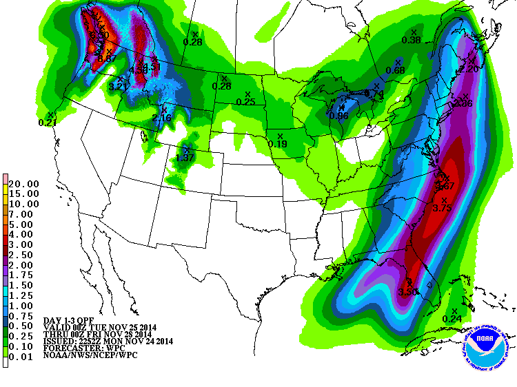
The forecasters at the Weather Prediction Center of the NWS  are predicting substantial  precipitation amounts over much of the mountains of the Northwest States.

Three day total of precipitation ending  Thursday evening November 27 2014
A detailed forecast for snow totals over the next 3 days  across Wyoming display the large differences dependent on the relationship with the higher terrain.

3 day forecast snow totals ending Thanksgiving evening November 27 2014.

Of interest will be the strong winds over and on the east side of the mountains in the down slope flow during the day, Tuesday.


.

Sunday, November 23, 2014

Snowfall Totals and Peak Wind Nov 22 2014


Riverton Forecast Office has compiled the storm  totals for the storm on Saturday 22 2014
CountyStation NameSnowfall
LincolnCommissary Ridge18
LincolnWillow Creek Snotel13
LincolnSpring Creek Divide Snotel13
LincolnCottonwood Creek Snotel11
LincolnBlind Bull Summit10
LincolnIndian Creek Snotel10
Lincoln5 SSE Smoot9
LincolnKelley Ranger Station Snotel9
Lincoln3 SE Bedford8
LincolnBox Y Ranch8
LincolnHams Fork Snotel7
LincolnSalt River Summit Snotel6
Lincoln2 SE Thayne5
LincolnAlpine5
LincolnAfton3.4
LincolnCokeville3
LincolnStar Valley Ranch2
LincolnFossil Butte2.5
BigHorn


Big HornBald Mountain Snotel1
FremontDeer Park Snotel8
FremontBurroughs Creek Snotel8
FremontBrooks Lake Lodge8
FremontSouth Pass Snotel6
FremontBrooks Lake5
FremontAtlantic City5
FremontHobbs Park Snotel4
FremontCastle Creek Snotel3
FremontLittle Warm Snotel3
FremontCold Springs Snotel2
FremontSt. Lawrence Alt Snotel2
FremontDubois1


NatronaCasper Mountain2
ParkBeartooth Lake Snotel8
ParkKirwin Snotel5
ParkEvening Star Snotel4
ParkWolverine Snotel3
ParkBlackwater Snotel2
ParkPahaska2
ParkMarquette Snotel1
ParkTimber Creek Snotel1
SubletteTriple Peak Snotel12
SubletteLarsen Creek Snotel8
SubletteLoomis Park Snotel8
SubletteSnider Basin Snotel7
SubletteKendall Ranger Station Snotel7
Sublette14 NW Pinedale5.8
SublettePocket Creek Snotel5
SubletteNew Fork Lake Snotel5
SubletteBig Sandy Opening Snotel5
SubletteElkhart Park G.S. Snotel4
SubletteEast Rim Divide Snotel4
SublettePinedale3.8
SubletteGunsite Pass Snotel2
SubletteBoulder Rearing Station2
SweetwaterRock Springs1
TetonJackson Hole-Raymer13
TetonJackson Hole-Rendezvous Bowl13
TetonJackson Hole-Mid12
TetonGranite Creek Snotel12
TetonPhillips Bench Snotel11
TetonBase Camp Snotel11
TetonGrand Targhee Snotel11
Teton3 SSW Wilson9.7
Teton2 NE Teton Village9
TetonGrassy Lake Snotel8
Teton5 NW Jackson7.5
Teton9 SW Jackson6
TetonGrand Targhee-Chief Joseph6
TetonTogwotee Pass Snotel6
TetonGros Ventre Summit Snotel6
TetonSnake River Stn Snotel5
TetonTogwotee Mountain Lodge5
Teton1 NNW Alta4
TetonJackson Hole-Base4
TetonJackson4
TetonMoose3.5
Teton12 NE Jackson3
Teton3 NNE Wilson3
TetonDarwin Ranch2.9
Teton2 SW Wilson2.7
Teton1 ENE Teton Village2.5
TetonSnow King2
WashakiePowder River Pass Snotel3
YellowstoneLewis Lake Divide Snotel11
YellowstoneTwo Ocean Plateau Snotel7
YellowstoneOld Faithful Ranger Station4
YellowstoneSylvan Road Snotel3
YellowstoneCanyon Snotel3
YellowstoneThumb Divide Snotel2
YellowstoneSylvan Lake Snotel2
YellowstoneYellowstone East Entrance1.5
YellowstoneLamar Ranger Station1


Strongest Wind Banner

Saturday, November 22nd, Highest Wind Gusts
CountyLocation and ElevationWind Gust (mph)
 Fremont  7 SW Muddy Gap (7380 ft)84 
 Fremont Red Canyon (6768 ft) 75
 Fremont Dubois (6980 ft)55
 Fremont Beaver Rim (6784 ft) 54
 Fremont 2 W South Pass City (8185 ft) 53
 Fremont 7 NW Lander (5797 ft)49
 Fremont Lander Airport (5585 ft) 46
 Fremont 10 W Fort Washakie (9235 ft)45 
 Hot Springs  Boysen Reservoir (7300 ft)53
 Hot Springs 10 S Meeteetse (7127 ft) 51
 Johnson 7 SW Barnum (6440 ft)61 
 Johnson 12 N Kaycee (5287 ft)  50
 Johnson Buffalo Airport (4970 ft) 45
 Lincoln Kemmerer Airport (7285 ft)54 
 Lincoln 4 E Sage Junction (6387 ft) 47
 Natrona 10 S Hiland (6380 ft) 80
 Natrona Casper - Outer Drive 76
 Natrona Casper Airport (5320 ft) 58
 Natrona 2 SE Hiland (6134 ft) 55
 Natrona 19 N Casper (5667 ft) 50
 Natrona 1 E Casper (5334 ft) 48
 Natrona 7 W Alcova (6342 ft) 45
 Natrona 8 S Casper (7740 ft) 45
 Park 5 WNW Clark (4659 ft)103 
 Park Chief Joseph Highway (8136 ft)85 
 Park 10 WNW Cody (8401 ft) 72
 Park 1 W Clark (4270 ft) 58
 Park 3 W Powell (4505 ft) 51
 Park 3 E Pahaska (7500 ft) 50
 Park 8 N Meeteetse (5926 ft) 49
 Park Cody Airport (5100 ft) 49
 Park 14 S Sylvan Pass (8650 ft) 48
 Sweetwater Rock Springs Airport (6760 ft) 60
 Sweetwater 7 WSW Rock Springs (6238 ft) 47
 Sweetwater 5 E Rock Springs (6369 ft) 47
 Sweetwater 1 NNE Green River (6315 ft) 47
 Sweetwater 22 NNE Granger (6322 ft) 45
 Teton Summet - Jackson Resort (10,450 ft) 54


Friday, November 21, 2014

Winter Storm Warning Star Valley!

The Riverton Forecast Office has issued a Winter Storm Warning for Star Valley.

URGENT - WINTER WEATHER MESSAGE
NATIONAL WEATHER SERVICE RIVERTON WY
902 PM MST FRI NOV 21 2014

...SNOW AND BLOWING SNOW ACROSS THE WESTERN MOUNTAINS AND VALLEYS
SATURDAY AND SATURDAY NIGHT...

.SNOW WILL INCREASE ACROSS WESTERN WYOMING AHEAD OF AN APPROACHING
COLD FRONT SATURDAY MORNING. THE COLD FRONT WILL PUSH ACROSS
WESTERN WYOMING SATURDAY AFTERNOON ACCOMPANIED BY MODERATE TO
HEAVY SNOWFALL AND STRONG RIDGE TOP WINDS. NUMEROUS SNOW SHOWERS
WILL PERSIST BEHIND THE FRONT SATURDAY NIGHT ALONG WITH GUSTY
NORTHWEST WIND AT RIDGE TOP LEVEL CAUSING AREAS OF BLOWING AND
DRIFTING SNOW.

WYZ012-013-023-221215-
/O.CON.KRIW.WS.W.0013.141122T0700Z-141123T1300Z/
TETON AND GROS VENTRE MOUNTAINS-JACKSON HOLE-STAR VALLEY-
INCLUDING THE CITIES OF...JACKSON...AFTON...ALPINE...
STAR VALLEY RANCH...THAYNE
902 PM MST FRI NOV 21 2014

...WINTER STORM WARNING REMAINS IN EFFECT FROM MIDNIGHT TONIGHT
TO 6 AM MST SUNDAY...

A WINTER STORM WARNING REMAINS IN EFFECT FROM MIDNIGHT TONIGHT TO
6 AM MST SUNDAY.

* SUMMARY AND TIMING...LIGHT SNOW WILL BEGIN TO FALL IN THE
  MOUNTAINS LATE TONIGHT...SPREADING INTO THE VALLEYS BY SATURDAY
  MORNING AND BECOMING MODERATE TO HEAVY IN INTENSITY. SNOW WILL
  START TO TAPER OFF LATE SATURDAY EVENING.

* SNOW ACCUMULATIONS...10 TO 20 INCHES IN THE MOUNTAINS. 6 TO 10
  INCHES IN THE VALLEYS.

* WIND AND VISIBILITY...WEST WINDS AT 30 TO 40 MPH WITH GUST TO 60
  MPH AT RIDGE TOP LEVEL. WEST TO SOUTHWEST WIND AT 15 TO 25 MPH
  WITH GUSTS TO 35 MPH ACROSS OPEN AREAS BELOW 7000 FEET ON
  SATURDAY. WINDS WILL SHIFT TO THE NORTHWEST SATURDAY NIGHT AND
  DECREASE OVERALL. EXPECT WIDESPREAD AREAS OF REDUCED VISIBILITY
  IN FALLING AND BLOWING SNOW...ESPECIALLY ON THE PASSES AND NORTH
  OF JACKSON AND WILSON...ACROSS THE TETON VILLAGE AREA AND GRAND
  TETON NATIONAL PARK.

* IMPACTS...HEAVY SNOW...BRISK WIND AND BLOWING SNOW MAY LEAD TO
  VERY DIFFICULT TRAVEL ACROSS THE WESTERN MOUNTAINS AND VALLEYS
  THIS WEEKEND...AS WELL AS INCREASE THE AVALANCHE DANGER...
  PLEASE VISIT WWW.JHAVALANCHE.ORG BEFORE VENTURING OUT INTO THE
  BACK COUNTRY THIS WEEKEND. COOLER TEMPERATURES AND STRONG
  WINDS WILL ALSO CAUSE WIND CHILLS TO DROP TO DANGEROUS LEVELS.

PRECAUTIONARY/PREPAREDNESS ACTIONS...

A WINTER STORM WARNING FOR HEAVY SNOW MEANS SEVERE WINTER WEATHER
CONDITIONS ARE EXPECTED OR OCCURRING.  SIGNIFICANT AMOUNTS OF
SNOW ARE FORECAST THAT WILL MAKE TRAVEL DANGEROUS. ONLY TRAVEL IN
AN EMERGENCY. IF YOU MUST TRAVEL...KEEP AN EXTRA FLASHLIGHT...
FOOD...AND WATER IN YOUR VEHICLE IN CASE OF AN EMERGENCY.

THE LATEST ROAD CONDITIONS PROVIDED BY THE WYOMING DEPARTMENT OF
TRANSPORTATION ARE AVAILABLE BY CALLING 5-1-1 OR ON THE INTERNET
AT WYOROAD.INFO.

Thursday, November 20, 2014

Weekly Weather Video-November 20 2014

If you thought it was cold last week, it was.  Star Valley escaped the record cold experienced further east with all-time November cold  in some areas.  Riverton Forecast Office in their weekly weather video highlights the next snow event expected this weekend along with a first guess on the Thanksgiving weekend weather for Wyoming.


Weekly Weather Video on Upcoming Storm.

Tuesday, November 18, 2014

NASA Model Simulation of Carbon Dioxide for A Year


NASA Model Simulation of Carbon Dioxide for A Year


An ultra-high-resolution NASA computer model has given scientists a stunning new look at how carbon dioxide in the atmosphere travels around the globe.
Plumes of carbon dioxide in the simulation swirl and shift as winds disperse the greenhouse gas away from its sources. The simulation also illustrates differences in carbon dioxide levels in the northern and southern hemispheres and distinct swings in global carbon dioxide concentrations as the growth cycle of plants and trees changes with the seasons.
Scientists have made ground-based measurements of carbon dioxide for decades and in July NASA launched the Orbiting Carbon Observatory-2 (OCO-2) satellite to make global, space-based carbon observations. But the simulation – the product of a new computer model that is among the highest-resolution ever created – is the first to show in such fine detail how carbon dioxide actually moves through the atmosphere.
“While the presence of carbon dioxide has dramatic global consequences, it’s fascinating to see how local emission sources and weather systems produce gradients of its concentration on a very regional scale,” said Bill Putman, lead scientist on the project from NASA's Goddard Space Flight Center in Greenbelt, Maryland. “Simulations like this, combined with data from observations, will help improve our understanding of both human emissions of carbon dioxide and natural fluxes across the globe.”
The carbon dioxide visualization was produced by a computer model called GEOS-5, created by scientists at NASA Goddard’s Global Modeling and Assimilation Office. In particular, the visualization is part of a simulation called a “Nature Run.” The Nature Run ingests real data on atmospheric conditions and the emission of greenhouse gases and both natural and man-made particulates. The model is then is left to run on its own and simulate the natural behavior of the Earth’s atmosphere. This Nature Run simulates May 2005 to June 2007.
While Goddard scientists have been tweaking a “beta” version of the Nature Run internally for several years, they are now releasing this updated, improved version to the scientific community for the first time. Scientists are presenting a first look at the Nature Run and the carbon dioxide visualization at the SC14 supercomputing conference this week in New Orleans.
“We’re very excited to share this revolutionary dataset with the modeling and data assimilation community,” Putman said, “and we hope the comprehensiveness of this product and its ground-breaking resolution will provide a platform for research and discovery throughout the Earth science community.”
In the spring of 2014, for the first time in modern history, atmospheric carbon dioxide – the key driver of global warming – exceeded 400 parts per million across most of the northern hemisphere. Prior to the Industrial Revolution, carbon dioxide concentrations were about 270 parts per million. Concentrations of the greenhouse gas in the atmosphere continue to increase, driven primarily by the burning of fossil fuels.
Despite carbon dioxide’s significance, much remains unknown about the pathways it takes from emission source to the atmosphere or carbon reservoirs such as oceans and forests. Combined with satellite observations such as those from NASA’s recently launched OCO-2, computer models will help scientists better understand the processes that drive carbon dioxide concentrations.
The Nature Run also simulates winds, clouds, water vapor and airborne particles such as dust, black carbon, sea salt and emissions from industry and volcanoes.
The resolution of the model is approximately 64 times greater than that of typical global climate models. Most other models used for long-term, high-resolution climate simulations resolve climate variables such as temperatures, pressures, and winds on a horizontal grid consisting of boxes about 50 kilometers (31 miles) wide.  The Nature Run resolves these features on a horizontal grid consisting of boxes only 7 kilometers (4.3 miles) wide.
The Nature Run simulation was run on the NASA Center for Climate Simulation’s Discover supercomputer cluster at Goddard Space Flight Center. The simulation produced nearly four petabytes (million billion bytes) of data and required 75 days of dedicated computation to complete.
In addition to providing a striking visual description of the movements of an invisible gas like carbon dioxide, as it is blown by the winds, this kind of high-resolution simulation will help scientists better project future climate. Engineers can also use this model to test new satellite instrument concepts to gauge their usefulness. The model allows engineers to build and operate a “virtual” instrument inside a computer.
Using GEOS-5 in tests known as Observing System Simulation Experiments (OSSE) allows scientists to see how new satellite instruments might aid weather and climate forecasts.
“While researchers working on OSSEs have had to rely on regional models to provide such high-resolution Nature Run simulations in the past, this global simulation now provides a new source of experimentation in a comprehensive global context,” Putman said. “This will provide critical value for the design of Earth-orbiting satellite instruments.”

For detailed views of various parts of the world, visit: 


NASA Model Simulation of Carbon Dioxide for A Year
Monday, November 17, 2014

Pocatello WFO Weather Video for Southern Idaho

Pocatello WFO has provided a weather briefing video for the week into next weekend across Southern Idaho east to the Star Valley  border region.


Pocatello WFO Weather Briefing

Saturday, November 15, 2014

Wyoming Snowfall Reports

...PRELIMINARY STORM INFORMATION FROM THURSDAY AFTERNOON THROUGH
SATURDAY MORNING...

ANOTHER UPPER LEVEL DISTURBANCE...COMBINED WITH AN ARCTIC COLD
FRONT...BROUGHT MORE WIDESPREAD SNOW ACROSS THE REGION TO END THE
WEEK. HERE ARE THE LATEST SNOWFALL REPORTS FROM THURSDAY AFTERNOON
THROUGH 11 AM TODAY.

LOCATION                             SNOWFALL
LINCOLN COUNTY...
 COMMISSARY RIDGE...                 19 INCHES.
 BLIND BULL SUMMIT SNOTEL...         18 INCHES.
 SPRING CREEK DIVIDE SNOTEL...       16 INCHES.
 INDIAN CREEK SNOTEL...              15 INCHES.
 WILLOW CREEK SNOTEL...              15 INCHES.
 BLIND BULL SUMMIT...                14 INCHES.
 COTTONWOOD CREEK SNOTEL...          14 INCHES.
 KELLEY RANGER STATION SNOTEL...     14 INCHES.
 5 NNE THAYNE...STAR VALLEY RANCH    13 INCHES.
 BOX Y RANCH...                      11 INCHES.
 HAMS FORK SNOTEL...                 10 INCHES.
 SALT RIVER SUMMIT SNOTEL...          9 INCHES.
 STAR VALLEY RANCH...               8.3 INCHES.
 ALPINE...                            8 INCHES.
 5 SSE SMOOT...                       8 INCHES.
 2 SE THAYNE...                     7.7 INCHES.
 3 SE BEDFORD...                      6 INCHES.
 AFTON...                           3.8 INCHES.
 FOSSIL BUTTE...                    0.6 INCHES.
BIG HORN COUNTY... 2 SSW LOVELL... 7 INCHES. GREYBULL... 5.1 INCHES. SHELL CREEK SNOTEL... 5 INCHES. SHELL... 4.5 INCHES. BONE SPRINGS DIVIDE SNOTEL... 4 INCHES. BALD MOUNTAIN SNOTEL... 3 INCHES. LOVELL... 3 INCHES. FREMONT COUNTY... BROOKS LAKE... 14 INCHES. BURROUGHS CREEK SNOTEL... 11 INCHES. CASTLE CREEK SNOTEL... 8 INCHES. DEER PARK SNOTEL... 7 INCHES. SOUTH PASS SNOTEL... 7 INCHES. HOBBS PARK SNOTEL... 5 INCHES. ATLANTIC CITY... 5 INCHES. LITTLE WARM SNOTEL... 4 INCHES. TOWNSEND CREEK SNOTEL... 4 INCHES. ST. LAWRENCE ALT SNOTEL... 4 INCHES. DUBOIS... 3 INCHES. COLD SPRINGS SNOTEL... 2 INCHES. BURRIS... 1 INCH. LANDER... 0.5-1 INCH. RIVERTON AIRPORT... 0.8 INCHES. RIVERTON... 0.7 INCHES. BOYSEN DAM... 0.5 INCHES. LANDER AIRPORT... 0.4 INCHES. HUDSON... 0.3 INCHES. HOT SPRINGS COUNTY... OWL CREEK SNOTEL... 7 INCHES. THERMOPOLIS... 0.2-0.8 INCHES. 9 NE THERMOPOLIS... 0.4 INCHES. JOHNSON COUNTY... 12 SSE BUFFALO... 7.5 INCHES. 4 SSW BUFFALO... 7 INCHES. SOLDIER PARK SNOTEL... 6 INCHES. HANSEN SAWMILL SNOTEL... 6 INCHES. CLOUD PEAK RESERVOIR SNOTEL... 5 INCHES. LITTLE GOOSE SNOTEL... 4 INCHES. BUFFALO... 3.7 INCHES. BEAR TRAP MEADOW SNOTEL... 1 INCH. NATRONA COUNTY... RENO HILL SNOTEL... 7 INCHES. CASPER MOUNTAIN... 2-3 INCHES. CASPER... 1.7-3 INCHES. GRAVE SPRING SNOTEL... 2 INCHES. CASPER AIRPORT... 1.8 INCHES. 11 WSW CASPER... 1.5 INCHES. POWDER RIVER... 1 INCH. MIDWEST... 1 INCH. PARK COUNTY... PAHASKA... 25 INCHES. BLACKWATER SNOTEL... 21 INCHES. 3 W WAPITI... 16.5 INCHES. EVENING STAR SNOTEL... 15 INCHES. WOLVERINE SNOTEL... 12 INCHES. BEARTOOTH LAKE SNOTEL... 11 INCHES. MARQUETTE SNOTEL... 11 INCHES. KIRWIN SNOTEL... 9 INCHES. CODY... 6-8 INCHES. 3 NE SUNSHINE... 6 INCHES. 8 W CODY... 6 INCHES. TIMBER CREEK SNOTEL... 5 INCHES. MEETEETSE... 4 INCHES. POWELL... 2-3 INCHES. 2 WNW CLARK... 2 INCHES. 26 SW CODY... 2 INCHES. SUBLETTE COUNTY... TRIPLE PEAK SNOTEL... 17 INCHES. 15 WNW DANIEL... 11 INCHES. LOOMIS PARK SNOTEL... 10 INCHES. SNIDER BASIN SNOTEL... 10 INCHES. BONDURANT... 10 INCHES. EAST RIM DIVIDE SNOTEL... 9 INCHES. ELKHART PARK G.S. SNOTEL... 7 INCHES. KENDALL RANGER STATION SNOTEL... 7 INCHES. BIG SANDY OPENING SNOTEL... 7 INCHES. LARSEN CREEK SNOTEL... 7 INCHES. POCKET CREEK SNOTEL... 7 INCHES. NEW FORK LAKE SNOTEL... 6 INCHES. GUNSITE PASS SNOTEL... 5 INCHES. PINEDALE... 2.6 INCHES. DANIEL FISH HATCHERY... 2.5 INCHES. BOULDER REARING STATION... 1.5 INCHES. SWEETWATER COUNTY... BUCKBOARD MARINA... 3 INCHES. WAMSUTTER... 2 INCHES. ROCK SPRINGS... 1-1.7 INCHES. GREEN RIVER... 1 INCH. 5 N FARSON... 0.9 INCHES. TETON COUNTY... GRAND TARGHEE SNOTEL... 23 INCHES. JACKSON HOLE-RENDEZVOUS BOWL... 22 INCHES. GRAND TARGHEE-CHIEF JOSEPH... 21 INCHES. JACKSON HOLE-RAYMER... 20 INCHES. MORAN... 20 INCHES. JACKSON HOLE-MID... 19 INCHES. SNAKE RIVER STN SNOTEL... 18 INCHES. MOOSE... 17-18 INCHES. GRASSY LAKE SNOTEL... 17 INCHES. PHILLIPS BENCH SNOTEL... 17 INCHES. 5 NW JACKSON... 16.5 INCHES. GRANITE CREEK SNOTEL... 16 INCHES. 3 SSW WILSON... 15 INCHES. JACKSON HOLE-BASE... 14 INCHES. SNOW KING... 14 INCHES. 12 NE JACKSON... 13 INCHES. 4 SSW JACKSON... 12 INCHES. TOGWOTEE PASS SNOTEL... 12 INCHES. TOGWOTEE MOUNTAIN LODGE... 12 INCHES. 3 NE WILSON... 12 INCHES. BASE CAMP SNOTEL... 12 INCHES. JACKSON... 9-10.7 INCHES. 4 SW JACKSON... 8.6 INCHES. 6 N JACKSON... 8 INCHES. 2 NE TETON VILLAGE... 7.8 INCHES. 1 NNW ALTA... 7 INCHES. 9 S JACKSON... 6 INCHES. GROS VENTRE SUMMIT SNOTEL... 6 INCHES. JACKSON DAM... 5.5 INCHES. DARWIN RANCH... 3 INCHES. WASHAKIE COUNTY... TEN SLEEP... 5-10 INCHES. 1 ESE WORLAND... 8.5 INCHES. 5 NNW TEN SLEEP... 7 INCHES. POWDER RIVER PASS SNOTEL... 5 INCHES. WORLAND... 4 INCHES. 8 SW WORLAND... 3 INCHES. 16 SSE TEN SLEEP... 1.4 INCHES. 27 S TEN SLEEP... 1.1 INCHES. MIDDLE POWDER SNOTEL... 1 INCH. WINCHESTER... 0.7 INCHES. YELLOWSTONE NATIONAL PARK... YELLOWSTONE EAST ENTRANCE... 16 INCHES. PARKER PEAK SNOTEL... 16 INCHES. TWO OCEAN PLATEAU SNOTEL... 15 INCHES. LEWIS LAKE DIVIDE SNOTEL... 13 INCHES. SYLVAN LAKE SNOTEL... 13 INCHES. SYLVAN ROAD SNOTEL... 13 INCHES. CANYON SNOTEL... 12 INCHES. LAKE YELLOWSTONE... 10 INCHES. YELLOWSTONE SOUTH ENTRANCE... 9 INCHES. LAMAR RANGER STATION... 8 INCHES. GRANT VILLAGE RANGER STATION... 7 INCHES. THUMB DIVIDE SNOTEL... 7 INCHES. OLD FAITHFUL RANGER STATION... 4 INCHES. MAMMOTH... 3 INCHES. TOWER FALLS RANGER STATION... 1 INCH.