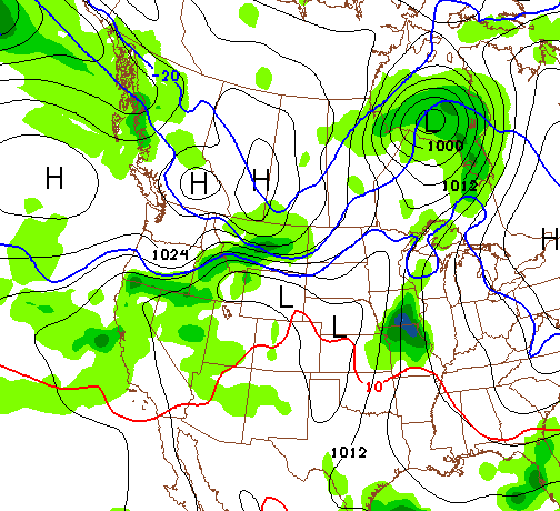
Snow falling across Star Valley this Monday evening will generally decrease and end early Tuesday morning. As of 6 pm Monday 1-3 inches have fallen with another couple inches likely before ending.
Thereafter snow will not be in the forecast until late in the coming weekend, if then.
Riverton has available a video of what is to be expected the next several days and it can be seen on the following link.
Video Christmas Weather Briefing
Monday, December 23, 2013
Sunday, December 22, 2013
Extraordinary Drought In California
There is not much media attention yet, but the drought in California is of historic proportions. The year 2013 is likely going to be the driest ever recorded in both San Francisco and Los Angeles. This is particularly impressive given the period of record for both locations go back to the middle of the 19th century.
Christopher Burt has blogged on the drought, hopefully raising awareness of the potential dire consequences that are possible if the Winter rains/snows do not materialize(so far they have not).
Here is the link to Christopher's blog
California Drought Blog
Christopher Burt has blogged on the drought, hopefully raising awareness of the potential dire consequences that are possible if the Winter rains/snows do not materialize(so far they have not).
Here is the link to Christopher's blog
California Drought Blog
Thursday, December 19, 2013
December 19 2013 Snow Totals
LOCATION SNOWFALL
PUBLIC INFORMATION STATEMENT
NATIONAL WEATHER SERVICE RIVERTON WY
423 PM MST THU DEC 19 2013

...SNOW TOTALS THROUGH 3 PM THURSDAY...
LINCOLN COUNTY...
 KEMMERER...                        7-8 INCHES.
 5 SSE SMOOT...                       3 INCHES.
 HAMS FORK SNOTEL...                  3 INCHES.
 SPRING CREEK DIVIDE SNOTEL...        3 INCHES.
 SALT RIVER SUMMIT SNOTEL...          3 INCHES.
 WILLOW CREEK SNOTEL...               3 INCHES.
 5 NNE THAYNE...                    1.8 INCHES.
 2 SE THAYNE...                     1.5 INCHES.
 KELLEY RANGER STATION SNOTEL...      1 INCH.
 INDIAN CREEK SNOTEL...               1 INCH.
 COTTONWOOD CREEK SNOTEL...           1 INCH.
 BLIND BULL SUMMIT...                 1 INCH.
BIG HORN COUNTY...
 GREYBULL...                          1 INCH.

FREMONT COUNTY...
 DEER PARK SNOTEL...                  3 INCHES.
 SOUTH PASS SNOTEL...                 3 INCHES.
 HOBBS PARK SNOTEL...                 3 INCHES.
 COLD SPRINGS SNOTEL...               3 INCHES.
 LITTLE WARM SNOTEL...                3 INCHES.
 RIVERTON...                          2 INCHES.
 ST. LAWRENCE ALT SNOTEL...           1 INCH.
 TOWNSEND CREEK SNOTEL...             1 INCH.
 LANDER AIRPORT...                  0.8 INCHES.

HOT SPRINGS COUNTY...
 THERMOPOLIS...                       2 INCHES.


NATRONA COUNTY...
 CASPER MOUNTAIN...                9-12 INCHES.
 RENO HILL SNOTEL...                  5 INCHES.
 CASPER AIRPORT...                  4.6 INCHES.
 EVANSVILLE...                      4.5 INCHES.
 4 SW CASPER...                       4 INCHES.
 CASPER...                            4 INCHES.
 EVANSVILLE...                        3 INCHES.

PARK COUNTY...
 POWELL...                            5 INCHES.

SUBLETTE COUNTY...
 LARSEN CREEK SNOTEL...               5 INCHES.
 BIG SANDY OPENING SNOTEL...          4 INCHES.
 POCKET CREEK SNOTEL...               4 INCHES.
 SNIDER BASIN...                      4 INCHES.
 GUNSITE PASS SNOTEL...               3 INCHES.
 ELKHART PARK G.S. SNOTEL...          3 INCHES.
 MARBLETON...                         2 INCHES.
 TRIPLE PEAK SNOTEL...                1 INCH.
 EAST RIM DIVIDE SNOTEL...            1 INCH.
 KENDALL RANGER STATION SNOTEL...     1 INCH.
 NEW FORK LAKE SNOTEL...              1 INCH.

SWEETWATER COUNTY...
 4 NW ROCK SPRINGS...                 1 INCH.

TETON COUNTY...
 3 SW JACKSON...                    0.5 INCHES.
 ALTA...                            0.5 INCHES.

WASHAKIE COUNTY...
 WORLAND...                           3 INCHES.
White Christmas Guarantee
Thursdays snow coupled with additional snow by Saturday will assure Star Valley of a White Christmas again this year. Following is the Video Briefing from Riverton Forecast office through Christmas.
Weekly Video Weather Briefing through Christmas Day.
Weekly Video Weather Briefing through Christmas Day.
Wednesday, December 18, 2013
Drought Update
Snow cover currently across Star Valley ranges from between 2 and 4 inches along the river in the lower valley to over a foot near Smoot in the Upper Valley. These amounts are below a normal snow depth for the middle of December, as the typical amounts would be around 6 inches in the Afton area and about 11 inches near Bedford.
However this is somewhat misleading as the higher elevations of the the Salt Range which provides much of the runoff in the Spring for the Valley have been generally above normal so far this Fall.
Examining the two SNOTEL sites that are in the Salt Range this can be seen.
Both sites have been running above the 30 year normals up to December 18 2013 both in total precipitation and the snow water equivalent of the observed snow pack for the current water year.
Much of Wyoming has been removed from any drought concerns due to the beneficial precipitation that has occurred since last summer.

Following are maps for both this and last year in December that depict the improvement that has occurred in the drought conditions, not only in Wyoming but many others areas of the country.
Only California and Nevada have worsened in the past year.
Looking ahead as to what is forecast for this winter the Northern Rockies are the only area of the country that there is some degree of confidence that greater than normal precipitation will occur.
However the skill levels for a 3 month forecast are still limited.
However this is somewhat misleading as the higher elevations of the the Salt Range which provides much of the runoff in the Spring for the Valley have been generally above normal so far this Fall.
Examining the two SNOTEL sites that are in the Salt Range this can be seen.
 | |
| Willow Creek Snotel |
 | ||
| Cottonwood Creek Snotel |
Much of Wyoming has been removed from any drought concerns due to the beneficial precipitation that has occurred since last summer.

Following are maps for both this and last year in December that depict the improvement that has occurred in the drought conditions, not only in Wyoming but many others areas of the country.
 | ||
| Drought conditions in December of 2012 and 2013. |
Looking ahead as to what is forecast for this winter the Northern Rockies are the only area of the country that there is some degree of confidence that greater than normal precipitation will occur.
 |
| Add caption |
Thursday, December 12, 2013
Weekly Weather Briefing-Warmer Ahead
Following is the link tthe Weekly Weather Briefing issued by the Riverton Forecast Office. Highlight is for temperatures to rise to near or above normal over the coming weekend.
Video Weather Briefing
Video Weather Briefing
Infrared Satellite Option Added to Weather Camera Link
A new feature is now available on the Weather Camera link. The info button will not only provide an option to display the current radar but now a satellite option is available. It will display the current infrared satellite image which can then be overlayed on the radar image. Also there is a room/zoom option enabling the user to examine the entire country.
Following is the description of the Weather Camera link posted in 2012.
The initial post on this blog was a description of the Weather Camera link on the site. This was posted on 10/11/11. John has since improved the site archiving capability and thus a re-posting of the original description with the added info about the improvements follows. The additional discussion is underlined at the end.
The Weather Camera is a link to the site www.halescamvideo.com that was developed by John Hales as a Christmas Gift to me(his father) in 2008. While John provides any technical needs, I am the site manager and maintain quality control of the Cams on the site.
At any given time there could be as many as 130 web cams displayed. The criteria used to determine the display of a camera are:
1. Quality of the image.(StarDot Cameras much preferred).
2. Frequency of updates. (ideally every minute)
3. Proximity to Star Valley WY
4. View of the sky.
5. Reliability
Current Features
Left click on the image will provide a larger current image
The cursor at the top of each cam will open up the control menu for that particular cam.
Left click on the minutes option(30 60 120 180 300) will build a loop of that length in time.
Left click on the info (i) button and it will bring up a google map centered on the webcam location. Additionally it will display the latest weather observation and identifying the location of the observation.
There is also a radar option which when turned on will display the current composite reflectivity product from the NWS
Clicking on the + will open up a looping option. At least 3 days are available in the archive for all cams. Selecting the date/time and looping length in minutes will rebuild a loop.
There are two options when building a loop. The Load Loop option will rebuild a requested time period and display it. A much more powerful option is the Create Video. This will build the requested time period and then display the Download mp4 Video which will then produce a url that can be copied/sent or saved as a video file.
As an example using this command a video was made of the Star Valley Ranch snow gauge on March 2 2012 when the snow depth was at its deepest point during the past winter. This video was created on November 3 2012 as the number of archived days for this particular cam extended back that far.
http://www.camviewing.com/clips/SVH1_2012-11-03-2256MST_300.mp4
While all cams have at least the most recent 3 days archived, additional days can be added to a particular cam upon request.
Monday, December 9, 2013
Monday Morning Minimums
The protective clouds that prevented Star Valley from dipping to the cold levels experienced in other portions of Wyoming the last few nights, dissipated Sunday evening. As a result the coldest readings thus far this Winter Season(not officially Winter yet!) occurred across the Valley this Monday morning. Following are the observed lows as of 8AM Monday December 9, 2013
Thayne ES -23
Double L Ranch -22(could be colder as last reading was 4am)
Smoot -20
2 miles northeast Etna -19
Cake Bread Ranch -18
Etna ES -17
Alpine -15
Star Valley Ranch -14
Afton -13
Other nearby minimums of interest
Bondurant -34
Big Piney -23
Jackson Airport -20
Idaho Falls Airport -19
Pocatello Airport -13
The most notable cold morning was at St George Utah where the minimum dipped to zero after receiving 6 inches of snow over the weekend! Looking back through the record books, the last time St. George hit zero or below in the month of December was 1909 and for any month 1937.
 |
| St. George UT December 8,2013 |
Saturday, December 7, 2013
Saturday Morning Cold
It was another bitter cold morning in much of Wyoming this Saturday morning. Again Star Valley escaped the very cold as clouds provided an insulating blanket

LOCATION                       TEMP      TIME/DATE

...WYOMING...
...LINCOLN...
16 ENE TURNERVILLE (9000 FT)   -20       0300 AM 12/07
13 E COKEVILLE (7460 FT)       -18       0800 AM 12/07
6 WNW GRANGER (6359 FT)        -18       0800 AM 12/07
13 W KEMMERER (6718 FT)        -16       0120 AM 12/07
4 S COKEVILLE (6185 FT)        -13       0400 AM 12/07
BOX Y RANCH (6650 FT)          -13       0500 AM 12/07
MT COFFIN (10870 FT)           -13       0800 PM 12/06
DEADMAN MTN (10350 FT)         -12       0800 PM 12/06
KEMMERER (6980 FT)             -11       0145 AM 12/07
4 W KEMMERER (6989 FT)         -10       1200 AM 12/07
4 E OPAL (6589 FT)             -9        0600 AM 12/07
KEMMERER AIRPORT (7285 FT)     -8        0130 AM 12/07
BEDFORD - COOP (6425 FT)       -7        0700 AM 12/07
5 SSE LA BARGE (6530 FT)       -7        0600 AM 12/07
COKEVILLE (6160 FT)            -6        0400 AM 12/07
9 N KEMMERER (7129 FT)         -6        1141 PM 12/06
3 E SAGE JUNCTION (6378 FT)    -5        0300 AM 12/07
15 NE COKEVILLE (8470 FT)      -5        0300 AM 12/07
4 E SAGE JUNCTION (6387 FT)    -3        0121 AM 12/07
AFTON - COOP (6245 FT)         -2        0800 AM 12/07
6 S ALPINE (5676 FT)           0         0515 AM 12/07
AFTON AIRPORT - AWOS (6220 FT) 0         0415 AM 12/07
1 NW AFTON (6211 FT)           0         0515 AM 12/07
4 ESE DIAMONDVILLE (6789 FT)   0         0500 AM 12/07
3 NNE ETNA (5997 FT)           0         0401 AM 12/07
THAYNE (5928 FT)               1         0610 AM 12/07
ETNA (5823 FT)                 1         0532 AM 12/07
AFTON (6267 FT)                2         0240 AM 12/07
1 ESE FREEDOM (5797 FT)        3         0517 AM 12/07
4 NE THAYNE (6217 FT)          3         0556 AM 12/07
3 NW ETNA (5692 FT)            5         0855 AM 12/07
...BIG HORN...
SHELL (4285 FT)                -25       0545 AM 12/07
GREYBULL (3860 FT)             -23       1018 AM 12/07
13 NE TEN SLEEP (8038 FT)      -22       0535 AM 12/07
5 NW GRANITE PASS (9350 FT)    -21       0800 PM 12/06
GREYBULL AIRPORT (3935 FT)     -21       1053 AM 12/07
17 E SHELL (9580 FT)           -21       0900 PM 12/06
BASIN (3897 FT)                -18       0311 AM 12/07
BALD MTN. (9380 FT)            -18       0800 PM 12/06
BASIN (3884 FT)                -17       0308 AM 12/07
30 E GREYBULL (8898 FT)        -17       0858 PM 12/06
5 ENE HYATTVILLE (5670 FT)     -15       0652 AM 12/07
LOVELL (3830 FT)               -12       0558 AM 12/07

...FREMONT...
DUBOIS (6980 FT)               -24       0440 AM 12/07
22 WNW DUBOIS (9340 FT)        -22       0130 AM 12/07
3 E FORT WASHAKIE (5528 FT)    -21       0620 AM 12/07
6 NW DUBOIS (7189 FT)          -19       0615 AM 12/07
5 WSW DUBOIS (9370 FT)         -19       0600 AM 12/07
LANDER (5320 FT)               -19       0655 AM 12/07
JEFFREY CITY (6320 FT)         -19       0700 AM 12/07
17 NE DUBOIS (8400 FT)         -19       1200 AM 12/07
13 W CROWHEART (9630 FT)       -19       1100 PM 12/06
RIVERTON FORECAST OFFICE       -19       1200 AM 12/07
7 NW LANDER (5797 FT)          -19       0640 AM 12/07
BURRIS (6120 FT)               -18       0630 AM 12/07
2 S RIVERTON (4901 FT)         -18       0200 AM 12/07
HUDSON (5090 FT)               -18       0640 AM 12/07
12 SW LANDER (8700 FT)         -18       0600 AM 12/07
N WIND RIVER MTS (8833 FT)     -17       0610 AM 12/07
4 SW LANDER (5807 FT)          -17       0626 AM 12/07
RIVERTON (4950 FT)             -17       0700 AM 12/07
11 NE RIVERTON (5016 FT)       -17       0558 AM 12/07
10 W DUBOIS (8432 FT)          -17       0535 AM 12/07
1 WNW DUBOIS (7014 FT)         -17       0231 AM 12/07
JEFFREY CITY (6374 FT)         -17       0730 AM 12/07
6 S TOGWOTEE PASS (10430 FT)   -16       0200 AM 12/07
10 N DUBOIS (8085 FT)          -16       1057 PM 12/06
LANDER AIRPORT (5586 FT)       -16       1053 AM 12/07
13 W FORT WASHAKIE (8620 FT)   -16       0600 AM 12/07
9 SW LANDER (7085 FT)          -15       0815 AM 12/07
RIVERTON AIRPORT (5525 FT)     -15       0453 AM 12/07
CROWHEART (6099 FT)            -15       0251 AM 12/07
BOYSEN DAM (4760 FT)           -14       0600 AM 12/07
7 WNW RIVERTON (5407 FT)       -14       0420 AM 12/07
10 SE CROWHEART (5654 FT)      -13       0215 AM 12/07
RED CANYON (6768 FT)           -13       0755 AM 12/07
1 SW LANDER (5480 FT)          -13       0730 AM 12/07
11 W CROWHEART (6520 FT)       -12       0500 AM 12/07
8 W SOUTH PASS CITY (8120 FT)  -12       1050 PM 12/06
2 W SOUTH PASS CITY (8185 FT)  -12       0751 PM 12/06
SOUTH PASS (9040 FT)           -11       0900 PM 12/06
BOYSEN RESERVOIR (4710 FT)     -10       0600 AM 12/07
BEAVER RIM (6784 FT)           -10       0911 PM 12/06
18 W LANDER (10100 FT)         -10       0800 AM 12/07
10 W FORT WASHAKIE (9235 FT)   -9        0801 PM 12/06
SOUTH PASS CITY (8540 FT)      -9        1015 PM 12/06
1 NNE ATLANTIC CITY (8292 FT)  -8        0600 AM 12/07
10 NW SOUTH PASS CITY          -8        0800 PM 12/06
7 SW MUDDY GAP (7380 FT)       -6        0750 PM 12/06

...HOT SPRINGS...
10 S MEETEETSE (7127 FT)       -20       0242 AM 12/07
THERMOPOLIS 9 NE (4280 FT)     -19       0600 AM 12/07
THERMOPOLIS (4330 FT)          -18       0705 AM 12/07
39 W THERMOPOLIS (8975 FT)     -16       1100 PM 12/06
1 WSW THERMOPOLIS (4426 FT)    -16       0500 AM 12/07
KIRBY (4328 FT)                -10       0606 AM 12/07

...JOHNSON...
1 E BUFFALO (4727 FT)          -25       0604 AM 12/07
5 ESE STORY (4673 FT)          -24       0701 AM 12/07
8 ENE BUFFALO (4370 FT)        -24       0640 AM 12/07
18 WNW BUFFALO (8580 FT)       -23       0530 AM 12/07
BUFFALO (4635 FT)              -23       0520 AM 12/07
20 SW ECHETA (4068 FT)         -23       0530 AM 12/07
15 W BUFFALO (8720 FT)         -22       0900 PM 12/06
2 NW MAYOWORTH (5404 FT)       -22       0629 AM 12/07
BUFFALO AIRPORT (4970 FT)      -22       1053 AM 12/07
25 ESE BUFFALO (4657 FT)       -20       0720 AM 12/07
8 ENE MAYOWORTH (5287 FT)      -20       0641 AM 12/07
POWDER RIVER PASS (9480 FT)    -18       0800 PM 12/06
KAYCEE (4681 FT)               -18       0603 AM 12/07
7 SW BARNUM (6440 FT)          -16       1146 PM 12/06
15 WSW BUFFALO (8360 FT)       -16       0800 PM 12/06
18 NW BUFFALO (8604 FT)        -15       0847 PM 12/06
14 WSW STORY (8870 FT)         -15       0800 PM 12/06
14 WNW MAYOWORTH (8200 FT)     -12       1200 AM 12/07
7 WSW BUFFALO (5745 FT)        -12       0600 AM 12/07


...NATRONA...
POWDER RIVER (5695 FT)         -27       0800 AM 12/07
21 W ALCOVA (5920 FT)          -26       0300 AM 12/07
CASPER AIRPORT (5320 FT)       -21       1053 PM 12/06
2 SE HILAND (6134 FT)          -20       0216 AM 12/07
16 S HILAND (6380 FT)          -19       0310 AM 12/07
MIDWEST (4860 FT)              -19       0920 AM 12/07
14 N BAR NUNN (5677 FT)        -17       1106 PM 12/06
MIDWEST (4865 FT)              -17       0759 AM 12/07
7 W ALCOVA (6342 FT)           -16       0540 AM 12/07
MILLS (5150 FT)                -15       0945 PM 12/06
PATHFINDER RESERVOIR (5858 FT) -14       0500 AM 12/07
CASPER - N PLATTE RIVER        -14       0915 PM 12/06
1 SSE MILLS (5222 FT)          -14       0800 AM 12/07
28 N WALTMAN (8550 FT)         -10       0900 PM 12/06
8 S CASPER (7740 FT)           -6        0752 PM 12/06

...PARK...
3 NE CLARK (4090 FT)           -28       0800 AM 12/07
TOWER FALLS (6266 FT)          -28       0800 AM 12/07
19 SSW WAPITI (6200 FT)        -25       0400 AM 12/07
BUFFALO BILL RESERVOIR         -25       0500 AM 12/07
PAHASKA (6696 FT)              -23       0700 AM 12/07
1 W CLARK (4270 FT)            -23       0612 AM 12/07
5 WNW CLARK (4659 FT)          -22       0602 AM 12/07
CODY AIRPORT (5100 FT)         -22       0335 AM 12/07
8 N MEETEETSE (5926 FT)        -21       0541 AM 12/07
17 SW MEETEETSE (7950 FT)      -20       0800 PM 12/06
MEETEETSE (5797 FT)            -20       0603 AM 12/07
WAPITI (5400 FT)               -19       0400 AM 12/07
CHIEF JOSEPH HWY MILE 9        -19       0612 AM 12/07
N. ABSAROKA MTS (7650 FT)      -18       1100 PM 12/06
2 W CODY (4921 FT)             -18       0747 PM 12/06
2 N FRANNIE (4275 FT)          -18       1231 AM 12/07
MAMMOTH (6300 FT)              -17       0515 AM 12/07
BEARTOOTH LAKE (9275 FT)       -17       0500 AM 12/07
3 E PAHASKA (7500 FT)          -16       0357 AM 12/07
CHIEF JOSEPH HWY (8136 FT)     -16       0725 PM 12/06
1 WNW POWELL (4386 FT)         -16       0600 AM 12/07
1 W POWELL (4462 FT)           -16       0617 AM 12/07
4 W PAHASKA (7120 FT)          -15       0200 AM 12/07
TOWER FALLS (6266 FT)          -14       0130 AM 12/07
PAHASKA (6800 FT)              -14       0400 AM 12/07
1 SW CANYON (7900 FT)          -14       0249 AM 12/07
HOYT PEAK (9800 FT)            -13       0730 PM 12/06
KIRWIN SNOTEL (9550 FT)        -13       0800 PM 12/06
10 WNW CODY (8401 FT)          -12       0740 PM 12/06
PARKER PEAK (E. YNP) (9400 FT) -11       0200 AM 12/07
1 SW CANYON (8090 FT)          -11       0200 AM 12/07
14 WSW MAMMOTH (7900 FT)       -10       0249 AM 12/07
12 SE PAHASKA (9780 FT)        -10       0800 PM 12/06
18 SW CODY (8760 FT)           -9        0800 PM 12/06
14 S SYLVAN PASS (8650 FT)     -8        1008 PM 12/06
14 NE PAHASKA (9200 FT)        -7        0500 AM 12/07

...SUBLETTE...
DANIEL FISH HATCHERY - COOP    -28       0800 AM 12/07
21 W BIG PINEY (8200 FT)       -27       0309 AM 12/07
6 WNW CORA (7462 FT)           -25       0504 AM 12/07
8 SE BONDURANT (7797 FT)       -25       0541 AM 12/07
BOULDER REARING STATION - COOP -22       0800 AM 12/07
10 NNW DANIEL (7470 FT)        -19       0500 AM 12/07
PINEDALE AIRPORT (7085 FT)     -18       0655 AM 12/07
9 E BIG PINEY (6803 FT)        -17       0800 AM 12/07
PINEDALE (7195 FT)             -17       0700 AM 12/07
5 S DANIEL (7133 FT)           -16       0600 AM 12/07
BIG PINEY AIRPORT (6974 FT)    -15       1053 AM 12/07
BONDURANT (6650 FT)            -15       1030 PM 12/06
MARBLETON (6896 FT)            -14       0112 AM 12/07
PINEDALE (7310 FT)             -13       0630 AM 12/07
6 W BOULDER (7113 FT)          -13       0700 AM 12/07
2 NW BONDURANT (6726 FT)       -11       1051 PM 12/06
18 SSW BIG SANDY (6614 FT)     -9        0800 AM 12/07
6 NE PINEDALE (7839 FT)        -8        1100 PM 12/06
BOULDER LAKE (7350 FT)         -7        0700 AM 12/07
14 N FARSON (6780 FT)          11        1200 PM 12/07

...SWEETWATER...
5 E ROCK SPRINGS (6369 FT)     -20       0240 AM 12/07
8 E ROCK SPRINGS (6339 FT)     -19       0300 AM 12/07
3 NW ROCK SPRINGS (6458 FT)    -19       0254 AM 12/07
7 WNW GREEN RIVER (6387 FT)    -18       0812 AM 12/07
12 W GREEN RIVER (6130 FT)     -18       0200 AM 12/07
FARSON (6594 FT)               -17       0355 AM 12/07
7 WSW ROCK SPRINGS (6238 FT)   -17       0310 AM 12/07
5 SSE POINT OF ROCKS (6568 FT) -17       0400 AM 12/07
3 ENE GRANGER (6254 FT)        -17       0800 AM 12/07
GREEN RIVER (6091 FT)          -14       0744 AM 12/07
I 80 - MILE MARKER 131         -14       0840 PM 12/06
GREEN RIVER (6060 FT)          -14       0800 AM 12/07
22 NNE GRANGER (6322 FT)       -14       0443 AM 12/07
I 80 - MILE MARKER 124         -13       0851 PM 12/06
9 WNW GREEN RIVER (6290 FT)    -13       0600 AM 12/07
14 NE GRANGER (6454 FT)        -13       0700 AM 12/07
GREEN RIVER (6133 FT)          -13       0700 AM 12/07
6 WSW ROCK SPRINGS (6212 FT)   -12       0300 AM 12/07
FLAMING GORGE - BUCKBOARD MARI -12       0745 AM 12/07
1 NNE GREEN RIVER (6315 FT)    -12       0807 AM 12/07
15 ESE POINT OF ROCKS          -10       0145 AM 12/07
44 SE ROCK SPRINGS (7108 FT)   -10       1200 AM 12/07
3 NE MANILA UT (6060 FT)       -10       0200 AM 12/07
1 E RED DESERT (6722 FT)       -9        0500 AM 12/07
I 80 - MILE MARKER 184         -8        0741 PM 12/06
I 80 - MILE MARKER 142         -8        0910 PM 12/06
ROCK SPRINGS AIRPORT (6760 FT) -8        0454 AM 12/07
I 80 - MILE MARKER 157         -7        0755 PM 12/06
10 E WAMSUTTER (7062 FT)       -7        0800 PM 12/06
16 W RED DESERT (6805 FT)      -7        0800 PM 12/06
23 W WAMSUTTER (6804 FT)       -7        0800 PM 12/06
13 E WAMSUTTER (7052 FT)       -6        0800 PM 12/06
15 SE ROCK SPRINGS (7550 FT)   -6        0844 PM 12/06
1 S FONTENELLE RESERVOIR       -4        1200 AM 12/07

...TETON...
OLD FAITHFUL (7360 FT)         -28       0800 AM 12/07
1 W GRANT VILLAGE (7874 FT)    -25       0145 AM 12/07
YELLOWSTONE LAKE (7835 FT)     -23       1156 PM 12/06
MORAN (6800 FT)                -22       0800 AM 12/07
MOOSE - COOP (6445 FT)         -19       0830 AM 12/07
OLD FAITHFUL (7320 FT)         -18       0200 AM 12/07
TOGWOTEE MTN LODGE (9184 FT)   -16       1015 PM 12/06
15 SE MORAN JCT (10380 FT)     -15       1015 PM 12/06
23 E MORAN JUNCTION (9576 FT)  -15       1050 PM 12/06
3 WNW TETON VILLAGE (9608 FT)  -15       0800 PM 12/06
OLD FAITHFUL (7350 FT)         -14       0300 AM 12/07
SUMMIT - JACKSON RESORT        -14       0730 PM 12/06
FIREHOLE CANYON (YNP)          -14       0115 AM 12/07
JACKSON - COOP (6210 FT)       -13       0900 AM 12/07
5 ENE ALTA (8800 FT)           -13       0900 PM 12/06
4 W SOUTH ENTRANCE YNP         -12       0815 PM 12/06
ALTA - COOP (6435 FT)          -11       0900 PM 12/06
SOUTH ENTRANCE YNP (6900 FT)   -10       0230 AM 12/07
RAYMER - JACKSON RESORT        -10       0730 PM 12/06
7 E MORAN JCT (7251 FT)        -10       1252 AM 12/07
5 ENE ALTA - FREDS MTN         -9        1000 PM 12/06
1 NNE LAKE (7875 FT)           -8        1215 AM 12/07
MORAN JUNCTION (6749 FT)       -8        0104 AM 12/07
5 S OF SOUTH ENTRANCE YNP      -8        0215 AM 12/07
TETON PASS (8463 FT)           -7        0725 PM 12/06
SNAKE RIVER AT JACKSON LAKE DA -6        0215 AM 12/07
4 N MOOSE (6730 FT)            -6        0758 PM 12/06
2 WNW TETON VILLAGE (8179 FT)  -5        1030 PM 12/06
EXTREME SW YELLOWSTONE         -5        0849 PM 12/06
3 SW MOOSE (6440 FT)           -4        0738 PM 12/06
1 S JACKSON (7810 FT)          -4        0600 AM 12/07
JACKSON HOLE AIRPORT (6445 FT) -4        1055 PM 12/06
JACKSON (6240 FT)              -1        0745 PM 12/06
JACKSON (6247 FT)              0         0737 PM 12/06
15 NNE GRAND TARGHEE (6830 FT) 0         1203 AM 12/07
2 WNW TETON VILLAGE (6339 FT)  0         0530 AM 12/07
2 ENE WILSON (6184 FT)         1         0558 AM 12/07
ALTA (6430 FT)                 2         1000 PM 12/06
4 SW JACKSON (6073 FT)         2         0623 AM 12/07
2 SW TETON VILLAGE (6221 FT)   3         0843 PM 12/06
3 SSW JACKSON (6158 FT)        3         0556 AM 12/07
HOBACK JUNCTION (5928 FT)      5         1103 PM 12/06

...WASHAKIE...
TENSLEEP (4680 FT)             -30       0700 AM 12/07
TEN SLEEP (4470 FT)            -18       0748 AM 12/07
WORLAND AIRPORT (4245 FT)      -17       1053 AM 12/07
S. BIGHORN MTS (6554 FT)       -17       0940 PM 12/06
1 NE WORLAND (4037 FT)         -16       0629 AM 12/07
WORLAND (4052 FT)              -16       0554 AM 12/07
WORLAND (4042 FT)              -15       0704 AM 12/07
30 SE TEN SLEEP (7760 FT)      -14       0900 PM 12/06
12 ENE TEN SLEEP (8202 FT)     -14       1114 PM 12/06
WORLAND (4060 FT)              -12       0700 AM 12/07

To the north it was even colder in Montana and adjacent portions of Canada as seen on the following graphic of this mornings minimums
 |
| Saturday minimums Dec. 7 2013 |
Friday, December 6, 2013

Thursday, December 5, 2013
Weekly Video Briefing-Cold to Continue
Riverton Forecast Office has issued their weekly Weather Briefing highlighting the continued COLD
Weekly Weather Briefing
Weekly Weather Briefing
COLD!!!!!!!!
Star Valley escaped the extreme cold that was observed overnight in many areas of the Mountain West, thanks to a thin blanket of low clouds and moisture. While much of the valley was below zero, the coldest observed so far near Smoot, with -13, it was considerably colder in other areas.
Following is a map of minimum temperatures around the Star Valley area as of 7 am Thursday.
Note just across the mountains at the Box Y Ranch it was -23F.
Around the region there so far have been many readings between -25 and -35F, with the coldest being a
-42F at Peter Sinks UT, a historically frigid high elevation valley near Logan Pass.
Peter Sinks -42F occurred during the evening after there was sufficient mixing and/or clouds to keep it from falling further!

Following is a map of minimum temperatures around the Star Valley area as of 7 am Thursday.
 |
| Minimum temperatures Thursday December 5 ,2013 |
Around the region there so far have been many readings between -25 and -35F, with the coldest being a
-42F at Peter Sinks UT, a historically frigid high elevation valley near Logan Pass.
 |
| Minimum temperatures of -25 F or lower on December 5, 2013 |

Tuesday, December 3, 2013
Storm Snow Totals for Dec 1-3
PRELIMINARY SNOWFALL AMOUNTS FROM OUR LATEST STORM BETWEEN SUNDAY
AND 3 PM TUESDAY AFTERNOON.

LOCATION                             SNOWFALL

BIG HORN COUNTY...
 BONE SPRINGS DIVIDE SNOTEL...        7 INCHES.
 BALD MOUNTAIN SNOTEL...              6 INCHES.
 SHELL CREEK SNOTEL...                4 INCHES.
 2 SSW LOVELL...                      2 INCHES.
 SHELL...                           1.5 INCHES.

FREMONT COUNTY...
 BROOKS LAKE LODGE...                13 INCHES.
 CASTLE CREEK SNOTEL...              13 INCHES.
 SOUTH PASS SNOTEL...                11 INCHES.
 LITTLE WARM SNOTEL...               11 INCHES.
 DEER PARK SNOTEL...                 10 INCHES.
 COLD SPRINGS SNOTEL...               9 INCHES.
 HOBBS PARK SNOTEL...                 7 INCHES.
 9.5 SW LANDER...                     6 INCHES.
 ATLANTIC CITY...                   4.4 INCHES.
 HUDSON...                            4 INCHES.
 DUBOIS...                            3 INCHES.
 ST. LAWRENCE ALT SNOTEL...           3 INCHES.
 2 E SWEETWATER STATION...            3 INCHES.
 LANDER AIRPORT...                  2.2 INCHES.
 LANDER...                            2 INCHES.
 RIVERTON AIRPORT...                  2 INCHES.
 1 SW LANDER...                     1.8 INCHES.
 1 W LANDER...                      1.1 INCHES.
 BOYSEN DAM...                        1 INCH.
 RIVERTON...                          1 INCH.
 LANDER...                            1 INCH.
 TOWNSEND CREEK SNOTEL...             1 INCH.
 6 SW LANDER...                     0.8 INCHES.

HOT SPRINGS COUNTY...
 OWL CREEK SNOTEL...                  5 INCHES.
 1 SW THERMOPOLIS...                  4 INCHES.
 9 NE THERMOPOLIS...                1.8 INCHES.

JOHNSON COUNTY...
 LITTLE GOOSE SNOTEL...               7 INCHES.
 CLOUD PEAK RESERVOIR SNOTEL...       7 INCHES.
 4 SSW BUFFALO...                     6 INCHES.
 SOLDIER PARK SNOTEL...               6 INCHES.
 20 S BUFFALO...                    5.5 INCHES.
 HANSEN SAWMILL SNOTEL...             5 INCHES.
 6 WNW BUFFALO...                   4.5 INCHES.
 BUFFALO...                         3.5 INCHES.
 KAYCEE...                            2 INCHES.

LINCOLN COUNTY...
 BLIND BULL SUMMIT SNOTEL...         30 INCHES.
 COMMISSARY RIDGE...                 23 INCHES.
 WILLOW CREEK SNOTEL...              22 INCHES.
 BLIND BULL SUMMIT...                22 INCHES.
 COTTONWOOD CREEK SNOTEL...          21 INCHES.
 SPRING CREEK DIVIDE SNOTEL...       21 INCHES.
 INDIAN CREEK SNOTEL...              20 INCHES.
 BOX Y RANCH...                      18 INCHES.
 SALT RIVER SUMMIT SNOTEL...         10 INCHES.
 KELLEY RANGER STATION SNOTEL...      9 INCHES.
 HAMS FORK SNOTEL...                  6 INCHES.
 KEMMERER...                        5.5 INCHES.
 5 SSE SMOOT...                       5 INCHES.
 2 SE THAYNE...                     4.2 INCHES.
 AFTON...                           0.5 INCHES.

NATRONA COUNTY...
 SOUTH CASPER...                    2-4 INCHES.
 MARTIN'S COVE...                     3 INCHES.
 MIDWEST...                           2 INCHES.
 RENO HILL SNOTEL...                  2 INCHES.
 CASPER MOUNTAIN SNOTEL...            2 INCHES.
 5 SSW CASPER...                      2 INCHES.
 CASPER MOUNTAIN...                 2-3 INCHES.
 CASPER AIRPORT...                  1.4 INCHES.
 CASPER...                          1.1 INCHES.
 POWDER RIVER SCHOOL...               1 INCH.
 1 WSW CASPER...                      1 INCH.

PARK COUNTY...
 BEARTOOTH LAKE SNOTEL...            19 INCHES.
 EVENING STAR SNOTEL...              19 INCHES.
 BLACKWATER SNOTEL...                18 INCHES.
 WOLVERINE SNOTEL...                 12 INCHES.
 PAHASKA...                          11 INCHES.
 TIMBER CREEK SNOTEL...               7 INCHES.
 KIRWIN SNOTEL...                     6 INCHES.
 3 NE SUNSHINE...                   5.7 INCHES.
 MEETEETSE...                       4 TO 5.5 INCHES.
 CODY...                              4 INCHES.
 4 SW POWELL...                     3.2 INCHES.
 MARQUETTE SNOTEL...                  3 INCHES.
 2 WSW CODY...                        3 INCHES.
 4 SE CODY...                       2.7 INCHES.
 3 NE CLARK...                      2.5 INCHES.
 CODY...                              2 INCHES.
 3 NE CODY...                         2 INCHES.
 4 ENE POWELL...                      2 INCHES.

SUBLETTE COUNTY...
 KENDALL RANGER STATION SNOTEL...    26 INCHES.
 TRIPLE PEAK SNOTEL...               23 INCHES.
 LOOMIS PARK SNOTEL...               21 INCHES.
 GUNSITE PASS SNOTEL...              19 INCHES.
 ELKHART PARK G.S. SNOTEL...         17 INCHES.
 NEW FORK LAKE SNOTEL...             17 INCHES.
 EAST RIM DIVIDE SNOTEL...           14 INCHES.
 SNIDER BASIN SNOTEL...              14 INCHES.
 MERNA...                            12 INCHES.
 10 N CORA...                        12 INCHES.
 BONDURANT...                       9.2 INCHES.
 14 NW PINEDALE...                  7.8 INCHES.
 LARSEN CREEK SNOTEL...               7 INCHES.
 BIG SANDY OPENING SNOTEL...          7 INCHES.
 POCKET CREEK SNOTEL...               4 INCHES.
 PINEDALE...                        2.3 INCHES.
 DANIEL FISH HATCHERY...            1.2 INCHES.
 BOULDER...                           1 INCH.

SWEETWATER COUNTY...
 GREEN RIVER...                     4-7 INCHES.
 BURNTFORK...                         7 INCHES.
 BUCKBOARD MARINA...                  5 INCHES.
 WAMSUTTER...                         5 INCHES.
 ROCK SPRINGS...                    3-4 INCHES.
 BAIROIL...                           2 INCHES.
 GRANGER...                           2 INCHES.
 GREEN RIVER...                       2 INCHES.
 FARSON...                          1.5 INCHES.
 33 N WAMSUTTER...                    1 INCH.

TETON COUNTY...
 BASE CAMP SNOTEL...                 22 INCHES.
 GRAND TARGHEE SNOTEL...             21 INCHES.
 JACKSON HOLE-RAYMER...              21 INCHES.
 JACKSON HOLE-RENDEZVOUS BOWL...     20 INCHES.
 GRANITE CREEK SNOTEL...             18 INCHES.
 TOGWOTEE PASS SNOTEL...             18 INCHES.
 JACKSON HOLE-MID...                 18 INCHES.
 GRAND TARGHEE-CHIEF JOSEPH...       18 INCHES.
 GRASSY LAKE SNOTEL...               17 INCHES.
 PHILLIPS BENCH SNOTEL...            17 INCHES.
 TOGWOTEE MOUNTAIN LODGE...          16 INCHES.
 GROS VENTRE SUMMIT SNOTEL...        12 INCHES.
 SNAKE RIVER STN SNOTEL...           12 INCHES.
 5 WNW MORAN...                    11.6 INCHES.
 SNOW KING SKI AREA...                9 INCHES.
 ALTA...                            6.5 INCHES.
 MOOSE...                           5.9 INCHES.
 1 NNW ALTA...                        5 INCHES.
 12 NE JACKSON...                     4 INCHES.
 MOOSE...                             4 INCHES.
 JACKSON HOLE-BASE...                 3 INCHES.
 2 NE TETON VILLAGE...              1.5 INCHES.
 JACKSON...                         1.1 INCHES.
 12 NE JACKSON...                     1 INCH.
 4 SSW JACKSON...                   0.7 INCHES.
 5 NW JACKSON...                    0.3 INCHES.

WASHAKIE COUNTY...
 MIDDLE POWDER SNOTEL...              4 INCHES.
 POWDER RIVER PASS SNOTEL...          3 INCHES.
 8 SW WORLAND...                      1 INCH.
 WINCHESTER...                      0.3 INCHES.
 TEN SLEEP...                       0.2 INCHES.

YELLOWSTONE NATIONAL PARK...
 TWO OCEAN PLATEAU SNOTEL...         26 INCHES.
 LEWIS LAKE DIVIDE SNOTEL...         22 INCHES.
 PARKER PEAK SNOTEL...               14 INCHES.
 THUMB DIVIDE SNOTEL...              13 INCHES.
 SYLVAN ROAD SNOTEL...               11 INCHES.
 CANYON SNOTEL...                    10 INCHES.
 SYLVAN LAKE SNOTEL...               10 INCHES.
 OLD FAITHFUL RANGER STATION...       5 INCHES.
 TOWER FALLS RANGER STATION...      4.6 INCHES.
Sunday, December 1, 2013
Winter Storm Update
Star Valley is on the verge of experiencing one of the strongest winter storms in some time. Snow has already started with an inch or two as of noon Sunday. While the snow will continue at times through Sunday night and then pick up on Monday as the intense cold upper trough approaches from the Pacific Northwest. Following is a statement issued from the Riverton Forecast Office.

...HIGH IMPACT WINTER STORM LIKELY TODAY THROUGH MONDAY NIGHT...

.A WINTER STORM WILL WILL MOVE INTO THE WEST TODAY AND BRING HEAVY
SNOW THROUGH MONDAY NIGHT. SNOW WILL BE HEAVY AT TIMES
WITH OVER TWO FEET POSSIBLE IN THE WESTERN MOUNTAINS. STRONG
WINDS WILL CAUSE CONSIDERABLE BLOWING AND DRIFTING SNOW. A SURGE
OF ARCTIC AIR WILL ARRIVE MONDAY NIGHT...DROPPING TEMPERATURES
SIGNIFICANTLY BUT DECREASING WIND SPEEDS. SNOW SHOULD BECOME LIGHT
AFTER THE PASSAGE OF THE FRONT ON TUESDAY.

STAR VALLEY-
INCLUDING THE CITIES OF...AFTON...ALPINE...THAYNE
234 AM MST SUN DEC 1 2013

...WINTER STORM WARNING IN EFFECT UNTIL 5 AM
MST TUESDAY...

THE NATIONAL WEATHER SERVICE IN RIVERTON HAS ISSUED A WINTER
STORM WARNING FOR SNOW AND BLOWING SNOW...WHICH IS IN EFFECT
FROM 11 AM THIS MORNING TO 5 AM MST TUESDAY. THE WINTER STORM
WATCH IS NO LONGER IN EFFECT.

* SUMMARY AND TIMING...LIGHT SNOW WILL BEGIN THIS MORNING AND
  BECOME STEADIER AND HEAVIER THIS AFTERNOON AND EVENING. THE
  SNOWFALL WILL BECOME ESPECIALLY HEAVY MONDAY AFTERNOON AND NIGHT
  AS THE COLD FRONT PUSHES THROUGH. SNOW WILL BECOME LIGHT ON TUESDAY.

* SNOW ACCUMULATIONS...6 TO 12 INCHES IN ACROSS THE SOUTHERN STAR
  VALLEY INCLUDING AFTON WITH UP TO 15 INCHES IN THE NORTH.

* WIND AND VISIBILITY...WEST SOUTHWEST WINDS INCREASING TO 20 TO
  30 MPH WITH HIGHER GUSTS. VISIBILITY WILL BE REDUCED TO UNDER
  ONE QUARTER MILE IN HEAVY SNOW AND BLOWING SNOW.

* IMPACTS...PERIODS OF HEAVY SNOW...BLOWING AND DRIFTING SNOW IN
  ADDITION TO STRONG WINDS WILL MAKE TRAVEL DIFFICULT. THOSE WITH
  OUTDOOR INTERESTS ARE URGED TO PREPARE FOR DIFFICULT TRAVEL...
  WHITEOUT CONDITIONS AND SHARPLY COLDER TEMPERATURES.

PRECAUTIONARY/PREPAREDNESS ACTIONS...

A WINTER STORM WARNING FOR HEAVY SNOW MEANS SEVERE WINTER WEATHER
CONDITIONS ARE EXPECTED OR OCCURRING.  SIGNIFICANT AMOUNTS OF
SNOW ARE FORECAST THAT WILL MAKE TRAVEL DANGEROUS. ONLY TRAVEL IN
AN EMERGENCY. IF YOU MUST TRAVEL...KEEP AN EXTRA FLASHLIGHT...
FOOD...AND WATER IN YOUR VEHICLE IN CASE OF AN EMERGENCY.

THE LATEST ROAD CONDITIONS PROVIDED BY THE WYOMING DEPARTMENT OF
TRANSPORTATION ARE AVAILABLE BY CALLING 5-1-1 OR ON THE INTERNET
AT WYOROAD.INFO.
Much of the snowfall will occur by late Monday, at which time the very cold air will pour southward across much of the area.
Following is a forecast graphic issued for the probability of a foot or more of snow falling by Tuesday evening.

The real story this week will be the COLD that will dominate through at least the weekend. Following are a couple graphics with the forecast lows later this week.
 |
| Minimums Thursday morning December 5 2013 |
 |
| Minimums Monday Morning December 9, 2013
NOTE THAT THE AREA OF WHITE IS 30 BELOW ZERO! This will be the coldest period experienced in Western Wyoming in some time.
The long range forecast has cold air covering much of the western two thirds of the U.S. for the period from December 6-10 2013.
 |
Saturday, November 30, 2013
Be Prepared for A Winter Blast
The major winter blast is still on schedule for this coming week. Snow, likely several inches in the Valley and a foot or more in the higher elevations will precede the turn to bitter cold temperatures by mid week. The storm is located over Alaska this Saturday morning, but will make a sharp right turn and head toward the Northern Rockies and Wyoming.
Here are a series of 500 mb charts showing the big change in pattern taking place over the next few days.
Here are a series of 500 mb charts showing the big change in pattern taking place over the next few days.
 |
| Saturday Morning Nov 30 2013 |
 |
| Monday Morning Dec. 2 2013 |
 |
| Tuesday Evening Dec. 3 2013 |
While the snow could be substantial, particularly in the higher elevations, the real story will be the bitter cold. By mid week, daytime temperatures will likely remain in the single digits, even in the Valley. with overnight lows dropping well below zero. Once the cold air arrives, the snow should diminish and then end and skies could clear. This could potentially lead to low temperatures in Star Valley dipping to minus 20 or even lower later in the week. The pattern is expected to remain favorable for the bitter cold to remain through next weekend.
Following is a link to the lastest advisories being issued by the Riverton Forecast Office.
Thursday, November 28, 2013
Bitter Cold Next Week
Riverton Forecast Office highlights the coming cold outbreak next week in Wyoming.
Riverton Forecast Office Video weather briefing
Riverton Forecast Office Video weather briefing
Tuesday, November 26, 2013
Updated Video for Thanksgiving Weekend
Riverton Forecast Office has prepared an updated Video Briefing for weather expected over the Thanksgiving weekend and the first of next week.
Updated Holiday Weather Video
Updated Holiday Weather Video
Post Thanksgiving Weekend Winter Weather Alert
While the Western States will experience a generally quiet and seasonably mild Thanksgiving Holiday Weekend, big changes will be underway by the end of the weekend.
A major adjustment in the large scale wind pattern is now being forecast by all the computer models as a strong ridge of high pressure builds from the Northeastern Pacific into Alaska. This will in turn lead to a very deep and cold trough into the western states by the first of the week.
This change in pattern can be seen in the forecast models of the 300mb height and winds fields and the change that occurs from mid day Friday to mid day Tuesday December 3rd.
Note not only the relatively high degree of confidence of below temperatures in the northwestern third of the lower 48, but the unseasonably mild conditions over Alaska reflecting the strong high pressure ridge.
The Intermountain States including the Star Valley region has a high degree of confidence of above normal precipitation, in the form of snow, for the coming week.

The NWS Weather Prediction Center has attempted to show some details of the changes that are anticipated by mid day Monday.
It shows the leading edge of the cold air moving across the Star Valley area accompanied by snow, with the very cold surface high pressure moving southward through Western Canada.
A major adjustment in the large scale wind pattern is now being forecast by all the computer models as a strong ridge of high pressure builds from the Northeastern Pacific into Alaska. This will in turn lead to a very deep and cold trough into the western states by the first of the week.
This change in pattern can be seen in the forecast models of the 300mb height and winds fields and the change that occurs from mid day Friday to mid day Tuesday December 3rd.
 |
| 300 mb forecast noon Friday Nov. 29 2013 |
 |
| 300 mb forecast noon Dec. 3 2013
Given that much of this forecast is 5-7 days in advance, the details, particularly precipitation are uncertain. However, the turn to much colder is quite certain and there is the concern of snow, possibly substantial over a good part of the interior portions of the western states next week.
The Climate Prediction Center reflects this in their 6-10 days forecast, covering the period from Monday to Friday of next week.
 |
The Intermountain States including the Star Valley region has a high degree of confidence of above normal precipitation, in the form of snow, for the coming week.

The NWS Weather Prediction Center has attempted to show some details of the changes that are anticipated by mid day Monday.
 |
| Surface and 850 mb forecast for Noon Monday December 2.2013 |
It shows the leading edge of the cold air moving across the Star Valley area accompanied by snow, with the very cold surface high pressure moving southward through Western Canada.
Friday, November 22, 2013
Thanksgiving Weather Video
Riverton WFO has issued their weekly video, discussing not only this upcoming weekends weather as well as an outlook for Thanksgiving.
Riverton WFO Weekly Video Briefing
Riverton WFO Weekly Video Briefing
Cold Friday Morning
The coldest morning of the Fall occurred across Wyoming this Friday. In Star Valley due to a lack of development of a strong inversion due to mixing from still moderate winds aloft, subzero did not occur. The coldest was in the Afton area was down to around 1 above. Following is a map of observed minimums across Star Valley Friday morning.
 |
| Minimum Temperatures November 22 2013 |
 |
| Minimum Temperatures for November 22 2013 |
Wednesday, November 20, 2013
Much Colder on the Way
The relatively mild and moist weather the past couple of days is about to change. A true arctic airmass is moving south to the east of the continental divide in Montana and now entering Northern Wyoming.
To illustrate the purity of the arctic air, following are the temperature plots from this morning from the source region, the Yukon and Northwest Territory Provinces of Canada and eastern Alaska.
Notable are the -20 to -40 below zero over much of the area. There is a station located in a sheltered valley of the Northwest Territories reporting a bone chilling -54F.
Looking further south the sub zero temperatures have spread across the border into northern Montana to the east of Glacier National Park.
The depth of the arctic airmass is insufficient to yet spill over to the west of the divide, thus temperatures in Western Montana still remain near or above freezing. The depth of the arctic air can be seen in the morning upper air sounding from Great Falls Mt.

At the time of the sounding the top of the cold air was around 8000 feet MSL. However with time as the cold air spreads southward and deepens, colder temperatures will envelop much of Wyoming and Southeastern Idaho by Thursday night. Following are forecasts for the 850mb temperatures, surface pressure and precipitation for the next couple of days to illustrate the southward push of the cold air on both sides of the Continental Divide.
While Star Valley will likely get some snow this Wednesday afternoon and night, 1-3 inches, the colder, drier air mass will result in clearing skies and dropping temperatures Thursday and Thursday night. By sunrise Friday it is likely the coldest parts of Star Valley will be seeing the first below zero readings of the Fall.
The weekend should be clear and continued cold with some moderation, but still near zero at night in some locations.
To illustrate the purity of the arctic air, following are the temperature plots from this morning from the source region, the Yukon and Northwest Territory Provinces of Canada and eastern Alaska.
 |
| Surface temperatures at 10am MDT |
Looking further south the sub zero temperatures have spread across the border into northern Montana to the east of Glacier National Park.
 |
| Surface temperatures at 10am MST |

 |
| Noon Wednesday Nov 20 2013 |
 |
| 6am Thursday Nov 21 2013 |
 |
| 6am Friday Nov 22 2013 |
The weekend should be clear and continued cold with some moderation, but still near zero at night in some locations.
Monday, November 18, 2013
November 17 2013 Tornado Outbreak Summary
An unusual but not unprecedented late season Tornado Outbreak hammered the Mid portion of the country on Sunday November 17th. Cleanup is still underway with the death toll now up to 6 in Illinois. Following is a plot of all severe thunderstorm events from Sunday. A preliminary tornado total is up to 91, which will likely be consolidated once surveys are completed.

Thus far there have been two tornadoes rated as EF4, Washington IL and New Minden IL. Following are some photos that attest to the intensity of the tornadic winds.

This is evidence of another reason to live in Star Valley!

 | ||
| Washington IL |
 | |
| Washington IL |

 | ||||
| Why to take shelter in lower floors |
Sunday, November 17, 2013
Snowfall Totals for November 16 2012

| County | Location | Snowfall |
|---|---|---|
| Fremont | South Pass Snotel | 10 |
| Fremont | Deer Park Snotel | 9 |
| Fremont | Brooks Lake Lodge | 6 |
| Fremont | Cold Springs Snotel | 3 |
| Fremont | St. Lawrence Alt Snotel | 3 |
| Fremont | Castle Creek Snotel | 3 |
| Fremont | Little Warm Snotel | 1 |
| Fremont | Hobbs Park Snotel | 1 |
| Fremont | Townsend Creek Snotel | 1 |
| Fremont | Atlantic City | 1 |
| County | Locaton | Snowfall |
| Lincoln | Blind Bull Summit Snotel | 12 |
| Lincoln | Willow Creek Snotel | 10 |
| Lincoln | Salt River Summit Snotel | 10 |
| Lincoln | Spring Creek Divide Snotel | 9 |
| Lincoln | Commissary Ridge | 9 |
| Lincoln | Kelley Ranger Station Snotel | 8 |
| Lincoln | Indian Creek Snotel | 7 |
| Lincoln | Star Valley Ranch | 5-6 |
| Lincoln | Alpine | 5-6 |
| Lincoln | Hams Fork Snotel | 5 |
| Lincoln | Cottonwood Creek Snotel | 5 |
| Lincoln | Blind Bull Summit | 5 |
| Lincoln | Box Y Ranch | 4 |
| Lincoln | 2 NE Freedom | 3 |
| Lincoln | 2 SE Thayne | 2.8 |
| Lincoln | Sage | 2 |
| Lincoln | Afton | 1.2 |
| Lincoln | 3 SE Bedford | 1 |
| Lincoln | 5 S Cokeville | 1 |
| Lincoln | Fossil Butte | 0.5 |
| County | Location | Snowfall |
| Park | Beartooth Lake Snotel | 4 |
| Park | Wolverine Snotel | 4 |
| Park | Blackwater Snotel | 4 |
| Park | Evening Star Snotel | 3 |
| Park | Kirwin Snotel | 3 |
| County | Location | Snowfall |
| Sublette | Pocket Creek Snotel | 8 |
| Sublette | Larsen Creek Snotel | 8 |
| Sublette | Big Sandy Opening Snotel | 8 |
| Sublette | Bondurant | 7 |
| Sublette | Loomis Park Snotel | 7 |
| Sublette | Triple Peak Snotel | 7 |
| Sublette | Bondurant | 6 |
| Sublette | 3 NW Bondurant | 5 |
| Sublette | Kendall Ranger Station Snotel | 5 |
| Sublette | Snider Basin Snotel | 5 |
| Sublette | East Rim Divide Snotel | 4 |
| Sublette | New Fork Lake Snotel | 4 |
| Sublette | Gunsite Pass Snotel | 3 |
| Sublette | Elkhart Park G.S. Snotel | 3 |
| Sublette | 14 NW Pinedale | 1.5 |
| County | Location | Snowfall |
| Sweetwater | Rock Springs | 0.6 |
| County | Location | Snowfall |
| Teton | Grassy Lake Snotel | 20 |
| Teton | Grand Targhee Snotel | 15 |
| Teton | Yellowstone South Entrance | 13 |
| Teton | Phillips Bench Snotel | 11 |
| Teton | Snake River Stn Snotel | 11 |
| Teton | Base Camp Snotel | 9 |
| Teton | Jackson Hole-Rendezvous Bowl | 8 |
| Teton | Jackson Hole-Mid | 8 |
| Teton | Grand Targhee-Chief Joseph | 7 |
| Teton | Jackson Hole-Raymer | 7 |
| Teton | Granite Creek Snotel | 5 |
| Teton | Jackson | 4 |
| Teton | Jackson Hole-Base | 4 |
| Teton | Togwotee Pass Snotel | 4 |
| Teton | 3 SSW Wilson | 4 |
| Teton | Darwin Ranch | 4 |
| Teton | Gros Ventre Summit Snotel | 4 |
| Teton | 1 NNW Alta | 4 |
| Teton | 5 NW Jackson | 3 |
| Teton | 2 NE Teton Village | 2 |
| Teton | Moose | 1 |
| County | Location | Snowfall |
| Yellowstone | Two Ocean Plateau Snotel | 13 |
| Yellowstone | Lewis Lake Divide Snotel | 13 |
| Yellowstone | Parker Peak Snotel | 10 |
| Yellowstone | Thumb Divide Snotel | 8 |
| Yellowstone | Old Faithful Ranger Station | 7 |
| Yellowstone | Canyon Snotel | 4 |
| Yellowstone | Tower Falls Ranger Station | 3 |
| Yellowstone | Sylvan Lake Snotel | 1 |
| Yellowstone | Sylvan Road Snotel | 1 |
Subscribe to:
Posts (Atom)