Saturday, June 30, 2012

June 2012, Driest on Record

Here is a list of precipitation that was reported for June 2012 in Star Valley


2 Miles northeast of Etna ES                      .30

Alpine                                                       . 26
                                                           .
 1.5 miles  SE Thayne ES                           .21


Star Valley Ranch                                       .15

Bedford                                                       .15

Etna Elementary School                             .14

Thayne Elementary School                          .07

 Smoot                                                        .03  

7 miles south of Smoot                                .02

The following map of June Rainfall for the state of Wyoming speaks for itself.

Wyoming June Precipitation 2012

Virtually no rainfall was reported in the southern half of Lincoln County.

A normal June rainfall map below is used as a comparison

Normal June Rainfall


Percent of Normal June Precipitation 2012


The Bedford .15 was from the official climatological station and is by far the least reported for any June since the station was installed in 1975(37 years of  record). June averages about 2 inches at Bedford; the previous driest  was June 1978 with .48.


Not only was June very dry but it was very sunny. Following are the graphs of solar insulation for 2011 and 2012

Solar Insulation 2011

Solar Insulation 2012


With predominance of clear skies and dry conditions, large diurnal temperature ranges occurred.

Below is the Climatological Summary for Thayne Elementary so far in 2012

Thayne Weather Statistics  in 2012 through June


Note that the average diurnal range for June at Thayne ES was over 42F degrees.  One third of the overnight lows were freezing or lower.  The last day of the month was the hottest with a high of 91.6 some 56 degrees above the morning low of 35.5!

It has been 3 weeks since the last drop of rain fell in Star Valley.  July is expected to begin hot and dry.  However there are indications that the Southwestern Monsoon will kick in during the coming week.  Southerly winds to the west of the large upper high over the  plains will favor increasing chances of thunderstorms into western Wyoming by or shortly after the 4th of July.

Sunday, June 24, 2012

Impressive Diurnal Temperature Swings

The very dry air coupled with the strong summer sun and generally light winds are leading to a very large range in temperatures in  most of the valleys of Western Wyoming and surrounding areas.  Near freezing at sunrise in some of the colder valley locations such as Thayne and Bondurant experience rises of 50 or more degrees by high noon.  Here is a graphic of the past couple days from  Bondurant, Thayne ES and Etna ES stations.

 Bondurant WY

Thayne Elementary School    

Etna Elementary School  

In contrast in higher elevations above the valley inversions, the day to night temperatures are much less.  A good example is from the Pine Creek Pass  south of Driggs ID at  7300 feet elevation.  The graph of the past couple days are in sharp contrast to the above valley locations.

Pine Creek Pass Station    

The Riverton Upper Air Sounding  from Sunday morning June 24 2012, shows the very dry air mass that supports these large diurnal temperature swings.


Wednesday, June 20, 2012

Summer is Here


Wednesday, June 20th was officially the first day of summer.  However Star Valley, unlike most of the rest of the nation, experienced an unsummer like morning. Frost was reported in most low areas of the valley with Thayne Elementary dropping to 29. However the longest day of the year proved to be  one of the most beautiful ones in Star Valley as temperatures rose into the 60s with little wind.

Summer time temperatures will quickly become the rule for the foreseeable future.  By this weekend readings well into the 80s and possibly low 90s in the typically warmest valley locations will be the rule.

Following is a series of 700 mb charts beginning with today(Wednesday), showing the dramatic development of high pressure and warm air aloft over the region.

Noon Wednesday June 20, 2012

Noon Friday June 22,2012

Noon Sunday June 24 2012

Besides the big warm up the development of a southerly flow on the west side of the large upper high will open the door for the potential of moisture moving toward western Wyoming by the first of next week.   The following series of precipitable water forecast charts  show this stream of moisture moving northward from the desert southwest.

Noon Wednesday June 20 2012

Noon  Sunday June 24 2012

Noon Monday June 25 2012

The moisture that flows into Western Wyoming by the first of next week suggests the potential for thunderstorms, including lightning and gusty winds.    It is too soon to determine how much rainfall these storms could produce.  Any rain will be welcome, particularly into southern Wyoming as the most recent drought Monitor chart indicates drought conditions have develop as far north as southern Lincoln County.


The Spring runoff is essentially completed for this year.  The following two graphs from the Salt River gauge near Etna show what a difference a year makes.

2011


2012

As of June 20 2012 the flow was about a 1/4 of that on the same day in 2011 and well below the median flow based on 58 years of record.

Thus any rain that falls next week will likely do little to effect the already well below normal river levels.  Of greater concern will be the increasing threat of lightning initiated fires in the forests, which will be rapidly drying due to the heat and initially very low humidities.

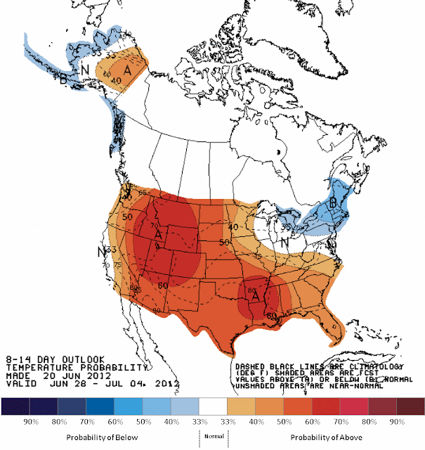
In fact this longer range outlook from the Climate Prediction Center places the center of above normal temperatures over our area

June 28-July 4 2012

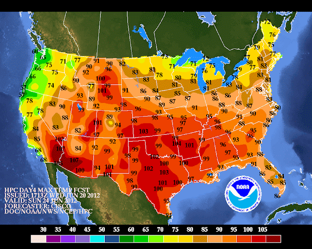
However it may seem hot by this weekend in Star Valley with our 80s and even low 90s, but it must be kept in perspective when looking at the expected temperatures in much of the  United States.`

Maximums for Sunday June 24  2012

Friday, June 15, 2012

How Warm Was It?

With the official start of summer 2012 just around the corner, it is of interest to review just what an unusually warm Spring it has been.  Most of us who were here in Star Valley  appreciated how soon the snow disappeared from the valley floor compared to just last year.  Gardening got off to a very early start with warm weather on many days even in April.

A fellow blogger who also is a meteorology professor at the University of Utah, Jim Steenburgh, recently blogged on how unusually warm it has been nationwide the past 3 months.  I found it quite interesting and want to share through Starvalleyweather.com

Here is a link to Jim's blog site

http://wasatchweatherweenies.blogspot.com/

and the following is the post on Jim's blog on this very warm period.


Wednesday, June 13, 2012

Spring Climate Summary

As many of you have probably seen in the news, it was a very hot spring (March, April, and May) in the contiguous United States.  As reported by the National Climatic Data Center, it was the warmest spring observed in contiguous U.S. since record keeping began in 1895 with an average temperature of 57.1ºF, 5.2ºF higher than the long term (1901–2000) average.  This spring eclipsed the previous warmest spring (1910) by 2.0ºF.  Many states recorded their all-time warmest spring.  Only Oregon and Washington observed near-average temperatures.
Source: NCDC
The spring statewide average temperature for Utah was the 8th highest on record.  Thus, it was a warm spring in Utah, but not unprecedented.  
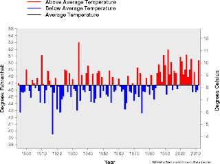
Spring (Mar-May) Utah Temperature
Source: NCDC
Records for Salt Lake City go back only to 1948, but show that this was the 2nd warmest spring on record.  Spring of 1992 was warmer, with an average temperature of 57.3ºF compared with 54.8ºF this spring.  
Spring (Mar-May) Salt Lake City Temperature
Source: NCDC 
The anomalously high spring temperatures on the heels of a dry winter are a primary cause of the high fire danger that exists across Utah and much of the southwest.  


Jim always post very interesting and educational discussions.

Tuesday, June 5, 2012

Rocky Mountain Storm Chase 2012

A long planned storm chase was taken by my son, Matt Hales, and I from June 1-4.  It appeared in advance that the pattern would not be particularly favorable for storm chasing in the High Plains.  Since we were limited on time the decision was made to at least see some of the great sites of the Rockies and what storms that we could.  The first day travel took us through Teton and Yellowstone NP and out the northeast entrance.  We  traveled across the Beartooth Pass which had just been reopened the day before.  Here are some pictures from on top preceded by one of the Tetons.


Day 2 was across southern Montana and northeast Wyoming to Spearfish SD.  While severe storms were hard to come by we did encounter great cloud shots after we left the Custer Battlefield in Montana.

Looking west from Custer Battlefield to approaching thunderstorm

Got a couple excellent shots as we traveled across northeast Wyoming along with the storm to Spearfish South Dakota.


On day 3 headed back to Billings as it looked like by the next day the best chance of any severe thunderstorms would be in far western Montana.  We intercepted a rather impressive thunderstorm toward sunset as we were heading back to Billings.


On day 4, June 4th we headed west and were able to get ahead of the development of a spectacular supercell that formed as thunderstorms moved off the higher mountains about 35 miles northwest of Helena Montana.  The following is a sequence of photos as the supercell formed.


While this spectacular supercell did not produce a tornado, very large hail up to baseball size and wind gusts to 90 mph occurred as it moved northeastward across the Great Falls area during the evening.

These  videos were taken on a high ridge looking south across the Dearborn River.  The storms were moving north from off  the higher terrain.  Our elevation was 4600 feet. The change in about 15 minutes was dramatic.