The Riverton Forecast Office has issued a video briefing for the weekend weather.
http://www.crh.noaa.gov/riw/?n=weatherbriefing
Thursday, January 31, 2013
January 2013 Summary
Star Valley's January was dominated by a cold and rather dry air mass for the first three weeks of the month, ending in several very snowy days. For the month, total snowfall was 28 inches reported by both the Thayne and Star Valley Ranch snow observers, with 22 inches measured by the Smoot Observer.
The snow pack in the mountains of Western Wyoming has improved by the recent snows and again are back to a near normal level.
The following graph of the Willow Creek Snotel, located in the Salt Range provides a comparison with both the snow water equivalent, total precipitation for this season with both the 2011-2012 season and the 30 year average.
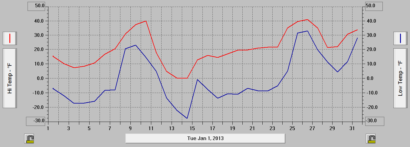
The following are the graphs from four Davis Weather Stations located in the Lower Star Valley showing the daily maximums and minimums.
.
The Thayne Elementary Solar insolation sensor graph shows that while cold, the first half of the month was generally sunny, compared to the last few days
The snow pack in the mountains of Western Wyoming has improved by the recent snows and again are back to a near normal level.
 | |
| Snow Water Equivalent |
The following graph of the Willow Creek Snotel, located in the Salt Range provides a comparison with both the snow water equivalent, total precipitation for this season with both the 2011-2012 season and the 30 year average.
 | ||
| Willow Creek Snotel |
 | |||
| Star Valley Ranch |
 |
| Thayne Elementary |
 | ||
| Etna Elementary |
 | |||||
| Double L Ranch |
 |
| Thayne ES Solar Insolation |
New Snow Totals
The latest round of snow across western Wyoming is summarized by the Forecast Office at Riverton.
PUBLIC INFORMATION STATEMENT
NATIONAL WEATHER SERVICE RIVERTON WY
834 PM MST WED JAN 30 2013

A STORM SYSTEM SLIDING SOUTHEAST...IN A MOIST NORTHWEST
FLOW...PRODUCED LIGHT TO MODERATE AMOUNTS OF SNOW ACROSS WESTERN
WYOMING...AS WELL AS THE NORTHERN BIGHORN MOUNTAINS AND ADJACENT
FOOTHILLS. BELOW ARE PRELIMINARY SNOWFALL TOTALS FROM LATE TUESDAY
NIGHT THROUGH EARLY WEDNESDAY EVENING.

NOTE...SNOTELS (SNOW TELEMETRY) ARE REMOTE SENSING SITES IN HIGH
MOUNTAIN WATERSHEDS.  SNOWFALL DATA FROM SNOTELS ARE ESTIMATED
BASED ON SNOW WATER EQUIVALENT.

LOCATION                             SNOWFALL

BIG HORN COUNTY...
 26 E LOVELL...                      16 INCHES.
 BALD MOUNTAIN SNOTEL...              6 INCHES.
 LOVELL...                          4-6 INCHES.
 GREYBULL...                        4-5 INCHES.
 6 ENE GREYBULL...                    4 INCHES.
 FRANNIE...                         3.5 INCHES.
 BONE SPRINGS DIVIDE SNOTEL...        3 INCHES.
 SHELL CREEK SNOTEL...                1 INCH.
 POWELL FIELD STATION...              1 INCH.

FREMONT COUNTY...
 BROOKS LAKE LODGE...                 5 INCHES.
 SOUTH PASS SNOTEL...                 4 INCHES.
 BURROUGHS CREEK SNOTEL...            3 INCHES.
 LITTLE WARM SNOTEL...                2 INCHES.
 COLD SPRINGS SNOTEL...               1 INCH.
 HOBBS PARK SNOTEL...                 1 INCH.
 DEER PARK SNOTEL...                  1 INCH.
 CASTLE CREEK SNOTEL...               1 INCH.

HOT SPRINGS COUNTY...
 OWL CREEK SNOTEL...                  3 INCHES.

JOHNSON COUNTY...
 LITTLE GOOSE SNOTEL...               4 INCHES.
 CLOUD PEAK RESERVOIR SNOTEL...       4 INCHES.
 HANSEN SAWMILL SNOTEL...             3 INCHES.
 BEAR TRAP MEADOW SNOTEL...           2 INCHES.
 BUFFALO...                         1.5 INCHES.
 SOLDIER PARK SNOTEL...               1 INCH.

LINCOLN COUNTY...
 WILLOW CREEK SNOTEL...              12 INCHES.
 SPRING CREEK DIVIDE SNOTEL...        9 INCHES.
 COTTONWOOD CREEK SNOTEL...           8 INCHES.
 AFTON...                             8 INCHES.
 ALPINE...                            8 INCHES.
 BOX Y RANCH...                       8 INCHES.
 BEDFORD...                           8 INCHES.
 SALT RIVER SUMMIT SNOTEL...          7 INCHES.
 3 W AFTON...                         5 INCHES.
 INDIAN CREEK SNOTEL...               5 INCHES.
 BLIND BULL SUMMIT...                 4 INCHES.
 BLIND BULL SUMMIT SNOTEL...          4 INCHES.
 HAMS FORK SNOTEL...                  4 INCHES.
 KELLEY RANGER STATION SNOTEL...      4 INCHES.

NATRONA COUNTY...
 GRAVE SPRING SNOTEL...               3 INCHES.

PARK COUNTY...
 WOLVERINE SNOTEL...                  5 INCHES.
 3 SW FRANNIE...                    4.5 INCHES.
 MARQUETTE SNOTEL...                  4 INCHES.
 EVENING STAR SNOTEL...               4 INCHES.
 BEARTOOTH LAKE SNOTEL...             4 INCHES.
 YOUNTS PEAK SNOTEL...                1 INCH.
 BLACKWATER SNOTEL...                 1 INCH.
 TIMBER CREEK SNOTEL...               1 INCH.

SUBLETTE COUNTY...
 TRIPLE PEAK SNOTEL...                7 INCHES.
 SNIDER BASIN SNOTEL...               7 INCHES.
 LARSEN CREEK SNOTEL...               5 INCHES.
 LOOMIS PARK SNOTEL...                5 INCHES.
 POCKET CREEK SNOTEL...               4 INCHES.
 BIG SANDY OPENING SNOTEL...          4 INCHES.
 NEW FORK LAKE SNOTEL...              4 INCHES.
 ELKHART PARK G.S. SNOTEL...          4 INCHES.
 EAST RIM DIVIDE SNOTEL...            4 INCHES.
 GUNSITE PASS SNOTEL...               3 INCHES.

TETON COUNTY...
 JACKSON HOLE-RAYMER...              10 INCHES.
 GRASSY LAKE SNOTEL...                8 INCHES.
 PHILLIPS BENCH SNOTEL...             8 INCHES.
 JACKSON HOLE-MID...                  6 INCHES.
 TOGWOTEE PASS SNOTEL...              5 INCHES.
 GRANITE CREEK SNOTEL...              5 INCHES.
 SNAKE RIVER STN SNOTEL...            3 INCHES.
 BASE CAMP SNOTEL...                  3 INCHES.
 GRAND TARGHEE SNOTEL...              3 INCHES.
 MORAN...                             3 INCHES.
 GROS VENTRE SUMMIT SNOTEL...         3 INCHES.
 JACKSON HOLE-BASE...                 2 INCHES.
 2 NW JACKSON...                      2 INCHES.
 JACKSON...                         1.5 INCHES.

WASHAKIE COUNTY...
 MIDDLE POWDER SNOTEL...              4 INCHES.
 POWDER RIVER PASS SNOTEL...          2 INCHES.

YELLOWSTONE NATIONAL PARK...
 SYLVAN LAKE SNOTEL...                6 INCHES.
 PARKER PEAK SNOTEL...                6 INCHES.
 SYLVAN ROAD SNOTEL...                4 INCHES.
 THUMB DIVIDE SNOTEL...               4 INCHES.
 TWO OCEAN PLATEAU SNOTEL...          4 INCHES.
 LEWIS LAKE DIVIDE SNOTEL...          3 INCHES.
 CANYON SNOTEL...                     1 INCH.
Monday, January 28, 2013
Snowfall Amounts in Wyoming
Snowfall Totals - Sunday through early Monday
The first in a series of winter storms early this week brought significant snowfall across portions of western and northern Wyoming Sunday into Monday morning. Below are preliminary snowfall totals across western and central Wyoming. The highest snowfall amounts occurred in Star Valley and in the northern Teton Mountains.
| County | Station Name | Snowfall |
|---|---|---|
| Big Horn | 26 E Lovell | 9 |
| Big Horn | Bald Mountain Snotel | 6 |
| Big Horn | Bone Springs Divide Snotel | 5 |
| Big Horn | Shell Creek Snotel | 5 |
| Big Horn | Shell | 4 |
| Big Horn | Lovell | 3.5 |
| Big Horn | 2 SSW Lovell | 3 |
| Big Horn | Greybull | 1-2 |
| Big Horn | Basin | 1.5 |
| County | Station Name | Snowfall |
| Fremont | Hobbs Park Snotel | 3 |
| Fremont | Little Warm Snotel | 3 |
| Fremont | Dubois | 1-2 |
| Fremont | Brooks Lake Lodge | 2 |
| Fremont | Cold Springs Snotel | 2 |
| Fremont | Riverton | 0.9 |
| Fremont | Lander Airport | 0.6 |
| County | Station Name | Snowfall |
| Hot Springs | 1 SW Thermopolis | 4 |
| Hot Springs | Kirby | 2.5 |
| Hot Springs | 8 W Thermopolis | 2.5 |
| Hot Springs | 9 NE Thermopolis | 1.6 |
| Hot Springs | 11 N Thermopolis | 1.25 |
| County | Station Name | Snowfall |
| Johnson | Little Goose Snotel | 5 |
| Johnson | Soldier Park Snotel | 5 |
| Johnson | Buffalo | 3-4 |
| Johnson | 4 SSW Buffalo | 3.5 |
| Johnson | Cloud Peak Reservoir Snotel | 3 |
| Johnson | Bear Trap Meadow Snotel | 2 |
| Johnson | Hansen Sawmill Snotel | 2 |
| Johnson | Kaycee | 1 |
| County | Station Name | Snowfall |
| Lincoln | 2 SE Thayne | 10.5 |
| Lincoln | Smoot | 8 |
| Lincoln | Willow Creek Snotel | 8 |
| Lincoln | 5 NNE Thayne | 8 |
| Lincoln | 5 SSE Smoot | 7 |
| Lincoln | Blind Bull Summit Snotel | 5 |
| Lincoln | Kelley Ranger Station Snotel | 5 |
| Lincoln | Spring Creek Divide Snotel | 5 |
| Lincoln | Cottonwood Creek Snotel | 5 |
| Lincoln | 1 W Smoot | 4 |
| Lincoln | Alpine | 4 |
| Lincoln | Commissary Ridge | 2 |
| Lincoln | Salt River Summit Snotel | 2 |
| Lincoln | Box Y Ranch | 2 |
| Lincoln | Kemmerer | 1 |
| Lincoln | 1 SW Kemmerer | 0.5 |
| County | Station Name | Snowfall |
| Natrona | Casper Mountain Snotel | 5 |
| Natrona | 2 S Casper | 2.3 |
| Natrona | Grave Spring Snotel | 2 |
| Natrona | Casper Airport | 1.7 |
| Natrona | 10 WSW Casper | 1.5 |
| Natrona | 4 WSW Casper | 1.5 |
| Natrona | 3 NNE Casper | 1.2 |
| County | Station Name | Snowfall |
| Park | Timber Creek Snotel | 8 |
| Park | Wolverine Snotel | 8 |
| Park | Blackwater Snotel |
8 |
| Park | Beartooth Lake Snotel |
6 |
| Park | Evening Star Snotel |
6 |
| Park | 3 NE Sunshine | 5.5 |
| Park | Marquette Snotel |
5 |
| Park | Pahaska | 3 |
| Park | 5 ESE Cody | 3 |
| Park | 1 NE Wapiti | 3 |
| Park | Meeteetse | 2.4 |
| Park | 2 WSW Cody | 2 |
| Park | 1 WNW Cody | 1.1 |
| Park | Cody | 1 |
| Park | Powell | 1 |
| Park | 3 SW Frannie | 1 |
| Park | Clark | 0.5 |
| County | Station Name | Snowfall |
| Sublette | Kendall Ranger Station Snotel | 6 |
| Sublette | East Rim Divide Snotel | 6 |
| Sublette | Gunsite Pass Snotel | 5 |
| Sublette | 14 NW Pinedale | 3.3 |
| Sublette | New Fork Lake Snotel | 3 |
| Sublette | Loomis Park Snotel | 3 |
| Sublette | Snider Basin Snotel | 2 |
| Sublette | Triple Peak Snotel | 2 |
| Sublette | Bondurant | 1.3 |
| Sublette | Marbleton | 1 |
| County | Station Name | Snowfall |
| Teton | Grand Targhee-Chief Joseph | 21 |
| Teton | Grand Targhee Snotel | 11 |
| Teton | Jackson Hole-Rendezvous Bowl | 10 |
| Teton | Jackson Hole-Raymer | 9 |
| Teton | 1 NNW Alta | 8 |
| Teton | Togwotee Mountain Lodge | 8 |
| Teton | Moose | 6 |
| Teton | Jackson Hole-Mid | 5 |
| Teton | Gros Ventre Summit Snotel | 5 |
| Teton | Snow King Ski Area | 5 |
| Teton | 4 S Jackson | 4.5 |
| Teton | Jackson | 4 |
| Teton | Moose | 4 |
| Teton | 2 NE Teton Village | 3 |
| Teton | Togwotee Pass Snotel | 3 |
| Teton | Snake River Stn Snotel | 3 |
| Teton | Phillips Bench Snotel | 3 |
| Teton | Granite Creek Snotel | 3 |
| Teton | Grassy Lake Snotel | 3 |
| Teton | Jackson Hole-Base | 2 |
| Teton | Base Camp Snotel | 2 |
| County | Station Name | Snowfall |
| Washakie | 5 NNW Ten Sleep | 3.5 |
| Washakie | Powder River Pass Snotel | 3 |
| Washakie | Ten Sleep | 2 |
| Washakie | 16 SSE Ten Sleep | 2 |
| Washakie | 27 S Ten Sleep | 1.6 |
| Washakie | Worland | 0.5 |
| County | Station Name | Snowfall |
| Yellowstone | Sylvan Lake Snotel |
8 |
| Yellowstone | Parker Peak Snotel | 6 |
| Yellowstone | Two Ocean Plateau Snotel | 6 |
| Yellowstone | Thumb Divide Snotel | 5 |
| Yellowstone | Yellowstone East Entrance | 3 |
| Yellowstone | Lamar Ranger Station | 3 |
| Yellowstone | Tower Falls Ranger Station | 1.1 |
| County | Station Name | Snowfal |
Thursday, January 24, 2013
Colder Air to Return Next Week?
Temperatures finally climbed above freezing across Star Valley Thursday for the first time in two weeks. Here is the weekly weather summary issued by the Riverton Forecast Office, highlighting the possible return of cold weather next week.
http://www.crh.noaa.gov/riw/?n=weatherbriefing
http://www.crh.noaa.gov/riw/?n=weatherbriefing
Monday, January 21, 2013
Wyoming SnowPack/Water Supply Outlook
Here is the first Wyoming Water Supply Outlook for this Water Year. Note that the conditions are best in Western Wyoming(Star Valley region), where snowpack is near normal. However the current dry pattern is cutting into the favorable beginning of the Winter Snow Season.
Initial Wyoming Water Supply Outlook---issued January 15, 2013
...Current water year precipitation is averaging nearly 85 percent of normal across Wyoming…
…Mountain snowpack across Wyoming is 80 to 85 percent of average...
…Above normal streamflow volumes are expected across northwestern Wyoming watersheds...
…Wyoming reservoir storages are near average for January…
Current water year precipitation across Wyoming is nearly 85 percent of average. Precipitation numbers vary between 117 percent of normal over the Upper Yellowstone Basin to 54 percent of normal over the Belle Fourche Drainage.
Above normal (100 to 115
percent) snowmelt streamflow volumes are expected across major basins
across northwestern Wyoming---which includes the Upper Yellowstone, the
Snake, and the Shoshone Watersheds.
Reservoirs storages across Wyoming are near average for January.
The latest Wyoming water supply outlook graphic:

Monday, January 14, 2013
Cold!!!!!!!!!!!!!!!!!
It was even colder across much of the mountain west this Monday morning, than on Sunday. Following is a list of observed minimums:
Thayne ES -28
Double L Ranch -27
Etna ES -21
Osmond ES -21
Smoot -21
Afton -18
Alpine -17
Star Valley Ranch -14
Two reports from Auburn from truck thermometers reported -30
Other Reports
Peter Sink UT -46
Hog Park WY (near Encampment) -42
Maybell CO -41
Albany WY -41
13 W Kemmerer WY -36
Bondurant WY -34
Driggs ID -33
West Yellowstone MT -33
South Park(Jackson0 WY -32
Pinedale WY -31
Box Y Ranch -29
Idaho Falls -20
Salt River Summit -14
Pocatello -13
As cold as it was here in Star Valley, it could have been even colder if it had not been for cloud cover for part of the night. Note from the temperature trace on the Thayne ES station, that from before midnight until 6am temperatures did not drop. And then just prior to sunrise the clouds disappeared and the mercury plummeted to the final low of -28 just prior to 9am.
 |
| Thayne Elementary School temperature Saturday 01/12/13 to Monday 01/14/13. |
Sunday, January 13, 2013
Cold!!
Clouds cleared overnight allowing temperatures across Star Valley to plummet. Here is a list of recorded minimums this Sunday morning.
Thayne ES -22
Double L Ranch (4 NW of Etna) -20
Osmond ES -17
Smoot -17
Etna ES -16
2 NE Etna -16
Alpine -15
Star Valley Ranch -10
Other nearby locations
West Yellowstone MT -38
Yellowstone Lake WY -36
Driggs ID -28
Bondurant -28
Farson -25
Box Y Ranch -25
The very cold upper trough will remain over the area through Monday, with another possibly colder night on tap for Western Wyoming. If skies remain generally clear, conditions will be favorable for minimums to be another 5 degrees colder Monday morning.
High pressure will dominate much of the west through the coming week, so little additional snow is expected until at least next weekend across Star Valley. Nights will continue below zero, with a slow daytime warming trend after Monday.
Saturday, January 12, 2013
Utah Wasatch Front Buried in Snow
The snow has stopped in Northern Utah after producing very impressive, near record, accumulations along much of the Wasatch Front . Following is the latest storm update from the Salt Lake City Forecast Office.
 |
| Bountiful Utah |
PUBLIC INFORMATION STATEMENT...UPDATED
 NATIONAL WEATHER SERVICE SALT LAKE CITY UT
 320 PM MST SAT JAN 12 2013

 ...PRELIMINARY STORM INFORMATION...

 A COLD PACIFIC STORM SYSTEM BROUGHT PERIODS OF HEAVY SNOWFALL BEGINNING
 THURSDAY AFTERNOON. BELOW ARE SNOWFALL AND PRECIPITATION TOTALS RECEIVED
 THROUGH 300 PM SATURDAY.

 ***** PRECIP REPORTS *****                TIME        SNOW     PRECIP

 ...CACHE VALLEY/UTAH PORTION...
 PROVIDENCE - 4528 FT                     8 AM SAT      7.0      0.36
 NORTH LOGAN - 4749 FT                    8 AM SAT      6.2      0.32
 LOGAN - 4515 FT                          7 AM SAT      5.0      0.26
 RICHMOND - 4576 FT                       7 AM FRI      3.2      0.44

 ...NORTHERN WASATCH FRONT...
 2 E BOUNTIFUL                            5 PM FRI     34.0
 CENTERVILLE - 4445 FT                    2 PM SAT     32.0      1.81
 CENTERVILLE - 4346 FT                    7 AM SAT     25.0      1.39
 BOUNTIFUL - 5085 FT                      8 AM SAT     24.3      0.92
 WOODS CROSS                              5 PM FRI     21.0
 SOUTH OGDEN - 4780 FT                    9 AM SAT     19.0      1.03
 FARMINGTON - 4239 FT                    10 AM SAT     18.3      0.67
 CLEARFIELD                               5 PM FRI     18.0
 HILL AIR FORCE BASE - 4787 FT            5 PM FRI     18.0
 NORTH SALT LAKE                         10 AM FRI     18.0
 EAST LAYTON                              8 AM FRI     18.0
 1 W LAYTON                               5 PM FRI     16.0
 CLEARFIELD - 4260 FT                     8 AM SAT     15.2
 BOUNTIFUL                                5 PM FRI     15.0
 NORTHEAST OGDEN BENCH - 4560 FT          8 AM SAT     13.6      0.98
 BRIGHAM CITY - 4364 FT                   6 AM SAT     13.0      0.84
 FARMINGTON                               5 PM FRI     13.0
 LAYTON - 4460 FT                         5 PM FRI     13.0      0.74
 PERRY - 4491 FT                          6 AM SAT     12.5
 BRIGHAM CITY                            10 AM SAT     12.0
 ROY                                      5 PM FRI     12.0
 CLINTON                                  5 PM FRI     12.0
 FRUIT HEIGHTS                           11 AM FRI     12.0      0.75
 WEST PT                                  8 AM FRI     12.0
 WEST HAVEN - 4239 FT                     7 AM SAT     11.0      0.60
 NORTH OGDEN - 4392 FT                    7 AM SAT     10.0      0.54
 WEST WEBER - 4248 FT                     7 AM SAT      9.9      0.37
 SYRACUSE                                 8 AM FRI      9.0
 CENTERVILLE                              8 PM THU      8.0
 GARLAND 1 SE - 4328 FT                   7 AM SAT      4.5      0.21
 BOUNTIFUL - 4760 FT                     11 AM SAT               1.43
 BOUNTIFUL BENCH - 4990 FT               11 AM SAT               1.23

 ...SALT LAKE AND TOOELE VALLEYS...
 UPPER MILLCREEK - 5050 FT               10 AM SAT     34.0      1.47
 4 SE SALT LAKE CITY                     10 AM SAT     21.7      1.31
 SALT LAKE CITY 4.5 SE - 4655 FT          9 AM SAT     21.7      1.31
 UPPER AVENUES - 5000 FT                  6 AM SAT     20.0
 OLYMPUS HILLS - MSI - 4960 FT            5 PM FRI     20.0      0.64
 HOLLADAY - 4540 FT                       7 AM SAT     19.2      1.10
 EAST MILLCREEK                           9 AM FRI     19.0
 COTTONWOOD HEIGHTS - 5138 FT             7 AM SAT     17.5      1.06
 SALT LAKE CITY                          12 PM FRI     15.0      0.69
 SOUTH SALT LAKE - 4272 FT                1 PM SAT     14.2      0.97
 5 SE SALT LAKE CITY                      8 AM FRI     13.2
 SALT LAKE INTL AIRPORT - 4226 FT        11 AM SAT     10.2      0.58
 TOOELE - 5070 FT                         5 PM FRI      9.0      0.71
 SANDY - 4852 FT                          7 AM SAT      8.5      0.62
 MAGNA - 4319 FT                          7 AM SAT      8.4      0.78
 WEST VALLEY CITY - 4317 FT               8 AM SAT      7.2      0.49
 STANSBURY PARK - 4300 FT                 6 PM THU      6.0
 TAYLORSVILLE - 4482 FT                   7 AM SAT      5.3      0.32
 STOCKTON - 5087 FT                       7 AM FRI      5.0      0.49
 DRAPER 2 WNW - 4427 FT                   7 AM SAT      4.8      0.01
 WEST JORDAN - 4722 FT                    9 AM FRI      1.5      0.09
 OLYMPUS COVE - 5036 FT                   7 AM FRI               0.92
 NORTH HOLLADAY - 4600 FT                11 AM SAT               0.90

 ...SOUTHERN WASATCH FRONT...
 ELK RIDGE                                8 AM FRI     22.0
 PAYSON                                  10 AM SAT     20.0
 PAYSON                                   5 PM FRI     16.0
 SUNCREST - 6140 FT                       8 PM FRI      6.0
 ALPINE - 5070 FT                         5 PM FRI      6.0      0.31
 SPRINGVILLE - 4545 FT                    5 PM FRI      6.0      0.38
 LEHI - 4800 FT                           7 AM SAT      3.5      0.20

 ...GREAT SALT LAKE DESERT AND MOUNTAINS...
 UTAH TEST RANGE - 4440 FT                5 PM FRI      1.0      0.11
 DRY FORK - 7160 FT                      10 AM SAT               1.70
 MINING FORK - 8000 FT                   10 AM SAT               1.30
 ROCKY BASIN-SETTLEME - 8900 FT          10 AM SAT               1.20

 ...WASATCH MOUNTAIN VALLEYS...
 LIBERTY                                  8 PM FRI     28.0
 EDEN                                    10 AM SAT     12.0
 HEBER CITY - 5768 FT                     8 AM SAT      7.5      0.30
 MORGAN - 5092 FT                         8 AM SAT      4.9      0.30
 DEER CREEK DAM - 5270 FT                 5 AM FRI      4.0      0.15

 ...WASATCH MOUNTAINS I-80 NORTH...
 EMIGRATION CANYON                        9 AM SAT     32.0
 SNOWBASIN-MID. BOWL - 7402 FT            5 AM SAT     26.0      1.14
 POWDER MOUNTAIN                          5 AM SAT     16.0
 SUMMIT PARK                              7 AM SAT     14.0
 FARMINGTON - 8000 FT                    10 AM SAT               3.60
 PARRISH CREEK - 7740 FT                 10 AM SAT               3.20
 LOUIS MEADOW - 6700 FT                  10 AM SAT               2.60
 FARMINGTON LOWER - 6779 FT              10 AM SAT               2.30
 LOOKOUT PEAK - 8200 FT                  10 AM SAT               1.80
 PARLEYS SUMMIT - 7500 FT                10 AM SAT               1.50
 BEN LOMOND PEAK - 8000 FT               10 AM SAT               1.10

 ...WASATCH MOUNTAINS SOUTH OF I-80...
 SNOWBIRD - 8100 FT                      12 AM SAT     21.0      1.39
 BRIGHTON CREST - 9500 FT                 4 AM SAT     15.0      1.12
 THE CANYONS - 8800 FT                    5 AM SAT     14.0      0.79
 ALTA UDOT - 8799 FT                      4 AM SAT     13.0      0.91
 ALTA COLLINS - 9662 FT                  11 AM SAT     13.0      0.89
 BIG COTTONWOOD SPRUCES - 7402 FT         6 AM SAT     12.0      0.92
 SOLITUDE - 8200 FT                       5 AM SAT     11.0      0.94
 DEER VALLEY DALY WEST - 8200 FT          4 PM FRI     10.0      0.09
 PARK CITY SUMMIT - 9300 FT               5 AM SAT      9.0      0.65
 PROVO CANYON - 6100 FT                   5 AM SAT      8.0      0.41
 BIG COTTONWOOD ROCK HOUSE - 6800 FT      6 AM FRI      5.5      0.45
 MID MOUNTAIN - 7450 FT                  11 AM SAT               1.48
 MILL-D NORTH - 8960 FT                  10 AM SAT               1.20
 CASCADE MOUNTAIN - 7768 FT              10 AM SAT               1.10

 ...WESTERN UINTA MOUNTAINS...
 EF BLACKS FORK GS - 9308 FT             10 AM SAT               0.90
 SMITH & MOREHOUSE - 7600 FT             10 AM SAT               0.70
 CHALK CREEK #2 - 8200 FT                10 AM SAT               0.70
 CHALK CREEK #1 - 9100 FT                10 AM SAT               0.70
 BEAVER DIVIDE - 8280 FT                 10 AM SAT               0.60
 LAKEFORK BASIN - 10900 FT                3 PM FRI               0.60
 FIVE POINTS LAKE - 10920 FT              5 AM FRI               0.60
 WEST FORK BLACKSMITHS FORK - 9620 FT     5 PM FRI               0.53
 ASPEN MTN - 7539 FT                     10 AM FRI               0.51
 HAYDEN FORK - 9100 FT                    5 PM FRI               0.50
 SPIRIT LAKE - 10223 FT                  11 AM FRI               0.50
 CURRANT CREEK - 8000 FT                  4 AM FRI               0.50

 ...WASATCH PLATEAU/BOOK CLIFFS...
 STRAWBERRY DIVIDE - 8400 FT             10 AM SAT               1.40
 CLEAR CREEK #1 - 9200 FT                 5 PM FRI               1.10
 CLEAR CREEK #2 - 8300 FT                10 AM SAT               1.00
 DANIELS-STRAWBERRY - 8000 FT             4 PM FRI               1.00

 ...WESTERN UINTA BASIN...
 ROOSEVELT - 5167 FT                      8 AM FRI               0.50

 ...CASTLE COUNTRY...
 WELLINGTON 3 E - 5400 FT                 5 PM FRI      2.0      0.12
 FERRON - 5930 FT                         5 AM FRI      0.3

 ...SAN RAFAEL SWELL...
 HANS FLAT RS - 6600 FT                   5 AM FRI      1.3      0.08
 CAPITOL REEF NATIONAL PARK - 5500 FT     5 AM FRI      0.7

 ...SANPETE/SEVIER VALLEYS...
 SPRING CITY - 5835 FT                   10 AM FRI               0.19

 ...WEST CENTRAL UTAH...
 FILLMORE - 5120 FT                       5 PM FRI     10.5      0.84
 OAK CITY                                 9 PM THU      7.0      0.60
 DELTA                                    9 PM THU      6.0

 ...SOUTHWEST UTAH...
 CEDAR CITY                              10 AM FRI      3.0      0.30
 NEW HARMONY - 5625 FT                    5 AM FRI      0.4      0.05
 CEDAR CITY MUNICIPAL AIRPORT - 5627 FT  10 AM FRI               0.18

 ...UTAH`S DIXIE AND ZION NATIONAL PARK...
 ST. GEORGE 1.7 SW - 2554 FT              8 AM SAT               0.13

 ...SOUTH CENTRAL UTAH...
 KODACHROME BASIN PARK - 5810 FT          5 PM FRI      2.5      0.08
 APPLE VALLEY - 4757 FT                   8 AM FRI      0.5      0.03

 ...GLEN CANYON RECREATION AREA/LAKE POWELL...
 BIG WATER - 4100 FT                      5 AM FRI      0.3      0.03

 ...CENTRAL UTAH MOUNTAINS...
 PINE CREEK - 8800 FT                     5 PM FRI               1.50
 OAK CREEK - 7772 FT                     10 AM SAT               0.70
 PICKLE KEG - 9600 FT                    10 AM SAT               0.70
 FARNSWORTH LAKE - 9600 FT               10 AM SAT               0.60
 SEELEY CREEK - 10000 FT                  9 AM FRI               0.60
 BUCK FLAT - 9800 FT                     10 AM SAT               0.50

 ...SOUTHERN UTAH MOUNTAINS...
 9 S BEAVER                               9 PM THU      5.0
 PAROWAN                                  9 PM THU      4.0
 18 NW PANGUITCH                          9 PM THU      4.0
 1 NE CEDAR CITY                          8 PM THU      3.0
 BRYCE CANYON                             9 AM FRI      2.0
 PANGUITCH - 6630 FT                      5 AM FRI      1.0      0.02
 BOULDER - 7171 FT                        6 AM FRI      0.4      0.03
 KIMBERLY MINE - 9300 FT                 10 AM SAT               1.10
 MERCHANT VALLEY - 8750 FT               10 AM SAT               0.60
 CLAYTON SPRINGS - 10000 FT               5 PM FRI               0.50
 JONES CORRAL - 9751 FT                   9 AM FRI               0.50
Friday, January 11, 2013
Snow Results
 |
| Star Valley Ranch Friday Afternoon |
The storm so far has resulted in from 1-6 inches of new snow across Star Valley. While flurries could produce another inch of two by Saturday morning, cold is going to be the main story over the weekend. Temperatures will be dropping well below zero by Saturday night, and only rise into the single digits during the afternoons. The typically coldest valley locations could dip below 20 below again as happened a couple weeks ago. The cloud cover will provide some insulation tonight, but less likely the next couple nights.
Snow fall amounts from the storm thus far in Western Wyoming are listed below:
| County | Station Name | Snowfall |
|---|---|---|
| Big Horn | 2 SSW Lovell |
4
|
| Big Horn | Bone Springs Divide Snotel |
3
|
| Big Horn | Bald Mountain Snotel |
3
|
| Big Horn | 6 E Lovell |
2
|
| Big Horn | Shell Creek Snotel |
2
|
| Big Horn | Greybull |
1
|
| Fremont | Castle Creek Snotel | 9 |
| Fremont | 1 SE Lander | 8.5 |
| Fremont | 5 WSW Lander | 8 |
| Fremont | 3 SW Lander | 7.5 |
| Fremont | 9.5 SW Lander | 7 |
| Fremont | Hobbs Park Snotel | 6 |
| Fremont | Cold Springs Snotel | 6 |
| Fremont | Fort Washakie | 4-6 |
| Fremont | Dubois | 5 |
| Fremont | Little Warm Snotel | 5 |
| Fremont | Burroughs Creek Snotel | 5 |
| Fremont | 6 SW Lander | 5 |
| Fremont | Hudson | 5 |
| Fremont | Lander Airport | 4.8 |
| Fremont | Brooks Lake Lodge | 4 |
| Fremont | Jeffrey City | 3.5 |
| Fremont | Deer Park Snotel | 3 |
| Fremont | Townsend Creek Snotel | 3 |
| Fremont | 1 W Lander | 3 |
| Fremont | Riverton | 2.5 |
| Fremont | South Pass Snotel | 2 |
| Fremont | Diversion Dam | 1.5 |
| Fremont | 6 SE Lander | 1 |
| Fremont | 9 SSE Lander | 0.3 |
| Hot Springs | Owl Creek Snotel |
5
|
| Hot Springs | Thermopolis |
3.75
|
| Hot Springs | 1 SW Thermopolis |
2.5
|
| Johnson | 7 N Kaycee | 2.5 |
| Johnson | Hansen Sawmill Snotel | 2 |
| Johnson | Soldier Park Snotel | 2 |
| Johnson | Cloud Peak Reservoir Snotel | 2 |
| Johnson | 17 E Kaycee | 0.5 |
| Johnson | 4 SSW Buffalo | 0.5 |
| Johnson | Buffalo | 0.3 |
| Lincoln | Kemmerer |
6
|
| Lincoln | Turnerville |
6
|
| Lincoln | 5 NNE Thayne |
4
|
| Lincoln | Afton |
3
|
| Lincoln | 5 SSE Smoot |
3
|
| Lincoln | Salt River Summit Snotel |
3
|
| Lincoln | Cottonwood Creek Snotel |
3
|
| Lincoln | Commissary Ridge |
3
|
| Lincoln | 1 W Smoot |
3
|
| Lincoln | Willow Creek Snotel |
3
|
| Lincoln | Alpine |
1-2
|
| Lincoln | Hams Fork Snotel |
2
|
| Lincoln | Indian Creek Snotel |
2
|
| Lincoln | Kelley Ranger Station Snotel |
2
|
| Lincoln | Kemmerer |
2
|
| Lincoln | Blind Bull Summit Snotel |
2
|
| Lincoln | 2 SE Thayne |
1.4
|
| Lincoln | 2 NE Freedom |
1
|
| Lincoln | Blind Bull Summit |
1
|
| Lincoln | Box Y Ranch |
1
|
| Natrona | 15 W Midwest | 3 |
| Natrona | Grave Spring Snotel | 3 |
| Natrona | Hiland | 2 |
| Natrona | 4 SW Casper | 2 |
| Natrona | Casper | 0.5-1 |
| Natrona | 2 E Evansville | 1 |
| Natrona | Powder River School | 1 |
| Natrona | 8 NE Alcova | 1 |
| Natrona | Midwest | 0.4 |
| Park | Meeteetse |
5-7
|
| Park | 5 ESE Cody |
4.6
|
| Park | 2 WSW Cody |
4
|
| Park | Marquette Snotel |
3
|
| Park | Blackwater Snotel |
3
|
| Park | Evening Star Snotel |
2
|
| Park | Younts Peak Snotel |
2
|
| Park | 1 WNW Cody |
2
|
| Park | Timber Creek Snotel |
2
|
| Park | Beartooth Lake Snotel |
2
|
| Park | 4 SE Cody |
0.5
|
| Sublette | Pocket Creek Snotel | 9 |
| Sublette | Elkhart Park G.S. Snotel | 9 |
| Sublette | Pinedale | 8 |
| Sublette | New Fork Lake Snotel | 8 |
| Sublette | Larsen Creek Snotel | 8 |
| Sublette | Big Sandy Opening Snotel | 8 |
| Sublette | Gunsite Pass Snotel | 6 |
| Sublette | Marbleton | 6 |
| Sublette | East Rim Divide Snotel | 6 |
| Sublette | Pinedale | 6 |
| Sublette | Loomis Park Snotel | 5 |
| Sublette | Kendall Ranger Station Snotel | 5 |
| Sublette | Boulder | 4.5 |
| Sublette | 8 N Daniel | 4.5 |
| Sublette | Merna | 3 |
| Sublette | Snider Basin Snotel | 3 |
| Sublette | 14 NW Pinedale | 2.2 |
| Sublette | Triple Peak Snotel | 2 |
| Sweetwater | Farson |
3-5.5
|
| Sweetwater | Rock Springs |
0.4-0.7
|
| Sweetwater | 3 NW Green River |
0.5
|
| Teton | Grassy Lake Snotel | 11 |
| Teton | Grand Targhee Ski Area | 11 |
| Teton | Jackson Hole-Rendezvous Bowl | 8 |
| Teton | Gros Ventre Summit Snotel | 8 |
| Teton | Grand Targhee Snotel | 8 |
| Teton | Grand Targhee-Chief Joseph | 6 |
| Teton | Jackson Hole-Mid | 4 |
| Teton | 12 NE Jackson | 4 |
| Teton | Jackson Hole-Raymer | 4 |
| Teton | Moose | 4 |
| Teton | 2 NE Teton Village | 3 |
| Teton | Jackson Hole-Base | 3 |
| Teton | Togwotee Mountain Lodge | 3 |
| Teton | Togwotee Pass Snotel | 3 |
| Teton | 1 ENE Teton Village | 2.3 |
| Teton | Granite Creek Snotel | 2 |
| Teton | Base Camp Snotel | 2 |
| Teton | Snow King Ski Area | 1 |
| Washakie | Middle Powder Snotel |
5
|
| Washakie | Worland |
3-4
|
| Washakie | 1 W Worland |
1.5
|
| Washakie | 5 NNW Ten Sleep |
0.9
|
| Yellowstone | Thumb Divide Snotel | 8 |
| Yellowstone | Parker Peak Snotel | 8 |
| Yellowstone | Lewis Lake Divide Snotel | 8 |
| Yellowstone | Two Ocean Plateau Snotel | 3 |
| Yellowstone | Canyon Snotel | 3 |
| Yellowstone | Sylvan Road Snotel | 2 |
| Yellowstone | Sylvan Lake Snotel | 2 |
Much greater amounts have occurred in Northern Utah along the Wasatch Front.
The link below list some impressive snowfalls!
http://www.wrh.noaa.gov/total_forecast/getprod.php?wfo=slc&sid=SLC&pil=PNS
Subscribe to:
Posts (Atom)