Tuesday, January 31, 2017

PERSISTENT SNOW TO IMPACT NORTHWEST WYOMING TODAY THROUGH WEDNESDAY EVENING


Model Forecast of Total Snowfall to Wednesday Evening


...PERSISTENT SNOW TO IMPACT NORTHWEST WYOMING TODAY THROUGH
WEDNESDAY EVENING...

.A MOIST NORTHWEST FLOW ALOFT WILL PROVIDE SUFFICIENT UPSLOPE
FLOW ACROSS PORTIONS OF NORTHWEST WYOMING THIS MORNING THROUGH
WEDNESDAY NIGHT. SNOWFALL WILL BE HEAVY AT TIMES. BLOWING SNOW
WITH SOUTHWEST WINDS GUSTING UP TO 40 MPH ARE ALSO EXPECTED IN THE
HIGHER ELEVATIONS TODAY THROUGH WEDNESDAY.


STAR VALLEY-
INCLUDING THE CITIES OF...AFTON...ALPINE...STAR VALLEY RANCH...
THAYNE
459 AM MST TUE JAN 31 2017

...WINTER WEATHER ADVISORY IN EFFECT FROM 5 PM TUESDAY TO 5 PM
MST WEDNESDAY...

THE NATIONAL WEATHER SERVICE IN RIVERTON HAS ISSUED A WINTER
WEATHER ADVISORY FOR SNOW...WHICH IS IN EFFECT FROM 5 PM TODAY TO
5 PM MST WEDNESDAY.

* TIMING...SNOWFALL WILL MOVE IN FROM THE NORTH LATER THIS
  AFTERNOON AND SHOULD BE WELL UNDERWAY AFTER 5 PM. SNOWFALL WILL
  BE MODERATE AT TIMES OVER NORTHERN PORTIONS OF THE VALLEY
  THROUGH THE PERIOD.

* SNOWFALL TOTALS...3 TO 4 INCHES NEAR AFTON AND 6 TO 8 INCHES
  NEAR ALPINE.

* MAIN IMPACT...ROADS AND HIGHWAYS WILL BE SLICK AND SNOW PACKED
  AND TRAVEL WILL BE DIFFICULT AT TIMES.

PRECAUTIONARY/PREPAREDNESS ACTIONS...

A WINTER WEATHER ADVISORY FOR SNOW MEANS PERIODS OF SNOW WILL
CAUSE PRIMARILY TRAVEL DIFFICULTIES. BE PREPARED FOR SNOW COVERED
AND SLICK ROADS WITH LIMITED VISIBILITIES. SLOW DOWN... AND ALLOW
EXTRA TIME TO REACH YOUR DESTINATION. CHECK THE LATEST ROAD
CONDITIONS AT WYOROAD.INFO OR BY DIALING 5 1 1.

&&

$$


Monday, January 30, 2017

Winter Storm Warning Southeastern Idaho to Wyoming Border and North of Star Valley

Model Forecast Total Snowfall from Monday Evening until Wednesday Evening


URGENT - WINTER WEATHER MESSAGE
NATIONAL WEATHER SERVICE POCATELLO ID
131 PM MST MON JAN 30 2017

IDZ023-311100-
/O.NEW.KPIH.WS.W.0005.170131T1900Z-170202T0100Z/
CARIBOU HIGHLANDS-
INCLUDING THE CITIES OF HENRY, SODA SPRINGS, DOWNEY,
AND LAVA HOT SPRINGS
131 PM MST MON JAN 30 2017

...WINTER STORM WARNING IN EFFECT FROM NOON TUESDAY TO 6 PM MST
WEDNESDAY...

THE NATIONAL WEATHER SERVICE IN POCATELLO HAS ISSUED A WINTER
STORM WARNING FOR SNOW, WHICH IS IN EFFECT FROM NOON TUESDAY TO 6
PM MST WEDNESDAY.

* IMPACTS...PERIODS OF MODERATE TO HEAVY SNOWFALL MAY CREATE
  HAZARDOUS TRAVEL CONDITIONS OVER MOUNTAIN PASSES. BACK COUNTRY
  ACTIVITIES ARE STRONGLY DISCOURAGED.

* TIMING...MODERATE TO HEAVY SNOWFALL BEGINNING TUESDAY
  AFTERNOON AND CONTINUING THROUGH WEDNESDAY AFTERNOON.

* SNOW ACCUMULATIONS...7 TO 12 INCHES ABOVE 6000 FEET MSL ALONG
  THE WYOMING BORDER FROM PINE CREEK PASS SOUTH TO WAYAN AND 3 TO
  6 INCHES BELOW 6000 FEET MSL FROM SODA SPRINGS NORTHWARD.

* CONFIDENCE...MODERATE.

PRECAUTIONARY/PREPAREDNESS ACTIONS...

A WINTER STORM WARNING FOR HEAVY SNOW MEANS SEVERE WINTER WEATHER
CONDITIONS ARE EXPECTED. SIGNIFICANT AMOUNTS OF SNOW ARE FORECAST
THAT WILL MAKE TRAVEL DANGEROUS. ONLY TRAVEL IN AN EMERGENCY. IF
YOU MUST TRAVEL, KEEP AN EXTRA FLASHLIGHT, FOOD AND WATER IN YOUR
VEHICLE IN CASE OF AN EMERGENCY.

URGENT - WINTER WEATHER MESSAGE
NATIONAL WEATHER SERVICE RIVERTON WY
316 PM MST MON JAN 30 2017

...PERSISTENT SNOW TO IMPACT NORTHWEST WYOMING TUESDAY THROUGH
WEDNESDAY EVENING...

.A MOIST NORTHWEST FLOW ALOFT WILL PROVIDE SUFFICIENT UPSLOPE
FLOW ACROSS PORTIONS OF NORTHWEST WYOMING TUESDAY MORNING THROUGH
WEDNESDAY NIGHT. SNOWFALL WILL BE HEAVY AT TIMES. BLOWING SNOW
WITH SOUTHWEST WINDS GUSTING UP TO 40 MPH ARE ALSO EXPECTED IN
THE HIGHER ELEVATIONS TUESDAY THROUGH WEDNESDAY.


TETON AND GROS VENTRE MOUNTAINS-JACKSON HOLE-
INCLUDING THE CITY OF...JACKSON
316 PM MST MON JAN 30 2017

...WINTER STORM WARNING IN EFFECT FROM 6 AM TUESDAY TO 11 PM MST
WEDNESDAY...

THE NATIONAL WEATHER SERVICE IN RIVERTON HAS ISSUED A WINTER
STORM WARNING FOR TETON AND GROS VENTRE RANGE...WHICH IS IN
EFFECT FROM 6 AM TUESDAY TO 11 PM MST WEDNESDAY. THE WINTER STORM
WATCH IS NO LONGER IN EFFECT.

* TIMING...FLURRIES TO LIGHT SNOW WILL BE POSSIBLE THIS EVENING...
  BUT WILL NOT BECOME MORE PERSISTENT UNTIL TUESDAY MORNING.
  SNOWFALL CHANCES WILL INCREASE FROM NORTH TO SOUTH THROUGH THE
  MORNING HOURS TUESDAY. SNOW, HEAVY AT TIMES, WILL BECOME
  ESTABLISHED BY TUESDAY AFTERNOON AND WILL CONTINUE THROUGH
  WEDNESDAY EVENING.

* SNOWFALL TOTALS...12 TO 19 INCHES OVER THE TETONS AND 8 TO 15
  INCHES OVER THE GROS VENTRE RANGE. 16 INCHES OVER THE NORTHERN
  JACKSON VALLEY AND UP TO 10 INCHES IN THE SOUTHERN JACKSON
  VALLEY INCLUDING THE TOWN OF JACKSON.

* MAIN IMPACTS...SOUTHWEST WINDS 15 TO 25 MPH WITH GUSTS UP TO 40
  MPH WILL CAUSE BLOWING SNOW AND CONSIDERABLE DEEP DRIFTING OF
  SNOW WITH VISIBILITY NEAR ZERO AT TIMES...ESPECIALLY OVER TETON
  PASS AND ALONG THE HIGHER RIDGES. ROADS AND HIGHWAYS WILL BE
  SLICK AND SNOW PACKED AND TRAVEL WILL BE DIFFICULT AT TIMES.
  PLEASE MONITOR JHAVALANCHE.ORG IF YOUR PLANS INCLUDE TRAVEL INTO
  THE BACK COUNTRY.

PRECAUTIONARY/PREPAREDNESS ACTIONS...

A WINTER STORM WARNING MEANS SIGNIFICANT AMOUNTS OF SNOW, AND OR
BLOWING SNOW ARE EXPECTED OR OCCURRING. THIS COULD MAKE TRAVEL
VERY HAZARDOUS OR IMPOSSIBLE. IF YOU MUST TRAVEL KEEP SOME FOOD,
WATER, AND AN EXTRA FLASHLIGHT IN YOUR VEHICLE IN CASE OF AN
EMERGENCY. CHECK THE LATEST ROAD CONDITIONS AT WYOROAD.INFO OR BY
DIALING 5 1 1.

Tuesday, January 24, 2017

Snow Fall Total as of Noon Tuesday January 24th

Star Valley Ranch Snow View


Public Information Statement
National Weather Service Riverton WY
1245 PM MST Tue Jan 24 2017


***PRELIMINARY SNOWFALL AMOUNTS AS OF NOON JANUARY 24TH***

Location                              Snowfall
Lincoln County...
 Star Valley Ranch...        12 to 15.5 inches.  snow depth 40 inches
 Willow Creek Snotel...              14 inches.  snow depth 82 inches 
 Kelley Ranger Station Snotel...     13 inches.  snow depth 66 inches
 Commissary Ridge...                 13 inches.  snow depth 95 inches
 Hams Fork Snotel...                 13 inches.
 Alpine...                         12.5 inches.
 Cokeville...                        12 inches.
 2 SE Thayne...                    11.2 inches.  snow depth 36 inches
 Salt River Summit Snotel...         11 inches.  snow depth 53 inches
 Diamondville...                     11 inches.
 Indian Creek Snotel...              10 inches.  snow depth 81 inches
 Cottonwood Creek Snotel...          10 inches.  snow depth 71 inches
 Box Y Ranch...                       9 inches.  snow depth 59 inches
 Blind Bull Summit Snotel...          8 inches.  snow depth 74 inches
 Spring Creek Divide Snotel...        8 inches.  snow depth 80 inches
 5 SSE Smoot...                       7 inches.  snow depth 39 inches
 Blind Bull Summit...                 7 inches.  snow depth 84 inches
 Afton...                           6.4 inches.
 2 NW Afton...                        4 inches.
Big Horn County... Greybull... 0.7 inches. 9 ENE Greybull... 0.6 inches. 9 NNW Shell... 0.1 inches. Fremont County... 6 SW Lander... 13.8 inches. Hudson... 11.3 inches. 6 NE Riverton... 10 inches. Lander... 7 to 10 inches. 3 SW Lander... 9.5 inches. Lander Airport... 9 inches. Riverton... 7 to 9 inches. 9 S Lander... 8.7 inches. Deer Park Snotel... 8 inches. snow depth 65 inches Townsend Creek Snotel... 8 inches. South Pass Snotel... 8 inches. snow depth 66 inches 6 N Riverton... 7.3 inches. 1 N Lander... 7.3 inches. 4 W Riverton... 7 inches. Jeffrey City... 7 inches. Riverton Airport... 7 inches. Burris... 5 inches. Cold Springs Snotel... 5 inches. Atlantic City... 4.5 inches. Dubois... 4 inches. Burroughs Creek Snotel... 4 inches. Little Warm Snotel... 4 inches. Hobbs Park Snotel... 4 inches. Brooks Lake Lodge... 3 inches. Brooks Lake... 3 inches. 1 NW Crowheart... 2 inches. Dubois... 1.5 inches. Castle Creek Snotel... 1 inch. Hot Springs County... Owl Creek Snotel... 9 inches. snow depth 25 inches Thermopolis... 6 to 8 inches. Kirby... 4.5 inches. 9 NE Thermopolis... 3.1 inches. Johnson County... Buffalo... 1.7 inches. 4 SSW Buffalo... 1.5 inches. Natrona County... Casper Mountain Snotel... 8 inches. 3 WSW Casper... 7.6 inches. 1 SW Casper... 6.5 inches. 1 S Casper... 6 inches. 4 WSW Casper... 5.8 inches. Powder River... 5 inches. 5 SSW Casper... 5 inches. Casper Airport... 4 inches. Casper... 3.3 inches. 10 WSW Casper... 3 inches. Park County... Marquette Snotel... 8 inches. Timber Creek Snotel... 7 inches. 3 NE Sunshine... 3.7 inches. Meeteetse... 3 inches. Kirwin Snotel... 3 inches. Cody... 0.4 to 2.5 inches. 2 WSW Cody... 2 inches. 26 SW Cody... 1.8 inches. 4 SW Powell... 1 inch. Blackwater Snotel... 1 inch. Pahaska... 0.2 inches. Sublette County... Big Sandy Opening Snotel... 12 inches. 1 N Pinedale... 10 inches. East Rim Divide Snotel... 10 inches. Larsen Creek Snotel... 9 inches. Loomis Park Snotel... 9 inches. Triple Peak Snotel... 8 inches. New Fork Lake Snotel... 8 inches. Big Piney... 8 inches. Snider Basin Snotel... 8 inches. 26 NNW Pinedale... 8 inches. Kendall Ranger Station Snotel... 7 inches. 14 NW Pinedale... 6.5 inches. Boulder Rearing Station... 5 inches. Elkhart Park G.S. Snotel... 5 inches. Bondurant... 4.3 inches. Daniel Fish Hatchery... 4 inches. 13 NE Big Piney... 4 inches. Pinedale... 3 to 4 inches. Gunsite Pass Snotel... 1 inch. Sweetwater County... Farson... 8 inches. Burntfork... 6 inches. Green River... 3 inches. Wamsutter... 2.5 inches. Rock Springs... 0.5 to 2.3 inches. Green River... 1.5 inches. 4 NNW Rock Springs... 0.9 inches. Teton County... Jackson Hole - Raymer... 16.5 inches. Jackson Hole - Mid Mountain... 15 inches. 5 NW Jackson... 12.5 inches. Phillips Bench Snotel... 11 inches. snow depth 84 inches 2 NE Teton Village... 10 inches. Granite Creek Snotel... 10 inches. Base Camp Snotel... 8 inches. Grand Targhee - Chief Joseph... 8 inches. Jackson Hole - Rendezvous Bowl... 8 inches. Moose... 7.3 inches. Jackson... 6 to 7 inches. Snow King... 7 inches. Togwotee Pass Snotel... 5 inches. snow depth 64 inches 12 NE Jackson... 3.5 inches. Grassy Lake Snotel... 3 inches. Grand Targhee Snotel... 3 inches. Gros Ventre Summit Snotel... 2 inches. Jackson Hole - Base... 2 inches. Jackson Dam... 1.9 inches. Darwin Ranch... 1.1 inches. Togwotee Mountain Lodge... 1.1 inches. Snake River Stn Snotel... 1 inch. 1 NNW Alta... 1 inch. Washakie County... 16 SSE Ten Sleep... 4.3 inches. Winchester... 3 inches. 8 SW Worland... 3 inches. 4 N Ten Sleep... 2.6 inches. Ten Sleep... 2.4 inches. Worland... 2 inches. Yellowstone National Park... Lewis Lake Divide Snotel... 3 inches. snow depth 77 inches Snake River Ranger Station... 1 inch. Tower Falls Ranger Station... 1 inch. Canyon Snotel... 1 inch. snow depth 39 inches Parker Peak Snotel... 1 inch. snow depth 62 inches Lamar Ranger Station... 0.5 inches.

Monday, January 23, 2017

Preliminary Snowfall Reports for Sunday Night and Monday

Grand Targhee January 23 2017


Public Information Statement
National Weather Service Riverton WY
0455 PM MST Mon Jan 23 2017

...Preliminary Snowfall Reports for Sunday Night and Monday...

Below is a collection of snowfall reports through midday Monday.
Several snowfall reports below are only through about 7 or 8 AM
Monday. Snotel sites are through around 3 PM. So far it appears
central and southern Lincoln County was hardest hit from this winter
storm.

Note: SnoTELS (Snow Telemetry) are remote sensing sites in high
mountain watersheds. Snowfall data from SNOTELS are estimated based
on snow water equivalent.  

Location                              Snowfall                 
Lincoln County... 
 Hams Fork Snotel...                 10 inches.
 Cokeville...                         9 inches.
 Spring Creek Divide Snotel...        8 inches. snow depth 81 inches
 Indian Creek Snotel...               8 inches. snow depth 80 inches
 Kelley Ranger Station Snotel...      7 inches. snow depth 62 inches
 Box Y Ranch...                       7 inches.
 Star Valley Ranch...               6.5 inches. snow depth 36 inches
 Star Valley Ranch...                 6 inches.
 Blind Bull Summit Snotel...          6 inches. snow depth 72 inches
 Salt River Summit Snotel...          6 inches. snow depth 49 inches
 2 SE Thayne...                     5.2 inches. snow depth 32 inches
 Diamondville...                      5 inches.
 Commissary Ridge...                  5 inches.
 Willow Creek Snotel...               5 inches. snow depth 72 inches
 Cottonwood Creek Snotel...           5 inches. snow depth 65 inches
 2 NW Afton...                        4 inches.
 Afton...                             3 inches.
 5 SSE Smoot...                       3 inches. snow depth 36 inches
 Blind Bull Summit...                 2 inches.
Fremont County... Deer Park Snotel... 4 inches. South Pass Snotel... 4 inches. Atlantic City... 2 inches. Townsend Creek Snotel... 2 inches. Burroughs Creek Snotel... 1 inch. Cold Springs Snotel... 1 inch. Hobbs Park Snotel... 1 inch. Little Warm Snotel... 1 inch. Brooks Lake... 1 inch. Hot Springs County... Owl Creek Snotel... 1 inch. Johnson County... Buffalo... 0.2 inches. Natrona County... Casper Mountain Snotel... 2 inches. Casper Airport... 0.3 inches. 4 WSW Casper... 0.2 inches. Park County... Blackwater Snotel... 1 inch. Sublette County... Triple Peak Snotel... 8 inches. snow depth 79 inches Snider Basin Snotel... 8 inches. Larsen Creek Snotel... 8 inches. Big Sandy Opening Snotel... 8 inches. Loomis Park Snotel... 5 inches. East Rim Divide Snotel... 5 inches. 13 NE Big Piney... 4 inches. Daniel Fish Hatchery... 4 inches. Pinedale... 3 inches. Kendall Ranger Station Snotel... 3 inches. snow depth 50 inches New Fork Lake Snotel... 3 inches. snow depth 49 inches Elkhart Park G.S. Snotel... 3 inches. Boulder Rearing Station... 2 inches. Gunsite Pass Snotel... 1 inch. snow depth 42 inches Sweetwater County... Green River... 0.5 to 1 inch. 4 NNW Rock Springs... 0.9 inches. Rock Springs... 0.5 inches. Teton County... Jackson Hole - Rendezvous Bowl... 8 inches. Phillips Bench Snotel... 7 inches. Jackson Hole - Raymer... 6.5 inches. Granite Creek Snotel... 6 inches. Jackson Hole - Mid Mountain... 5 inches. Grand Targhee - Chief Joseph... 4 inches. 5 NW Jackson... 3.5 inches. 2 NE Teton Village... 3 inches. Togwotee Pass Snotel... 3 inches. snow depth 63 inches Grassy Lake Snotel... 3 inches. snow depth 85 inches Grand Targhee Snotel... 3 inches. Jackson Hole - Base... 2 inches. Moose... 1.8 inches. 1 NNW Alta... 1 inch. Base Camp Snotel... 1 inch. Gros Ventre Summit Snotel... 1 inch. snow depth 43 inches Togwotee Mountain Lodge... 1 inch. Snake River Stn Snotel... 1 inch. snow depth 55 inches Snow King... 1 inch. Jackson... 0.8 inches. 12 NE Jackson... 0.5 inches. Washakie County... 16 SSE Ten Sleep... 0.8 inches. Ten Sleep... 0.1 inches. Yellowstone National Park... Lewis Lake Divide Snotel... 3 inches. snow depth 78 inches Snake River Ranger Station... 1 inch. Canyon Snotel... 1 inch. Parker Peak Snotel... 1 inch.

Sunday, January 22, 2017

...WINTER STORM WARNING IN EFFECT FROM 5 PM THIS AFTERNOON TO 5 PM MST MONDAY.


URGENT - WINTER WEATHER MESSAGE
NATIONAL WEATHER SERVICE RIVERTON WY
124 PM MST SUN JAN 22 2017

...SIGNIFICANT PERIOD OF SNOWFALL IN WESTERN WYOMING THIS EVENING
THROUGH MONDAY...EXTENDING THOUGH MONDAY NIGHT IN THE NORTH...

.ANOTHER STRONG MOIST PACIFIC WINTER WEATHER SYSTEM IS POISED TO
MOVE INTO WESTERN WYOMING LATER TODAY. ALONG WITH GOOD UPPER
LEVEL FORCING...THIS WILL BRING PERIODS OF HEAVY SNOW TO MUCH OF
THE MOUNTAINS...FOOTHILLS...AND VALLEYS WEST OF THE CONTINENTAL
DIVIDE.

STAR VALLEY-SALT RIVER AND WYOMING RANGES-SOUTH LINCOLN COUNTY-
INCLUDING THE CITIES OF...AFTON...ALPINE...STAR VALLEY RANCH...
THAYNE...KEMMERER...COKEVILLE
124 PM MST SUN JAN 22 2017

...WINTER STORM WARNING IN EFFECT FROM 5 PM THIS AFTERNOON TO
5 PM MST MONDAY...

THE NATIONAL WEATHER SERVICE IN RIVERTON HAS ISSUED A WINTER
STORM WARNING FOR SNOW AND BLOWING SNOW...WHICH IS IN EFFECT FROM
5 PM THIS AFTERNOON TO 5 PM MST MONDAY. THE WINTER STORM WATCH IS
NO LONGER IN EFFECT.

* TIMING...LIGHT SNOW WILL MOVE INTO AND INCREASE IN EXTENT ACROSS WESTERN
  WYOMING LATE THIS AFTERNOON...BECOMING MODERATE TO HEAVY AT
  TIMES TONIGHT THROUGH MONDAY MORNING BEFORE TAPERING OFF LATER
  MONDAY AFTERNOON.

* SNOW TOTALS...5 TO 10 INCHES IN THE VALLEYS. 9 TO 16 INCHES IN
  THE MOUNTAINS.

* WIND AND VISIBILITY...SOUTHWEST WINDS 15 TO 25 MPH WITH GUSTS TO
  35 MPH CAUSING BLOWING AND DRIFTING SNOW WITH VISIBILITY BELOW A
  QUARTER MILE.

* MAIN IMPACT...ROADS AND HIGHWAYS WILL BECOME SLICK AND SNOW
  PACKED AND TRAVEL WILL BE DIFFICULT AT TIMES.

PRECAUTIONARY/PREPAREDNESS ACTIONS...

A WINTER STORM WARNING MEANS SIGNIFICANT AMOUNTS OF SNOW, AND OR
BLOWING SNOW ARE EXPECTED OR OCCURRING. THIS COULD MAKE TRAVEL
VERY HAZARDOUS OR IMPOSSIBLE. IF YOU MUST TRAVEL KEEP SOME FOOD,
WATER, AND AN EXTRA FLASHLIGHT IN YOUR VEHICLE IN CASE OF AN
EMERGENCY. CHECK THE LATEST ROAD CONDITIONS AT WYOROAD.INFO OR BY
DIALING 5 1 1.

Saturday, January 21, 2017

WINTER STORM WATCH REMAINS IN EFFECT FROM SUNDAY AFTERNOON THROUGH MONDAY AFTERNOON

Forecast Snowfall Sunday Night and Monday

URGENT - WINTER WEATHER MESSAGE
NATIONAL WEATHER SERVICE RIVERTON WY
121 PM MST SAT JAN 21 2017

...SIGNIFICANT PERIOD OF SNOWFALL RETURNING TO WESTERN WYOMING
SUNDAY EVENING THROUGH MONDAY...

.ANOTHER STRONG MOIST PACIFIC WINTER WEATHER SYSTEM IS POISED TO
MOVE INTO WESTERN WYOMING LATER ON SUNDAY. ALONG WITH GOOD UPPER
LEVEL FORCING...THIS WILL BRING PERIODS OF HEAVY SNOW TO MUCH OF
THE MOUNTAINS...FOOTHILLS...AND VALLEYS WEST OF THE DIVIDE.


YELLOWSTONE NATIONAL PARK-TETON AND GROS VENTRE MOUNTAINS-
JACKSON HOLE-WIND RIVER MOUNTAINS WEST-STAR VALLEY-
SALT RIVER AND WYOMING RANGES-UPPER GREEN RIVER BASIN FOOTHILLS-
SOUTH LINCOLN COUNTY-
INCLUDING THE CITIES OF...LAKE...MAMMOTH...OLD FAITHFUL...
JACKSON...AFTON...ALPINE...STAR VALLEY RANCH...THAYNE...
PINEDALE...KEMMERER...COKEVILLE
121 PM MST SAT JAN 21 2017

...WINTER STORM WATCH REMAINS IN EFFECT FROM SUNDAY AFTERNOON
THROUGH MONDAY AFTERNOON...

* TIMING...LIGHT SNOW WILL MOVE INTO AND INCREASE IN EXTENT
  ACROSS FAR WESTERN WYOMING SUNDAY...BECOMING MODERATE TO HEAVY
  AT TIMES SUNDAY NIGHT THROUGH MONDAY MORNING BEFORE TAPERING
  OFF LATER MONDAY AFTERNOON.

* SNOW TOTALS...5 TO 10 INCHES IN THE VALLEYS. 8 TO 16 INCHES IN
  THE MOUNTAINS.

* MAIN IMPACT...ROADS AND HIGHWAYS WILL BECOME SLICK AND SNOW
  PACKED AND TRAVEL WILL BE DIFFICULT AT TIMES.

* OTHER IMPACTS...THE VISIBILITY MAY OFTEN LOWER TO BELOW ONE
  HALF MILE IN HEAVY SNOWFALL.

PRECAUTIONARY/PREPAREDNESS ACTIONS...

A WINTER STORM WATCH MEANS THERE IS A POTENTIAL FOR SIGNIFICANT
SNOW AND/OR BLOWING SNOW THAT MAY IMPACT TRAVEL. CONTINUE TO
MONITOR THE LATEST FORECASTS.

&&

$$

SIGNIFICANT PERIOD OF SNOWFALL RETURNING TO WESTERN WYOMING SUNDAY EVENING THROUGH MONDAY

URGENT - WINTER WEATHER MESSAGE
NATIONAL WEATHER SERVICE RIVERTON WY
1203 AM MST SAT JAN 21 2017

...SIGNIFICANT PERIOD OF SNOWFALL RETURNING TO WESTERN WYOMING
SUNDAY EVENING THROUGH MONDAY...

.ANOTHER STRONG MOIST PACIFIC WINTER WEATHER SYSTEM IS POISED TO
MOVE INTO WESTERN WYOMING LATER ON SUNDAY. ALONG WITH GOOD UPPER
LEVEL FORCING...THIS WILL BRING PERIODS OF HEAVY SNOW TO MUCH OF
THE MOUNTAINS...FOOTHILLS...AND VALLEYS WEST OF THE DIVIDE.


YELLOWSTONE NATIONAL PARK-TETON AND GROS VENTRE MOUNTAINS-
JACKSON HOLE-WIND RIVER MOUNTAINS WEST-STAR VALLEY-
SALT RIVER AND WYOMING RANGES-UPPER GREEN RIVER BASIN FOOTHILLS-
SOUTH LINCOLN COUNTY-
INCLUDING THE CITIES OF...LAKE...MAMMOTH...OLD FAITHFUL...
JACKSON...AFTON...ALPINE...STAR VALLEY RANCH...THAYNE...
PINEDALE...KEMMERER...COKEVILLE
1203 AM MST SAT JAN 21 2017

...WINTER STORM WATCH REMAINS IN EFFECT FROM SUNDAY AFTERNOON
THROUGH MONDAY AFTERNOON...

* TIMING...LIGHT SNOW WILL MOVE INTO AND INCREASE IN EXTENT
  ACROSS FAR WESTERN WYOMING SUNDAY...BECOMING MODERATE TO HEAVY
  AT TIMES SUNDAY NIGHT THROUGH MONDAY MORNING BEFORE TAPERING
  OFF LATER MONDAY AFTERNOON.

* SNOW TOTALS...5 TO 10 INCHES IN THE VALLEYS. 8 TO 16 INCHES IN
  THE MOUNTAINS.

* MAIN IMPACT...ROADS AND HIGHWAYS WILL BECOME SLICK AND SNOW
  PACKED AND TRAVEL WILL BE DIFFICULT AT TIMES.

* OTHER IMPACTS...THE VISIBILITY MAY OFTEN LOWER TO BELOW ONE
  HALF MILE IN HEAVY SNOWFALL.

PRECAUTIONARY/PREPAREDNESS ACTIONS...

A WINTER STORM WATCH MEANS THERE IS A POTENTIAL FOR SIGNIFICANT
SNOW AND/OR BLOWING SNOW THAT MAY IMPACT TRAVEL. CONTINUE TO
MONITOR THE LATEST FORECASTS.

Sunday, January 15, 2017

Mid Winter Review of Snow Pack in Wyoming Mountains-January 15 2017

With the current lull in the somewhat snowy winter of 2016-2017 in Western Wyoming, it is a good time to take stock as to where the snow pack stands.   Throughout all but the northeastern part of Wyoming the snow water equivalent as of January 15 2017, is above to well above normal.

Tetons from Grand Targhee January 15 2017


Snow Water Equivalent  for water year from October 1 2016 to January 15 2017.
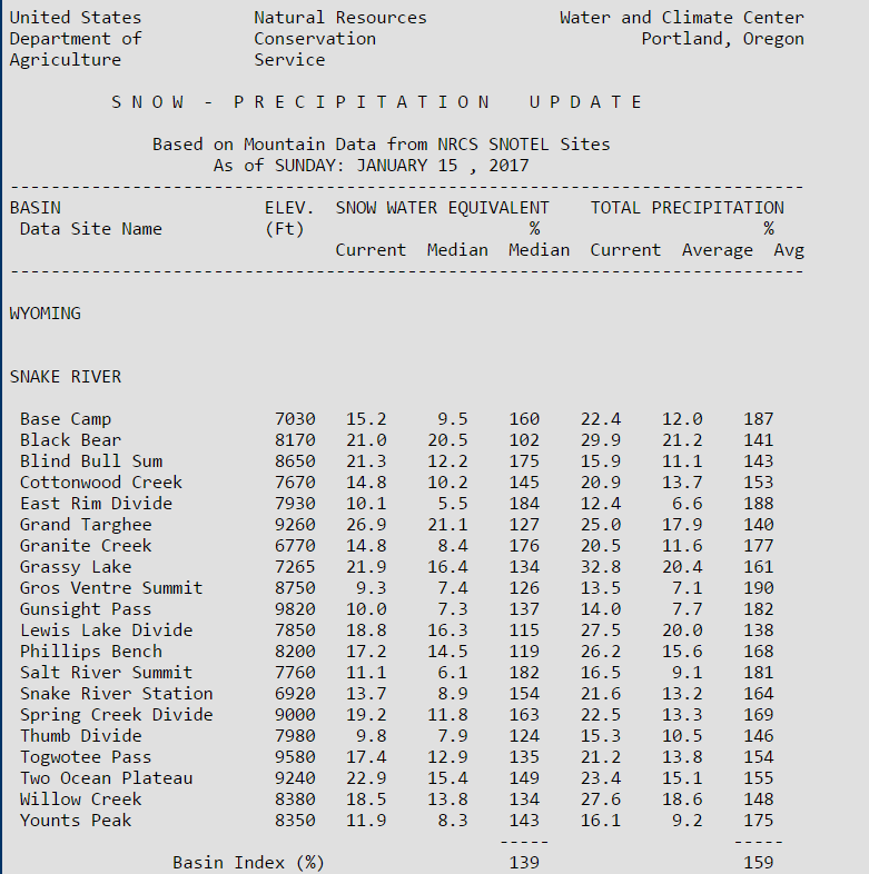
Of most interest to Star Valley is the status of the Snake River Basin.  The following is the reports of the SNOTEL sites that measure the snow that would flow into the Snake, Grey and Salt Rivers during this Springs runoff.

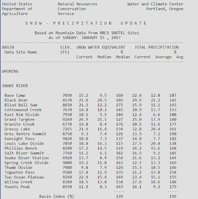
SNOTEL Reports as of January 15 2017

The total precipitation that has occurred since Oct 1 2016 is well above normal at all sites with the Grassy Lake SNOTEL  located near the southwest border of YNP leading the field with almost 33 inches, 161 percent of normal.

The Grand Targhee site(on the west Slopes of the Tetons at 9260 feet is measuring the greatest current snow water content of almost 28 inches, 127 percent of normal

Examining a few of the graphs of SNOTELS of most interest to Star Valley and the Salt and Grey River drainage  shows that given normal amounts of snow the remainder of the winter, they indicate a very favorable runoff this Spring.  


Thursday, January 12, 2017

Final snow totals are in from this past winter event


Public Information Statement
National Weather Service Riverton WY
0434 PM MST Thu Jan 12 2017

***Final snow totals are in from this past winter event***

Snow began in the west on Saturday night, January 7th, and ended
last night, January 11th.

Observations are collected from a variety of sources with varying
equipment and exposures.  Not all data listed are considered
official.  Total accumulations at SNOTEL locations are estimated.

Regardless, some locations received quite a lot of snow!

Location                              Snowfall
Lincoln County...
 Blind Bull Summit Snotel...         56 inches.
 Spring Creek Divide Snotel...       53 inches.
 Indian Creek Snotel...              53 inches.
 Willow Creek Snotel...              52 inches.
 Kelley Ranger Station Snotel...     47 inches.
 Blind Bull Summit...                47 inches.
 Salt River Summit Snotel...         44 inches.
 Commissary Ridge...                 42 inches.
 Hams Fork Snotel...                 40 inches.
 Cottonwood Creek Snotel...          36 inches.
 Star Valley Ranch...                29 inches.
 Box Y Ranch...                      28 inches.
 2 SE Thayne...                    27.9 inches.
 Alpine...                           25 inches.
 5 SSE Smoot...                      24 inches.
 Afton...                          15.2 inches.
 3 SE Bedford...                     15 inches.
 Kemmerer...                          9 inches.
 6 N Cokeville...                     7 inches.
 Afton...                             7 inches.
 Kemmerer...                          6 inches.
Big Horn County... Lovell... 19.1 inches. 2 SSW Lovell... 18.4 inches. Lovell... 16 inches. Lovell... 12 inches. Bone Springs Divide Snotel... 12 inches. Bald Mountain Snotel... 11 inches. Deaver... 10 inches. Shell Creek Snotel... 8 inches. Greybull... 2.4 inches. 9 ENE Greybull... 2.4 inches. 9 NNW Shell... 2 inches. Fremont County... South Pass Snotel... 54 inches. Deer Park Snotel... 53 inches. Hobbs Park Snotel... 30 inches. Burroughs Creek Snotel... 29 inches. Brooks Lake... 29 inches. Atlantic City... 24.7 inches. Townsend Creek Snotel... 17 inches. Little Warm Snotel... 16 inches. Castle Creek Snotel... 15 inches. Cold Springs Snotel... 14 inches. St. Lawrence Alt Snotel... 9 inches. Dubois... 4 inches. 9 SSE Lander... 0.3 inches. 6 SW Lander... 0.3 inches. 7 WNW Lander... 0.1 inches. Hot Springs County... Owl Creek Snotel... 4 inches. 9 NE Thermopolis... 0.5 inches. Johnson County... Bear Trap Meadow Snotel... 6 inches. Soldier Park Snotel... 5 inches. Little Goose Snotel... 5 inches. Cloud Peak Reservoir Snotel... 4 inches. Hansen Sawmill Snotel... 4 inches. Buffalo... 0.6 inches. Lincoln County... Blind Bull Summit Snotel... 56 inches. Spring Creek Divide Snotel... 53 inches. Indian Creek Snotel... 53 inches. Willow Creek Snotel... 52 inches. Kelley Ranger Station Snotel... 47 inches. Blind Bull Summit... 47 inches. Salt River Summit Snotel... 44 inches. Commissary Ridge... 42 inches. Hams Fork Snotel... 40 inches. Cottonwood Creek Snotel... 36 inches. Star Valley Ranch... 29 inches. Box Y Ranch... 28 inches. 2 SE Thayne... 27.9 inches. Alpine... 25 inches. 5 SSE Smoot... 24 inches. Star Valley Ranch... 19.2 inches. Afton... 15.2 inches. 3 SE Bedford... 15 inches. Kemmerer... 9 inches. 6 N Cokeville... 7 inches. Afton... 7 inches. Kemmerer... 6 inches. Natrona County... Casper Mountain Snotel... 2 inches. Grave Spring Snotel... 2 inches. 4 WSW Casper... 0.8 inches. Casper... 0.8 inches. 1 S Casper... 0.4 inches. 3 WSW Casper... 0.4 inches. Casper... 0.3 inches. Casper Airport... 0.3 inches. Park County... Wolverine Snotel... 32 inches. Blackwater Snotel... 30 inches. Younts Peak Snotel... 29 inches. Evening Star Snotel... 28 inches. Beartooth Lake Snotel... 26 inches. Pahaska... 22 inches. Kirwin Snotel... 18 inches. Wapiti... 13 inches. 1 ENE Wapiti... 12 inches. Cody... 10.2 inches. 2 NE Cody... 10 inches. Cody... 10 inches. 2 WSW Cody... 9 inches. Marquette Snotel... 9 inches. 5 ESE Cody... 9 inches. Cody... 9 inches. 26 SW Cody... 8.2 inches. 4 SE Cody... 7.5 inches. 4 ENE Powell... 7 inches. 3 NE Clark... 6.2 inches. Cody... 6 inches. 4 SW Powell... 6 inches. 5 ESE Cody... 4 inches. Powell... 4 inches. Powell... 3 inches. Timber Creek Snotel... 2 inches. 3 NE Sunshine... 0.4 inches. Sublette County... Triple Peak Snotel... 54 inches. Snider Basin Snotel... 41 inches. Kendall Ranger Station Snotel... 38 inches. Larsen Creek Snotel... 34 inches. Loomis Park Snotel... 34 inches. Bondurant... 32.6 inches. Big Sandy Opening Snotel... 30 inches. 14 NW Pinedale... 25.9 inches. East Rim Divide Snotel... 25 inches. Elkhart Park G.S. Snotel... 24 inches. New Fork Lake Snotel... 22 inches. Gunsite Pass Snotel... 22 inches. Daniel Fish Hatchery... 15 inches. 1 N Pinedale... 14 inches. Pinedale... 11.2 inches. Big Piney... 10 inches. Boulder Rearing Station... 7 inches. Sweetwater County... 7 SE Rock Springs... 7.8 inches. Wamsutter... 6 inches. Rock Springs... 4.8 inches. 5 N Farson... 4 inches. Rock Springs... 2.5 inches. Green River... 2.2 inches. Green River... 1.4 inches. Green River... 1.3 inches. Rock Springs... 1 inch. Buckboard Marina... 1 inch. 4 NNW Rock Springs... 0.6 inches. Teton County... Phillips Bench Snotel... 58 inches. Grassy Lake Snotel... 53 inches. Granite Creek Snotel... 49 inches. Jackson Hole - Raymer... 43.5 inches. Jackson Hole - Mid Mountain... 43 inches. Jackson Hole - Rendezvous Bowl... 43 inches. 3 SSW Wilson... 40 inches. 2 WSW Jackson... 40 inches. Togwotee Mountain Lodge... 39 inches. Base Camp Snotel... 35 inches. Snake River Stn Snotel... 33 inches. Togwotee Pass Snotel... 33 inches. Gros Ventre Summit Snotel... 30 inches. 5 NW Jackson... 30 inches. Snow King... 29 inches. Darwin Ranch... 28 inches. Grand Targhee - Chief Joseph... 28 inches. 2 NE Teton Village... 26.2 inches. Moose... 25.9 inches. Jackson Hole - Base... 22 inches. 2 SW Wilson... 20 inches. Jackson... 18.1 inches. Jackson Dam... 11.1 inches. 12 NE Jackson... 10 inches. 1 NNW Alta... 9 inches. Jackson... 8 inches. Washakie County... Powder River Pass Snotel... 5 inches. Middle Powder Snotel... 2 inches. 16 SSE Ten Sleep... 0.9 inches. Ten Sleep... 0.9 inches. 5 NNW Ten Sleep... 0.6 inches. 8 SW Worland... 0.5 inches. 27 S Ten Sleep... 0.1 inches. Yellowstone National Park... Lewis Lake Divide Snotel... 50 inches. Snake River Ranger Station... 44.8 inches. Two Ocean Plateau Snotel... 35 inches. Thumb Divide Snotel... 33 inches. Parker Peak Snotel... 23 inches. Sylvan Lake Snotel... 21 inches. Canyon Snotel... 18 inches. Sylvan Road Snotel... 18 inches. Yellowstone East Entrance... 17.5 inches. Old Faithful Ranger Station... 15.5 inches. Lamar Ranger Station... 14.5 inches. Tower Falls Ranger Station... 11.5 inches. Mammoth... 9 inches.

Wednesday, January 11, 2017

January 8-11 Wyoming Snowfall Map


Public Information Statement
National Weather Service Riverton WY
633 PM MST Wed Jan 11 2017

...Preliminary Storm Information Through Wednesday Evening...

The following are preliminary snowfall totals from Sunday,
January 8, until 6 PM Wednesday, January 11. Snow reports
will continue to come in through Thursday morning.

Observations are collected from a variety of sources with varying
equipment and exposures. Not all data listed are considered official.
Total accumulations at SNOTEL locations are estimated.

Location                              Snowfall
Lincoln County...
 Blind Bull Summit Snotel...         55 inches.
 Indian Creek Snotel...              52 inches.
 Willow Creek Snotel...              50 inches.
 Spring Creek Divide Snotel...       49 inches.
 Kelley Ranger Station Snotel...     45 inches.
 Salt River Summit Snotel...         43 inches.
 Blind Bull Summit...                43 inches.
 Commissary Ridge...                 39 inches.
 Hams Fork Snotel...                 39 inches.
 Cottonwood Creek Snotel...          34 inches.
 Alpine...                           25 inches.
 2 SE Thayne...                    24.4 inches.
 Star Valley Ranch...                23 inches.
 Box Y Ranch...                      23 inches.
 5 SSE Smoot...                      21 inches.
 Star Valley Ranch...              17.2 inches.
 3 SE Bedford...                     15 inches.
 Afton...                            14 inches.
 Kemmerer...                     7 to 9 inches.
 6 N Cokeville...                     7 inches.
Big Horn County... Lovell... 12 to 16 inches. Bone Springs Divide Snotel... 11 inches. Deaver... 10 inches. Bald Mountain Snotel... 9 inches. Shell Creek Snotel... 7 inches. 9 NNW Shell... 2 inches. Greybull... 1.2 inches. 9 ENE Greybull... 0.5 inches. Fremont County... Deer Park Snotel... 56 inches. South Pass Snotel... 56 inches. Hobbs Park Snotel... 30 inches. Burroughs Creek Snotel... 29 inches. Brooks Lake... 28 inches. Atlantic City... 24.7 inches. Townsend Creek Snotel... 17 inches. Little Warm Snotel... 16 inches. Castle Creek Snotel... 15 inches. Cold Springs Snotel... 11 inches. St. Lawrence Alt Snotel... 9 inches. Dubois... 3 inches. 9 SSE Lander... 0.3 inches. 6 SW Lander... 0.3 inches. Hot Springs County... Owl Creek Snotel... 4 inches. 9 NE Thermopolis... 0.2 inches. Johnson County... Bear Trap Meadow Snotel... 6 inches. Soldier Park Snotel... 4 inches. Hansen Sawmill Snotel... 4 inches. Cloud Peak Reservoir Snotel... 3 inches. Little Goose Snotel... 2 inches. Buffalo... 0.5 inches. Natrona County... Grave Spring Snotel... 2 inches. Casper Mountain Snotel... 2 inches. Casper... 0.5 inches. 4 WSW Casper... 0.4 inches. Casper Airport... 0.3 inches. 1 S Casper... 0.2 inches. Park County... Younts Peak Snotel... 27 inches. Wolverine Snotel... 27 inches. Beartooth Lake Snotel... 25 inches. Blackwater Snotel... 24 inches. Evening Star Snotel... 23 inches. Kirwin Snotel... 18 inches. Wapiti... 13 inches. Pahaska... 10 inches. 1 ENE Wapiti... 10 inches. 2 NE Cody... 10 inches. Cody... 6 to 10 inches. 2 WSW Cody... 6 inches. Marquette Snotel... 5 inches. 26 SW Cody... 4.2 inches. 5 ESE Cody... 4 inches. 3 NE Clark... 3.2 inches. 4 ENE Powell... 3 inches. Powell... 3 inches. 4 SW Powell... 3 inches. 4 SE Cody... 2.6 inches. Timber Creek Snotel... 1 inch. 3 NE Sunshine... 0.2 inches. Sublette County... Triple Peak Snotel... 53 inches. Kendall Ranger Station Snotel... 39 inches. Snider Basin Snotel... 38 inches. Loomis Park Snotel... 35 inches. Larsen Creek Snotel... 33 inches. Big Sandy Opening Snotel... 30 inches. Bondurant... 24.8 inches. East Rim Divide Snotel... 24 inches. 14 NW Pinedale... 23.4 inches. Gunsite Pass Snotel... 22 inches. Elkhart Park G.S. Snotel... 22 inches. New Fork Lake Snotel... 21 inches. Daniel Fish Hatchery... 15 inches. 1 N Pinedale... 14 inches. Pinedale... 10 inches. Big Piney... 10 inches. Boulder Rearing Station... 6 inches. Sweetwater County... 7 SE Rock Springs... 7.8 inches. 5 N Farson... 4 inches. Green River... 1.7 inches. Rock Springs... 1.5 inches. Buckboard Marina... 1 inch. Wamsutter... 1 inch. Teton County... Phillips Bench Snotel... 54 inches. Grassy Lake Snotel... 49 inches. Granite Creek Snotel... 48 inches. 2 WSW Jackson... 40 inches. Jackson Hole - Mid Mountain... 40 inches. Snow King... 39.8 inches. Jackson Hole - Raymer... 39.5 inches. Jackson Hole - Rendezvous Bowl... 39 inches. Togwotee Mountain Lodge... 37 inches. Snake River Stn Snotel... 31 inches. Base Camp Snotel... 31 inches. Togwotee Pass Snotel... 31 inches. 5 NW Jackson... 30 inches. Gros Ventre Summit Snotel... 29 inches. 3 SSW Wilson... 27 inches. 2 NE Teton Village... 26 inches. Grand Targhee - Chief Joseph... 25 inches. Moose... 24.8 inches. Jackson Hole - Base... 21 inches. 2 SW Wilson... 20 inches. Jackson... 17.6 inches. Darwin Ranch... 13.7 inches. 1 NNW Alta... 1 inch. Washakie County... Powder River Pass Snotel... 4 inches. Middle Powder Snotel... 2 inches. 16 SSE Ten Sleep... 0.5 inches. 5 NNW Ten Sleep... 0.1 inches. 27 S Ten Sleep... 0.1 inches. Yellowstone National Park... Lewis Lake Divide Snotel... 48 inches. Thumb Divide Snotel... 31 inches. Snake River Ranger Station... 25 inches. Two Ocean Plateau Snotel... 25 inches. Parker Peak Snotel... 23 inches. Sylvan Lake Snotel... 20 inches. Canyon Snotel... 18 inches. Sylvan Road Snotel... 16 inches. Old Faithful Ranger Station... 15.5 inches. Lamar Ranger Station... 12 inches. Yellowstone East Entrance... 11.5 inches. Tower Falls Ranger Station... 9.5 inches. Mammoth... 9 inches.


Winter Storm to Diminish This Evening Across Star Valley

URGENT - WINTER WEATHER MESSAGE
NATIONAL WEATHER SERVICE RIVERTON WY
149 PM MST WED JAN 11 2017

...LONG DURATION WINTER STORM CONTINUES TO IMPACT THE WEST
THROUGH THIS EVENING...

...WINTER STORM WARNING THROUGH THIS EVENING FOR THE CODY
FOOTHILLS AND THE NORTHERN BIG HORN BASIN...

...WINTER WEATHER ADVISORIES CONTINUE FOR PORTIONS OF CENTRAL AND
SOUTH CENTRAL WYOMING TODAY AND THIS EVENING...

.SEVERAL WEATHER SYSTEMS WILL IMPACT MUCH OF THE AREA THROUGH
TONIGHT BRINGING PERIODS OF MODERATE TO HEAVY SNOW AND WIND.


STAR VALLEY-
INCLUDING THE CITIES OF...AFTON...ALPINE...STAR VALLEY RANCH...
THAYNE
149 PM MST WED JAN 11 2017

...WINTER STORM WARNING REMAINS IN EFFECT UNTIL 11 PM MST THIS
EVENING...

* TIMING...LIGHT TO MODERATE SNOW WILL CONTINUE THIS AFTERNOON.
 LIGHT SNOW TONIGHT.

* SNOWFALL SO FAR...10 TO 26 INCHES WITH ANOTHER 1 TO 3 INCHES
  THROUGH THIS EVENING.

* TOTAL SNOW...1 TO 2 FEET WITH THE HEAVIER AMOUNTS TOWARDS THE
  NORTH END OF THE VALLEY. A FEW SPOTS COULD TOP 28 INCHES.

* WIND AND VISIBILITY...SOUTHWEST WIND INCREASING TO 15 TO 25
  MPH WITH GUSTS TO 35 MPH IN OPEN AREAS. VISIBILITIES UNDER ONE
  QUARTER MILE AT TIMES IN SNOW AND BLOWING SNOW.

* MAIN IMPACT...ROADS AND HIGHWAYS WILL BECOME SLICK AND SNOW
  PACKED WITH SHARPLY REDUCED VISIBILITY.

PRECAUTIONARY/PREPAREDNESS ACTIONS...

Western Wyoming Mega Snow Storm Update

Afternoon View  at Star Valley Ranch


Public Information Statement
National Weather Service Riverton WY
0107 PM MST Wed Jan 11 2017

A MAJOR LONG DURATION WINTER STORM IN WESTERN WYOMING HAS LED TO
SOME VERY IMPRESSIVE SNOWFALL TOTALS FROM SATURDAY NIGHT THROUGH
LATE THIS MORNING. IN CENTRAL WYOMING...SOME AREAS HAD SIGNIFICANT
SNOWFALL SINCE LAST NIGHT. HERE ARE SOME PRELIMINARY TOTALS THROUGH
LATE WEDNESDAY MORNING. SOME LOWER ELEVATION TOTALS DO NOT INCLUDE
SNOWFALL FROM LAST NIGHT AND THIS MORNING YET.

Location                              Snowfall
Lincoln County...
 Blind Bull Summit Snotel...         55 inches.
 Indian Creek Snotel...              52 inches.
 Willow Creek Snotel...              50 inches.
 Spring Creek Divide Snotel...       49 inches.
 Kelley Ranger Station Snotel...     45 inches.
 Blind Bull Summit...                43 inches.
 Salt River Summit Snotel...         43 inches.
 Hams Fork Snotel...                 39 inches.
 Commissary Ridge...                 39 inches.
 Cottonwood Creek Snotel...          34 inches.
 Alpine...                           25 inches.
 2 SE Thayne...                    24.4 inches.
 Star Valley Ranch...                23 inches.
 Box Y Ranch...                      23 inches.
 5 SSE Smoot...                      21 inches.
 Star Valley Ranch...              17.2 inches.
 1 N Alpine...                       10 inches.
 3 SE Bedford...                      9 inches.
 Kemmerer...                          9 inches.
 Afton...                             7 inches.
 6 N Cokeville...                     7 inches.
 Afton...                           6.4 inches.
 Kemmerer...                          6 inches.
Big Horn County... Lovell... 12 to 16 inches. Bone Springs Divide Snotel... 11 inches. Bald Mountain Snotel... 9 inches. Shell Creek Snotel... 7 inches. Lovell... 5.1 inches. 2 SSW Lovell... 3.4 inches. 9 ENE Greybull... 0.5 inches. Greybull... 0.1 inches. Fremont County... South Pass Snotel... 56 inches. Deer Park Snotel... 56 inches. Hobbs Park Snotel... 30 inches. Burroughs Creek Snotel... 29 inches. Brooks Lake... 28 inches. Townsend Creek Snotel... 17 inches. Little Warm Snotel... 16 inches. Castle Creek Snotel... 15 inches. Atlantic City... 13 inches. Cold Springs Snotel... 11 inches. St. Lawrence Alt Snotel... 9 inches. Dubois... 2 inches. 6 SW Lander... 0.3 inches. 9 SSE Lander... 0.3 inches. Hot Springs County... Owl Creek Snotel... 4 inches. Johnson County... Bear Trap Meadow Snotel... 6 inches. Soldier Park Snotel... 4 inches. Hansen Sawmill Snotel... 4 inches. Cloud Peak Reservoir Snotel... 3 inches. Little Goose Snotel... 2 inches. Buffalo... 0.2 inches. Natrona County... Casper Mountain Snotel... 2 inches. Grave Spring Snotel... 2 inches. Casper... 0.5 inches. Casper Airport... 0.3 inches. 4 WSW Casper... 0.1 inches. Park County... Wolverine Snotel... 27 inches. Younts Peak Snotel... 27 inches. Beartooth Lake Snotel... 25 inches. Blackwater Snotel... 24 inches. Evening Star Snotel... 23 inches. Kirwin Snotel... 18 inches. Wapiti... 10 inches. 2 NE Cody... 10 inches. 2 WSW Cody... 6 inches. Cody... 6 inches. Pahaska... 5 inches. Marquette Snotel... 5 inches. 26 SW Cody... 4.2 inches. 4 ENE Powell... 3 inches. Powell... 3 inches. Powell... 3 inches. 4 SW Powell... 3 inches. 4 SE Cody... 2.6 inches. Timber Creek Snotel... 1 inch. 3 NE Clark... 0.2 inches. Sublette County... Triple Peak Snotel... 53 inches. Kendall Ranger Station Snotel... 39 inches. Snider Basin Snotel... 38 inches. Loomis Park Snotel... 35 inches. Larsen Creek Snotel... 33 inches. Big Sandy Opening Snotel... 30 inches. Bondurant... 24.8 inches. East Rim Divide Snotel... 24 inches. 14 NW Pinedale... 23.4 inches. Gunsite Pass Snotel... 22 inches. Elkhart Park G.S. Snotel... 22 inches. New Fork Lake Snotel... 21 inches. 1 N Pinedale... 14 inches. Daniel Fish Hatchery... 13 inches. Big Piney... 10 inches. Pinedale... 10 inches. Boulder Rearing Station... 6 inches. Sweetwater County... 5 N Farson... 3 inches. 7 SE Rock Springs... 1.8 inches. Green River... 1.5 inches. Rock Springs... 1.5 inches. Green River... 1.3 inches. Rock Springs... 1.3 inches. Buckboard Marina... 1 inch. Rock Springs... 1 inch. Wamsutter... 1 inch. 4 NNW Rock Springs... 0.6 inches. Teton County... Phillips Bench Snotel... 54 inches. Grassy Lake Snotel... 49 inches. Granite Creek Snotel... 48 inches. 2 WSW Jackson... 40 inches. Jackson Hole - Mid Mountain... 39 inches. Jackson Hole - Rendezvous Bowl... 38 inches. Jackson Hole - Raymer... 37.5 inches. Togwotee Mountain Lodge... 37 inches. Togwotee Pass Snotel... 31 inches. Snake River Stn Snotel... 31 inches. Base Camp Snotel... 31 inches. 5 NW Jackson... 30 inches. Gros Ventre Summit Snotel... 29 inches. 3 SSW Wilson... 27 inches. Snow King... 27 inches. Grand Targhee - Chief Joseph... 26 inches. 1 ENE Teton Village... 26 inches. 2 SW Wilson... 20 inches. Jackson Hole - Base... 18 inches. Moose... 15.8 inches. 2 NE Teton Village... 15.5 inches. Darwin Ranch... 13.7 inches. Jackson Dam... 11.1 inches. 12 NE Jackson... 10.3 inches. Jackson... 8 inches. 1 NNW Alta... 1 inch. Washakie County... Powder River Pass Snotel... 4 inches. Middle Powder Snotel... 2 inches. 5 NNW Ten Sleep... 0.1 inches. Yellowstone National Park... Lewis Lake Divide Snotel... 48 inches. Thumb Divide Snotel... 31 inches. Snake River Ranger Station... 25 inches. Two Ocean Plateau Snotel... 25 inches. Parker Peak Snotel... 23 inches. Sylvan Lake Snotel... 20 inches. Canyon Snotel... 18 inches. Sylvan Road Snotel... 16 inches. Old Faithful Ranger Station... 15.5 inches. Yellowstone East Entrance... 11.5 inches. Lamar Ranger Station... 7 inches. Tower Falls Ranger Station... 5.5 inches.