Saturday, October 31, 2015

Snow is Coming

SPECIAL WEATHER STATEMENT
NATIONAL WEATHER SERVICE RIVERTON WY
331 PM MDT SAT OCT 31 2015

...SIGNIFICANT CHANGE TO WINTERLIKE CONDITIONS EXPECTED THROUGH
EARLY NEXT WEEK THROUGHOUT MUCH OF WESTERN HALF OF WYOMING...

WYZ013-023-025>027-011015-
JACKSON HOLE-STAR VALLEY-UPPER GREEN RIVER BASIN FOOTHILLS-
UPPER GREEN RIVER BASIN-SOUTH LINCOLN COUNTY-
INCLUDING THE CITIES OF...JACKSON...AFTON...ALPINE...
STAR VALLEY RANCH...THAYNE...PINEDALE...LA BARGE...BIG PINEY...
FARSON...KEMMERER...COKEVILLE
331 PM MDT SAT OCT 31 2015

DEEPENING PACIFIC TROUGH WILL BE APPROACHING THE ROCKY MOUNTAINS
THROUGH EARLY NEXT WEEK. THIS WEATHER SYSTEM HAS THE POTENTIAL TO
PRODUCE THE FIRST ACCUMULATING SNOWFALL OVER THE WEST MONDAY INTO
TUESDAY. SNOWFALL AMOUNTS OF 2 TO 5 INCHES ARE QUITE POSSIBLE WITH
LOCALLY HIGHER AMOUNTS. HUNTERS AND OTHER OUTDOOR INTERESTS
SHOULD PREPARE FOR A SIGNIFICANT CHANGE TO MORE WINTER LIKE
CONDITIONS DURING THE NEXT FEW DAYS. STAY TUNED FOR POSSIBLE
WINTER HIGHLIGHTS WITH THIS STORM SYSTEM.

Thursday, October 29, 2015

Snowiest Places

Jim Steenburg's( UofU)  blog on snowy areas that are the result of unique micro-climates is of interest.  Here in Star Valley the most favored micro-climates for heavy snow are more subtle, but one region that appears to have a maximum of snow is the Turnerville area where northwesterly flow is lifted  by the higher terrain on 3 sides. 


Top 10 Ski Area Microclimates

A microclimate refers to the unique meteorological conditions that occur at a given location or area.  Mountainous regions tend to produce a plethora of microclimates due to the strong influence that complex terrain has on meteorology.  Below are my top-10 U.S. ski-area microclimates, plus some honorable mentions, based on remarkable aspects of the snowfall characteristics compared to the surrounding area or region.

10. Wolf Creek Pass, CO

Colorado is not especially snowy, but Wolf Creek Pass is the exception to the rule.  At an altitude of 10,640 feet, the long-term observing site at Wolf Creek Pass has an average annual snowfall of 435 inches, highest in the state.  In addition, Wolf Creek Pass is well situated to be pounded in warm storms with southwesterly flow, resulting in snow with a higher average water content than found elsewhere in Colorado [10.3% (Judson and Doesken 2000)].

9. Gore Mountain, NY

Not all microclimates are good for skiing.  The problem at Gore is that it is too far east to get much lake effect and a bit to far northwest to receive as much nor'easter snow as the mountains of New England.  C'est la vie.

Source: Northeast Regional Climate Center
8. Mt. Bohemia, MI

Mt. Bohemia might be the most geographically isolated ski area in the contiguous United States.  It's on the Keweenaw Peninsula, about as far north as you can get on the UP of Michigan and nearly surrounded by Lake Superior.

Source: Google Maps
You want lake effect?  Mt. Bohemia is the place.  The resort claims an average snowfall of 273 inches and, although it's difficult to confirm this given a paucity of long-range observing sites in the area, it's clearly the snowiest ski area in the midwest.  And it's bloody cold too.  Deep powder, certain frostbite, what are you waiting for?

7. Jay Peak, VT

In 2008, Trevor Alcott and I wrote a paper for the Bulletin of the American Meteorological Society entitledSecrets of the Greatest Snow on Earth (I ultimately used the article as a springboard for my book of the same title).  When in review, one of the anonymous reviewers took great offense that we did not include Jay Peak in the analysis.  Fair enough.  Jay does especially well in northwesterly flow thanks to the orientation of the mountains of northern Vermont and a lack of substantial upstream terrain.  There are other northern Vermont ski areas benefit from these characteristics, but perhaps not to the extent of Jay Peak.  Plus the Jay Peak powder cult has threatened me enough that I no longer question the power of the Jay Peak cloud.

6. Alyeska, AK

Alyeska rises above the Turnagain Arm just east of Anchorage and has a base elevation of only 250 feet.  Due to the formidable nature of the Chugach Mountains and the maritime nature of the region, it probably has the largest snowfall gradient with altitude of any major resort in the United States, which results from both the increase in precipitation with altitude and the increase in the fraction of precipitation that falls as snow.  Resort statistics suggest a 208" mean snowfall at the base and a 512" mean snowfall at mid mountain (~1400 feet).  That staggering increase is characteristic of coastal Alaska, but where else do you find a major ski area cutting through it?

5. Snow Ridge, NY


In my view, Snow Ridge has the best quality natural snowfall in the northeast United States.  The area reports a very believable average snowfall of 230 inches, most of which is lake effect generated by Lake Ontario.  Even my snow-snobby students enjoyed a powder day there when we were working on the Tug Hill Plateau a couple of years ago.


4. Mammoth Mountain, CA

Mammoth Mountain gets an absolutely sick amount of snow for the eastern Sierra.  If you want to know why, look at the map below.  Note how big and broad the Sierra are to the north of Mammoth, and how big and broad the Sierra are to the south of Mammoth.  Then look at how the San Joaquin River cuts a path right to Mammoth Mountain's doorstep.  As a result, Sierra storms dump less load before hitting Mammoth, and Mammoth gets an unusual amount of snow for it's extreme eastern location.

Source: Google Maps
Meteorologists call the depletion of atmospheric water vapor by precipitation airmass transformation.  An interesting aspect of atmospheric water vapor is a very small fraction of it contains hydrogen isotopes that are relatively heavy (they have one proton and one neutron instead of just a proton).  Water vapor molecules that contain this heavier hydrogen isotope, known as deuterium, tend to condense more readily and rain out as an airmass pushes inland.  As a result, the snowpack in the eastern Sierra tends to be somewhat depleted of deuterium, except at one place.  Mammoth.

The map below is an oldie but a goodie and shows an analysis of deuterium in the Sierra snowpack.  Note the nose of higher values at Mammoth, illustrating that airmasses impinging on Mammoth Mountain have experienced less transformation and water vapor depletion that those that have traverse broader, higher topography to the north and south.

Ratio of deuterium to hydrogen (D/H) in Sierra snow expressed as a per mil
 departure from that found in standard ocean water (Friedman and Smith 1970).
3. Alta/Snowbird, UT

It's a bit self-serving to put Alta/Snowbird at #3 on this list, but I've yet to find an area in the contiguous United States with a better combination of quality and quantity than the upper Cottonwoods, and Little Cottonwood gets the nod here because it is a bit snowier than Big Cottonwood.

Source: Secrets of the Greatest Snow on Earth
All sorts of crazy ideas exist concerning why it snows so much in the upper Cottonwoods, but the most obvious is almost always overlooked.  The terrain around the Cottonwoods forms an island of high terrain that is exposed to flow from nearly every direction.  Alta and Snowbird are well known for snow in northwesterly flow, but they almost always get something even when the flow is from other directions.

Source: Secrets of the Greatest Snow on Earth
This tremendous diversity of storms leads to the large annual snowfall totals and contrasts with other high areas of the Wasatch (e.g., Mt. Timpangos), which lie along linear ridges and have a narrower storm spectrum (e.g., predominantly southwesterly flow).

2. Mt. Baker, WA

Snowiest ski area in the world.  World record 1,140 inches recorded in the 1998/99 season.  Admittedly, Mt. Baker ski area isn't even the snowiest location in the region it sits in due to its low altitude, but an average snowfall of nearly 650 inches puts it at #2 on this list.

1. Snoqualmie Pass, WA

I'm guessing you didn't see it coming, but Snoqualmie Pass has a truly unique and remarkable microclimate.

The problem in the Cascades isn't moisture, it's temperature.  West of Snoqualmie Pass and along much of the western slopes of the Cascades, skiing isn't viable at 3000 feet elevation, the base elevation of the ski areas in Snoqualmie Pass.  If you drive to Snoqualmie Pass from Seattle, the snow line is often above 3000 feet, but turn the corner and enter the pass and you find a huge snowpack.

There's one main reason for this: cold easterly flow.  For much of the winter, the Cascades separate relatively mild marine air to the west from colder continental air to the east.  This cold air frequently pushes into Snoqualmie Pass, resulting in locally lower snow levels than found to the west.

The climate in Snoqualmie Pass is very similar to that in Stampede Pass, which is just to the south and has had an official weather station for many years.  If you look at a wind rose for Stampede Pass in January, you see a predominance of easterly flow.

Source: Steenburgh et al. (1997)
And this has a significant impact on temperature.  If you compare the mean temperature at Stampede Pass to Paradise ranger station on Mt. Rainier, it's actually colder from December to February, despite the lower elevation.  This is because Stampede Pass (and Snoqualmie) are frequently under the influence of cold, easterly flow, whereas Paradise is west of the Cascade crest and cutoff from the cold easterlies.

Source: Steenburgh et al. (1997)
If you could plug the low-elevation corridors that issue from eastern Washington to Stampede and Snoqualmie Pass, the snow climate would change dramatically, a much greater fraction of wintertime precipitation would fall as rain instead of snow, and one of the busiest ski areas in the United States would probably cease to exist or be barely viable.

Although the cold easterly flow is a remarkable refrigerator, it's not going to be able to hold off the inevitable as the planet warms in the coming years.  The snow climate of Snoqualmie Pass is one of the most vulnerable to global warming because of its low elevation and frequent snowfalls at temperatures near (and above) 0ÂșC.

Honorable Mentions:

Grand Targhee, WY (prolific snowfall on the windward side of the Tetons)
Crystal Mountain, WA (Mt. Rainier cloud and precipitation shadow)
Stevens Pass, WA (cold easterly flow)
Mission Ridge, WA (strongly shadowed)
Mt. Shasta Ski Park, Mt. Bachelor, Mt. Hood ski areas (large volcano influences)
Keystone, CO (strongly shadowed)
Steamboat, CO (large, low-density, seasonal snowfall for Colorado)
Whiteface, NY (really cold, but hey, at least it doesn't snow very much too)
Snowshoe, WV (snowy spot for mid-Atlantic region)

Add your $0.02 by commenting.  I've focussed on ski areas here for brevity, but feel free to think broadly (i.e., backcountry) and globally.

Saturday, October 24, 2015

Hurricane Patricia Was One For the Record Books!

How and why Patricia stands above the four other most severe hurricanes in history


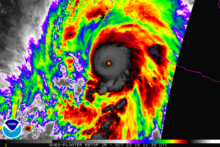
After attaining peak winds of 200 mph early this morning, Hurricane Patricia became the strongest storm ever recorded by the National Hurricane Center. It jumped to the top of a notorious list of the western hemisphere’s most vicious storms, dating back decades.
The record Patricia established spans not only hurricanes that impact western North America, but also those that impact eastern North America and the Caribbean.
The four storms which Patricia now looks down at are:
  • Hurricane Allen, 1980, peak winds of 190 mph (Caribbean and Gulf of Mexico)
  • Hurricane Wilma, 2005, peak winds of 185 mph (Caribbean and Gulf of Mexico)
  • Hurricane Linda, 1997, peak winds of 185 mph (Northeast Pacific)
  • Hurricane Gilbert, 1988, peak winds of 185 mph (Caribbean and Gulf of Mexico)
The unnamed hurricane of 1935 which struck the Florida Keys was also estimated to have peak winds of 185 mph.  However, estimates of hurricane peaks winds prior to the 1970s are very uncertain as there were no weather satellites watching these storms.
Let’s take a look back at each of these storms, and what defined them:
Hurricane Allen, 1980
Allen peaked in early August 1980 south of Haiti, where it killed over 200 people.  In the U.S., it is most remembered for its impact in south Texas, where – as a weaker storm – it moved ashore with 125 mph winds.  It produced up to 20 inches of rain and a storm surge up to 12 feet.
“Since this portion of Texas and Mexico were sparsely occupied, casualties were low, with only six deaths reported in Texas,” a NOAA Web site said.
Hurricane Wilma, 2005
Almost exactly a decade ago, Wilma exploded in intensity, deepening from a tropical storm to a Category 5 hurricane over the course of a day in the western Caribbean. It set the mark for the most rapid strengthening in the tropical Atlantic on record.
Wilma made landfall in Cozumel as Category 4 hurricane. NOAA reported at least 19 people were killed from Wilma’s rain and wind across the Caribbean and Mexico.
It then curled northeast to the southwest coast of the Florida peninsula where it made landfall near Naples on October 24 as a Category 3 storm. At least five deaths were directly attributed to the storm.
Hurricane Gilbert, 1988
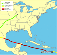
Gilbert experienced an extraordinary period of rapid intensification on Sept. 13 near the Yucatan Peninsula.
“Gilbert crossed the northeast coast of Mexico’s Yucatan peninsula on September 14th, becoming the first Category 5 hurricane in the Atlantic basin to strike land since Camille in 1969,” NOAA said.
After slamming the Yucatan Peninsula, Gilbert entered the Gulf of Mexico but spared the U.S. Gulf Coast, instead drifting into northeast Mexico south of the Texas border.
“Gilbert’s large size and impacts were felt over much of the Caribbean, Central America as well as portions of the United States,” NOAA said. “The death toll of 318 gives an idea of the scope of Gilbert’s impacts: Mexico 202, Jamaica 45, Haiti 30, Guatemala 12, Honduras 12, Dominican Republic 5, Venezuela 5, United States 3, Costa Rica 2, and Nicaragua 2.”
Hurricane Linda, 1997
Prior to Patricia, Linda held the record for the strongest hurricane to form in the Northeast Pacific Ocean. But with the exception of Socorro Island where it damaged some weather instruments, the storm remained over the ocean.
It attained its maximum intensity on Sept. 12, 1997 over the ocean.
Some of the storm’s moisture reached southern California, contributing to some rain. Waves generated by the storm reached 15 to 18 along the coast.
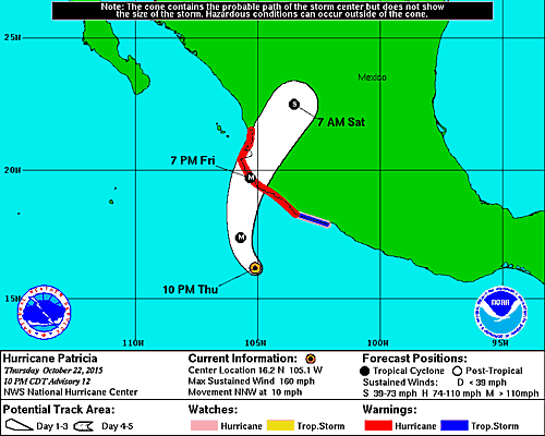
What sets Patricia apart from the others
Of all of the above monster storms, none of them struck land at peak intensity.  They either weakened or, in Linda’s case, stayed out to sea. Patricia is forecast to make landfall very near if not right at peak intensity.
The closest analog to Patricia in recent decades would probably be Super Typhoon Haiyan which hit a high populated portion of the Philippines when it was very close to its maximum intensity.  Its death toll was over 6,000 people. The area of Mexico that Patricia is forecast to impact is not as densely populated, which should reduce the amount of destruction and numbers of human casualties.
Going back further, the 1935 Florida Keys hurricane was also near maximum intensity at landfall, and is the most intense hurricane known to ever hit the U.S.   That storm, which produced a devastating 20 foot storm surge, killed 408 people, NOAA said.

Friday, October 23, 2015

Potentially catastrophic’ Patricia becomes strongest hurricane ever recorded

 
s


Early Friday, the behemoth Hurricane Patricia became the strongest hurricane ever measured by the National Hurricane Center. Patricia is forecast to make landfall on Mexico’s west central coast late Friday with destructive winds, torrents of rain, and a devastating storm surge.
The Category 5 storm’s maximum sustained winds strengthened to an astonishing 200 mph. “This makes Patricia the strongest hurricane on record in the National Hurricane Center’s area of responsibility (AOR) which includes the Atlantic and the eastern North Pacific basins,” NHC said. “The minimum central pressure estimated from the aircraft data, 880 mb, is the lowest ever for our AOR.”
The storm may even strengthen a little more. Officially, the NHC predicts Patricia will have peak winds of 205 mph when it strikes land, which would be the strongest ever recorded, anywhere in the world, including Super Typhoon Haiyan, which struck the Philippines with peak winds of 195 mph.
On Thursday, Hurricane Patricia explosively intensified from a tropical storm to a monstrous category five hurricane with 160 mph winds.
The rate of the storm’s intensification in day’s time is nothing short of historic. In the process, Patricia morphed from a loosely organized conglomeration of thunderstorms to the planet’s strongest and most wicked class of storm.
“Patricia is estimated to have intensified 85 kt [100 mph] in the past 24 hours,” the National Hurricane Center said in its 11 p.m. update Thursday. “This is a remarkable feat, with only Linda of 1997 intensifying at this rate in the satellite era.”
Centered 145 miles offshore the west coast of central of Mexico, Patricia threatens to come ashore somewhere between San Blas and Punta San Telmo, where a hurricane warning is in effect. This zone includes the resort town of Puerto Vallarta, with a population of just over 200,000 people.
“Confidence is increasing that Patricia will make landfall in the hurricane warning area as an extremely dangerous major hurricane Friday afternoon or evening,” stated the National Hurricane Center (NHC) in a special advisory issued at 2 p.m. EDT Thursday.
The storm has been able to achieve its historic intensity by developing over some of the warmest ocean temperatures in the Northern Hemisphere, over 86 degrees.

Tropical storms conditions have begun in the hurricane warning area.
The worst conditions are expected Friday afternoon and evening, when destructive winds are likely. Patricia is also forecast to produce 6-12 inches of rainfall, with isolated amounts to 20 inches, particularly in higher terrain.

Thursday, October 22, 2015

Potential Catastrophic Hurricane to hit Mexico Friday

Hurricane PATRICIA Public Advisory


Home   Public Adv   Fcst Adv   Discussion   Wind Probs   Graphics   Archive  

Possibly the strongest Hurricane ever recorded is heading for the coast of
southwest Mexico on Friday


BULLETIN
HURRICANE PATRICIA SPECIAL ADVISORY NUMBER  13
NWS NATIONAL HURRICANE CENTER MIAMI FL       

1230 AM CDT FRI OCT 23 2015
...CATEGORY 5 HURRICANE PATRICIA STRENGTHENS EVEN MORE...
...POTENTIALLY CATASTROPHIC LANDFALL IN SOUTHWESTERN MEXICO LATER
TODAY...


SUMMARY OF 1230 AM CDT...0530 UTC...INFORMATION
-----------------------------------------------
LOCATION...16.5N 105.3W
ABOUT 185 MI...295 KM SSW OF MANZANILLO MEXICO
ABOUT 270 MI...435 KM S OF CABO CORRIENTES MEXICO
MAXIMUM SUSTAINED WINDS...185 MPH...295 KM/H
PRESENT MOVEMENT...NNW OR 330 DEGREES AT 10 MPH...17 KM/H
MINIMUM CENTRAL PRESSURE...892 MB...26.34 INCHES


WATCHES AND WARNINGS
--------------------
CHANGES WITH THIS ADVISORY:

None

SUMMARY OF WATCHES AND WARNINGS IN EFFECT:

A Hurricane Warning is in effect for...
* San Blas to Punta San Telmo

A Hurricane Watch is in effect for...
* East of Punta San Telmo to Lazaro Cardenas

A Tropical Storm Warning is in effect for...
* East of Punta San Telmo to Lazaro Cardenas

A Hurricane Warning means that hurricane conditions are expected
somewhere within the warning area, in this case within about 24
hours. Preparations to protect life and property should be rushed to
completion.

A Tropical Storm Warning means that tropical storm conditions are
expected somewhere within the warning area.

A Hurricane Watch means that hurricane conditions are possible
within the watch area.

For storm information specific to your area, please monitor
products issued by your national meteorological service.


DISCUSSION AND 48-HOUR OUTLOOK
------------------------------
At 1230 AM CDT (0530 UTC), the eye of Hurricane Patricia was
located near latitude 16.5 North, longitude 105.3 West.  Patricia
is moving toward the north-northwest near 10 mph (17 km/h). A turn
toward the north is expected later this morning, followed by a turn
toward the north-northeast this afternoon.  On the forecast track,
the core of Patricia will make landfall in the hurricane warning
area this afternoon or evening.

Reports from an Air Force Reserve Unit Hurricane Hunter aircraft
indicate that the maximum sustained winds have increased to near 185
mph (295 km/h) with higher gusts.  Patricia is a category 5
hurricane on the Saffir-Simpson Hurricane Wind Scale.  Some
fluctuations in intensity are possible today, but Patricia is
expected to remain an extremely dangerous category 5 hurricane
through landfall.

Hurricane force winds extend outward up to 35 miles (55 km) from the
center and tropical storm force winds extend outward up to 175 miles
(280 km).

The minimum central pressure estimated from Hurricane Hunter
observations is 892 mb (26.34 inches).


HAZARDS AFFECTING LAND
----------------------
WIND:  Hurricane conditions are expected to first reach the
hurricane warning area this afternoon.  Tropical storm conditions
are expected to first reach the warning areas early today,
making outside preparations difficult or dangerous.  Preparations to
protect life and property should be rushed to completion. Hurricane
conditions are possible in the hurricane watch area late today.

RAINFALL:  Patricia is expected to produce total rainfall
accumulations of 6 to 12 inches, with isolated maximum amounts of 20
inches, over the Mexican states of Jalisco, Colima, Michoacan and
Guerrero through Saturday.  These rains could produce
life-threatening flash floods and mud slides.

STORM SURGE:  An extremely dangerous storm surge is expected to
produce significant coastal flooding near and to the right of where
the center makes landfall.  Near the coast, the surge will be
accompanied by large and destructive waves.

SURF:  Swells generated by Patricia are already affecting portions
of the southern coast of Mexico, and will spread northwestward
during the next day or so.  These swells are likely to cause
life-threatening surf and rip current conditions. Please consult
products from your local weather office.


NEXT ADVISORY
-------------
Next complete advisory at 400 AM CDT.

Thursday, October 15, 2015

El Nino Winter Ahead-Affect in Star Valley Indeterminate

Strong El Niño sets the stage for 2015-2016 winter weather

October 15, 2015 
Temperature.
Temperature - U.S. Winter Outlook: 2015-2016
(Credit: NOAA)
Forecasters at NOAA’s Climate Prediction Center issued the U.S. Winter Outlook today favoring cooler and wetter weather in Southern Tier states with above-average temperatures most likely in the West and across the Northern Tier. This year’s El Niño, among the strongest on record, is expected to influence weather and climate patterns this winter by impacting the position of the Pacific jet stream.
“A strong El Niño is in place and should exert a strong influence over our weather this winter,” said Mike Halpert, deputy director, NOAA’s Climate Prediction Center. “While temperature and precipitation impacts associated with El Niño are favored, El Niño is not the only player. Cold-air outbreaks and snow storms will likely occur at times this winter. However, the frequency, number and intensity of these events cannot be predicted on a seasonal timescale.”
Precipitation.
Precipitation - U.S. Winter Outlook: 2015-2016
(Credit: NOAA)
Other factors that often play a role in the winter weather include the Arctic Oscillation, which influences the number of arctic air masses that penetrate into the South and nor'easters on the East Coast, and the Madden-Julian Oscillation, which can impact the number of heavy rain storms in the Pacific Northwest.
The 2015 U.S. Winter Outlook (December through February):
Precipitation Outlook:
  • Wetter-than-average conditions most likely in the Southern Tier of the United States, from central and southern California, across Texas, to Florida, and up the East Coast to southern New England. Above-average precipitation is also favored in southeastern Alaska.  
  • Drier-than-average conditions most likely for Hawaii, central and western Alaska, parts of the Pacific Northwest and northern Rockies, and for areas near the Great Lakes and Ohio Valley.
Temperature Outlook:
  • Above-average temperatures are favored across much of the West and the northern half of the contiguous United States. Temperatures are also favored to be above-average in Alaska and much of Hawaii. Below-average temperatures are most likely in the southern Plains and Southeast.
Drought Outlook:
  • The U.S. Drought Outlook shows some improvement is likely in central and southern California by the end of January, but not drought removal. Additional statewide relief is possible during February and March. Drought removal is likely across large parts of the Southwest, while improvement or removal is also likely in the southern Plains. However, drought is likely to persist in the Pacific Northwest and northern Rockies, with drought development likely in Hawaii, parts of the northern Plains and in the northern Great Lakes region.
VIDEO: Winter Outlook for 2015-2016
Video: Winter Outlook 2015-2016. (Credit: NOAA)
While it is good news that drought improvement is predicted for California, one season of above-average rain and snow is unlikely to remove four years of drought,” said Halpert. “California would need close to twice its normal rainfall to get out of drought and that's unlikely.”
This seasonal outlook does not project where and when snowstorms may hit or provide total seasonal snowfall accumulations. Snow forecasts are dependent upon the strength and track of winter storms, which are generally not predictable more than a week in advance.

Water Year Oct 1 2014- Sep 30 2015 Western Wyoming Weather Summary

A comprehensive summary has been prepared by Riverton NWS of weather conditions for the water year ending September 30 2015.  This report can be accessed through by the following link:

Water Year Weather Summary

Sunday, October 4, 2015

South Carolina Rainfall October 4 2015

With the news of the torrential rains in  South Carolina, here is the post of the 3 day totals from the Charleston Weather Office.


PUBLIC INFORMATION STATEMENT
NATIONAL WEATHER SERVICE CHARLESTON SC
1140 AM EDT SUN OCT 4 2015

THE FOLLOWING ARE UNOFFICIAL STORM TOTAL RAINFALL REPORTS FROM
COCORAHS...ASOS...RAWS...AND SPOTTER REPORTS. RAINFALL TOTALS ARE
GENERALLY 3-DAY AMOUNTS BEGINNING AT 7 AM THURSDAY 1 OCTOBER 2015.

********************STORM TOTAL RAINFALL********************

LOCATION          STORM TOTAL     TIME/DATE   COMMENTS
                     RAINFALL           OF
                     /INCHES/   MEASUREMENT

SOUTH CAROLINA

...ALLENDALE COUNTY...
   2 SE ALLENDALE        2.61   600 AM 10/04  COCORAHS

...BEAUFORT COUNTY...
   4 N HILTON HEAD ISLA  5.77   700 AM 10/04  COCORAHS
   4 NNE BEAUFORT        5.47   839 AM 10/04  COCORAHS
   3 N BEAUFORT          5.30   700 AM 10/04  COCORAHS
   2 NNE BLUFFTON        2.15   700 AM 10/04  COCORAHS
   6 WNW BLUFFTON        2.04   700 AM 10/04  COCORAHS

...BERKELEY COUNTY...
   3 NNE HUGER          21.04   900 AM 10/04  USGS SITE
   1 NNW LIMERICK       19.71   900 AM 10/04  RAWS
   5 NNW HUGER          18.32   429 AM 10/04  STORM TOTAL
   4 E MONCKS CORNER    17.02   800 AM 10/04  COCORAHS
   1 SSW WANDO          16.90   800 AM 10/04  COCORAHS
   3 NW BONNEAU         16.71  1030 AM 10/04  COCORAHS
   3 NE MONCKS CORNER   16.17   700 AM 10/04  COCORAHS
   1 SSW DANIEL ISLAND  15.67   830 AM 10/04  COCORAHS
   1 SSE HANAHAN        15.30   900 AM 10/04  COCORAHS
   7 SW MONCKS CORNER   15.08   800 AM 10/04  COCORAHS
   1 N HANAHAN          14.39   945 AM 10/04  COCORAHS
   3 NE SUMMERVILLE     13.75   900 AM 10/04  COCORAHS
   4 NE SUMMERVILLE     13.36   700 AM 10/04  COCORAHS
   5 WNW GOOSE CREEK    12.96   700 AM 10/04  COCORAHS
   5 E GOOSE CREEK      12.79   900 AM 10/04  USGS SITE

...CHARLESTON COUNTY...
   6 NE MOUNT PLEASANT  24.23   700 AM 10/04  COCORAHS
   3 SSW SHADOWMOSS     22.47   900 AM 10/04  COCORAHS
   5 SSE CHARLESTON     20.37   800 AM 10/04  COCORAHS
   4 NNW KIAWAH ISLAND  18.25   700 AM 10/04  TRAINED SPOTTER
   2 S CHARLESTON       17.04   700 AM 10/04  COCORAHS
   2 NNW GARRIS LANDING 17.03   427 AM 10/04  STORM TOTAL
   1 NNE JAMES ISLAND C 17.00   929 AM 10/04  TRAINED SPOTTER
   3 ENE CHARLESTON     16.88   900 AM 10/04  COCORAHS
   1 E CHARLESTON       16.84   700 AM 10/04  COCORAHS
   CHARLESTON AIRPORT   16.61   900 AM 10/04  ASOS
   6 NW CHARLESTON      16.52   800 AM 10/04  COCORAHS
   NWS CHARLESTON SC    16.49   700 AM 10/04  COCORAHS
   3 NE CHARLESTON      16.46   700 AM 10/04  COCORAHS
   4 ESE NORTH CHARLEST 16.32   823 AM 10/04  COCORAHS
   2 ESE MOUNT PLEASANT 16.16   711 AM 10/04  COCORAHS
   2 NE JOHNS ISLAND    15.91   730 AM 10/04  COCORAHS
   2 NE KIAWAH ISLAND   15.69   800 AM 10/04  COCORAHS
   4 N NORTH CHARLESTON 15.33   900 AM 10/04  COCORAHS
   3 NNE CHARLESTON     15.14   745 AM 10/04  COCORAHS
   5 SW AWENDAW         15.02   723 AM 10/04  RAWS
   CHARLESTON           14.74   930 AM 10/04  OFFICIAL NWS OBS
   5 WNW CHARLESTON     14.74   600 AM 10/04  COCORAHS
   1 WSW MOUNT PLEASANT 14.37   800 AM 10/04  COCORAHS
   1 SW MOUNT PLEASANT  14.26   640 AM 10/04  COCORAHS
   CHARLESTON INTERNATI 14.22   756 AM 10/04  ASOS
   2 SSW WADMALAW ISLAN 14.02   800 AM 10/04  COCORAHS
   1 ESE MCCLELLANVILLE 13.88   800 AM 10/04  COCORAHS
   2 WSW CHARLESTON     13.88   700 AM 10/04  COCORAHS
   3 E MOUNT PLEASANT   13.78   700 AM 10/04  COCORAHS
   ESE MCCLELLANVILLE   13.78   630 AM 10/04  COCORAHS
   2 WNW RAVENEL        12.02   700 AM 10/04  COCORAHS
   2 W MEGGETT          11.77   745 AM 10/04  COCORAHS
   2 S MOUNT PLEASANT   11.70   800 AM 10/04  COCORAHS

...COLLETON COUNTY...
   3 ENE WALTERBORO      7.87   800 AM 10/04  COCORAHS
   2 ENE WALTERBORO      7.57   707 AM 10/04  RAWS
   3 NNW WALTERBORO      7.37   700 AM 10/04  COCORAHS
   3 SW LODGE            6.31   700 AM 10/04  COCORAHS
   8 NE YEMASSEE         5.29   700 AM 10/04  COCORAHS
   ESE SMOAKS            5.08   600 AM 10/04  COCORAHS

...DORCHESTER COUNTY...
   3 NW SUMMERVILLE     17.23   700 AM 10/04  COCORAHS
   1 SSW SUMMERVILLE    15.86   800 AM 10/04  COCORAHS
   2 N SUMMERVILLE      15.16   700 AM 10/04  COCORAHS
   2 W SUMMERVILLE      14.65   700 AM 10/04  COCORAHS
   7 S RIDGEVILLE       13.62   700 AM 10/04  COCORAHS
   SUMMERVILLE 4W       14.75   700 AM 10/04  CO-OP OBSERVER

...HAMPTON COUNTY...
   1 SW HAMPTON          3.19   700 AM 10/04  COCORAHS
   2 SSW BRUNSON         2.16   700 AM 10/04  COCORAHS

GEORGIA

...CHATHAM COUNTY...
   11 WSW SAVANNAH       2.40   900 AM 10/04  COCORAHS

...SCREVEN COUNTY...
   MILLHAVEN             2.22   700 AM 10/04  USGS
   1 SSE NEWINGTON       2.07   700 AM 10/04  COCORAHS

&&

Saturday, October 3, 2015

Rainfall Reports Western Wyoming as of Noon Saturday October 3 2015

...RAINFALL REPORTS PAST 48 HOURS STARTING AT NOON THURSDAY...OCTOBER 1ST AND
ENDING AT NOON SATURDAY..OCTOBER 3RD...

LOCATION                     AMOUNT    TIME/DATE       PROVIDER
...LINCOLN COUNTY...
THAYNE 1.5 SE                0.46 IN   0700 AM 10/03   COCORAHS
STAR VALLEY RANCH            0.45 IN   0700 AM 10/03   COCORAHS
SMITHS FORK NEAR BORDER      0.37 IN   1230 PM 10/03   HADS
SMOOT 4.9 SSE                0.31 IN   0700 AM 10/03   COCORAHS
THAYNE                       0.26 IN   1244 PM 10/03   CWOP
4 NE THAYNE                  0.24 IN   1245 PM 10/03   CWOP
3 NW ETNA                    0.23 IN   1245 PM 10/03   CWOP
15 NE COKEVILLE              0.23 IN   1200 PM 10/03   RAWS
1 S BEDFORD                  0.22 IN   1234 PM 10/03   CWOP
AFTON                        0.21 IN   1245 PM 10/03   CWOP
5 SSE LA BARGE               0.19 IN   1200 PM 10/03   HADS
...BIG HORN COUNTY... LOVELL 0.42 IN 1242 PM 10/03 CWOP LOVELL 2.4 SSW 0.33 IN 0700 AM 10/03 COCORAHS SHELL 9.5 NNW 0.20 IN 0700 AM 10/03 COCORAHS LOVELL 0.4 S 0.19 IN 0700 AM 10/03 COCORAHS ...FREMONT COUNTY... DUBOIS 2.83 IN 1239 PM 10/03 CWOP 10 N DUBOIS 0.95 IN 1157 AM 10/03 RAWS 19 WSW DUBOIS 0.86 IN 1210 PM 10/03 RAWS 9 WSW BURRIS 0.80 IN 1150 AM 10/03 RAWS 6 NW DUBOIS 0.70 IN 1115 AM 10/03 HADS DUBOIS 9.7 WNW 0.64 IN 0700 AM 10/03 COCORAHS LANDER AIRPORT 0.61 IN 1200 PM 10/03 ASOS LANDER 5.7 SW 0.52 IN 0730 AM 10/03 COCORAHS LANDER 0.52 IN 0700 AM 10/03 COCORAHS CROWHEART 0.49 IN 1245 PM 10/03 CWOP 10 W FORT WASHAKIE 0.49 IN 1201 PM 10/03 RAWS LANDER 7.3 WNW 0.49 IN 0700 AM 10/03 COCORAHS LANDER 0.9 W 0.48 IN 0900 AM 10/03 COCORAHS LANDER 1.3 SW 0.47 IN 0900 AM 10/03 COCORAHS 1 NNW LANDER 0.38 IN 0700 AM 10/03 COCORAHS RIVERTON NWS 0.38 IN 1200 PM 10/03 NWS RIVERTON 0.34 IN 0700 AM 10/03 COOP 1 W RIVERTON 0.33 IN 0700 AM 10/03 COCORAHS RIVERTON AIRPORT 0.31 IN 1200 PM 10/03 ASOS 10 W DUBOIS 0.26 IN 1233 PM 10/03 CWOP ...HOT SPRINGS COUNTY... THERMOPOLIS 0.9 SW 0.54 IN 0800 AM 10/03 COCORAHS THERMOPOLIS 9 NE 0.45 IN 0700 AM 10/03 COOP ...JOHNSON COUNTY... BUFFALO 4.1 SSW 0.72 IN 0700 AM 10/03 COCORAHS BUFFALO AIRPORT 0.64 IN 1200 PM 10/03 ASOS 2 NW MAYOWORTH 0.62 IN 1244 PM 10/03 CWOP 10 SW KAYCEE 0.61 IN 1200 PM 10/03 HADS KAYCEE 17 NNW 0.36 IN 0700 AM 10/03 COCORAHS BUFFALO 11.9 SSE 0.21 IN 0700 AM 10/03 COCORAHS BUFFALO 7.3 NE 0.17 IN 0700 AM 10/03 COCORAHS ...NATRONA COUNTY... MIDWEST 0.43 IN 1244 PM 10/03 CWOP POWDER RIVER 0.16 IN 0800 AM 10/03 COOP CASPER 1.6 S 0.15 IN 0700 AM 10/03 COCORAHS CASPER 1.3 SW 0.15 IN 0800 AM 10/03 COCORAHS ...PARK COUNTY... 14 S SYLVAN PASS 1.13 IN 1208 PM 10/03 RAWS 10 WNW CODY 1.05 IN 1140 AM 10/03 RAWS CODY 25.7 SW 1.02 IN 0700 AM 10/03 COCORAHS POWELL 0.99 IN 1245 PM 10/03 CWOP PAHASKA 0.97 IN 0700 AM 10/03 COOP CRANDALL 0.90 IN 1212 PM 10/03 RAWS EAST ENTRANCE YELLOWSTONE NP 0.89 IN 0700 AM 10/03 COOP 3 E PAHASKA 0.84 IN 1157 AM 10/03 RAWS CODY 7.3 SW 0.80 IN 0700 AM 10/03 COCORAHS CODY - COOP 0.79 IN 0737 AM 10/03 COOP BUFFALO BILL RESERVOIR 0.74 IN 1145 AM 10/03 HADS LAKE YELLOWSTONE 0.69 IN 1200 PM 10/03 ASOS CODY 0.67 IN 0700 AM 10/03 COCORAHS 20 SW CODY 0.66 IN 1241 PM 10/03 CWOP POWELL 4.2 SW 0.65 IN 0700 AM 10/03 COCORAHS 1 W CLARK 0.62 IN 1236 PM 10/03 CWOP 3 NE CLARK 0.59 IN 0800 AM 10/03 COOP 5 WNW CLARK 0.58 IN 1241 PM 10/03 CWOP NE ENTRANCE YELLOWSTONE 0.55 IN 1145 AM 10/03 HADS CODY 5.0 ESE 0.46 IN 0700 AM 10/03 COCORAHS POWELL 3.9 ENE 0.45 IN 0700 AM 10/03 COCORAHS 1 SW CANYON 0.38 IN 1149 AM 10/03 RAWS 3 W POWELL 0.21 IN 1239 PM 10/03 CWOP MAMMOTH AT YELLOWSTONE NP - 0.18 IN 0800 AM 10/03 COOP 2 N FRANNIE 0.11 IN 1245 PM 10/03 CWOP 15 WSW MAMMOTH 0.10 IN 1149 AM 10/03 RAWS ...SUBLETTE COUNTY... 7 NE PINEDALE 0.82 IN 1226 PM 10/03 RAWS DANIEL FISH HATCHERY - COOP 0.60 IN 0800 AM 10/03 COOP PINEDALE 13.8 NW 0.51 IN 0700 AM 10/03 COCORAHS BONDURANT 0.40 IN 1200 PM 10/03 HADS 9 E BIG PINEY 0.40 IN 1200 PM 10/03 HADS 2 NW BONDURANT 0.40 IN 1151 AM 10/03 RAWS PORTABLE RAWS 0.32 IN 1225 PM 10/03 RAWS DANIEL 15.6 WNW 0.26 IN 0700 AM 10/03 COCORAHS BIG PINEY AIRPORT 0.19 IN 1200 PM 10/03 ASOS 21 W BIG PINEY 0.10 IN 1209 PM 10/03 RAWS ...SWEETWATER COUNTY... GREEN RIVER 0.22 IN 0700 AM 10/03 COOP FLAMING GORGE - BUCKBOARD MA 0.21 IN 0745 AM 10/03 UCOOP FARSON - COOP 0.21 IN 0700 AM 10/03 COOP ROCK SPRINGS 4.4 NNW 0.17 IN 0700 AM 10/03 COCORAHS ...TETON COUNTY... WILSON 2.6 SSW 1.25 IN 0800 AM 10/03 COCORAHS MOOSE - COOP 1.21 IN 0800 AM 10/03 COOP 2 NE WILSON 1.03 IN 1241 PM 10/03 CWOP 4 N MOOSE 1.03 IN 1158 AM 10/03 RAWS TETON VILLAGE 1.6 NE 1.02 IN 0700 AM 10/03 COCORAHS JACKSON 3.5 SSW 0.97 IN 0800 AM 10/03 COCORAHS JACKSON 0.81 IN 1245 PM 10/03 CWOP LAKE VILLAGE 0.81 IN 1200 PM 10/03 HADS 4 SW JACKSON 0.75 IN 1243 PM 10/03 CWOP 3 SSW JACKSON 0.75 IN 1242 PM 10/03 CWOP MORAN 0.72 IN 0800 AM 10/03 COOP JACKSON 12.2 NE 0.70 IN 0700 AM 10/03 COCORAHS ALTA 0.68 IN 1145 AM 10/03 HADS 7 E MORAN JCT 0.66 IN 1152 AM 10/03 RAWS SNAKE RIVER AT JACKSON LAKE 0.66 IN 0945 AM 10/03 HADS HOBACK JUNCTION 0.49 IN 1243 PM 10/03 CWOP PORTABLE RAWS 0.45 IN 1151 AM 10/03 RAWS 17 N ALTA 0.40 IN 1203 PM 10/03 RAWS OLD FAITHFUL 0.37 IN 0800 AM 10/03 COOP EXTREME SW YELLOWSTONE 0.24 IN 1149 AM 10/03 RAWS BECHLER RANGER STATION - COO 0.23 IN 0800 AM 10/03 COOP PORTABLE RAWS 0.17 IN 1235 PM 10/03 RAWS ...WASHAKIE COUNTY... 15 SSW BIG TRAILS 0.34 IN 1140 AM 10/03 RAWS WORLAND AIRPORT 0.31 IN 1200 PM 10/03 ASOS WILD HORSE 0.24 IN 1148 AM 10/03 RAWS WORLAND 2.8 NE 0.14 IN 0700 AM 10/03 COCORAHS WORLAND 0.12 IN 0700 AM 10/03 COOP OBSERVATIONS ARE COLLECTED FROM A VARIETY OF SOURCES WITH VARYING EQUIPMENT AND EXPOSURE. NOT ALL DATA LISTED ARE CONSIDERED OFFICIAL.