Thursday, July 28, 2016

Average Warmest Day Of the Year

During the summer months, many areas in the United States approach their highest temperatures for the year. To give you a better idea of the warmest time of year for your area, NCEI has created these “Warmest Day of the Year” maps for the contiguous United StatesAlaska, and  Hawaii. The maps are derived from the 1981–2010 U.S. Climate Normals, NCEI’s 30-year averages of climatological variables including the average high temperature for every day. From these values scientists can identify which day of the year, on average, has the highest maximum temperature, referred to here as the “warmest day.”

Here in Star Valley the last week of July is typically the warmest and that seems to be holding up in 2016 so far.

Although the amount of solar radiation reaching Earth peaks at the summer solstice on June 21 in the Northern Hemisphere, temperatures for most of the United States tend to keep increasing into July. The temperature increase after the solstice occurs because the rate of heat input from the sun during the day continues to be greater than the cooling at night for several weeks, until temperatures start to descend in late July and early August.

But, this isn’t the case everywhere! The “Warmest Day of the Year” maps show just how variable the climate of the United States can be. For instance, the June values in New Mexico and Arizona reflect the North American Monsoon, a period of increased rainfall affecting the U.S. Southwest. Because these areas tend to be cloudier and wetter from July through September, the temperature is highest on average in June. Similarly, the persistence of the marine layer along the Pacific Coast leads to cool temperatures in early summer with the warmest days on average later in the season.
Temperature Normals are important indicators that are used in forecasting and monitoring by many U.S. economic sectors. Knowing the probability of high temperatures can help energy companies prepare for rising electricity demand and help farmers monitor heat-sensitive crops. They are also useful planning tools for the healthcare, construction, and tourism industries. You may want to check the Normals before planning your next event or vacation.

Checking on both Alaska and Hawaii,


Sunday, July 24, 2016

Roller Coaster Daily Temperature Ranges

Western Wyoming is currently under a classic regime of clear skies, low humidity and calm nighttime winds that produce  dramatic diurnal temperatures ranges.  Following is a view of Star Valley at sunset Sunday with another cool night ahead.

Bedford Cam Sunday evening.

Double L weather station along the Salt River is typical of large temperature ranges in many Star Valley areas the past several days.


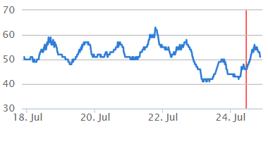
While each afternoon has seen temperatures rise into the 80's the nights cool off dramatically.  Just this Sunday morning the low was 33, with likely some light frost in sheltered area, while this afternoon once again it warmed to 83, some 51 degrees above the morning minimum

Even more dramatic is the 7 day graph at Bondurant.

The last couple of mornings have seen lows below freezing, followed by 80's by late afternoon  . Just this Sunday after a frigid  morning low of 25, the temperature rose 58 degrees to an afternoon high of 83.  

However in the mountains, the nighttime inversion does not develop to the extent as in the nearby valleys.  Such an example is on Deadman Peak, elevation above 10,000 feet.

Diurnal changes  in the mountains are considerably less than the nearby valleys.  In this case only 20 degrees or so.

In the Tetons, at Teton Saddle, variations from night to day are even less at the 11,600 feet elevation.

At that elevation while the days are cooler than nearby valley areas,  the nights are mild with only 10-15 degree ranges.


Friday, July 22, 2016

Star Valley Ranch Downburst

For the 2nd time in a week downburst  winds rolled across Star Valley this Friday afternoon. The only weather station detecting strong winds was again Star Valley Ranch where peak gusts to 46 mph was measured at 3:16 PM. Additionally hail to the size of mothballs was reported just south of Star Valley Ranch on Alford Way.

Following is the wind gusts and temperature graph for the Star Valley Ranch weather station for today, Friday July 22nd.

Blue peak wind gust-red temperaature Friday July 22 2016
Thanks to the location of the web cam located south of Bedford which monitors the Star Valley Ranch area, the series of relatively small storms could be observed  crossing the area.  The first one produced the observed 46mph gust at Star Valley Ranch. Another gust above 35mph accompanied the next thundershower.


The frame of the cam about the time of the 46mph gusts follows.

Bedford 2S web cam image about 3:15 PM 7/22/16

Wednesday, July 20, 2016

Lava Mountain Fire

The Lava Mountain Fire has been burning since July 10th when it was initiated by a lightning strike. The fire is located west northwest of Dubois WY just south of US26.  Above is a video from the Lava Mountain Cam this afternoon and evening pointed at the fire.

This is the latest incident report  of the fire.

Lava Mountain Fire

NEWS RELEASE

Evacuation Update and Closures
Residences from MacKenzie Highland Ranch to the Lava Creek Ranch are currently in evacuation stage "GO". This means they are leaving immediately. All other residences west of Big Diamond Ranch are in.more
INCIDENT UPDATED 1:13 HRS. AGO

Approximate Location

43.642 latitude, -109.968 longitude 
Map data ©2016 Google
Map
Satellite
10 km 

Incident Overview

Lava Mountain Fire, Infrared Flight Map, July 20th, 6AM
Image options: [ Enlarge ] [ Full Size ]
Lava Mountain Fire is burning northwest of Dubois on the Wind River Ranger District of the Shoshone National Forest and is active in thick timber. The fire was caused by lighting and smoke was first reported on July 10th. Firefighters walked the area and made several flights. However, for the first few days, crews were unable to locate the fire due to its lack of size and visible smoke. On July 16th the fire grew to around 250 acres due to increased temperatures and wind. At that time, additional resources were ordered and a Type 2 Incident Management Team was deployed to Dubois.
Because of the significant amounts of dead and down trees and snags it is unsafe to engage the fire except for those areas where the Forest has conducted numerous fuel reduction work. As a result of this work, the intensity of the fire is greatly reduced which then allows for firefighters to safely engage the fire.
For these reasons, suppression efforts are focused on the east side of the fire along Forest Service Road 540 and the private structures in the valley. In addition to structure protection on private property, suppression efforts are actively taking place along the Forest Service Road 540. If the conditions are appropriate, firefighters will conduct a burnout designed to remove the fuels between FSR 540 and the main fire. If done, this burnout will help prevent the fire from running across the road and towards the nearby structures. While spot fires may still occur, this back-burn will help provide a more defensible position for crews to protect the structures from.
Air support is being also used to assist in suppression efforts. In dead and down timber, water and fire retardant temporarily reduce the fire’s intensity in the immediate area. To be most effective, aerial resources need to work in conjunction with firefighters on the ground so they can take advantage of the opportunity. Air operations are not being used in areas that are currently unsafe for firefighters because without that team work, the attempts to curb fire growth would likely fail. We are also sharing these resources with other incidents. So, based on threats and safety concerns, the number of helicopters and planes actively working the Lava Mountain Fire will likely change throughout the day.


Basic Information

Current as of7/20/2016, 9:00:52 PM
Incident TypeWildfire
CauseLightning
Date of OriginMonday July 11th, 2016 approx. 11:00 PM
Location20 miles northwest of Dubois, WY
Incident CommanderRick Connell

Current Situation

Total Personnel334
Size875 Acres
Fuels Involved
The fire is burning in dense standing dead timber that spreads slowly except for when weather allows for continuous heating of heavy fuels and/ or exposure to wind. When weather aligns for growth, trees are torching and producing short range spotting leading to the majority of the growth.
Significant Events
All resources available at Lava Mountain are currently working the fire. Day crews will continue suppression efforts until around 10:30 pm at which time night crews will take over.

Outlook

Planned Actions
Crews will continue working with landowners to protect property through point zone protection, evaluation, and preparation of structures.
Projected Incident Activity
Fire spread will be reduced overnight but will continue with continuous heavy fuels. Point zone protection and patrol will occur in areas near structures overnight. Thursday is expected to have more favorable weather with cooler temperatures, higher humidity, and less wind which may slow fire growth. Continued fuel preparation and structure protection measures will continue and use of aviation and ground resources to reduce fire spread as needed for point zone protection.
Remarks
Evacuations are occurring for affected residences along Hwy 26 between Mackenzie Highland Ranch and Lava Creek Ranch. Highway 26 remains open but Forest roads 540, 662, and a portion of 532, along with Motorized Trail 10 are closed.

Current Weather

Weather Concerns
Tomorrow, winds west to southwest at 12 mph and gusting to 22 mph will contribute to fire spread although temperatures will be slightly lower with a high of 79 degrees and the relative humidity rising to 18 percent.

Monday, July 18, 2016

Cliff Creek Fire-Evacuations Ordered Monday Afternoon

Updated Monday Afternoon

UPDATE—3 p.m., Monday, July 18: Teton County Emergency Management has ordered an immediate evacuation for Granite Creek due to the Cliff Creek Fire. People at Granite Hot Springs and Campground, Safari Club International, and the Jack Pine Summer Homes should evacuate immediately. “The Cliff Creek Fire has crossed Shoal Creek and is spotting on the ridge above Granite Creek,” the alert stated.  “The Incident Management Team believes there is an imminent threat to life and property in Granite Creek.”
The Red Cross has set up an evacuation center in Teton County at Colter Elementary School, 1830 High School Rd., in Jackson.

A lightning strike ignited the Cliff Creek Fire north of Bondurant WY Sunday afternoon.

The Bondurant web cam captured not only the high based thunderstorm  that likely produced the culprit lightning strike but also within an hour caught the very rapid increase in smoke produced by the fire.  The cam is located near Bondurant looking north. Note the passage of the thunderstorm between 2-3pm and within an hour the smoke from the fire.


Here is the most recent report on the Cliff Creek Fire as of Monday morning

Cliff Creek Fire Still Burning North of Bondurant, WY

Incident: Cliff Creek Fire Wildfire
Released: 29 min. ago
The Cliff Creek fire is still burning on the Bridger-Teton National Forest near Bondurant, Wyoming. An area closure is expected to be in place today for much of the Forest north of Bondurant. It might include the Shoal Creek and Granite Creek drainages. Clark's Draw is expected to remain open.

Through the evening last night there was a few trees that were torching, or completely going up in flames, but for the most part, the burning activity slowed down with the cooler temperatures. Fire engines were in the Bondurant area providing structure protection through the evening.

Three helicopters will be supporting the firefighters today. 9 engines are on scene and working on the fire including resources from the Bridger-Teton National Forest, Grand Teton National Park and Sublette County Fire.

The fire danger remains at "High" for the Bridger-Teton. An updated acreage for the Cliff Creek fire will be available when it is safe for the aircraft to fly around the perimeter of the fire for a new map.

Visit www.tetonfires.com or https://www.facebook.com/BridgerTetonNF/ for additional information.

Friday, July 15, 2016

High Based Convection Produces evening downburst winds Star Valley Ranch

Strong daytime heating evidence by the temperature rising from an early morning low of 38 at Etna Elementary to a high of 90, produced very high based cumulonimbus which tracked across Star Valley Ranch during the late afternoon/evening. While only sprinkles actually reached the ground, the evaporation from the precipitation falling from the high based clouds, did produce down burst winds. The strongest reported gust was 45 mph at Star Valley Ranch at 6:13 pm.  The following cam video taken from Bedford looking north across Star Valley Ranch clearly shows the cumulonimbus clouds and the evaporating precipitation.


Tuesday, July 12, 2016

Cold July Morning-Tuesday July 12 2016


Following table was compiled by Riverton WFO


Mid Summer Freeze!


Temperatures dropped to near or in some areas well below freezing in western Wyoming this Tuesday morning.  The coldest observed was a frigid 23 in Bondurant.  In Star Valley the coldest was reported in the Afton area.


Minimum Temperatures July 12 2016


Regional Temperature and Precipitation Table
National Weather Service Riverton WY
614 AM MDT TUE JUL 12 2016


      Western and Central Wyoming Airport Locations

 Note - Values represent yesterdays highs, lows over the last 12
        hours, and precipitation over the last 24 hours ending at
        6 am mdt

.BR RIW 0712 M DH05/TAIRZX/TAIRZP/PPDRZZ
:
:                               Max   Min
:ID    Station           Elev   Temp  Temp  Pcpn
:
AFO  : Afton             6215:   59 /  32 /    M
46U  : Alpine            5635:   63 /  41 /    M
BPI  : Big Piney         6975:   65 /  29 / 0.00
BYG  : Buffalo           4970:    M /   M /    M
CPR  : Casper            5320:   74 /  45 /    T
COD  : Cody              5100:    M /   M /    M
U68  : Cowley            4090:    M /   M /    M
DUB  : Dubois            7260:   55 /  36 /    M
EVW  : Evanston          7165:   66 /  39 / 0.00
FBR  : Fort Bridger      7030:   70 /  42 /    M
GCC  : Gillette          4330:   73 /  46 / 0.00
GEY  : Greybull          3935:   74 /  49 / 0.00
W43  : Hulett            4265:    M /   M /    M
JAC  : Jackson           6445:   57 /  30 /    M
EMM  : Kemmerer          7285:   64 /  32 /    M
P60  : Lake Yellowstone  7835:   48 /  29 / 0.01
LND  : Lander            5585:   73 /  46 / 0.00
PNA  : Pinedale          7085:   57 /  30 /    M
POY  : Powell            5050:   68 /  46 /    M
RIW  : Riverton          5525:   72 /  50 / 0.00
RKS  : Rock Springs      6760:   69 /  43 / 0.00
SHR  : Sheridan          3965:   75 /  40 / 0.00
HSG  : Thermopolis       4900:   75 /  35 /    M
WRL  : Worland           4245:   75 /  42 / 0.00
.END


An Interesting short video this morning from the Snow King Cam
as fog dissipated in the valley below over Jackson


Monday, July 11, 2016

Strong Mid Summer Cold Front Sweeps Across Star Valley

An unusually strong mid summer cold front was accompanied by thunderstorms, including considerable hail up to an inch in diameter and gusty winds along with much cooler temperatures.

Hailstones  up to an inch in diameter were measured at Star Valley Ranch and just south of Etna around 1pm.  Below is a picture of a large limb downed along the Bedford Bench shortly after 5pm.


The web cam located south of Bedford, dramatically captured the very turbulent skies looking north toward Star Valley Ranch during the day on Sunday.


Thursday, July 7, 2016

June was Record Warm for Contiguous U.S.


While it was the warmest June on Record according to the National Center for Environmental Information, I don't believe you will hear any complaints from those residing in Star Valley Wyoming.

Kids playing in City Gardens in St. Louis MO on June  22 2016 when it was 100 F.
Summer is off to a sizzling start.
The average June temperature for the Lower 48 states was 71.8 degrees F, making it the warmest June on record, according to scientists from NOAA’s National Centers for Environmental Information. Above-average temperatures spanned the nation from coast to coast, and 17 states across the West, Great Plains and parts of the Southeast experienced temperatures much above average. June precipitation for the contiguous U.S. averaged 2.46 inches, 0.47 inch below average, ranking as the 14th driest on record.  
Through the midpoint of the year (January–June), the contiguous U.S. average temperature was 50.8 degrees F, 3.2 degrees F above average and the third warmest on record. Every state was warmer than average for the year to date, and Alaska continued to shatter heat records.
US Significant Events Map June 2016
US Significant Events Map June 2016 (NOAA NCEI)
Notable climate events include:
  • Alaska: Record warmth spanned Alaska from January through June. The statewide average temperature for this period was 30.4 degrees F, 9.0 degrees F above average, and 2.5 degrees F warmer than the previous record in 1981.
  • West Virginia: During June 23-24, more than 10 inches of rain in parts of West Virginia causing record flooding that resulted in at least 23 fatalities and the loss of over 1,500 homes.
  • Tropical Storm: Tropical Storm Colin made landfall along Florida’s Gulf Coast on June 6 with sustained winds of 50 mph. Colin brought heavy rainfall to the Southeast and caused four fatalities.
  • U.S. Drought: By the end of June, 16.2 percent of the contiguous U.S. was in drought, up about 3.5 percent compared to the end of May. Drought remained entrenched in parts of California and the far west, and expanded to other parts of the nation.  
  • Billion Dollar DisastersSo far in 2016, the U.S. has experienced eight billion-dollar weather and climate-related disasters, resulting in the loss of 30 lives and causing at least $13.1 billion in damages (note: losses from the late-June West Virginia floods are still being assessed and are not included in this tally).

Wednesday, July 6, 2016

Mid-Summer Cool Down/Snow in the Mountains!

The Computer Models have been indicating for the past couple of days that an unusually strong mid July storm system will be taking  aim at Wyoming this coming weekend. While Saturday should be warm and dry, with increasing winds, a strong cold front will cross the state of Wyoming Sunday. Strong winds and falling temperatures on Sunday will accompany the cold front with showers and thundershowers. Snow levels will drop by Sunday evening with the potential for several inches in the highest elevations of Yellowstone NP and the Tetons.

The system that will be providing this abrupt change can be seen on this mornings water vapor image approaching the Aleutian Islands

9am Wednesday July 6 2016

 A series of forecast 500 mb charts tracks the system as it heads toward Wyoming by Sunday.

500 mb 6am July 6 2016

500 mb 6am Saturday July 9 2016

500 mb 6pm Sunday July 10 2016


Surface 6 PM Sunday  July 10 2016
 
The surface indicates the cold front crossing western Wyoming by Sunday evening with a deepening surface low over northeast Wyoming.

While confidence is now good that unseasonably cool air will affect Star Valley and western Wyoming the amount of actual precipitation is still uncertain.  The models indicate that the heaviest will be in Montana, but at least some is possible across Star Valley.

24 hour forecast precipitation ending 6 pm Monday July 11 2016


Of particular interest is the real possibility of a mid July snow event in the higher elevations. The air mass will be cold enough for snow flakes as low as 7000 ft MSL Sunday night,  several inches could occur in the higher elevations of the Tetons and YNP.

24 hour Snowfall forecast 6pm Monday July 11 2016


Of most concern will be the potential of freezing temperatures in the colder Star Valley locations, most likely on Tuesday morning.  The model indicates that potential in the valleys of much of  Western Wyoming and even Colorado Rocky high mountain valleys.


6am Temperatures Tue July 12 2016