Sunday, April 29, 2012

Etna Elementary Weather Station

The Davis Weather Station located on top of Etna Elementary started observing on October 12,2010 and has the longest uninterrupted record of the three new stations in the Lower Star Valley.  The data collected from the Etna station includes temperature, humidity, precipitation,  wind direction and speed  along with the barometric pressure.

The purpose of this post is to review the conditions that have occurred since the station  was established, with emphasis on the most recent 12 months.

The first graph will show the maximum and minimum temperatures for the first 12 months of the station beginning October 2010


This next graph displays the maximum and minimum temperatures for the most recent 12 month period  through the end of April 2012


Relative humidity, which is a function of both the temperature and the moisture(dew point), remains  consistently higher throughout the colder months.

 The weather station also measures both the indoor temperature and humidity at the location of the  station console.  In the case of Etna  this is in the administration office.  As would be expected, the temperatures year around remain at a  comfortable level.  However, in the winter months the actual water vapor in the air is quite low, even though the outside relative humidity is typically high.

This results in very low indoor humidity in the cold months. Comparing inside/outside relative humidity dramatically illustrates this.


It is very interesting to look at a cold week beginning January 9, 2012.


The red line represents the outside temperature with the orange representing the inside temperature. Note the indoor  relative humidity represented by the yellow line on the graph.  While the indoor temperature remains  around 80F the entire week, the indoor relative humidity rises/falls in concert with the outside temperature.  For the entire week the indoor humidity rises no higher than 10 percent, while on the coldest day it drops to as low as nearly 0 percent!  This provides an environment drier than the desert in the heat of the summer!

This is likely typical of any heated building or home in the winter months in Star Valley. One can conclude that it would be of importance to provide an artificial source of moisture via humidifiers to improve the  indoor environment.

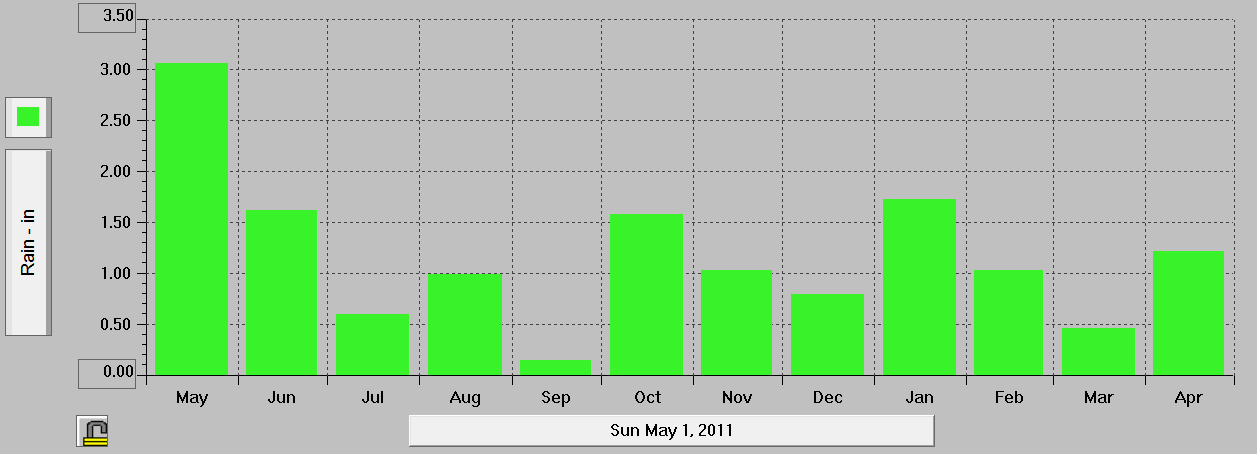
 The Etna Rain Gauge has a heater installed, melting the snow that is caught.  The problem during the Winter since the gauge is on the roof of the school the wind that typically accompanies the snow reduces the amount that is actually caught and measured.  Thus the most reliable measurements would occur in the warmer months when precipitation is liquid. The bar graph below shows the monthly precipitation caught:


The weather station also computes the wind run:


Wind run is a meteorological term used to categorize or determine the total distance (or amount) of the traveled wind over a period of time. The readings are collected using an anemometer.
Wind run can help to determine the rate of evaporation of moisture over a particular area.

From the data Spring seems to be the windiest period with the least this past December.  The winter low in wind run is reasonable given the amount of time the valley is under an inversion, when winds typically are very light.

The weather station also keeps track of the highest daily wind gust

In the past 12 months there were two times when the wind gusted above 50 mph. During the cold of December when inversions dominated, winds typically were under 10 mph.

The software associated with the weather station also provides annual summary charts.

These are the charts for 2011, the first full year of the Etna School Station


Thursday, April 26, 2012

Return to More Typical Late April Weather

A cold front will cross Western Wyoming this Thursday evening bringing an end to the unusual string of warm days for Star Valley.  The strong cold upper trough moving eastward with the front is responsible for the change.
500 mb Analysis with radar at 5pm Wednesday 4/26/2012

Along with the 500mb analysis is the corresponding radar image showing the more widespread precipitation along with cold front.  While scattered  showers and thundershowers have occurred across Star Valley Thursday afternoon, when the front passes more general showers will occur with a rapidly lowering snow level.  Very gusty winds have been reported with the Star Valley Ranch observation hitting 56 mph at 1:45pm with a passing thundershower.

By morning the snow level will have lowered to the valley floor but any significant accumulation should be confined to the higher elevations with several inches possible above 7500 feet.

The Riverton WFO has provided a short video discussion  covering the expected weather for Western Wyoming through the first of next week.  It can be viewed here.

http://www.crh.noaa.gov/riw/?n=weatherbriefing

Monday, April 23, 2012

A Day for the Weather Record Book

It is hard to believe that there is still a week left in April, as the weather is behaving more like June or July.  Not only are temperatures running near/above record level,  high based afternoon thunderstorms are developing in response to the heating.

Here is the Monday evening 500mb chart showing the huge upper ridge over the west and deep, cold trough across the eastern states.

To provide some perspective as to the how warm the temperatures are, the record high  for the month of April at the Bedford climate station going back to 1975 is 75 degrees.  While at the Afton COOP station the highest for the month of April going back to 1957 is 78 degrees.

Following are maximums recorded across Star Valley on Monday

Etna Elementary         82

Thayne Elementary     82

Star Valley Ranch        79
   
Alpine                          81     

 Smoot                         75

Auburn                         80


Afton                            77

The statement issued by the WFO at Pocatello Monday evening  is of interest:
 
RECORD EVENT REPORT 
 NATIONAL WEATHER SERVICE POCATELLO ID
 715 PM MDT MON APR 23 2012
 
 ...RECORD HIGH TEMPERATURES SET FOR THE MONTH OF APRIL...
 
  IDAHO FALLS AND POCATELLO BOTH ESTABLISHED HIGH TEMPERATURE RECORDS 
 FOR THE MONTH OF APRIL TODAY.
 
  IDAHO FALLS RECORDED 86 DEGREES TODAY WHICH IS THE ALL TIME APRIL 
 HIGH BREAKING THE PREVIOUS RECORD OF 85 SET ON THE 29TH OF APRIL IN 
 1992. 
 
  86 DEGREES IN POCATELLO TIED THREE PREVIOUS RECORDS OF 86 SET ON 
 THE 21ST IN 1994...29TH IN 1992...AND 25TH IN 1946. 
 
 
There is at least one more day of similar weather as the upper high pressure 
remains in place through Tuesday.  However changes will begin Wednesday with not 
only cooler temperatures but an increase chance of thunderstorms. 
 
By the weekend a trough of low pressure will reside over Wyoming returning Star Valley
to more typical late April conditions. 
 
500 mb forecast Mid Day Sunday  April 29 2012
 

Thursday, April 19, 2012

Thayne Elementary Weather Station

A Davis Weather Station was installed  at Thayne Elementary School in September 2010 and has been transmitting data since 3pm  September 22, 2010.  There has been only one interruption of data from the station which occurred from September 28,2011 until October 25, 2011.  On August 15, 2011 the sensors for both soil temperature and moisture were added to the station.

Here are some interesting graphs of some of the data thus far from the station.  Though not able to grab more than a year at a time, this first image is the daily maximum and minimum temperature for the first 12 months:


Thayne Elementary max and min temps from September 2010 to August 2011
and the most recent twelve months:

Thayne Elementary max and min temps from May 2011 to April 2012

For the short history of the station, the highest observed temperature was 94F on August 26, 2011.  The coldest occurred on February 2, 2011 when -30F was observed.  The coldest this past winter also occurred in 2011 when  -15F was hit on December 23rd.

The winter of 2010-2011 saw the temperature dip below zero on 28 days  This past winter there were 40 days  below zero.  December 2011 was particularly cold when 20 days dipped below zero.

In 2011, the first full summer of observations, there were only 6 days when the temperature exceeded 90F.

The highest wind gust thus far observed was 54 mph at 6pm, June 29,2011.

It is interesting to look at the data which has been collected with the soil moisture and temperature sensors since they were installed last August.

The first temperature sensor is located just below the surface on the school  grounds with the  2nd sensor buried at a depth of one foot and the third at 2 feet.

When looking at the sensor located just below the surface, it is surprising to see the large range of temperatures on particularly sunny days.

Near surface Thayne Elementary  temperature
There were a couple days around 100F last September and even above 80F already this spring.

However the 1 foot and 2 foot sensors tell a much different story with both dropping to freezing early in January and remaining there until the last week in March.

Thayne Soil Temperature at a depth of one foot


Thayne Soil Temperature at a depth of two feet.
The moisture sensor thus far indicates fairly high soil moisture content

Thayne 1 foot soil moisture content in centibars
The current reading of 10 centibars is a very moist soil.  It will be interesting to see how this sensor responds during summer  It can be observed any time on line at
 http://www.weatherlink.com/user/thayne/index.php?view=summary&headers=1

For additional information (as to what this measurement suggests) the following  is helpful:

General rule of thumb for interpretation:
Soil moisture is nearing a critically dry level when soil tension (indicated by the centibar meter reading) reaches a level that corresponds to more than 50 percent depletion of the plant available water at a specific soil depth.  The critical soil  tension level that corresponds with 50 percent depletion levels will vary depending upon soil type because of different soil porosity characteristics..   For example, a soil  tension reading of 35 centibars may indicate that a very sandy soil will approach 50 percent depletion of plant available soil moisture but for a loam/silt loam soil 50 percent depletion may  not be approached until tension readings approach 110 to 130 centibars.

Tuesday, April 17, 2012

April 14 2012 Tornado Outbreak

A significant Tornado Outbreak occurred this past Saturday, April 14th across the Central Plains.  April is prime time for Tornadoes in this part of the country, so this event was not unusual.  Probably what made this Outbreak so memorable was the advance warning that was provided by the Storm Prediction Center in Norman OK.

The SPC forecasts the potential for Severe Thunderstorms and Tornadoes out to 8 days in advance.  However it is very unusual to actually issue a risk of Severe Thunderstorms beyond about 3-4 days due to the limitations in model accuracy.  In the case of 4/14/12 the confidence of the forecasters at the SPC was sufficient to provide a heads up to the Central Plains a week in advance.  Following are the forecast made at the SPC for the Tornado Outbreak from a week out up to Saturday April 14th.


Not only was the area highlighted well in advance, but by Thursday a Moderate Risk was issued for the Central Plains and an unprecedented High Risk went out in the initial Day 2 Outlook on Friday morning.  This very accurate forecast is a testament to the quality of work done by the SPC, but also to the continuing improvement in the accuracy of the computer models that the forecasters are dependent on.

While the reported storm events are still preliminary, it is of interest to see how organized they were.  Supercells which in many cases lasted for several hours were responsible for the majority of particularly the tornado reports.  This link to the storm reports on the 14th  clearly shows this :

http://www.spc.noaa.gov/climo/gm.php?rpt=120414_rpts

Due to the presence of literally hundreds of chasers and their video equipment, many of the tornadoes already have footage that can be seen on Youtube.com.

There is an excellent site on the SPC home page that archives the pertinent meteorological parameters of  April 14th,  This can be viewed at http://www.spc.noaa.gov/exper/archive/event.php?date=20120414.

For anyone with an interest in the meteorology of the day,  this site provides one stop shopping.

Wednesday, April 11, 2012

Exceptionally Warm Period Coming to an End

Wednesday will be the last of a string of exceptionally warm early April days.  Since Sunday, each afternoon has seen temperatures likely near  record levels. With the air mass quite dry the nights still have cooled off with around 50 degree ranges from minimum to maximum each day.  Here are the readings from across Star Valley from Sunday through Tuesday.


                            Sunday 4/8       Monday 4/9      Tuesday 4/10

Thayne ES              65/22                  71/20               74/22
 Etna    ES              67/24                  72/21                77/21
 Star Valley Ranch   61/28                  66/29                72/31
 Osmond ES            M/M                  69/M                74/24
 Afton                     63/23                  68/21                72/25
 Auburn                   66/21                 70/19                73/22
 Alpine                     65/27                 71/25                76/28
 Salt River Summit    59/32                 63/37                67/42

To provide some perspective as to how warm these last few days were, at the official Climatological Station 3SE Bedford, going back to 1975, the record for the month of April is 75F which occurred on the 25th in 1977.  Both Etna ES and Alpine exceeded this temperature on Tuesday.

The warm days were also experienced in the higher elevations.  At the Willow Creek SNOTEL site in the Salt River Range around 8500 feet daytime temperatures have been near 60.

 
Accordingly the snow pack is rapidly decreasing:

As has been well forecast by the models, a change to a more typical mid April weather pattern is underway as this mornings 500 mb analysis shows the first in a series of upper troughs is moving inland toward  Wyoming.

A much colder upper low noted this morning in the Gulf Of Alaska will drop southeastward into the desert southwest by Saturday:

500 mb forecast Saturday morning 4/14/12

While the primary jet and energy with this upper low will track south of Star Valley, this is a cold and potent system.  The first trough moving across Star Valley tonight will bring showers and even a possible thundershower with the snow level lowering to the valley floor by morning.   Then periods of precipitation can be expected into the weekend primarily in the form of snow. Heavier amounts are expected to the south of  Star Valley, but given the forecast strength of the low moving inland by Saturday, a few inches accumulations can not be ruled.

Saturday, April 7, 2012

Snow Pack Runoff Still Ahead

The large upper trough which passed across Star Valley on Friday has moved well to the east as of Saturday evening.


500 mb Analysis Saturday Evening 4/7/12

 The deep upper low off the west coast pumps up the upper ridge moving into the Western States and brings with  it three days of exemplary weather to much of the Cowboy state and surrounding environs.  Afternoon temperatures under a strong Springtime sun should reach well into the 60s through the first part of the coming work week.

This time of year there is always a question as to when the runoff from the mountain snow melt will commence.  Looking at the conditions in the Salt River Range, particularly at the Willow Creek SNOTEL site as of Saturday evening suggests that the snow pack melting is about on a normal schedule:

While slightly below normal the SWE(snow water equivalent) has only dropped less than 10 percent from the peak at the end of March, even though there has been several warm days.


While the actual snow depth has diminished close to 30 percent since early March, the snow density has steadily increased(compacted). 

Examining the river gauge on the Salt near Etna for the past week show a gradual decrease from a high point on  4/1.  The projected stages of little change for the coming week


 seem reasonable as the trough off the west coast moves into the interior west by weeks end.

500 mb forecast Mid day Friday 4/13/12

The amount of duration of the precipitation that will accompany the trough after Wednesday is uncertain at this time as much of the energy appears to remain to the south of Star Valley.  However it will be substantially colder  with snow levels once again to the valley floor. 

The longer range forecast from the Climate Prediction Center from Friday until the first of the following week suggest a wet, relatively mild period.


This is a forecast period that needs to be look at with suspicion as models, particularly in the Spring, when systems begin to slow down, diminish in skill

Wednesday, April 4, 2012

Star Valley Ranch Snow Gauge Video-Winters 2011 vs 2012

Now that the snow is just about gone is a good time to compare the snow gauge videos made at Star Valley Ranch.

The winter 2010-2011 Winter video  of the snow gauge is here

 http://www.youtube.com/watch?v=pvym_ENf6L8

This winters video was made with a somewhat less quality of a camera, since the StarDot used last year is the one currently in the Star Valley Public Works  building with a view across the valley.

This years video begins the middle of December and continues daily until April 4th.

http://www.youtube.com/watch?v=SMOZ2_5JBUo

Both years the maximum snow depth was very similar, however the obvious difference is when the snow finally melts.  While nearly gone as of April 4th this year,  it was over a month later, around the 10th of May that snow finally disappeared.