Sunday, September 30, 2012

September Wrap-up and A Look Ahead

September continued the theme of Summer 2012 in Star Valley, Very warm and very dry,.

Here are the stats for the local stations in Star Valley including the dates of the Max/Min temps and the date of the peak wind in MPH.

                                 Max    Min     Rain   Peak Wind   # Days 32 F or lower
Thayne ES                 85-9  24-13   .17     38-16            15
Etna ES                      86-9  26-13    .23     32-2               7
Star Valley Ranch      82-8 35-18    .25     48-2                0
Etna 2NE                    86-9 26-13    .44     28-4                7
Alpine                         86-9 28-13    .33     33-12              2
Smoot                         80-9 27-13    .39     34-12


The most striking data is the number of mornings with freezing temperatures.  Thayne ES had half the days of the month with freezing or below. While just about 4 miles northeast at Star Valley Ranch the first freezing temperature has yet to be observed.  Thayne ES recorded the first below freezing morning on August 25 with a 31F.  The official growing season has been 5 weeks longer at Star Valley Ranch vs the colder valley locations represented by the Thayne ES observations.

While the Thayne ES observations are taken on the roof of the school, there is also the soil sensors for the school.  The first of three sensors is located just below the surface and the following graph displays the large diurnal ranges that occur near the surface.

 
Soil temperature at Thayne ES just below the surface-Sept 2012

On a couple days notably the 14th, diurnal ranges were in excess of 75F. Morning minimum of 23F was followed by an afternoon maximum to nearly 100F. This illustrates the environment for near ground crops vs most locations where the regular temperature observations are considerably higher, above the ground..

It was a much different story with sensor #2 which is buried about 2 feet below the surface.  It can be seen from the following graphic that a steady decrease in temperature occurs much of the month of September

2 foot soil temperature Thayne ES -Sept 2012


This steady downward temperature trend reflects  the overall decreasing solar radiation as we go into the Fall and a lower sun angle.  The solar radiation graphic at Thayne ES for the month shows this trend.

Solar radiation at Thayne ES Sept-2012


While there were a few mostly cloudy days in the third week of the month, overall sunny skies predominated.  The slow but steady decrease in radiation can be noted on the graph.

Now a brief  look ahead to the coming week.  It now seems assured that the first Fall like cold front will sweep across the Star Valley region by mid week.  While it appears that the main energy and precipitation will remain from the continental divide eastward,  daytime temperatures will drop from near 70F  Monday and Tuesday afternoon to not much above 50F the remainder of the week.  Snow will likely occur from areas of Yellowstone NP eastward, with much of the affect in Star Valley limited to strong gusty winds and dropping temperatures.  By Thursday morning a hard freeze is likely across Star Valley including those areas along the mountain slopes in the trees that have thus far been spared.  The remainder of the week will remain seasonably cool with freezing temperatures each night.

Following are the 500MB charts for Sunday evening and the forecast 500MB chart for Wednesday evening, Oct 3rd.

Sunday evening Sept 30-2012 500 mb analysis

500 MB forecast Wednesday evening Oct 3rd 2012

The surface forecast for Wednesday shows the Canadian high pressure moving southward east of the continental divide with the much colder air mass.
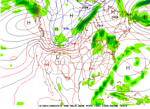
Surface pressure forecast for Wednesday evening Oct 3 2012

The only hope for precipitation with the system this far west will be stronger deepening into our area which now the computer models agree will likely not happen.

Friday, September 28, 2012

Another Great Week of Early Fall Weather

It has been a delightful month of September and several more beautiful days are expected.  Here is a sampling of the month as has been experienced in Star Valley looking at the  Etna ES weather station records.


Etna ES high and low temperatures for September 2012

The weekly weather briefing from Riverton WFO follows

http://www.crh.noaa.gov/riw/?n=weatherbriefing

As indicated from the briefing there is a threat of a change in the warm, dry weather pattern by the end of this coming week.  It is still too soon to express with any degree of confidence if this will be the first fall like weather this year.  The reliability of the computer models this far in advance is limited.

Friday, September 21, 2012

Smoke and Rain?

Forest fire smoke is covering a large area of the Northwestern U.S. including normally clean and beautiful Star Valley.  In case you may have forgotten what a clear days looks like here are a couple pictures from the Star Valley Ranch cam looking west to the Caribou Mountains.  The first photo was taken Friday morning September 21 and below that is the same view as of July 4th this year.

The source of our smoke here in Star Valley fortunately is some distance away, but with such a hot, dry summer which officially ends this weekend, fires continue to burn across much of the interior Northwest.  The following figure illustrates not only where those fires are, but what area is affected by the large smoke plume that the fires are generating.


Many of the fires are located over the central Idaho mountains and the eastern Cascades of Washington. The west to northwest flow across the warm ridge over the western states is spreading the smoke downstream across all of southern Idaho and much of Wyoming.  The most dense smoke is occurring from the  Snake River Valley north and west. The southern limit of the smoke extends from a line from Salt Lake City into northern Nevada.

Changes in the large scale pattern are encouraging on the smoke issue and to a lesser extent the drought conditions across Star Valley.   A weak upper trough off the Pacific Northwest coast ahead of a large storm moving into the Gulf of Alaska as seen in the figure below

is forecast to move into Oregon over the weekend  and toward Salt Lake City by Monday evening as shown in the following model graphics

500mb Forecast Sunday evening Sept 23 2012

500mb Forecast Monday evening Sept 24 2012  
As a southwesterly flow develops ahead of the upper low the smoke plume should gradually shift to the north of Star Valley. By Sunday much improved conditions will  be the trend across much of Western Wyoming including Star Valley.

There is less confidence in how much precipitation will be generated considering how dry the air mass currently is and the fact the low is not particularly intense.  However by Sunday afternoon sufficient high level moisture will be spreading northeastward ahead of the upper low for a few high based showers and thunderstorms.  A better chance of showers are likely on Monday if the upper low can track eastward across Utah close enough to Star Valley.  Here is the models forecast of total precipitation on Sunday and Monday indicating there is some hope of more than just sprinkles.

Model precipitation forecast Sun/Mon September 23-24 2012

Thursday, September 20, 2012

Warmest and Driest Summer on Record

If you were thinking this has been a warm and dry summer, you are correct. The entire state of Wyoming has experienced the warmest and driest summer ever recorded! 

Fires have been occurring across much of the Northwestern states and this map below shows where active fires are ongoing as of 9/20/12


Fortunately for Star Valley, there are no active fires nearby.  However we are being plagued  by smoke from the fires in Idaho.  It looks like the visibility will be considerably restricted through the coming weekend, with some relief by Monday when some shower activity is possible.

The following is a link to the Riverton WFO weekly weather roundup for our area of westernWY

http://www.crh.noaa.gov/riw/?n=weatherbriefing

Friday, September 14, 2012

No Precipitation in Sight

The dry, mild pattern will likely continue through the rest of September across Western Wyoming as high pressure keeps Pacific Storm systems well to the north in Canada.  While it is a model forecast ,the total precipitation that is generated through the end of the month over Lincoln County is near zero.  Hopefully this will turn out to be a bad forecast, but nevertheless it is discouraging.

Total Precipitation forecast from Sept13-29 2012 GFS Model
Here is a link to the weekly Riverton WFO weather discussion through this coming weekend.

http://www.crh.noaa.gov/riw/?n=weatherbriefing

Thursday, September 13, 2012

Worlds Hottest Temperature Moves to Death Valley


The hottest location  in the World is now officially in the United States.  After nearly 100 years of the record being assigned to Libya, which always seemed dubious at best, the experts have finally decided it was in error.  It now rightly resides in Death Valley California.  Here is an article on the change.


El Azizia, Libya, no longer holds the title for "world's hottest temperature." Today, that record passes to Death Valley, Calif.
No, a heat wave didn't pass through the notoriously baking area yesterday. The new record-setting temperature of 134 degrees Fahrenheit (56.7 degrees Celsius) was actually recorded in Death Valley on July 10, 1913.
The temperature is only now being recognized because the previous record high temperature of 136.4 F (58 C) in El Azizia has been overturned by the World Meteorological Organization after an in-depth investigation by a team of meteorologists. The record temperature had long been thought dubious, but this new study has finally made the persuading case to overturn it, 90 years to the day after it was made.
A measurement in doubt
The Libyan temperature had been recorded on Sept. 13, 1922, at an Italian army base. It had long stood out as an oddity, even though Libya certainly sees hot temperatures: El Azizia is located about 35 miles southwest of Tripoli, which lies on the Mediterranean coast. The waters would have a tempering influence on temperatures in the area, all of which weren't nearly as high as the record temperature.
"When we compared his [the thermometer reader's] observations to surrounding areas and to other measurements made before and after the 1922 reading, they simply didn't match up," said team member Randy Cerveny, of Arizona State University, in a statement.
Cerveny and the other members of the international team dug through historical records to evaluate the plausibility of the temperature.
The team was able to find and locate the original log book in which the temperature was recorded. From it and other sources they were able to identify five major problems with the record temperature: it was made a new and untrained observer; it was measured with an instrument that was antiquated even at that time; the observation site wasn't representative of its surroundings; it didn't match other temperatures measured in the area; and it didn't match later temperatures taken at the site.
"We found systematic errors in the 1922 reading," said Cerveny, who also is the Rapporteur of Climate and Weather Extremes for the WMO, the person responsible for keeping worldwide weather records.
Essentially, the case likely boiled down to someone inexperienced incorrectly reading a thermometer that could easily be misread, the team concluded. The resulting reading was too high by 12.6 F (7 C), they found.
Not just for bragging
Officially, the "new" world record temperature extreme is 134 F (56.7 C), recorded on July 10, 1913, at Greenland Ranch in Death Valley, Calif. [Hell on Earth: Tour Death Valley]
Of course, the record isn't just good for bragging rights. It also helps communities that experience extreme temperatures to properly plan and build for such extremes.
Accurate measurements of past temperatures also help scientists better understand the Earth's climate and weather.
"The end result is an even better set of data for analysis of important global and regional questions involving climate change," Cerveny said.

Wednesday, September 12, 2012

Star Valley Growing Season Over on 9/12/12

Following are the recorded minimums temperatures across Star Valley this Wednesday Morning.

Thayne ES                        25
Osmond ES                      26
2NW Etna                         27
Etna ES                             27
Smoot                                27
Afton                                 28
2NE Etna                           28
Alpine                                30
Star Valley Ranch              33

The only reported above freezing minimum was at the station in Star Valley Ranch which is located on the Public Works Building about 20 feet above the ground.  Frost was common on the Ranch's golf course.

It should be as cold again Thursday morning, however several warmer, dry days should occur through this coming weekend.

Monday, September 10, 2012

Fire Weather Update for Western Wyoming including Little Horsethief Fire

It was a bad weekend for the fire weather threat across Wyoming and adjacent areas as windy and very dry conditions prevailed.  Riverton Weather Forecast Office has provided an excellent update on the situation.

http://www.crh.noaa.gov/news/display_cmsstory.php?wfo=riw&storyid=87161&source=0

Using the capabilities of the Weather Camera link on Starvalleyweather.com a video was produced from the  East Teton Pass Cam this Monday morning that has a view of the Little Horsethief Fire

http://www.camviewing.com/clips/Teton_PassE_2012-09-10-0650MST_180.mp4

The Little Horsethief Fire Decision Support page is accessible here

http://www.crh.noaa.gov/riw/?n=horsethief_dss

Friday, September 7, 2012

Riverton WFO Weekly Weather Briefing

The highlights of this weeks weather briefing are no real break in the drought and a fall type weather system brings widespread frost by early next week.

http://www.crh.noaa.gov/riw/?n=weatherbriefing

Tuesday, September 4, 2012

Star Valley Downbursts, September 2 2012


Sunday evening September 2, 2012 a high based thunderstorm crossed Star Valley between 7:30  and 8pm.  It primarily affected the Thayne/Etna area eastward across Bedford andStar Valley Ranch.  I was  able to take a series of photos from Star Valley Ranch capturing a classic downburst signature.  While much of the rain evaporated as it fell through rather dry air before striking the ground, strong winds were recorded at each of the lower valley Davis Weather Stations.

The strongest gust was recorded at the Star Valley Ranch station where 48 mph was measured shortly after 8pm.

Following is a sequence of 5 photos taken at approximately one minute intervals looking west from Star Valley Ranch.

7:48 PM

7:49 PM

7:50 PM

7:51 PM

7:52 PM

It appears there were a series of downbursts with the storm with at least two captured in the photos.  The 7:48 and 7:49 images show one such downburst with the following 3 images catching a larger one.

The next figure is a schematic cross section of a downburst


And here is an excellent example of a downburst cloud with a similar bulbous cloud formation as in the Star Valley event.  This series of photos was taken in the Fall of 1991 in Oklahoma.


The radar Composite Reflectivity image showing the storm approaching from the west was not particularly strong

Pocatello Composite Reflectivity Image around 7:30 PM MDT

This is typical of downburst producing  storms as they appear rather weak on radar, in comparison to a more traditional severe thunderstorm.


The Star Valley Ranch weather station has a dramatic display of not only the 48 mph wind gust, but the very sharp pressure jump and temperature  drop as the storm passed.( about 40 minutes need to be added to this graphic as the internal weather station clock was found to be in error.)


Saturday, September 1, 2012

Summer 2012 in Star Valley

In Star Valley, Labor Day typically brings an end to summer even though officially it becomes Fall on September 22st, the Autumnal Equinox. This is a good time to review the three summer months.  Warm and dry certainly were the descriptive terms for the Summer of 2012.

On an average June/July and August, around 4.5 inches of rain can be expected as recorded by the Bedford Climatological station.  This year the Bedford observer could only measure  .87 or about 20 percent of a normal amount.  Here are other July/July August Totals from around Star Valley.

Star Valley Ranch                  2.02
Alpine                                   1.81
2NE  Etna                             1.67
Thayne ES                            1.42
7S Smoot                             1.32
1.5SE Thayne                       1.31
Etna ES                                1.12

Regarding temperatures it has been warm days and cool nights with only a couple brief interruptions by a cooler air mass.  The warmest day of the summer was at all stations recorded the afternoon of August 8th.   The hot spot was the 98 observed at Alpine followed closely by 97 at Etna ES.  Even the usually coolest location of Star Valley Ranch reached a 94 on the 8th of August. Bedford came in with the coolest maximum of 90.

The first couple of weeks of June experienced the coolest weather, with all stations reporting their lowest  of the 3 summer months on the 7th of June. 27 degrees was the lowest reported at 3 location, Thayne and Etna ES along with 2 NE Etna.

Thayne ES had 11 days when the minimum dipped below freezing, 10 in June and 1 in August.  However there were 18 days when 90 or better was reached, 2 in June, 11 in July and 5 in August.

The following figure illustrates what makes for such a pleasant summer climate in Star Valley vs most other places in the U.S.  While most every day experienced warm afternoon, the mornings were pleasantly cool.


Thayne ES daily maximum and minimum temperatures Summer 2012