The strongest gust was recorded at the Star Valley Ranch station where 48 mph was measured shortly after 8pm.
Following is a sequence of 5 photos taken at approximately one minute intervals looking west from Star Valley Ranch.
 | ||
| 7:48 PM |
 | ||
| 7:49 PM |
 | ||
| 7:50 PM |
 | ||||
| 7:51 PM |
 | ||
| 7:52 PM |
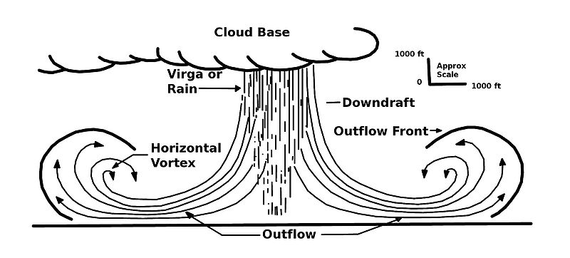
The next figure is a schematic cross section of a downburst
And here is an excellent example of a downburst cloud with a similar bulbous cloud formation as in the Star Valley event. This series of photos was taken in the Fall of 1991 in Oklahoma.

The radar Composite Reflectivity image showing the storm approaching from the west was not particularly strong
 | ||
| Pocatello Composite Reflectivity Image around 7:30 PM MDT |

The Star Valley Ranch weather station has a dramatic display of not only the 48 mph wind gust, but the very sharp pressure jump and temperature drop as the storm passed.( about 40 minutes need to be added to this graphic as the internal weather station clock was found to be in error.)
No comments:
Post a Comment