Riverton WFO has put together an excellent discussion of this weekends storm system for western Wyoming including the Star Valley region.
http://www.crh.noaa.gov/riw/?n=weatherbriefing
Friday, November 30, 2012


Tuesday, November 27, 2012
Stormy Weekend Ahead
Over the Thanksgiving weekend the storm that crossed Wyoming resulted in some snow in Star Valley and more in the higher elevations. However there was a swath of around a foot of new snow that tracked across the Tetons and the Absaroka Ranges with upward to a foot and a half in parts of the Tetons.
So far High pressure has dominated through Tuesday of this week and one more day of dry and relatively mild weather is on tap for Wednesday. As can be seen on this Tuesday evenings satellite photos, the Northeastern Pacific Ocean is dominated by very active storms.
The following series of 500mb forecast charts over the next 6 days shows the progression of the deep trough now off the west coast.
The sequence is every two days showing the steady progression of the large trough to a position east of Wyoming over the central states by Monday evening.
This pattern supports an extended period of precipitation across western Wyoming including Star Valley. It should begin by later Thursday/Thursday night and continue through the weekend. The snow level will fluctuate through Saturday with rain and snow in Star Valley and potentially heavy amounts of snow in the higher mountains. By Sunday it should be all snow in the valley as the cold trough moves inland. The following graphic shows the model forecast total precipitation from Wednesday through Monday. While amounts range upward to 1-2 inches in the higher mountains of Northwest Wyoming, note the very large totals in parts of Northern California.
Between 10-15 inches of rain are indicated which if verifying could result in a serious flood threat.
Eureka CA WFO has addressed this threat with the following graphic.

 | ||
 | ||
| Water Vapor Imagery |
 | ||
| Infrared Imagery with surface analysis Tuesday Evening |
 |
| Tue Evening |
 |
| Thursday Evening |
 |
| Saturday Evening |
 |
| Monday Evening |
The sequence is every two days showing the steady progression of the large trough to a position east of Wyoming over the central states by Monday evening.
This pattern supports an extended period of precipitation across western Wyoming including Star Valley. It should begin by later Thursday/Thursday night and continue through the weekend. The snow level will fluctuate through Saturday with rain and snow in Star Valley and potentially heavy amounts of snow in the higher mountains. By Sunday it should be all snow in the valley as the cold trough moves inland. The following graphic shows the model forecast total precipitation from Wednesday through Monday. While amounts range upward to 1-2 inches in the higher mountains of Northwest Wyoming, note the very large totals in parts of Northern California.
 | ||
| Total Precipitation forecast from Wednesday through Monday December 3rd. |
Eureka CA WFO has addressed this threat with the following graphic.

Saturday, November 24, 2012
Warm Octobers Continue
It was an unseasonably mild October 2012 in Star Valley, but now that the data is in it is clear much of the earth also experienced anomalously warm conditions.
With the exception of western Canada down into the Central U.S. and eastern Asia above normal temperatures were the rule over land and sea.
In fact warm Octobers have been the rule world wide for much of the past 30 years!
A possible indicator of the warm temperatures is the extent of sea ice observed over the polar regions in October.
The first graph shows the loss of sea ice over the north polar areas in recent years as measured in October.
 While the record is relatively short, the warmth appears to have taken its toll since 2000.
On the other hand the south polar sea ice has actually shown some increase in recent years
 With the polar opposite signals, the cause and effect is in question although it appears that the warmth is well correlated to sea ice loss in the north pole region.
Comparing the daily high/low temperatures with normal and record readings for Jackson WY in October 2012 there were no record setting periods. There was a particularly cold period actually in the first part of October and then ending up well above normal
 So far in November after a very warm start, there was a period of below normal temperatures during the second week of the month. However since then it has been generally mild with above normal temperatures

It now appears after a quick moving system drops a couple inches of snow on Sunday, the remainder of November should be dry and seasonably mild. The CPC forecast for the coming weekend suggest the mild conditions should extend into the first of December.

Much of the country should experience above normal temperatures through the weekend!
Additionally a moist air mass will spread inland on the West Coast in advance of a major Pacific low pressure trough bringing above normal precipitation into Northern/Central California and Oregon.
Affects from the moist flow could reach into Star Valley over the weekend.
The extended model precipitation forecast covering the period from midnight Wednesday through midnight Sunday shows the potential for a major heavy rain event over Northern California.

 | |
In fact warm Octobers have been the rule world wide for much of the past 30 years!
 | ||||
The first graph shows the loss of sea ice over the north polar areas in recent years as measured in October.
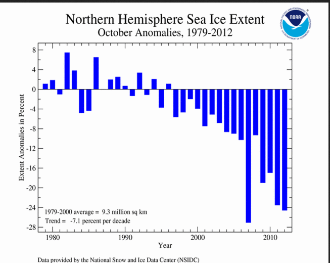
On the other hand the south polar sea ice has actually shown some increase in recent years

Comparing the daily high/low temperatures with normal and record readings for Jackson WY in October 2012 there were no record setting periods. There was a particularly cold period actually in the first part of October and then ending up well above normal


It now appears after a quick moving system drops a couple inches of snow on Sunday, the remainder of November should be dry and seasonably mild. The CPC forecast for the coming weekend suggest the mild conditions should extend into the first of December.

Much of the country should experience above normal temperatures through the weekend!
Additionally a moist air mass will spread inland on the West Coast in advance of a major Pacific low pressure trough bringing above normal precipitation into Northern/Central California and Oregon.
 | ||
The extended model precipitation forecast covering the period from midnight Wednesday through midnight Sunday shows the potential for a major heavy rain event over Northern California.

Monday, November 19, 2012
WYOMING RECORD LOW TEMPERATURE
While recent weather records are typically quite accurate given the modern day instrumentation and GIS capabilities, errors are being found in some of the older ones. A couple of examples that have been noted recently in this blog are the Worlds highest temperature
http://starvalleywyweather.blogspot.com/2012/09/worlds-hottest-temperature-moves-to.html
and the location of the historic Teton Tornado in 1987
http://starvalleywyweather.blogspot.com/2012/07/teton-tornado-25-years-ago.html
Another record that has been questioned recently is the Wyoming all-time coldest temperature. There is a blog that addresses this and other very interesting global record cold sites.
http://www.wunderground.com/blog/weatherhistorian/comment.html?entrynum=12
For many years there has been confusion surrounding the actual location of the Riverside Ranger Station that recorded a temperature of -66°F on Feb. 9, 1933. This figure has long been erroneously reported as the coldest temperature ever measured in Wyoming (See NCDC site for instance). The problem is that this (no longer existing) ranger station was actually located in the Montana section of Yellowstone National Park. It was situated where the town of West Yellowstone, Montana now resides.
The reason for this confusion originates from the fact that the Climatological Data by Sections USWB report for February 1933 includes Yellowstone National Park in its Wyoming section even though portions of the park, including the site of Riverside R.S., are in Montana and Idaho. If one looks at the station I.D. number (248857) on the Western Regional Climate Center’s station summaries lists we see that the site was established in 1924 (when the ranger station was established) and then continues at the same location in later years as “West Yellowstone, Montana”.
Also, I have personally(Christopher Burt the blogger) visited this area and investigated the location of the ranger station and can confirm that the site was in Montana when it was built in 1924 (by only 200 yards!). The actual record low for the state of Wyoming is -63°F at Moran on that same night of Feb. 9, 1933.

This map from 1929 shows the exact location of the Riverside Ranger Station. It is just sandwiched between the border of the national park (the large green border) and the border between Wyoming and Montana (the small dashed border). The name of the ranger station is not given, it just says "ranger station" but this is, in fact, the Riverside Ranger Station (named 'Riverside') because it is by the Madison River. One can understand the confusion of the location so far as being in Wyoming or Montana.
Thursday, November 15, 2012
A Good Start
After 7 days of clouds and snow, brilliant blue skies have returned to Star Valley

At Star Valley Ranch(location of above photo), snow depth Thursday morning was 7 inches, with a total of 19 inches falling in the past week. This brings the water year total since Oct. 1 2012 to 31 inches of snow with 3.28 inches water content. At the CoCoRaHS site located 5 mi. S of Smoot, since Oct 1st precipitation totals 3.11 inches.
After such a dry summer and low snow pack last winter, it is an encouraging beginning to this year's snow season.
The SNOTEL sites in the Salt River Range are showing a good start to the snow pack.


The following table provides more detailed data of the snow pack from the surrounding area including the Tetons.

Looking ahead the flow pattern will lead to a large trough off the West Coast and milder southwesterly flow into western Wyoming.
Thursday morning's 500mb analysis
indicates high pressure ridging over much of the west which transition to an intense trough off the West Coast by the weekend as a weaker upper low off the California coast moves inland.
Thursday a.m. Water Vapor Imagery shows a large area of clouds associated with the upper low off California and a developing strong system in the Gulf of Alaska.
Model forecast precipitation through Saturday morning is confined to the coastal states with mostly dry conditions in Wyoming. The clouds from the weakening upper low moving into California will spread into western Wyoming with the possibility of some light precipitation.
Over the weekend the mild southwest flow continues across Star Valley, with most of the precipitation remaining to the west and north of Star Valley.
The low pressure trough moves inland across the Northern Rockies by Monday a.m.
and will lead to some precipitation into Star Valley. Mountain snows and valley rain/snow showers will be likely Sunday and Monday.

At Star Valley Ranch(location of above photo), snow depth Thursday morning was 7 inches, with a total of 19 inches falling in the past week. This brings the water year total since Oct. 1 2012 to 31 inches of snow with 3.28 inches water content. At the CoCoRaHS site located 5 mi. S of Smoot, since Oct 1st precipitation totals 3.11 inches.
After such a dry summer and low snow pack last winter, it is an encouraging beginning to this year's snow season.
The SNOTEL sites in the Salt River Range are showing a good start to the snow pack.


Looking ahead the flow pattern will lead to a large trough off the West Coast and milder southwesterly flow into western Wyoming.
Thursday morning's 500mb analysis
 | |||
| 500mb analysis Thursday am 11/15/12 |
 | ||
| 500mb forecast Saturday morning 11/17/12 |
 |
| WV Imagery Thursday am 11/15/12 |
Model forecast precipitation through Saturday morning is confined to the coastal states with mostly dry conditions in Wyoming. The clouds from the weakening upper low moving into California will spread into western Wyoming with the possibility of some light precipitation.
 | ||||
| Model forecast precipitation 48 hours through Saturday am 11/17/12 |
 | ||
| Model forecast precipitation 48 hours through Monday am 11/19/12 |
 |
| 500mb forecast Monday am 11/19/12 |
Saturday, November 10, 2012
Departing Storm with a Quiet Weather Week Ahead
The cold winter storm that engulfed Star Valley and the surrounding region Friday will be heading on to the east Sunday. While snow flurries will be possible again Sunday, the substantial snow from this storm will be essentially over. Here is a list of snow reports in Lincoln County from the storm through Saturday afternoon.
While the snow is over, except for lingering flurries, the cold air will be the weather story through Monday. Temperatures which remained below freezing Saturday afternoon, will fall to the coldest levels since early last March on Sunday and Monday mornings. There is the potential of the first subzero readings in the coldest valley locations. Only if the clouds linger will temperatures not drop to, or below zero.
Beginning Monday afternoon, the weather pattern will transition into one that has been common much of the Fall. A westerly flow along with mild temperatures will return.
By mid week much of the U.S. will be under a westerly flow with little significant storm activity.
While still almost two weeks away, the Climate Prediction Center indicates both a mild and dry weather regime over much of the U.S. through the Thanksgiving Holiday.
LINCOLN COUNTY...
 3 SE BEDFORD...                     14 INCHES.
 WILLOW CREEK SNOTEL...              12 INCHES.
 5 NNE THAYNE(STAR VALLEY RANCH)...  10.5 INCHES.
 AFTON...                           8.5 INCHES.
 1 W SMOOT...                         8 INCHES.
 2 SE THAYNE...                       7 INCHES.
 FAIRVIEW...                          7 INCHES.
 COTTONWOOD CREEK SNOTEL...           6 INCHES.
 AFTON...                             6 INCHES.
 5 SSE SMOOT...                       6 INCHES.
 SALT RIVER SUMMIT SNOTEL...          6 INCHES.
 BLIND BULL SUMMIT...                 5 INCHES.
 BLIND BULL SUMMIT SNOTEL...          4 INCHES.
 INDIAN CREEK SNOTEL...               4 INCHES.
 KELLEY RANGER STATION SNOTEL...      4 INCHES.
 ALPINE...                            3 INCHES.
 HAMS FORK SNOTEL...                  3 INCHES.
 BOX Y RANCH...                       2 INCHES.
 KEMMERER...                          1 INCH.
 SPRING CREEK DIVIDE SNOTEL...        1 INCH.
 | ||
| Wintry Sunset at Star Valley Ranch Saturday 11/10/12 |
The heaviest snow occurred along the east side of the valley from
Etna to Afton, with Bedford/Turnerville measuring over a foot.
Riverton WFO has provided a comprehensive summary of the Storm across Western Wyoming
http://www.crh.noaa.gov/news/display_cmsstory.php?wfo=riw&storyid=89230&source=0
The 500mb analysis with satellite imagery for Saturday evening shows the coldest portion of the system is moving across Star Valley. | ||||
| Saturday Evening 500mb analysis |
Beginning Monday afternoon, the weather pattern will transition into one that has been common much of the Fall. A westerly flow along with mild temperatures will return.
By mid week much of the U.S. will be under a westerly flow with little significant storm activity.
 | ||
| Wednesday evening 500mb forecast 11/14/12 |
 | ||
| Temperature forecast Nov 18-24 2012 |
 | ||||
| Precipitation forecast Nov 18-24 2012 |
Thursday, November 8, 2012
One More Day
The advertised arrival of Winter weather to Star Valley is on schedule. While the winds will be up this Thursday afternoon, temperatures will remain relatively balmy. However the mornings satellite infra-red photo clearly shows the major upper low pressure trough and associated cold air that is now moving into the western states.
The following sequence of 700mb charts(around 10,000 feet MSL) graphically shows the cold air spreading eastward across much of the western states through the weekend.
The model forecast temperatures through the weekend have readings dropping below freezing later this Thursday night and remaining cold through Sunday.
While the confidence is high on the cold air arriving by Friday morning, the amount of snowfall is still somewhat uncertain. Initially the system does not contain much moisture, however as it develops east across the mountain west and is lifted by the terrain, snow will fall. It now appears that the more significant area of snow will occur across Montana and the higher elevations of Utah and Wyoming. Here in Star Valley, a few inches are likely to fall over the two day period of Friday and Saturday.
Again the model forecast precipitation for the 72 hour period ending Sunday am
 | ||
| 9am Thursday 11/8/12 |
 | |
| Thursday am 11/8/12 |
 | |
| Friday am 11/9/12 |
 | ||
| Saturday am 11/10/12 |
 | ||
| Sunday am 11//11/12 |
 | |||
| Model forecast temperatures for Star Valley in degrees F |
While the confidence is high on the cold air arriving by Friday morning, the amount of snowfall is still somewhat uncertain. Initially the system does not contain much moisture, however as it develops east across the mountain west and is lifted by the terrain, snow will fall. It now appears that the more significant area of snow will occur across Montana and the higher elevations of Utah and Wyoming. Here in Star Valley, a few inches are likely to fall over the two day period of Friday and Saturday.
Again the model forecast precipitation for the 72 hour period ending Sunday am
 |
| Model precipitation Thu am through Sun am |
Subscribe to:
Posts (Atom)