Wednesday, February 18, 2015

Northwest States Ski Season much worse than Western Wyoming


While Star Valley and Western Wyoming have experienced little snow in the month of February, higher elevation snowpack remains near or just slightly below normal.  Such is not the case in much of the western states.  While precipitation in the Pacific Northwest has been generous, the abnormally mild winter has resulted in poor snow accumulations .  Jim Steenburgh has blogged about the disastrous  ski season thus far.  


A Northwest Ski Disaster

Even if the pattern shifts and starts producing heavy snowfall, the winter of 2014-2015 will probably go down as one of the worst if not the worst snow years in Pacific Northwest history.

The ski season has been an unmitigated disaster.  Snoqualmie Pass is home to four ski areas, all with base elevations near 3,000 feet.  Here's what it looked like at the Summit Central ski area this morning.
Source: http://www.summit-at-snoqualmie.com/
How bad is this year?  Data collected by the Washington Department of Transportation shows that Snoqualmie Pass averaged 400" of snow the past five winters.  The average accumulation by February 10th was 205".  This year they've had 79" and obviously a lot of that snow has melted.

If you have a season's pass for the Snoqualmie Pass ski areas, Crystal Mountain will let you ride for free, but if you go there, here's what you'll find.
http://crystalmountainresort.com/
Yup, no snow at the base.  What's open?  The upper mountain Green Valley Express chair, with access provided by the Mt. Rainier Gondola.  The upper mountain doesn't look half bad, but the photo above looks more like late May than mid February.

Paradise Ranger Station on Mt. Rainier is one of the snowiest places in the world, but not this year.  SNOTEL data from Paradise shows that they've had plenty of precipitation (compare black and grey lines) and are actually a bit above average since the start of the water year on October 1st.  However, much of that precipitation has fallen in the form of rain and the amount of water retained in the snowpack is well below average (compare blue and red lines).
Source: NRCS
There is actually a remarkably long record of snowfall kept by the National Park Service at Paradise Ranger Station.  The record low snowfall is 313" in 1939–40.

Thursday, February 12, 2015

Colder Weather on the Way

The weekly weather video issued by Riverton Forecast Office highlights the change to colder by the first of the week.


Weekly Weather Video

Wednesday, February 11, 2015

Water Supply Outlook as of February 9 2015

Wyoming Water Supply Outlook---issued February 9th

…Wyoming January precipitation was nearly 70 percent of average...
...Current water year precipitation is averaging near 95 percent of normal across Wyoming…
…Mountain snowpack across Wyoming is 90 to 95 percent of average... 
…Below normal snowmelt streamflow volumes are expected across major basins in Wyoming...
…Wyoming carryover reservoir storages are 115 to 125 percent of average for February…

....Synopsis...

January precipitation totals across Wyoming were nearly 70 percent of average. Precipitation numbers varied between 119 percent of normal over the Big Horn River Basin to near 32 percent of normal over the Little Snake Drainage (South Central Wyoming).  Current water year (October 2014 - January 2015) precipitation across Wyoming is nearly 95 percent of average.
Mountain snowpack across Wyoming was 90 to 95 percent of normal by early February.  Snowpack "water" numbers and/or SWEs were the highest across basins in northern Wyoming---varying between 105 to 125 percent of median.  SWEs across basins in southern Wyoming varied between 75 to 100 percent of median.
Below normal (85 to 95 percent) snowmelt streamflow volumes are expected across almost all major basins across Wyoming.  Slightly above average streamflow volumes are expected across the Yellowstone/Clarks Fork as well as portions of the Powder River Drainage.  Several southern drainages—including the Sweetwater, the Little Snake,  the North Platte, the Laramie, and the Bear---are forecasted to have below normal streamflow volumes during the upcoming snowmelt season.
Carryover reservoirs storages across Wyoming are above average (greater than 115 percent) for February. 
The latest Wyoming water supply outlook graphic:


Thursday, February 5, 2015

Wednesday, February 4, 2015

Final Snow Report Feb 2-4 2015


Snowfall Reports
CountyStation NameSnowfall
Big Horn26 E Lovell3.5
Big HornBone Springs Divide Snotel3
Big HornShell Creek Snotel3
Big HornBald Mountain Snotel2
Big HornShell1.5
Big Horn2 SSW Lovell1.5
Big HornBasin1
Big HornLovell1
Fremont10 W Dubois9.5
FremontBrooks Lake9
FremontLittle Warm Snotel7
FremontCastle Creek Snotel6
FremontCold Springs Snotel6
FremontBurroughs Creek Snotel5
FremontDeer Park Snotel5
FremontDubois5
FremontHudson4.5
FremontRiverton4-4.2
FremontAtlantic City4
FremontSouth Pass Snotel4
FremontLander Airport3.4
FremontLander2-3.3
Fremont6 SW Lander3.1
FremontHobbs Park Snotel3
FremontRiverton Airport3
FremontBurris3
Fremont7 WNW Lander2.3
Fremont7 ESE Kinnear2
FremontTownsend Creek Snotel2
FremontSt. Lawrence Alt Snotel2
Fremont10 NW Riverton2
Fremont9 S Lander2
Fremont9 SSE Lander1.5
Fremont6 SE Lander1.5
Fremont15 W Jeffrey City1
FremontBoysen Dam1
Hot SpringsThermopolis3.2
Hot SpringsOwl Creek Snotel3
Hot Springs9 NE Thermopolis2.6
Hot SpringsKirby2.5
JohnsonBear Trap Meadow Snotel5
JohnsonHansen Sawmill Snotel4
Johnson1 NW Buffalo4
JohnsonLittle Goose Snotel3
JohnsonSoldier Park Snotel2
JohnsonKaycee2
JohnsonCloud Peak Reservoir Snotel2
Johnson17 E Kaycee1.8
JohnsonBuffalo1.2
LincolnWillow Creek Snotel16
LincolnSpring Creek Divide Snotel14
LincolnCottonwood Creek Snotel13
LincolnBlind Bull Summit12
LincolnIndian Creek Snotel11
LincolnBlind Bull Summit Snotel10
LincolnSalt River Summit Snotel8
LincolnCommissary Ridge8
LincolnHams Fork Snotel7
LincolnKelley Ranger Station Snotel7
LincolnBox Y Ranch2
Lincoln2 SE Thayne0.7
LincolnAfton0.5
NatronaReno Hill Snotel6
NatronaGrave Spring Snotel6
NatronaPowder River5
NatronaCasper4
Natrona5 SSW Casper3.5
NatronaMidwest3-3.5
Natrona10 WSW Casper3
NatronaCasper Airport2.9
NatronaCasper Mountain Snotel1
ParkBlackwater Snotel6
Park3 NE Sunshine5.1
ParkTimber Creek Snotel5
ParkMeeteetse4-4.5
Park8 WSW Meeteetse4
ParkKirwin Snotel4
ParkWolverine Snotel3
ParkEvening Star Snotel3
Park26 SW Cody2.5
ParkMarquette Snotel2
ParkPahaska2
Park3 W Wapiti1.6
Park2 WSW Cody1.5
Park1 W Cody1.5
Park5 ESE Cody1.5
ParkCody1.3
Park3 NE Clark0.5
SubletteTriple Peak Snotel17
SubletteGunsite Pass Snotel10
SubletteLoomis Park Snotel10
SubletteSnider Basin Snotel9
SubletteBig Sandy Opening Snotel8
SublettePocket Creek Snotel8
SubletteKendall Ranger Station Snotel7
SubletteLarsen Creek Snotel7
Sublette15 WNW Daniel7
SubletteNew Fork Lake Snotel6
SubletteDaniel6
SubletteElkhart Park G.S. Snotel6
SubletteDaniel Fish Hatchery5.2
SubletteEast Rim Divide Snotel5
Sublette14 NW Pinedale4
Sublette1 N Pinedale3.5
SublettePinedale3.2
SubletteBoulder Rearing Station1
SubletteBig Piney1
TetonPhillips Bench Snotel20
TetonGrand Targhee Snotel18
TetonTogwotee Pass Snotel14
TetonJackson Hole - Mid Mountain13
TetonJackson Hole - Rendezvous Bowl13
TetonJackson Hole - Raymer13
TetonGros Ventre Summit Snotel11
TetonGranite Creek Snotel11
TetonGrassy Lake Snotel10
TetonBase Camp Snotel9
TetonGrand Targhee - Chief Joseph9
TetonTogwotee Mountain Lodge8
TetonSnake River Stn Snotel5
TetonJackson Hole - Base4
Teton1 ENE Teton Village3.5
TetonMoose3
Teton12 NE Jackson2.5
TetonSnow King2
Teton12 NE Jackson2
TetonJackson1
WashakiePowder River Pass Snotel6
Washakie16 SSE Ten Sleep3.5
WashakieMiddle Powder Snotel3
WashakieTen Sleep2.3
Washakie5 NNW Ten Sleep1.1
Washakie8 SW Worland1
YellowstoneTwo Ocean Plateau Snotel8
YellowstoneLewis Lake Divide Snotel6
YellowstoneParker Peak Snotel4
YellowstoneEast Entrance Ranger Station3.5
YellowstoneSylvan Road Snotel3
YellowstoneCanyon Snotel3
YellowstoneSylvan Lake Snotel2
YellowstoneOld Faithful Ranger Station1.5
YellowstoneThumb Divide Snotel1
YellowstoneTower Falls Ranger Station1
YellowstoneLamar Ranger Station0.5

Tuesday, February 3, 2015

Storm Snow Totals as of 5 PM Tuesday

UBLIC INFORMATION STATEMENT
NATIONAL WEATHER SERVICE RIVERTON WY
513 PM MST TUE FEB 3 2015

THE SECOND ROUND OF SNOW OCCURRED MONDAY NIGHT
INTO TUESDAY MORNING OVER WESTERN AND CENTRAL
WYOMING. HERE ARE SOME OF THOSE SNOWFALL AMOUNTS.

LOCATION                             SNOWFALL
LINCOLN COUNTY...
 WILLOW CREEK SNOTEL...              12 INCHES.
 BLIND BULL SUMMIT...                 7 INCHES.
 COTTONWOOD CREEK SNOTEL...           7 INCHES.
 BLIND BULL SUMMIT SNOTEL...          7 INCHES.
 COMMISSARY RIDGE...                  5 INCHES.
 SPRING CREEK DIVIDE SNOTEL...        4 INCHES.
 BOX Y RANCH...                       4 INCHES.
 SALT RIVER SUMMIT SNOTEL...          3 INCHES.
 KELLEY RANGER STATION SNOTEL...      3 INCHES.
 STAR VALLEY RANCH                    2 INCHES 
 5 SSE SMOOT...                       1 INCH.
 HAMS FORK SNOTEL...                  1 INCH.
 INDIAN CREEK SNOTEL...               1 INCH.
 3 SE BEDFORD...                    0.5 INCHES.
 2 SE THAYNE...                     0.2 INCHES.
BIG HORN COUNTY... BONE SPRINGS DIVIDE SNOTEL... 4 INCHES. BALD MOUNTAIN SNOTEL... 3 INCHES. FREMONT COUNTY... BROOKS LAKE... 4 INCHES. BURROUGHS CREEK SNOTEL... 3 INCHES. HOT SPRINGS COUNTY... OWL CREEK SNOTEL... 1 INCH. JOHNSON COUNTY... LITTLE GOOSE SNOTEL... 1 INCH. CLOUD PEAK RESERVOIR SNOTEL... 1 INCH. SOLDIER PARK SNOTEL... 1 INCH. HANSEN SAWMILL SNOTEL... 1 INCH. NATRONA COUNTY... GRAVE SPRING SNOTEL... 1 INCH. PARK COUNTY... BLACKWATER SNOTEL... 7 INCHES. BEARTOOTH LAKE SNOTEL... 4 INCHES. KIRWIN SNOTEL... 1 INCH. WOLVERINE SNOTEL... 1 INCH. PAHASKA... 1 INCH. EVENING STAR SNOTEL... 1 INCH. MARQUETTE SNOTEL... 1 INCH. SUBLETTE COUNTY... GUNSITE PASS SNOTEL... 5 INCHES. SNIDER BASIN SNOTEL... 5 INCHES. TRIPLE PEAK SNOTEL... 5 INCHES. ELKHART PARK G.S. SNOTEL... 4 INCHES. NEW FORK LAKE SNOTEL... 3 INCHES. LOOMIS PARK SNOTEL... 3 INCHES. 14 NW PINEDALE... 1.4 INCHES. EAST RIM DIVIDE SNOTEL... 1 INCH. KENDALL RANGER STATION SNOTEL... 1 INCH. BIG SANDY OPENING SNOTEL... 1 INCH. PINEDALE... 0.2 INCHES. DANIEL FISH HATCHERY... 0.2 INCHES. TETON COUNTY... PHILLIPS BENCH SNOTEL... 9 INCHES. JACKSON HOLE - RAYMER... 7.5 INCHES. GRASSY LAKE SNOTEL... 7 INCHES. GRAND TARGHEE SNOTEL... 5 INCHES. JACKSON HOLE - MID MOUNTAIN... 5 INCHES. JACKSON HOLE - RENDEZVOUS BOWL... 5 INCHES. GRAND TARGHEE - CHIEF JOSEPH... 3 INCHES. TOGWOTEE MOUNTAIN LODGE... 3 INCHES. TOGWOTEE PASS SNOTEL... 3 INCHES. MOOSE 0.4 SOUTH... 3 INCHES. GRANITE CREEK SNOTEL... 3 INCHES. JACKSON HOLE - BASE... 2 INCHES. SNOW KING... 2 INCHES. MOOSE... 1.6 INCHES. 12 NE JACKSON... 1 INCH. SNAKE RIVER STN SNOTEL... 1 INCH. 2 NE TETON VILLAGE... 1 INCH. BASE CAMP SNOTEL... 1 INCH. GROS VENTRE SUMMIT SNOTEL... 1 INCH. YELLOWSTONE NATIONAL PARK... LEWIS LAKE DIVIDE SNOTEL... 7 INCHES. TWO OCEAN PLATEAU SNOTEL... 7 INCHES. PARKER PEAK SNOTEL... 6 INCHES. YELLOWSTONE EAST ENTRANCE... 1.5 INCHES. SYLVAN LAKE SNOTEL... 1 INCH. THUMB DIVIDE SNOTEL... 1 INCH. CANYON SNOTEL... 1 INCH.

Sunday, February 1, 2015

Snow and Possibly Rain Return to Star Valley

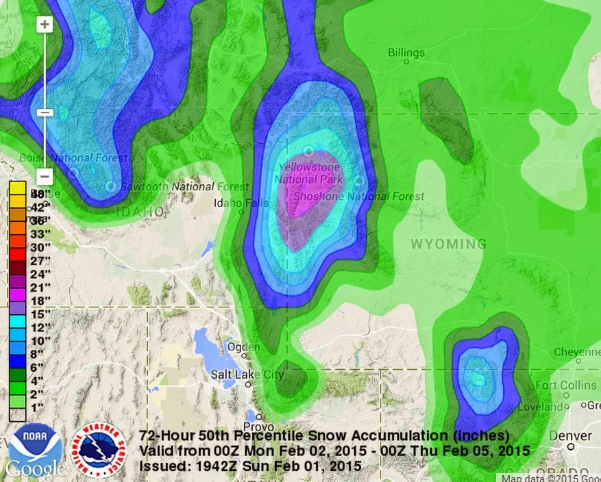
After a basically snowless two weeks the later half of January, Star Valley is seeing to a return of more typical mid-winter conditions.  Snow is being reported from much of Northwest Wyoming including Star Valley this Sunday evening. A flow of moist Pacific air has spread across the Pacific Northwest into northwest Wyoming, and will continue for the next 3 days.  The real question is where will the snow level be at during the event as the air mass is relatively warm for February.

There is considerable confidence that substantial precipitation  will occur from Star Valley northward to Yellowstone Park with a couple feet of snow in the higher mountains. The latest computer model forecast precipitation for the next 3 days  clearly focuses the precipitation in this area.

72 Hour total precipitation ending Wednesday evening Feb 4 2015

 The 500mb wind pattern shows the flow from off the Pacific with the cold air remaining well to the north and east of Western Wyoming.

500mb analysis Sunday evening Feb 1 2015

A forecast of the vertical profile of  temperature and moisture over Star Valley for Tuesday evening show the deep moisture and strong westerly flow, along with the freezing level about 7500 feet.

model sounding over Star Valley Tue pm Feb 3 2015
This moist and relatively warm profile support snow either mixing with rain at times or possibly turning to rain over the next 3 days.  Nevertheless there is potential for significant amount of wet snow, particularly higher elevations of the Valley,  near or above 6500 feet.

The NWS forecasters at the Weather Prediction Center provide a 72 hour accumulation of snow ending Wednesday evening.  They are predicting a 50 percent chance of well over a foot in the higher elevations from Star Valley to Yellowstone NP. Near 2 feet is being forecast for locations such as the Tetons and possibly the northern Wyoming and Salt Ranges as well.