Wednesday, December 12, 2012

Record Warm 2012 in Utah

Dr. Jim Steenburgh who is an active blogger and a meteorology professor at the University of Utah, posted a blog on how unusually warm it has been in 2012 across Utah.  Here in Star Valley we have experienced a comparatively warm year as well. I have reproduced his blog below and if you have an interest in following Jim, you can see his posting at the following link:

http://wasatchweatherweenies.blogspot.com/

 A Big Record Will Likely Fall

Source: www.mattbors.com
This has been an exceptional year meteorologically in Utah.  One that lies outside the range of weather that has been recorded previously (since 1895) in the state.

For the year to date (Jan–Nov), our mean statewide temperature is 53.7ºF, the highest in the instrumented record.

Source: NCDC
A close second is 1934 at 53.4ºF (I'm not sure if the difference is statistically significant, but we'll go with 2012 as the leader).  1934 was a real outlier relative to the climate of Utah during the early 20th century.  In fact, despite warmth in recent years, none have exceeded it.  Will we finally top it this year?

Data from NCDC suggests that in December 1934 the statewide average temperature was 1.1ºF above the 1981–2010 statewide average temperature.  I don't have access to statewide statistics for the first 12 days of this December, but we can look at anomalies at specific stations.  At Salt Lake City we ran  7.6ºF above the 1981–2010 average.  At Cedar City we ran 8.0ºF above the 1981–2010 average.  Now that's a fever!

Thus, we head into the last half of December with a very real chance of recording the warmest calendar  year in Utah during the instrumented record.  That sounds impressive, but in the coming decades, this year won't seem all that unusual.  

Saturday, December 8, 2012

Very Cold Night in Wake of Wyoming Storm

The winter storm that brought high winds,snow and much colder air to the Cowboy state had moved onto the east this Saturday evening.  In its wake temperatures have dropped rapidly to below zero in many areas of western Wyoming.  As of 10 PM parts of Star Valley are near or below zero with Thayne ES at zero and 4 below just northwest of Etna along the Salt River.  To the east Bondurant had already dipped to 14 below.  With the skies having cleared, temperatures will continue to drop with 10 to 15 below possible in coldest Star Valley areas and 20 below in coldest valleys of Western Wyoming such as Bondurant.

Riverton Forecast Office has compiled as excellent summary of the storm.  Note the wind gust to 130 mph on Mt Coffin early Saturday morning.  The observations site is above 10,000 feet in the Wyoming Range.

http://www.crh.noaa.gov/news/display_cmsstory.php?wfo=riw&storyid=90119&source=0

Storm Snow Totals

The cold front charged through Star Valley around 8 am this morning with briefly near blizzard conditions.  Winds gusted as high as 43 mph at the Star Valley Ranch weather station at 8:20 am.  Colder, drier air is spreading across the area and temperatures Sunday morning will dip to near or below zero in much of Star Valley. The typically colder locations could fall to as low as 10 below zero.

Here is a list put together by the Riverton Forecast Office of the snowfall amounts over Western Wyoming up to 8 am Saturday.


NATIONAL WEATHER SERVICE RIVERTON WY
844 AM MST SAT DEC 8 2012


LOCATION                             SNOWFALL
LINCOLN COUNTY...
 SPRING CREEK DIVIDE SNOTEL...       10 INCHES.
 BLIND BULL SUMMIT SNOTEL...          9 INCHES.
 BLIND BULL SUMMIT...                 9 INCHES.
 WILLOW CREEK SNOTEL...               9 INCHES.
 2 SE THAYNE...                     7.5 INCHES.
 BOX Y RANCH...                       7 INCHES.
 5 NNE THAYNE(Star Valley Ranch)...   7 INCHES.
 COTTONWOOD CREEK SNOTEL...           5 INCHES.
 SALT RIVER SUMMIT SNOTEL...          5 INCHES.
 INDIAN CREEK SNOTEL...               4 INCHES.
 KELLEY RANGER STATION SNOTEL...      3 INCHES.
 HAMS FORK SNOTEL...                  3 INCHES.
BIG HORN COUNTY... 26 E LOVELL... 3 INCHES. FREMONT COUNTY... SOUTH PASS SNOTEL... 7 INCHES. DEER PARK SNOTEL... 5 INCHES. CASTLE CREEK SNOTEL... 3 INCHES. BURROUGHS CREEK SNOTEL... 3 INCHES. LITTLE WARM SNOTEL... 3 INCHES. BROOKS LAKE LODGE... 2 INCHES. COLD SPRINGS SNOTEL... 1 INCH. TOWNSEND CREEK SNOTEL... 1 INCH. HOBBS PARK SNOTEL... 1 INCH. ST. LAWRENCE ALT SNOTEL... 1 INCH. PARK COUNTY... EVENING STAR SNOTEL... 4 INCHES. BLACKWATER SNOTEL... 3 INCHES. YOUNTS PEAK SNOTEL... 3 INCHES. PAHASKA... 2 INCHES. 2 WSW CODY... 1 INCH. KIRWIN SNOTEL... 1 INCH. 5 ESE CODY... 1 INCH. 4 ENE POWELL... 0.4 INCHES. SUBLETTE COUNTY... SNIDER BASIN SNOTEL... 10 INCHES. TRIPLE PEAK SNOTEL... 7 INCHES. KENDALL RANGER STATION SNOTEL... 7 INCHES. LARSEN CREEK SNOTEL... 5 INCHES. LOOMIS PARK SNOTEL... 5 INCHES. EAST RIM DIVIDE SNOTEL... 5 INCHES. ELKHART PARK G.S. SNOTEL... 4 INCHES. BIG SANDY OPENING SNOTEL... 4 INCHES. NEW FORK LAKE SNOTEL... 4 INCHES. 14 NW PINEDALE... 3.8 INCHES. GUNSITE PASS SNOTEL... 3 INCHES. POCKET CREEK SNOTEL... 3 INCHES. SWEETWATER COUNTY... 1 W ROCK SPRINGS... 3.5 INCHES. 1 E ROCK SPRINGS... 1.9 INCHES. TETON COUNTY... JACKSON HOLE-RENDEZVOUS BOWL... 11 INCHES. JACKSON HOLE-RAYMER... 9 INCHES. 3 SSW WILSON... 8.2 INCHES. PHILLIPS BENCH SNOTEL... 7 INCHES. BASE CAMP SNOTEL... 7 INCHES. GRANITE CREEK SNOTEL... 7 INCHES. JACKSON HOLE-MID... 7 INCHES. SNOW KING SKI AREA... 6 INCHES. MOOSE... 4 INCHES. 2 SW TETON VILLAGE... 4 INCHES. SNAKE RIVER STN SNOTEL... 4 INCHES. JACKSON HOLE-BASE... 3 INCHES. GROS VENTRE SUMMIT SNOTEL... 3 INCHES. GRASSY LAKE SNOTEL... 3 INCHES. GRAND TARGHEE-CHIEF JOSEPH... 3 INCHES. TOGWOTEE PASS SNOTEL... 3 INCHES. 4 SSW JACKSON... 2.9 INCHES. TOGWOTEE MOUNTAIN LODGE... 2 INCHES. YELLOWSTONE NATIONAL PARK... TWO OCEAN PLATEAU SNOTEL... 7 INCHES. LEWIS LAKE DIVIDE SNOTEL... 4 INCHES. PARKER PEAK SNOTEL... 3 INCHES. SYLVAN LAKE SNOTEL... 1 INCH. THUMB DIVIDE SNOTEL... 1 INCH. SYLVAN ROAD SNOTEL... 1 INCH. $$

Wednesday, December 5, 2012

Winter is Coming to Star Valley

Star Valley residents have been somewhat surprised by the absence of snow over the first 5 days of December.  What snow fell Tuesday was gone by Wednesday morning as temperatures remained above freezing overnight, along with light rain.  However after such a dry summer, the new water year which began on Oct 1st has shown an encouraging beginning in Western Wyoming.  While the snow that has fallen in the valley keeps disappearing under recurring warm spells, the snow pack continues to build in the higher elevations.

The all important water equivalent of the current snow pack is generally above normal through December 5th in Western Wyoming.


The actual precipitation that has fallen since Oct 1st has been impressive with upwards of 15 inches in the high Tetons and even an estimated 5-10 inches in the higher terrain of Southeast Idaho and the Salt/Wyoming ranges east of Star Valley.
Precipitation in inches from Oct. 1-Dec. 5 2012
It is interesting to note the  http://www.cocorahs.org/ observsations from Lincoln County since Oct 1st.

The two stations(Smoot 4.9SE and Thayne 4.7 NE(Star Valley Ranch)) with a complete record since Oct 1st,  both have had around 5 inches of precipitation and from 2-3 feet of snow.  Thus snowfall is about normal, but temperatures have been unusually mild resulting in the melting.  An interesting comparison is for the 30 day period ending December 5th for this year and last year at the Thayne Elementary School weather station.

Thayne ES Max and Min Temperatures  Nov. 6-Dec. 5 2012


Thayne ES Max and Min Temperatures  Nov. 6-Dec. 5 2011
2011 had already experienced several below zero readings as early as mid-November. In 2012 it has only dipped to a little below 10 above zero a couple times and that was 3 weeks ago in mid-November.  It has not even dropped below 20 above in the past week, while on the morning of the 6th of Dec. 2011 it dropped to 14 below zero.  Such a difference.

So the question now is how much longer will we be seeing, still green lawns and golf fairways?  A couple charts would be best to answer that question.  The first chart is the 500 mb analysis Tuesday evening with still a trough off the west coast and a flat high pressure ridge over our region.  This is the pattern that has produced our moist/mild weather.

500 mb Analysis Tue Evening December 4 2012

Following is the forecast 500mb chart for Friday evening
500mb Forecast Friday Evening Dec. 7 2012


A strong northwesterly flow of much colder air will be spreading across all of the Northern/Central Rockies dropping temperatures well below freezing both day and night by the weekend.  Periods of snow will also occur much of the region, including Star Valley, beginning by Friday and continuing into next week.

The latest long range outlook through next week indicates both colder and wetter than normal which should be quite beneficial for continuing to build the mountain snow packs.


Friday, November 30, 2012

Weekend Storm Update

Riverton WFO has put together an excellent discussion of this weekends storm system for western Wyoming including the Star Valley region.

http://www.crh.noaa.gov/riw/?n=weatherbriefing

Tuesday, November 27, 2012

Stormy Weekend Ahead

Over the Thanksgiving weekend the storm that crossed Wyoming resulted in some snow in Star Valley and more in the higher elevations.  However there was a swath of around a foot of new snow that tracked across the Tetons and the Absaroka Ranges with upward to a foot and a half in parts of the Tetons.


So far High pressure has dominated through Tuesday of this week and one more day of dry and relatively mild weather is on tap for Wednesday.  As can be seen on this Tuesday evenings satellite photos, the Northeastern Pacific Ocean is dominated by very active storms.

Water Vapor Imagery

Infrared Imagery with surface analysis Tuesday Evening

The following series of 500mb forecast charts over the next 6 days shows the progression of the deep trough now off the west coast.

Tue Evening

Thursday Evening
Saturday Evening
Monday Evening

The sequence is every two days showing the steady progression of the large trough to a position east of Wyoming over the central states by Monday evening.

This pattern supports an extended period of precipitation across western Wyoming including Star Valley.  It should begin by later Thursday/Thursday night and continue through the weekend.  The snow level will fluctuate through Saturday with rain and snow in  Star Valley and potentially heavy amounts of snow in the higher mountains. By Sunday it should be all snow in the valley as the cold trough moves inland.  The following graphic shows the model forecast total precipitation from Wednesday through Monday.  While amounts range upward to 1-2 inches in the higher mountains of Northwest Wyoming, note the very large totals in parts of Northern California.

Total Precipitation forecast from Wednesday through Monday December 3rd.

 Between 10-15 inches of rain are indicated which if verifying could result in a serious flood threat.

Eureka  CA WFO has addressed this threat with the following graphic.


Saturday, November 24, 2012

Warm Octobers Continue

It was an unseasonably mild October 2012 in Star Valley, but now that the data is in it is clear much of the earth also experienced anomalously warm conditions.


With the exception of western Canada down into the Central U.S. and eastern Asia above normal temperatures were the rule over land and sea.

In fact warm Octobers have been the rule world wide for much of the past 30 years!


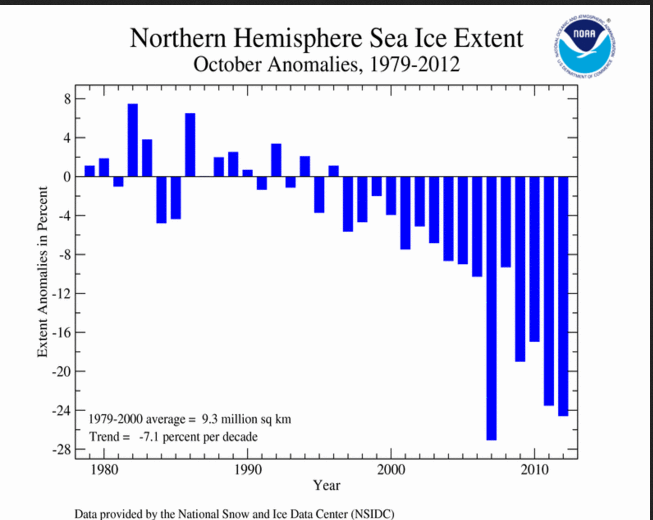
A possible indicator of the warm temperatures  is the extent of sea ice observed over the polar regions in October.

The first graph shows the loss of sea ice over the north polar areas in recent years as measured in October.

While the record is relatively short, the warmth appears to have taken its toll since 2000.

On the other hand the south polar sea ice has actually shown some increase in recent years

With the polar opposite signals, the cause and effect is in question although it appears that the warmth  is well correlated to sea ice loss in the north pole region.


Comparing the daily high/low temperatures with normal and record readings for Jackson WY in October  2012 there were no record setting periods. There was a particularly cold period actually in the first part of October and then ending up well above normal

So far in November after a very warm start, there was a period of below normal temperatures during the second week of the month.  However since then it has been generally mild with above normal temperatures


It now appears after a quick moving system drops a couple inches of snow on Sunday, the remainder of November should be dry and seasonably mild.   The CPC forecast for the coming weekend suggest the mild conditions should extend into the first of December.


Much of the country should experience above normal temperatures through the weekend!

Additionally a moist air mass will spread inland on the West Coast in advance of a major Pacific low pressure trough bringing above normal precipitation into Northern/Central California and Oregon.


Affects from the moist flow could reach into Star Valley over the weekend.

The extended model precipitation forecast covering the period from midnight Wednesday through midnight Sunday shows the potential for a major heavy rain event over Northern California.