Thursday, November 2, 2017

Heavy Snow Expected Western Wyoming Mountains

While heavy snow seems assured in the mountains, Star Valley will 
experience a cold rain changing to snow over the next couple of days.  
At this time, snow on the valley floor appears to be limited to possibly
a couple wet inches by Sunday Morning.

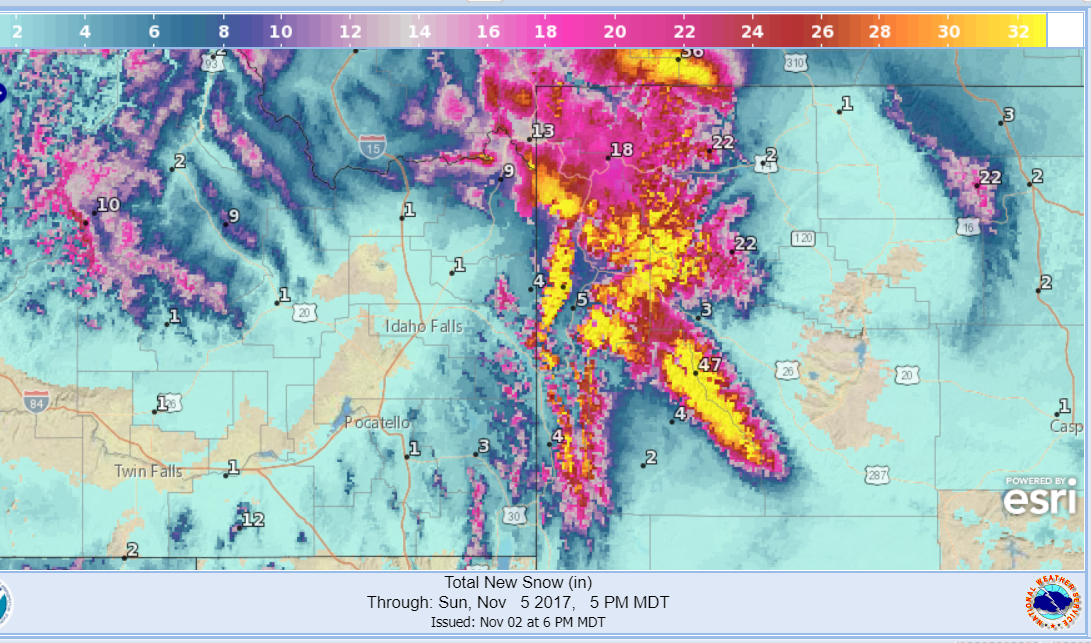
Total snow  by 5pm Sunday Nov. 5 2017


National Weather Service Riverton WY
124 PM MDT Thu Nov 2 2017

...Snow returning to the Western Mountains Friday morning through
Saturday night...

The snowfall that has been falling across much of Northern and
Central Wyoming since Wednesday morning will wind down for most
locations this afternoon...but continue to linger across
northwestern Wyoming.

Then, another more powerful snowstorm is setting up for the
western mountains of Wyoming beginning Friday morning and
continuing through Saturday night. Up to 2 feet or more of
snowfall is expected across much of western/northwestern
mountains by Sunday morning. In addition, gusty southwest winds
could cause blowing and and drifting of snow at times and in
favored locations, making travel difficult or impossible over
some mountains passes, including Teton and Togwotee Passes.


Salt River and Wyoming Ranges-
124 PM MDT Thu Nov 2 2017

...WINTER STORM WARNING IN EFFECT FROM 6 AM MDT FRIDAY TO 5 AM
MST SUNDAY...

* WHAT...Light snow will return to the Salt and Wyoming Mountains
  tonight...with heavy snow and areas of blowing snow expected to
  increase across the area by Friday morning. Plan on difficult
  travel conditions. Total snow accumulations of 10 to 14 inches,
  with localized amounts up to 27 inches, are expected.

* WHERE...Salt River and Wyoming Ranges.

* WHEN...6 AM Friday to 5 AM Sunday.

* ADDITIONAL DETAILS...Winds gusting as high as 40 mph will
  cause areas of blowing and drifting snow.

PRECAUTIONARY/PREPAREDNESS ACTIONS...

A Winter Storm Warning for snow and blowing snow means severe
winter weather conditions are expected. If you must travel, keep
an extra flashlight, food and water in your vehicle in case of an
emergency. The latest road conditions for the state you are
calling from can be obtained by calling 5 1 1.


The National Weather Service is providing increased detailed forecasts 
for any point in the U.S.  The following is a point picked near Thayne
for the next 4 days.

Add caption

First Snows of November, Heavy in the Mountains Coming Friday and Saturday

The first snows of November are expected into this weekend, with the greatest amounts in the higher elevations of Northwest Wyoming.  Total amounts could reach 2-3 feet in the Tetons and possibly several inches in lower populated areas by Saturday night.

Below is a forecast graphic for total expected snowfall up until Saturday evening November 4, 2017. 


There is a Winter Storm Watch for the Mountains adjacent to Star Valley
beginning Friday morning.

Salt River and Wyoming Ranges-
635 AM MDT Thu Nov 2 2017

...WINTER STORM WATCH REMAINS IN EFFECT FROM FRIDAY MORNING
THROUGH SATURDAY EVENING...

* WHAT...Heavy snow and blowing snow possible. 2 to 5 inches
  have fallen so far. Total snow accumulations of 6 to 12
  inches. Plan on difficult travel conditions.

* WHERE...Salt River and Wyoming Ranges.

* WHEN...From Friday morning through Saturday evening.

* ADDITIONAL DETAILS...Winds gusting as high as 40 mph will
  cause areas of blowing and drifting snow.

PRECAUTIONARY/PREPAREDNESS ACTIONS...

A Winter Storm Watch means there is potential for significant
snow, sleet or ice accumulations that may impact travel. Continue
to monitor the latest forecasts.

Saturday, October 28, 2017

What is CoCoRaHS?


There are many thousands of CoCoRaHS observers across the United States.

Plot of CoCoRaHS observations on Oct 27 2017


Active CoCoRaHS observers in Wyoming

What is CoCoRaHS?

CoCoRaHS is an acronym for the Community Collaborative Rain, Hail and Snow Network.  CoCoRaHS is a unique, non-profit, community-based network of volunteers of all ages and backgrounds working together to measure and map precipitation (rain, hail and snow).   By using low-cost measurement tools, stressing training and education, and utilizing an interactive Web-site, our aim is to provide the highest quality data for natural resource, education and research applications. We are now in all fifty states.

Download the updated "CoCoRaHS Brochure" as a PDF (12.4 MB)
CoCoRaHS Wanted Flyer PDF (164 KB)

In northern Lincoln County there are currently about 6 observers that report their precipitation and snow depths every day.  They include

Two in Star Valley Ranch, one each near Thayne, Etna, Afton and Smoot..  While these reports help give some idea of distribution of precipitation across Star Valley, more observations are needed throughout the area to provide a better analysis of rain/snow in the Valley.  Anyone familiar with Star Valley's weather knows there can be big differences over short distances when storms cross the area.


Where did the CoCoRaHS Network originate?

The network originated in the Colorado Climate Center at Colorado State University in 1998, thanks in part to the Fort Collins flood a year prior. In the years since, CoCoRaHS now includes thousands of volunteers nationwide.

Who can participate?

This is a community project.  Everyone can help, young, old, and in-between.  The only requirements are an enthusiasm for watching and reporting weather conditions and a desire to learn more about how weather can affect and impact our lives.

What will our volunteer observers be doing?

Each time a rain, hail or snow storm crosses your area, volunteers take measurements of precipitation from as many locations as possible.  These precipitation reports are then recorded on our Web site www.cocorahs.org. The data are then displayed and organized for many of our end users to analyze and apply to daily situations ranging from water resource analysis and severe storm warnings to neighbors comparing how much rain fell in their backyards.

Water Year 2017 CoCoRaHS plot of Observations at Star Valley Ranch


Who uses CoCoRaHS?
CoCoRaHS is used by a wide variety of organizations and individuals.  The National Weather Service, other meteorologists, hydrologists, emergency managers, city utilities (water supply, water conservation, storm water), insurance adjusters, USDA, engineers, mosquito control, ranchers and farmers, outdoor & recreation interests, teachers, students, and neighbors in the community are just some examples of those who visit our Web site and use our data.

What do we hope to accomplish?

CoCoRaHS has several goals (as stated in our mission statement). 1) provide accurate high-quality precipitation data for our many end users on a timely basis; 2) increasing the density of precipitation data available throughout the country by encouraging volunteer weather observing; 3) encouraging citizens to have fun participating in meteorological science and heightening their awareness about weather; 4) providing enrichment activities in water and weather resources for teachers, educators and the community at large to name a few. 

Who is sponsoring this network?

The National Oceanic and Atmospheric Administration (NOAA) and the National Science Foundation (NSF) are major sponsors of CoCoRaHS. Other organizations have contributed either financially, and/or with supplies and equipment.

What benefits are there in volunteering?

One of the neat things about participating in this network is coming away with the feeling that you have made an important contribution that helps others.  By providing your daily observation, you help to fill in a piece of the weather puzzle that affects many across your area in one way or another. You also will have the chance to make some new friends as you do something important and learn some new things along the way. In some areas, activities are organized for network participants including training sessions, field trips, special speakers, picnics, pot-luck dinners, and photography contests just to name a few.

How can I sign up?

Just click here to sign up as a CoCoRaHS Volunteer Observer or download a .pdf version of our application and return it as soon as possible.

Wednesday, October 25, 2017

Reservoir Storage Going into the Winter Snow Season

Wyoming will be entering the 2017-2018 snow season with a very healthy carry over water supply in the reservoir systems thanks to last seasons big runoff.  Following is the status of Wyoming reservoirs as of late October showing the percentage of the capacity of each.


With the exception of the southeast, Wyoming Reservoirs are going into the winter snow season with very healthy levels.  It is interesting to note that both Lake Powell and Lake Mead still reflect the long term drought with (60% and 38%) respectively.

However the Snake River Reservoir System which includes much of northwestern Wyoming is holding very high amounts of water.


For Water Year 2018 which we are now beginning as of Oct 1st, the reservoir system is holding nearly 3 times the amount of water as last year at the same time and almost double normal.

Specfically, Palisades Reservoir noted in the figure below, still is over 90%  full. This is 10 times what it was a year
ago and close to double  the amount normally being stored..

It will be interesting to monitor what effects this coming Winter snows  and Spring runoff will have on water levels, particularly in Palisades which is still nearly full.


Riverton Weather Forecast Office History

Forecaster Work Station
The Forecast for Star Valley is produced at the Riverton Forecast Office.  A new forecast is displayed on the Starvalleyweather.com site whenever changes occur.  Riverton is one of some 122 Weather Forecast Offices in the United States. The Pocatello Forecast Office provides for the Idaho Counties and this will sometime account for the differences in forecast for the Idaho vs Wyoming Counties.

Riverton Weather Forecast Office

Riverton Weather Office History

In 1986 the NWS announced a modernization and restructuring program designed to revamp the organizational and staffing structure of the agency. In April of that year Riverton was selected as the site for a proposed NEXRAD (Next Generation Radar) Doppler radar and forecast office. 
Construction of the office facility was completed in March 1995. The installation of the radar soon followed in June and July.  WFO operations began in Riverton on August 28, 1995 with a staff of 18. The radar was formally accepted on April 10, 1996. 
Beginning in 1996 the Riverton WFO took warning responsibility for eleven counties in western and central Wyoming comprising over 56,000 square miles. These counties remain the same today and include Big Horn, Fremont, Hot Springs, Johnson, Lincoln, Natrona, Park, Sublette, Sweetwater, Teton, and Washakie.  The arrival of the Advanced Weather Interactive Processing System (AWIPS) in April 1999 dramatically altered the computer capabilities of the WFO.  AWIPS remains the main computer interface for WFO meteorologists, but upgrades to the operating system and accompanying software occur frequently to keep up with changing technologies. The arrival of the AWIPS also ushered in five new lead forecasters to serve at the WFO. This brought the level of staffing to 23, where it remains today.
The era of typed forecasts came to an end in October, 2002 with the first issuance of a digital database of weather information. Today, the Graphical Forecast Editor (GFE) is used to create a suite of digital weather elements which in turn generate various types of forecasts for users across western and central Wyoming, most commonly the seven-day public forecast and fire weather forecast. 
Today, the 23 professionals at the Riverton WFO remain dedicated to providing the best possible weather forecasts, warnings, hydrologic, and climate information available to the citizens of western and central Wyoming. In addition to the day-to-day weather forecasting, the employees maintain and repair weather observing systems across the service area, create and install new computer software, conduct scientific research, and routinely interface with customers and the public. All are encouraged  to stop by and visit the forecast office on U.S. Highway 26 about five miles west of Riverton.

Thursday, October 19, 2017

U.S Winter Outlook Issued

While the New Winter Outlook is calling for somewhat above normal precipitation for Star Valley along with a little warmer than average temperatures we know it will snow. The statement at the end of the article is worth repeating.

NOAA’s seasonal outlooks give the likelihood that temperature and precipitation will be above-, near, or below-average, and also how drought is expected to change, but do not project seasonal snowfall accumulations. While the last two winters featured above-average temperatures over much of the nation, significant snowstorms still impacted different parts of the country.
Snow forecasts are generally not predictable more than a week in advance because they depend upon the strength and track of winter storms.
The U.S. Winter Outlook will be updated on November 16.
 NOAA’s Climate Prediction Center released the U.S. Winter Outlook,  with La Nina potentially emerging for the second year in a row as the biggest wildcard in how this year’s winter will shape up. La Nina has a 55- to 65-percent chance of developing before winter sets in.


NOAA produces seasonal outlooks to help communities prepare for what's likely to come in the next few months and minimize weather's impacts on lives and livelihoods. Empowering people with actionable forecasts and winter weather tips is key to NOAA’s effort to build a Weather-Ready Nation.
“If La Nina conditions develop, we predict it will be weak and potentially short-lived, but it could still shape the character of the upcoming winter,” said Mike Halpert, deputy director of NOAA’s Climate Prediction Center. “Typical La Nina patterns during winter include above average precipitation and colder than average temperatures along the Northern Tier of the U.S. and below normal precipitation and drier conditions across the South.”
Other factors that influence winter weather include the Arctic Oscillation, which influences the number of arctic air masses that penetrate into the South and is difficult to predict more than one to two weeks in advance, and the Madden-Julian Oscillation, which can affect the number of heavy rain events along the West Coast.
The 2017 U.S. Winter Outlook (December through February):
Precipitation
  • Wetter-than-average conditions are favored across most of the northern United States, extending from the northern Rockies, to the eastern Great Lakes, the Ohio Valley, in Hawaii and in western and northern Alaska.
  • Drier-than-normal conditions are most likely across the entire southern U.S.

Temperature
  • Warmer-than-normal conditions are most likely across the southern two-thirds of the continental U.S., along the East Coast, across Hawaii and in western and northern Alaska.
  • Below-average temperatures are favored along the Northern Tier of the country from Minnesota to the Pacific Northwest and in southeastern Alaska.
  • The rest of the country falls into the equal chance category, which means they have an equal chance for above-, near-, or below-normal temperatures and/or precipitation because there is not a strong enough climate signal in these areas to shift the odds.
  • NOAA’s seasonal outlooks give the likelihood that temperature and precipitation will be above-, near, or below-average, and also how drought is expected to change, but do not project seasonal snowfall accumulations. While the last two winters featured above-average temperatures over much of the nation, significant snowstorms still impacted different parts of the country. Snow forecasts are generally not predictable more than a week in advance because they depend upon the strength and track of winter storms. The U.S. Winter Outlook will be updated on November 16.


Saturday, October 14, 2017

Preliminary Snowfall Totals Through Noon Saturday


3 Inches at Star Valley Ranch  Friday Night

Public Information Statement
National Weather Service Riverton WY
200 PM MST Sat Oct 14 2017

...Preliminary Snowfall Totals Through Noon Saturday..

Snowfall began in western Wyoming late Friday night and began to
spread east of the Divide during the predawn hours Saturday. The
snow is tapering off now and will soon end across the state. A
relatively narrow band of persistent heavy snow passed over Teton
Pass to Teton Village area where and estimated 4 to 10 inches of
snow accumulated.

Snotels (Snow Telemetry) are remote sensing sites in the mountain
watersheds.  Snowfall data from SNOTELS are estimated based on snow
water equivalent.
Location                              Snowfall
Lincoln County...
 Willow Creek Snotel...               4 inches.
 5 NNE Thayne...                    3.5 inches.
 Cottonwood Creek Snotel...           3 inches.
 Commissary Ridge...                  3 inches.
 Star Valley Ranch...                 3 inches.
 Box Y Ranch...                       2 inches.
 Spring Creek Divide Snotel...        2 inches.
 Indian Creek Snotel...               2 inches.
 Blind Bull Summit...                 2 inches.
 Afton...                           1.5 inches.
 5 SSE Smoot...                       1 inch.
 Salt River Summit Snotel...          1 inch.
 Kelley Ranger Station Snotel...      1 inch.
 2 SE Thayne...                       1 inch.
Big Horn County... Shell Creek Snotel... 2 inches. Bald Mountain Snotel... 1 inch. Fremont County... St. Lawrence Alt Snotel... 6 inches. Hobbs Park Snotel... 6 inches. Dubois... 5 inches. Hudson... 3.5 inches. Townsend Creek Snotel... 3 inches. Lander Airport... 2.6 inches. Brooks Lake... 2 inches. Riverton Airport... 1.9 inches. 4 W Riverton... 1.5 inches. 7 WNW Lander... 1.1 inches. Little Warm Snotel... 1 inch. Deer Park Snotel... 1 inch. Castle Creek Snotel... 1 inch. Riverton... 0.2 inches. Burris... 0.1 inches. Hot Springs County... Owl Creek Snotel... 3 inches. Thermopolis... 0.2 inches. Johnson County... Cloud Peak Reservoir Snotel... 2 inches. Bear Trap Meadow Snotel... 1 inch. Natrona County... Grave Springs Snotel... 2 inches. Reno Hill Snotel... 1 inch. Casper Airport... 0.2 inches. Park County... Beartooth Lake Snotel... 7 inches. Blackwater Snotel... 4 inches. Evening Star Snotel... 3 inches. Kirwin Snotel... 3 inches. Timber Creek Snotel... 2 inches. Marquette Snotel... 2 inches. Pahaska... 1 inch. Wolverine Snotel... 1 inch. Younts Peak Snotel... 1 inch. 3 NE Sunshine... 0.9 inches. 26 SW Cody... 0.5 inches. Sublette County... Pocket Creek Snotel... 6 inches. Boulder Rearing Station... 3 inches. Snider Basin Snotel... 2 inches. Big Sandy Opening Snotel... 1 inch. Gunsite Pass Snotel... 1 inch. East Rim Divide Snotel... 1 inch. 14 NW Pinedale... 0.8 inches. Daniel Fish Hatchery... 0.1 inches. Sweetwater County... Teton County... Jackson Hole - Rendezvous Bowl... 11 inches. Jackson Hole - Raymer... 9 inches. Jackson Hole - Mid Mountain... 9 inches. Grand Targhee - Chief Joseph... 8 inches. Togwotee Pass Snotel... 8 inches. Jackson Hole - Base... 8 inches. 2 NE Teton Village... 7 inches. 5 NW Jackson... 7 inches. Grand Targhee Snotel... 6 inches. Snow King... 5 inches. Jackson... 2 to 4 inches. Base Camp Snotel... 3 inches. Jackson Dam... 3 inches. Togwotee Mountain Lodge... 3 inches. Grassy Lake Snotel... 2 inches. Snake River Stn Snotel... 1 inch. Washakie County... Powder River Pass Snotel... 3 inches. 16 SSE Ten Sleep... 0.5 inches. Yellowstone National Park... Sylvan Lake Snotel... 6 inches. Lewis Lake Divide Snotel... 5 inches. Parker Peak Snotel... 5 inches. Two Ocean Plateau Snotel... 3 inches. Canyon Snotel... 2 inches. Yellowstone East Entrance... 2 inches. Sylvan Road Snotel... 1 inch. Thumb Divide Snotel... 1 inch.