The web cam located at Star Valley Ranch captured some impressive and rapid development of cumulonimbus over the mountains to the west of Star Valley. The storm formed and then dissipated just as fast.
Time Lapse of Cumulonimbus
Saturday, June 29, 2013


Friday, June 28, 2013
Wyoming Video Weather Briefing
Following is the link to the weekly Wyoming Weather Briefing provided by the Riverton WFO
Wyoming Weather Briefing
Wyoming Weather Briefing
Wednesday, June 26, 2013
Potentially Deadly Heat Wave Arizona, Nevada and California Deserts This Weekend
For those who live, or are in Star Valley currently, we can be thankful. It is going to be a very hot several days in the desert valleys of the Southwest. The culprit is an unusually large upper high pressure system that will develop by the end of this week. Following are two 500mb charts that provide the explanation of the impending heat wave. The first is this Wednesday morning, June 26th and then for mid day Saturday June29th.


This large upper high will provide ideal conditions for maximum heating, clear skies, warm very and dry subsiding air along with near maximum daylight hours.
Here are forecasts for major desert metropolitan areas through the coming weekend.


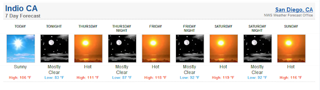

The Phoenix WFO has a Video web briefing that summarizes the upcoming heat wave and precautions that should be taken.
Web Briefing on Upcoming Heat Wave
This heat wave is coming up on the 100th Anniversary of the All-Time hottest temperature ever recorded on the Earth in Death Valley of 134 degrees. The official Death Valley weather station at Furnace Creek is forecast to reach within several degrees of that record by this weekend.

For real weather junkies there is a ceremony that will be held at Furnace Creek on the Anniversary of the record. Following is the information for those who would like to attend!


This large upper high will provide ideal conditions for maximum heating, clear skies, warm very and dry subsiding air along with near maximum daylight hours.
Here are forecasts for major desert metropolitan areas through the coming weekend.


The Phoenix WFO has a Video web briefing that summarizes the upcoming heat wave and precautions that should be taken.
Web Briefing on Upcoming Heat Wave
This heat wave is coming up on the 100th Anniversary of the All-Time hottest temperature ever recorded on the Earth in Death Valley of 134 degrees. The official Death Valley weather station at Furnace Creek is forecast to reach within several degrees of that record by this weekend.

For real weather junkies there is a ceremony that will be held at Furnace Creek on the Anniversary of the record. Following is the information for those who would like to attend!

Friday, June 21, 2013
Weekly Weather Briefing from Riverton WFO
The following is the link to the Weekly weather briefing issued by the Riverton WFO
Riverton WFO weekly weather briefing
Riverton WFO weekly weather briefing
Star Valley Summer Will Start Next Week
Following is the graph from the Thayne ES weather station for the past 30 days.
 |
| Thayne ES max/min temperatures May 20-June 20 2013 |
Following is the Weather Table for the Month of June at Thayne ES thus far

Noticeably is the the lack of any appreciable precipitation so far this June.
The current cool weather is the result of an upper trough of low pressure over the Northwest U.S.
 |
| 500 MB Analysis midnight Thursday June 20 2013 |
This pattern will change over this next week leading to a large high pressure over the Western States.
 |
| 500 MB forecast midnight Tuesday June 25 2013 |
 |
| 500 MB forecast midnight Friday June 28 2013 Reflecting this forecast the 6-10 temperature forecast for the end of next week through the weekend calls for very warm conditions in the mountain west  For the same time period the CPC is indicating that precipitation could be returning to the region.  |
This could reflect the beginning of the Southwestern Monsoon. So there is some hope of June ending on a wetter note, even with temperatures likely reaching into the upper 80s and low 90s by the end of next week.
Tuesday, June 18, 2013
Supercell Thunderstorm Visits the Tetons
Supercell Thunderstorm visits the Tetons.
Late afternoon on June 12, 2013 a Supercell Thunderstorm developed over the upper Snake River Valley of Eastern Idaho and rapidly moved east across the Tetons and the Jackson Hole region. Though no tornados were reported(and likely did not develop) this storm was a classic Supercell as seen both through the photographs taken and the radar signatures. Jim Woodmencey(Woody) of Mountainweather.com has provided a couple excellent blogs on his web site with the photographs and other interesting meteorological observations associated with the Supercell. The photo of the day was taken from Snow King looking west at the approaching storm

Here is a link to Woody's blog concerning the storm. Be sure to check out the blogs on both June 12th and 17th.
MountainWeather Blog
Thanks Woody
Friday, June 14, 2013
Freezing Temperatures Saturday Morning
A strong cold front moved across Star Valley Thursday evening, and in its wake a much cooler air mass now covers Western Wyoming. High pressure now building into the area assures several near perfect weather days ahead.
However, conditions tonight and Saturday morning will be ideal for strong radiational cooling, leading to frost most areas Saturday morning. Temperatures in the typical colder valley locations primarily near the Salt River will likely drop below freezing by midnight, Friday night and possibly bottoming out in the mid to upper 20s by daybreak Saturday.
Obviously this is a threat to frost sensitive vegetables that may have just been planted such as tomatoes etc. These plants should be covered tonight.
Warming is then expected through the Fathers Day weekend, with a lessening frost threat Sunday morning.
Subscribe to:
Posts (Atom)