URGENT - WINTER WEATHER MESSAGE
NATIONAL WEATHER SERVICE RIVERTON WY
937 PM MST SUN JAN 4 2015

...POTENT PROLONGED WINTER STORM FOR THE WESTERN AND NORTHERN
MOUNTAINS...

.LIGHT SNOW WILL BE REPLACED BY MODERATE TO HEAVY SNOW LATER
TONIGHT ACROSS THE WESTERN AND NORTHERN MOUNTAINS ALONG WITH
STRONG WEST TO NORTHWEST WINDS OF 30 TO 40 MPH AT MOUNTAIN TOP
LEVEL. A PROLONGED PERIOD OF STRONG WINDS AND DEEP PACIFIC
MOISTURE PRODUCING PERIODS OF MODERATE TO HEAVY SNOW AND
SIGNIFICANT BLOWING SNOW WILL INCREASE LATER TONIGHT...AND
CONTINUE THROUGH MONDAY AND MONDAY NIGHT...MAKING FOR VERY
HAZARDOUS TRAVEL CONDITIONS.

WYZ023-024-051245-
/O.CON.KRIW.WS.W.0001.000000T0000Z-150106T1200Z/
STAR VALLEY-SALT RIVER AND WYOMING RANGES-
INCLUDING THE CITIES OF...AFTON...ALPINE...STAR VALLEY RANCH...
THAYNE
937 PM MST SUN JAN 4 2015

...WINTER STORM WARNING REMAINS IN EFFECT UNTIL 5 AM MST
TUESDAY...

* SUMMARY AND TIMING...LIGHT TO MODERATE SNOW TODAY...WITH GENERAL
  24 HOUR ACCUMULATIONS OF BETWEEN 3 AND 5 INCHES IN THE
  MOUNTAINS...WILL BE REPLACED BY PERIODS OF HEAVY SNOW AND
  INCREASED WINDS LATER TONIGHT...LASTING THROUGH MONDAY NIGHT.

* SNOW ACCUMULATIONS...15 TO 30 INCHES THE MOUNTAINS WITH 10 TO
  20 INCHES IN THE STAR VALLEY. LOCALLY HIGHER AMOUNTS WILL BE
  POSSIBLE.

* WIND AND VISIBILITY...ABOVE 8000 FEET...WEST TO SOUTHWEST
  WINDS 15 TO 30 MPH WITH GUSTS 40 TO 50 MPH WILL COMBINE WITH
  THE SNOW...GREATLY REDUCING VISIBILITY AT TIMES.

* IMPACTS...ROADS WILL BE SLICK...SNOWPACKED...WITH POSSIBLE
  LARGE DRIFTS COVERING THE ROADWAYS AT TIMES...MAKING TRAVEL
  EXTREMELY HAZARDOUS...ESPECIALLY ON SALT RIVER PASS.

PRECAUTIONARY/PREPAREDNESS ACTIONS...

REMEMBER...A WINTER STORM WATCH MEANS CONDITIONS ARE FAVORABLE
FOR HAZARDOUS WINTER WEATHER IN AND CLOSE TO THE WATCH AREA.

A WINTER STORM WARNING FOR HEAVY SNOW MEANS SEVERE WINTER WEATHER
CONDITIONS ARE EXPECTED OR OCCURRING.  SIGNIFICANT AMOUNTS OF
SNOW ARE FORECAST THAT WILL MAKE TRAVEL DANGEROUS. ONLY TRAVEL IN
AN EMERGENCY. IF YOU MUST TRAVEL...KEEP AN EXTRA FLASHLIGHT...
FOOD...AND WATER IN YOUR VEHICLE IN CASE OF AN EMERGENCY.

THE LATEST ROAD CONDITIONS PROVIDED BY THE WYOMING DEPARTMENT OF
TRANSPORTATION ARE AVAILABLE BY CALLING 5-1-1 OR ON THE INTERNET
AT WYOROAD.INFO.
Sunday, January 4, 2015
Updated-Winter Storm Warning Star Valley


WINTER STORM WARNING STAR VALLEY
URGENT - WINTER WEATHER MESSAGE
NATIONAL WEATHER SERVICE RIVERTON WY
137 AM MST SUN JAN 4 2015
...POTENT WINTER STORM SYSTEM TO ARRIVE TONIGHT...

.LIGHT TO OCCASIONALLY MODERATE SNOW WILL BEGIN TO FALL ACROSS
THE WESTERN AND NORTHWESTERN MOUNTAINS THIS MORNING...AHEAD OF A
MUCH STRONGER UPPER LEVEL DISTURBANCE AND GREATLY INCREASED
MOISTURE FROM THE PACIFIC NORTHWEST WHICH WILL ARRIVE OVERNIGHT
TONIGHT. SNOWFALL INTENSITY WILL RAPIDLY INCREASE ALONG WITH
STRONG WESTERLY WINDS AT THIS TIME...PRODUCING AREAS OF HEAVY
BLOWING AND DRIFTING SNOW AND GREATLY REDUCED VISIBILITIES THROUGH
TUESDAY MORNING...MAKING FOR VERY HAZARDOUS TRAVEL CONDITIONS.

WYZ001-012-013-023-024-042300-
/O.UPG.KRIW.WS.A.0001.150105T0000Z-150106T1200Z/
/O.NEW.KRIW.WS.W.0001.150105T0000Z-150106T1200Z/
YELLOWSTONE NATIONAL PARK-TETON AND GROS VENTRE MOUNTAINS-
JACKSON HOLE-STAR VALLEY-SALT RIVER AND WYOMING RANGES-
INCLUDING THE CITIES OF...LAKE...MAMMOTH...OLD FAITHFUL...
JACKSON...AFTON...ALPINE...STAR VALLEY RANCH...THAYNE
137 AM MST SUN JAN 4 2015

...WINTER STORM WARNING IN EFFECT FROM 5 PM THIS AFTERNOON TO
5 AM MST TUESDAY...

THE NATIONAL WEATHER SERVICE IN RIVERTON HAS ISSUED A WINTER
STORM WARNING FOR HEAVY SNOW AND BLOWING SNOW...WHICH IS IN EFFECT
FROM 5 PM THIS AFTERNOON TO 5 AM MST TUESDAY. THE WINTER STORM
WATCH IS NO LONGER IN EFFECT.

* SUMMARY AND TIMING...LIGHT TO MODERATE SNOW TODAY WILL BE
  REPLACED BY PERIODS OF HEAVY SNOW AND INCREASED WINDS BEGINNING
  TONIGHT...LASTING THROUGH TUESDAY MORNING.

* SNOW ACCUMULATIONS...ONE TO TWO FEET IN THE MOUNTAINS WITH 6
  TO 12 INCHES IN THE JACKSON AND STAR VALLEYS. LOCALLY HIGHER
  AMOUNTS WILL BE POSSIBLE.

* WIND AND VISIBILITY...ABOVE 8500 FEET...WEST TO SOUTHWEST WINDS
  15 TO 30 MPH WITH GUSTS 40 TO 50 MPH WILL COMBINE WITH THE SNOW...GREATLY
  REDUCING VISIBILITY AT TIMES.

* IMPACTS...ROADS WILL BE SLICK...SNOWPACKED...WITH POSSIBLE
  LARGE DRIFTS COVERING THE ROADWAYS AT TIMES...MAKING TRAVEL
  EXTREMELY HAZARDOUS.

PRECAUTIONARY/PREPAREDNESS ACTIONS...

REMEMBER...A WINTER STORM WATCH MEANS CONDITIONS ARE FAVORABLE
FOR HAZARDOUS WINTER WEATHER IN AND CLOSE TO THE WATCH AREA.

A WINTER STORM WARNING FOR HEAVY SNOW MEANS SEVERE WINTER WEATHER
CONDITIONS ARE EXPECTED OR OCCURRING.  SIGNIFICANT AMOUNTS OF
SNOW ARE FORECAST THAT WILL MAKE TRAVEL DANGEROUS. ONLY TRAVEL IN
AN EMERGENCY. IF YOU MUST TRAVEL...KEEP AN EXTRA FLASHLIGHT...
FOOD...AND WATER IN YOUR VEHICLE IN CASE OF AN EMERGENCY.

THE LATEST ROAD CONDITIONS PROVIDED BY THE WYOMING DEPARTMENT OF
TRANSPORTATION ARE AVAILABLE BY CALLING 5-1-1 OR ON THE INTERNET
AT WYOROAD.INFO.
Saturday, January 3, 2015
First Snowstorm of 2015 On The Way
URGENT - WINTER WEATHER MESSAGE
NATIONAL WEATHER SERVICE RIVERTON WY
120 AM MST SAT JAN 3 2015

...POTENT WINTER STORM SYSTEM TO ARRIVE SUNDAY NIGHT...

.AFTER A SHORT BREAK FROM SNOW TONIGHT...LIGHT TO OCCASIONALLY
MODERATE SNOW WILL BEGIN TO FALL ACROSS THE WESTERN AND
NORTHWESTERN MOUNTAINS ONCE AGAIN BY SUNDAY MORNING...AHEAD OF A
MUCH STRONGER UPPER LEVEL DISTURBANCE AND GREATLY INCREASED
MOISTURE FROM THE PACIFIC NORTHWEST. DURING THE OVERNIGHT PERIOD
ON SUNDAY...SNOWFALL INTENSITY WILL RAPIDLY INCREASE ALONG WITH
STRONG WESTERLY WINDS. THIS WILL PRODUCE AREAS OF HEAVY BLOWING
AND DRIFTING SNOW AND GREATLY REDUCED VISIBILITIES THROUGH TUESDAY
MORNING...MAKING FOR VERY HAZARDOUS TRAVEL CONDITIONS.

WYZ001-012-013-023-024-032300-
/O.NEW.KRIW.WS.A.0001.150105T0000Z-150106T1200Z/
YELLOWSTONE NATIONAL PARK-TETON AND GROS VENTRE MOUNTAINS-
JACKSON HOLE-STAR VALLEY-SALT RIVER AND WYOMING RANGES-
INCLUDING THE CITIES OF...LAKE...MAMMOTH...OLD FAITHFUL...
JACKSON...AFTON...ALPINE...STAR VALLEY RANCH...THAYNE
120 AM MST SAT JAN 3 2015

...WINTER STORM WATCH IN EFFECT FROM SUNDAY AFTERNOON THROUGH
LATE MONDAY NIGHT...

THE NATIONAL WEATHER SERVICE IN RIVERTON HAS ISSUED A WINTER
STORM WATCH...WHICH IS IN EFFECT FROM SUNDAY AFTERNOON THROUGH
LATE MONDAY NIGHT.

* SUMMARY AND TIMING...PERIODS OF MODERATE TO HEAVY SNOW AND
  INCREASED WINDS TO BEGIN SUNDAY NIGHT...LASTING THROUGH TUESDAY
  MORNING.

* SNOW ACCUMULATIONS...ONE TO TWO FEET IN THE MOUNTAINS WITH 6 TO
  12 INCHES IN THE JACKSON AND STAR VALLEYS. LOCALLY HIGHER
  AMOUNTS WILL BE POSSIBLE.

* WIND AND VISIBILITY...WEST TO SOUTHWEST WINDS 15 TO 30 MPH WITH
  GUSTS 40 TO 50 MPH WILL COMBINE WITH THE SNOW...GREATLY REDUCING VISIBILITY
  AT TIMES.

* IMPACTS...ROADS WILL BE SLICK...SNOWPACKED...WITH POSSIBLE LARGE
  DRIFTS COVERING THE ROADWAYS AT TIMES...MAKING TRAVEL EXTREMELY
  HAZARDOUS.

PRECAUTIONARY/PREPAREDNESS ACTIONS...

REMEMBER...A WINTER STORM WATCH MEANS CONDITIONS ARE FAVORABLE
FOR HAZARDOUS WINTER WEATHER IN AND CLOSE TO THE WATCH AREA.

THE LATEST ROAD CONDITIONS PROVIDED BY THE WYOMING DEPARTMENT OF
TRANSPORTATION ARE AVAILABLE BY CALLING 5-1-1 OR ON THE INTERNET
AT WYOROAD.INFO.
Thursday, January 1, 2015
Weather Video 1st week of 2015
Riverton Forecast Office has posted their weekly video providing hope for relief from the current cold temperatures.
Weekly Weather Briefing Video
Weekly Weather Briefing Video
Cliff Mass, meteorology professor at the University of Washington makes a case for the amazing improvements of weather forecasts in recent history.

Is Numerical Weather Prediction One of Mankind's Greatest Achievements?
Mankind has achieved some marvels during the past several thousand years, from landing on the moon and the construction of the pyramids to modern computers and genetic engineering. But perhaps weather prediction, and particularly numerical weather prediction, deserves to be in the Pantheon of the highest achievements of our species, and this blog will explain why.
Modern weather prediction is perhaps the most cooperative activity of our species. To forecast the weather anywhere on the globe require weather data everywhere on the globe. A disturbance over China today, can be over the U.S. in a few days, and vice versa. Even during the cold war we shared data with China and the Soviet Union. Nearly every nation exchanges its weather data with others, with few exceptions (like North Korea).

Modern weather prediction requires the ability to simulate atmospheric effects on a vast range of scales ranging from the molecular to the planetary. To predict the weather one must deal with the condensation of water vapor on microscopic particles less than a micron (millionth of a meter) in size on one hand to planetary circulations of many thousands of kilometers on the other.
Modern weather prediction uses the world's most powerful computers and the associated model software includes millions of lines of code. Some of the biggest computers in the world are used for weather/climate simulation. For example, the UK Meteorology Office just purchased a 16 petaflop computer from CRAY (a petaflop is a thousand trillion operations per second).

The number of lives saved and the economic value of weather prediction is beyond measure. Superstorm Sandy hit the NY Metro area, home of tens of millions of people, with hurricane-force winds and major coastal flooding. Roughly 150 lost their lives and many of them did so because they ignored the forecasts. A similar storm hit a far more sparsely populated area of eastern Long Island in 1938 and over a thousand people perished. In 1900, a hurricane hit Galveston Texas and 6000 people died. Weather prediction is now an essential tool for farmers and for those that manage our dams and roads, to mention only a few applications. And if the weather becomes more extreme under global warming, improved weather prediction will play a large role in protecting life and property.
The amount of data collected for operational numerical weather prediction is staggering. Petabytes of weather data are streaming to earth from dozens of weather satellites each day. Hundreds of thousands of surface stations, roughly a thousand radiosondes, thousands of ships and buoys, thousands of aircraft, lightning detection networks, and other sensors are reporting each day, adding up to tens to hundreds terabytes of information daily. All this data is distributed around the world, quality controlled, and used to provide a physically consistent description of the three-dimensional atmosphere.
.jpeg)
Modern numerical forecasting went from non-existent in 1950 to highly skillful today. The following chart is my favorite. It shows increasing skill at 3, 5, 7, and 10 days at 500 hPa (about 18,000 ft) at one major forecasting center (the European Center, ECMWF). Major increases in skill at each time projection (up is better). But even more impressive is the fact that southern hemisphere forecast skill (the lower lines for each color band) now equals to the northern (which has much surface and upper air observations). The major reason: weather satellites

So during this end-of-year season it is good to reflect on how far we have come in weather prediction, even though we have the potential to push the science and technology much further. And we should not forget the dedicated folks that developed the models, the scientists/engineers that designed the satellites and observing systems, and the human forecasters that interpret and communicate the model output. A huge and expensive enterprise that is worth the investment. And one that has been been a successful partnership between the government and private sectors.
The media spends so much time highlighting what is wrong with society. But sometime we should think about our great positive achievements, particularly those dependent on the active positive cooperation of mankind. Weather prediction surely is one of them.
Landing a man on the moon, was in many ways, a less impressive
achievement than modern weather prediction.
Modern weather prediction is perhaps the most cooperative activity of our species. To forecast the weather anywhere on the globe require weather data everywhere on the globe. A disturbance over China today, can be over the U.S. in a few days, and vice versa. Even during the cold war we shared data with China and the Soviet Union. Nearly every nation exchanges its weather data with others, with few exceptions (like North Korea).
Modern weather prediction requires the ability to simulate atmospheric effects on a vast range of scales ranging from the molecular to the planetary. To predict the weather one must deal with the condensation of water vapor on microscopic particles less than a micron (millionth of a meter) in size on one hand to planetary circulations of many thousands of kilometers on the other.
Modern weather prediction uses the world's most powerful computers and the associated model software includes millions of lines of code. Some of the biggest computers in the world are used for weather/climate simulation. For example, the UK Meteorology Office just purchased a 16 petaflop computer from CRAY (a petaflop is a thousand trillion operations per second).
Seattle's CRAY Supercomputers have become the hardware of choice for leading numerical weather prediction efforts
The number of lives saved and the economic value of weather prediction is beyond measure. Superstorm Sandy hit the NY Metro area, home of tens of millions of people, with hurricane-force winds and major coastal flooding. Roughly 150 lost their lives and many of them did so because they ignored the forecasts. A similar storm hit a far more sparsely populated area of eastern Long Island in 1938 and over a thousand people perished. In 1900, a hurricane hit Galveston Texas and 6000 people died. Weather prediction is now an essential tool for farmers and for those that manage our dams and roads, to mention only a few applications. And if the weather becomes more extreme under global warming, improved weather prediction will play a large role in protecting life and property.
The amount of data collected for operational numerical weather prediction is staggering. Petabytes of weather data are streaming to earth from dozens of weather satellites each day. Hundreds of thousands of surface stations, roughly a thousand radiosondes, thousands of ships and buoys, thousands of aircraft, lightning detection networks, and other sensors are reporting each day, adding up to tens to hundreds terabytes of information daily. All this data is distributed around the world, quality controlled, and used to provide a physically consistent description of the three-dimensional atmosphere.
A NOAA Polar Orbiter Weather Satellite
Modern numerical forecasting went from non-existent in 1950 to highly skillful today. The following chart is my favorite. It shows increasing skill at 3, 5, 7, and 10 days at 500 hPa (about 18,000 ft) at one major forecasting center (the European Center, ECMWF). Major increases in skill at each time projection (up is better). But even more impressive is the fact that southern hemisphere forecast skill (the lower lines for each color band) now equals to the northern (which has much surface and upper air observations). The major reason: weather satellites
So during this end-of-year season it is good to reflect on how far we have come in weather prediction, even though we have the potential to push the science and technology much further. And we should not forget the dedicated folks that developed the models, the scientists/engineers that designed the satellites and observing systems, and the human forecasters that interpret and communicate the model output. A huge and expensive enterprise that is worth the investment. And one that has been been a successful partnership between the government and private sectors.
The media spends so much time highlighting what is wrong with society. But sometime we should think about our great positive achievements, particularly those dependent on the active positive cooperation of mankind. Weather prediction surely is one of them.
2014 Lower Valley Weather Summaries
Following are the Weather Station summaries for Thayne Elementary School, Etna Elementary School and the Town of Star Valley Ranch for the year 2014.
Note that the 171 MPH wind on April 18th is an error.
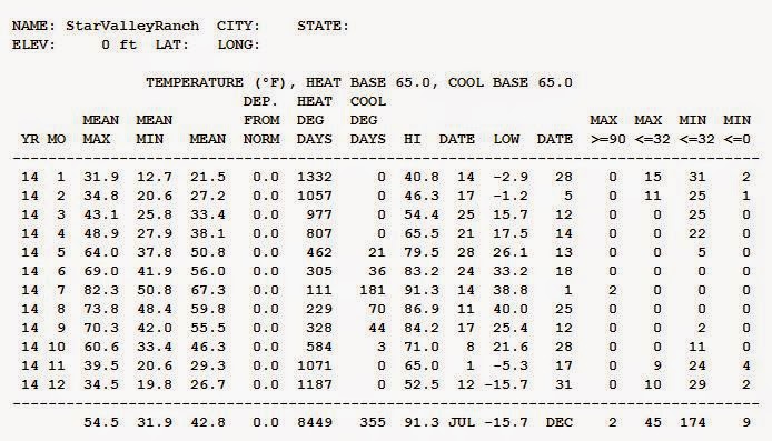 |
| Star Valley Ranch 2014 |
 |
| Star Valley Ranch Wind 2014 |
 |
| Thayne ES 2014 |
 |
| Thayne ES Wind 2014 |
 |
| Etna ES 2014 |
 |
| Etna ES Wind 2014 |
2014 Ends With Extreme Cold


2014 Ends with Extreme Cold
It was a chilly Tuesday night (Dec 30 - Dec 31) with extreme cold temperatures felt across western & central Wyoming. The cooperative site at Daniel in the Upper Green River Basin bottomed out at 48 below zero. Below is a quick summary of the lows that occurred Tuesday night.
 |
 |
| A complete listing of lows for December 31st. |
Subscribe to:
Posts (Atom)