Thursday, October 18, 2012

SNOW ON THE WAY

The first significant fall precipitation event across Star Valley occurred on Tuesday. It provided  amounts ranging from 1/4 to over 1/2 inch.  Here are some observed totals.

2 NW of Etna       .80
Afton                   .58
Smoot                  .49
Thayne ES           .36
Alpine                  .32
Etna ES                .30
Star Valley Ranch  .22

Below is a precipitation map covering the surrounding regions from the recent storm


Over an inch occurred in the mountains north of Star Valley, particularly the Tetons.

For much of the event the snow level was above about 8500 feet.

A cam photo taken Wednesday afternoon shows the fresh snow on the Tetons.


The computer models have been quite erratic in forecasting what now appears to be a major pattern change coming this weekend.  However the Wednesday evening model solutions are generally agreeing that the large upper ridge now over the western states will be replaced be a strong and cold upper low pressure trough forming this weekend off the West Coast and then slowly moving eastward toward Star Valley next week.

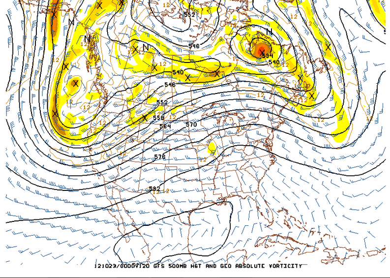
Here is the 500 mb chart observed this Wednesday evening showing the deep low over the Central states and high pressure along the West Coast.


500MB Analysis Wednesday evening 10/17/12
Following are the forecasted 500MB charts for both this Saturday evening and Monday evening.

 The deep central states trough moves east with the upper ridge currently near the West Coast shifting all the way east to the eastern states by Monday.  The deepening trough of low pressure develops near the West Coast this coming weekend will provide an intensifying southwesterly jet across Wyoming.  This pattern would favor initially precipitation developing by Sunday over Star Valley which should mostly be rain in the lower elevations but possibly significant snow in the Salt and Wyoming ranges.

However, possibly as early as Monday morning, colder air will likely lower the snow level to the valley floor.  Additional periods of precipitation will likely occur well into next week with snow likely in the valley.

The following are the 24 hour forecasted precipitation  amounts for Sunday and Monday.

Sunday forecasted precipitation

5 day total forecasted precipitation through Monday evening
 It is still too early to be specific as to when/where and how much snow will fall in the valley; it appears that potentially 1-2 feet could occur in the higher mountains beginning Sunday into early next week.

Since a big pattern change is imminent, it is instructive to put into perspective the difficulty that the current computer models have in forecasting this type of change.  An excellent blog was posted this morning on this very subject and if interested can be seen here.

http://wasatchweatherweenies.blogspot.com/2012/10/rolling-dice-with-ensembles.html


Friday, October 12, 2012

Columbus Day Blow Down

Friday, October 12th marked the 50 anniversary of the Historic Columbus Day Wind Storm in the Pacific Northwest.  This was the most damaging  storm to hit the West Coast in the 20th century. An excellent presentations has been prepared  on the storm at the following forecast office.

Portland Oregon WFO

http://prezi.com/lrr7bpc9coz3/columbus-day-storm-october-12-1962/


Wednesday, October 10, 2012

Finally?

There is now enough confidence in the computer models to provide hope that Star Valley will finally see precipitation in the near future.  The large upper high that has been located over the Gulf of Alaska, blocking the storm track from entering the western U.S. is in the process of breaking down and allowing a strong westerly flow of moist air from the Pacific to move inland this weekend.  Ahead of this change an upper low is currently moving inland over California.  This Wednesday evening satellite water vapor photo shows this feature.
Overlaying the 500 mb analysis not only can be noted the upper low but several upstream systems moving across the Northeastern Pacific.

500mb analysis and Wednesday evening ir photo
While the California upper low will move inland and cross the western states the next couple of days, it appears that much of the precipitation will remain just south of Star Valley.  There is the chance of a few showers as far north as Star Valley later Friday/Friday night.

However the storm track is expected to become established across the Northwestern states, including Star Valley by late this weekend and early next week.

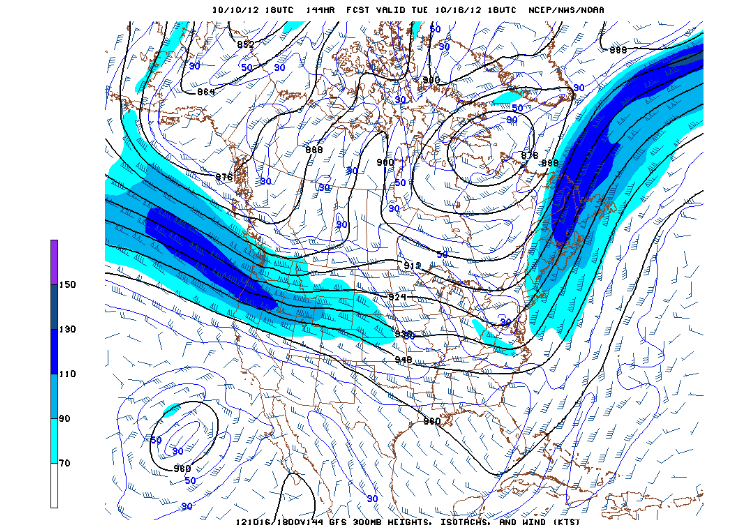
This change can best be noted in the series of  300mb level charts.

300mb analysis Wed evening 10/10/12
300mb forecast Sunday evening 10/14/12
300mb forecast Tue evening 10/16/12

Models all agree that a very moist flow will accompany the jet which suggests a strong topographic factor in the precipitation potential.  The forecast precipitable water for Monday shows the high amounts moving onto the west coast toward western Wyoming.
Precipitable Water Mon evening 10/15/12
The forecast precipitation that the model generates  for the period over the weekend ending next Tuesday shows both the area that accompanys the California upper low, mostly to the south of Star Valley and the significant rainfall on the Northwest coast which spreads inland toward and north of Star Valley.
Total precipitation forecast ending Tuesday 10/16/12

While it  is still too soon to predict the amount of rainfall that will fall in Star Valley, it is becoming more favorable for rain and  wet snow in the higher elevations due to the strong orographic influences of the strong westerly flow.  Mild temperatures should continue with snow confined to the higher elevations through early in the coming week.

Sunday, October 7, 2012

Cold Mornings but first Snow Misses Western Wyoming

Sunday morning again saw temperatures drop to unseasonably low levels across Wyoming and surrounding areas.  Clear skies, light winds and very low humidity's provided ideal conditions for the cold.  Peters Sink located at the top of Logan Canyon,  Utah dipped to minus 1, for the first observed below zero reading of the fall.  Peters Sink is typically the cold spot due to it's high elevation, around 8000 feet, and sheltered location.  However here are some other readings around the area to compare with.

Pixley  which is about 10 miles south of Cokeville dropped to 3 above with Bondurant close behind at 4.  Both Cokeville and Thayne ES dipped to 10 above with Star Valley Ranch dropping to 19 above, the coldest thus far this fall.  Places such as Salt River Summit above the valley inversion was a relatively balmy 24.

Addressing the extraordinarily dry period in Star Valley and when it could change is the real weather issue.  At Star Valley Ranch only .36 inches of precipitation has been measured since August 1st. Going even further back, just 2.28 has fallen since June 1st.  During the summer Star Valley was little affected by the Monsoon moisture to the south and has been and still is out of the storm track from off the Pacific Ocean.

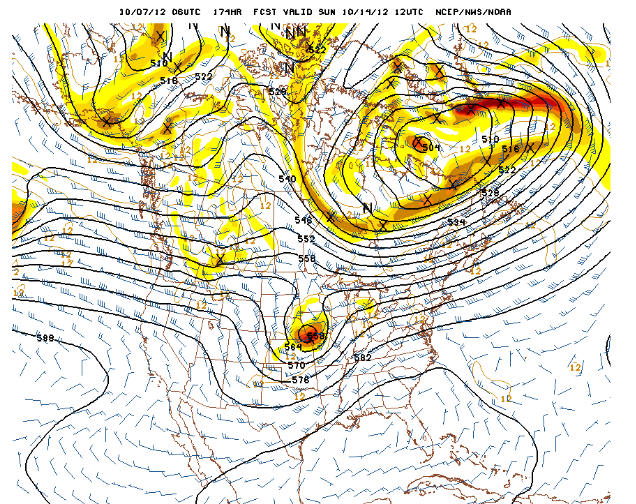
Sunday mornings 500mb chart still shows the large blocking upper high in the Gulf Of Alaska, that is shunting the storms and Pacific moisture well to the north.

Little noticeable change is expected much of this week as the 500mb forecast for Wednesday morning still keeps the storms either well to the north or south of Star Valley

However, changes will begin to occur by this coming weekend as the high pressure off the Pacific Coast begins to break down and the jet stream and Pacific storms begin moving inland across the Northwest.

500mb Forecast Sunday 10/14/12
This still does not provide much real  immediate hope of precipitation making it into Star Valley, even by next weekend.  Beyond next weekend reliability of the model forecasts is low, thus persistent of the drought pattern is likely the best solution until further notice.

There was some snow in Eastern Wyoming with the last storm and Riverton WFO has posted a map of the totals

Unfortunately the east slopes of the Wind  River mountains was the furthest west snow was reported.

Here is a list of the snowfall reported


Friday, October 5, 2012

Cold and Snow

The first shot of cold air this fall has dropped  temperatures into the teens and even lower in the valleys of western Wyoming  and surrounding areas.  Thayne ES reported the lowest in Star Valley the last couple mornings dropping to 17 above.  However some areas were even colder with Bondurant at 11 above and Pixley just south of Cokeville 12.  The coldest noted Friday morning was in the West Yellowstone area with a reading down to as low as 7 above.

Even with the colder air, it remains very dry with plentiful sunshine and there is little change expected for the next several days.  A large high pressure noted on Friday mornings 500 mb analysis is centered in the Gulf of Alaska, essentially blocking storms from reaching the Western U.S.

500 mb analysis Friday AM 10/5/12

This pattern will change little over the weekend as noted on the forecast 500mb chart for Monday morning.

There is a low pressure system off the California coast which will slowly move eastward over the weekend, but is not expected to impact Star Valley weather for several days, if at all. 

While the sunshine will warm afternoons to near 50F, the nights will continue cold.  In fact, Saturday morning could see temperatures a couple degrees colder than Friday AM.

So, where is the snow?  The cold front that went through Star Valley recently did produce snow 0ver a large part of Montana eastward across North Dakota. The St. Marys Cam  on the east side of Glacier NP this friday morning is evidence of the recent snow.


This is a scene that will not be seen in Star Valley for at least the next week. 

The long range computer models do indicate that the storm track will begin to affect the western states by the middle of October. This is the outer limit of reliability of model forecasts.  The rainy season typically gets underway in the Pacific Northwest by the later half of October, and so it is reasonable to expect this solution.  Hopefully the sooner the better with the precipitation as there are still many fires still burning across the tender dry northwest U.S.

To find out more information on these fires  go to this web site

http://activefiremaps.fs.fed.us/

Sunday, September 30, 2012

September Wrap-up and A Look Ahead

September continued the theme of Summer 2012 in Star Valley, Very warm and very dry,.

Here are the stats for the local stations in Star Valley including the dates of the Max/Min temps and the date of the peak wind in MPH.

                                 Max    Min     Rain   Peak Wind   # Days 32 F or lower
Thayne ES                 85-9  24-13   .17     38-16            15
Etna ES                      86-9  26-13    .23     32-2               7
Star Valley Ranch      82-8 35-18    .25     48-2                0
Etna 2NE                    86-9 26-13    .44     28-4                7
Alpine                         86-9 28-13    .33     33-12              2
Smoot                         80-9 27-13    .39     34-12


The most striking data is the number of mornings with freezing temperatures.  Thayne ES had half the days of the month with freezing or below. While just about 4 miles northeast at Star Valley Ranch the first freezing temperature has yet to be observed.  Thayne ES recorded the first below freezing morning on August 25 with a 31F.  The official growing season has been 5 weeks longer at Star Valley Ranch vs the colder valley locations represented by the Thayne ES observations.

While the Thayne ES observations are taken on the roof of the school, there is also the soil sensors for the school.  The first of three sensors is located just below the surface and the following graph displays the large diurnal ranges that occur near the surface.

 
Soil temperature at Thayne ES just below the surface-Sept 2012

On a couple days notably the 14th, diurnal ranges were in excess of 75F. Morning minimum of 23F was followed by an afternoon maximum to nearly 100F. This illustrates the environment for near ground crops vs most locations where the regular temperature observations are considerably higher, above the ground..

It was a much different story with sensor #2 which is buried about 2 feet below the surface.  It can be seen from the following graphic that a steady decrease in temperature occurs much of the month of September

2 foot soil temperature Thayne ES -Sept 2012


This steady downward temperature trend reflects  the overall decreasing solar radiation as we go into the Fall and a lower sun angle.  The solar radiation graphic at Thayne ES for the month shows this trend.

Solar radiation at Thayne ES Sept-2012


While there were a few mostly cloudy days in the third week of the month, overall sunny skies predominated.  The slow but steady decrease in radiation can be noted on the graph.

Now a brief  look ahead to the coming week.  It now seems assured that the first Fall like cold front will sweep across the Star Valley region by mid week.  While it appears that the main energy and precipitation will remain from the continental divide eastward,  daytime temperatures will drop from near 70F  Monday and Tuesday afternoon to not much above 50F the remainder of the week.  Snow will likely occur from areas of Yellowstone NP eastward, with much of the affect in Star Valley limited to strong gusty winds and dropping temperatures.  By Thursday morning a hard freeze is likely across Star Valley including those areas along the mountain slopes in the trees that have thus far been spared.  The remainder of the week will remain seasonably cool with freezing temperatures each night.

Following are the 500MB charts for Sunday evening and the forecast 500MB chart for Wednesday evening, Oct 3rd.

Sunday evening Sept 30-2012 500 mb analysis

500 MB forecast Wednesday evening Oct 3rd 2012

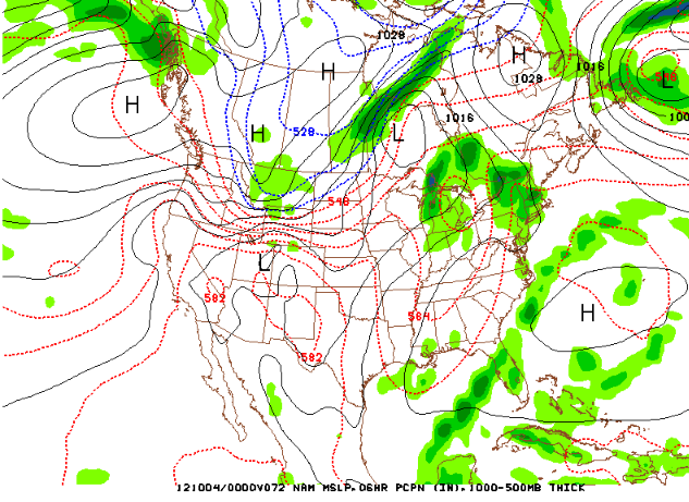
The surface forecast for Wednesday shows the Canadian high pressure moving southward east of the continental divide with the much colder air mass.
Surface pressure forecast for Wednesday evening Oct 3 2012

The only hope for precipitation with the system this far west will be stronger deepening into our area which now the computer models agree will likely not happen.

Friday, September 28, 2012

Another Great Week of Early Fall Weather

It has been a delightful month of September and several more beautiful days are expected.  Here is a sampling of the month as has been experienced in Star Valley looking at the  Etna ES weather station records.


Etna ES high and low temperatures for September 2012

The weekly weather briefing from Riverton WFO follows

http://www.crh.noaa.gov/riw/?n=weatherbriefing

As indicated from the briefing there is a threat of a change in the warm, dry weather pattern by the end of this coming week.  It is still too soon to express with any degree of confidence if this will be the first fall like weather this year.  The reliability of the computer models this far in advance is limited.