 | ||||||||
| Sunrise temperatures July 28 2015
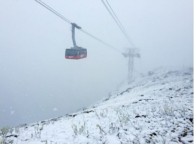
Snow fell in the mountains above about 8000 feet with the cold frontal passage Monday afternoon.
Riverton Forecast Office has provided a summary
of the storm including a possible tornado
in the Big Horn Mountains.
A strong storm system moved through the region on Sunday and Monday, its impact was felt across much of western and central Wyoming.
As the storm strengthened to our west, dry southwest flow delivered dangerous fire weather conditions to areas east of the Divide where the abundant grasses have been drying over the past couple of weeks.
Red Flag Warnings, indicating very high fire danger, were issued for Sunday afternoon and again for Monday. Unfortunately these warnings were verified when several grass fires broke out across the region, including a large fire near Bar Nunn, which is part of the Casper metro area, and another fire that started near Lander after a powerline was blown down in the strong wind.
In addition to the wind and fire danger, severe thunderstorms broke out along the cold front. Severe weather reports ranged from downed tree limbs to a possible tornado that touched down in the Bighorn Mountains, destroying 7 camper trailers. The National Weather Service will survey the damage on Tuesday, July 28th and confirm whether the damage was from a tornado or straight line winds, and supply an EF rating if appropriate. Click here to see a compiled list of severe storm reports from Monday.
Very cold air settled in behind the front, with periods of snow falling over the western mountains. Freezing temperatures are expected overnight in the western valleys in addition to the higher elevations.
A significant amount of instability, moisture, lift, and spin was present in the atmosphere across northern Wyomong on Monday. This creates an environment favorable for tornadoes and one could have formed in a severe thunderstorm that tracked through the northeastern quarter of the Big Horn Basin on Monday afternoon.
There were a lot of reports of wind damage, and this area of the Bighorn Mountains is notorious for straight line wind damage, so a team of meteorologists from the National Weather Service office in Riverton is going to head out at first light and determine whether or not the damage was from a tornado or from straight line winds.
Either way, we did receive a report of 7 camper trailers described by Emergency Management as "destroyed." We also received reports of several uprooted trees and large tree trunks snapped in half. None of these trailers were known to be occupied at the time and no injuries, fatalities, or missing persons have been reported.
Strong winds developed ahead of the cold front as fast flow aloft was easily mixed down in the hot afternoon air. Widespread 30 to 40 mph winds were accelerated by thunderstorms that developed in the afternoon. Some of these storms produced wind gusts in excess of 70 mph and caused damage across large swaths of western and central Wyoming. Most of the damage reports included tree limbs down, but there was also a report of the strong wind causing a power line to topple over near Lander and start a wildfire. There were also reports of carports damaged in Hayatville, Wyoming.
Click here to see a pop-up list of the highest winds reported during this event.
A large fetch of hot, dry air was fed in ahead of the approaching story system, leading to elevated fire danger across much of the state on Sunday and especially on Monday as winds increased.
After a couple of slow fire seasons and a wet spring and early summer, there was plenty of grass and other fine vegetation ready to burn after just a couple of weeks of hot, dry weather. A few dry lightning strikes and some strong Wyoming winds was all it took to get some of these fires started, the cause of some of these fires remains under investigation.
The "good" thing about these big events is that they usually advertise themselves well. Messaging about the high fire danger on Sunday and Monday begain on Thursday of last week with our first ever event-driven Multimedia Fire Weather Briefing issued on Friday to highlight the complexities of this system. The first Red Flag Warning for this event was issued on Saturday, with an average of 34 hours of lead time for the Monday event, 16 hours for the Sunday event.
There were two fairly high-impact fires. One occurred near Bar Nunn (Casper Metro Area) that prompted an evacuation order and closed several roads and off ramps along Interstate 25. The fire is rumored to be caused by lightning and ended up scortching a couple of fences but all lives and homes in the area were spared. The other wildfire was started when power lines were blown down by the wind in the Lander foothills. Power was out for over 5,000 residents of Lander and Hudson for several hours and it took firefighters even longer to extinguish this wind-driven blaze.
|
A BLOG ABOUT WEATHER FORECASTING AND OBSERVING AS IT RELATES TO STAR VALLEY, WYOMING IN PARTICULAR
Tuesday, July 28, 2015
Summary of Mondays Powerhouse Cold Front in Wyoming.
Subscribe to:
Post Comments (Atom)

No comments:
Post a Comment