After a couple mild days, winter will return to Star Valley later Thursday through the weekend. A strong cold front followed by a cold upper low pressure trough will move across the region later Thursday and Friday.
Following is a link to a video presentation from Riverton Forecast Office focusing on the approaching storm
http://www.crh.noaa.gov/riw/?n=weatherbriefing
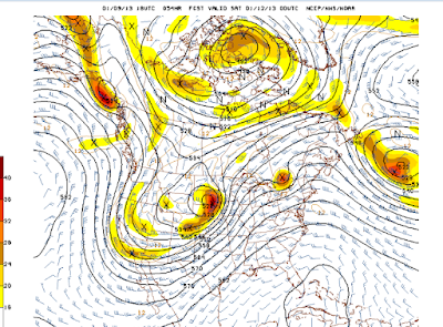
The following sequence of 500mb forecast charts show the dramatic change in pattern across the western U.S.
 |
| Wednesday Evening |
|
 |
| Thursday evening |
|
 |
| Friday Evening |
|
 |
| Saturday Evenig |


No comments:
Post a Comment