Wednesday, February 29, 2012

Strong Cold Front Crosses Star Valley Wednesday Afternoon

The next in a series of powerful upper level troughs of low pressure is moving eastward toward Star Valley this afternoon.  This can be noted on the mid-day Water Vapor Satellite imagery

Mid day Water Vapor Imagery 2/29/12


This trough is driving a strong cold front toward Star Valley and at noon it was crossing the Snake River Valley near Pocatello and Idaho Falls.  

The surface analysis shows the frontal location around 8am this morning, and at its' present rate of motion will cross the Star Valley area between 2:30 and 4pm. 


The front will be accompanied by strong, gusty winds up to 40 mph and a period of heavy snow.  Temperatures will drop sharply from around  freezing to near 20 degrees after its passage.  The system is moving rapidly, therefore, the duration of heavy snowfall will be only a couple of hours.  A quick 2-4 inches of snow could result with lighter amounts continuing through the night.

Travel will be affected due to reduced visibilities and snow packed roads once the front passes.

Monday, February 27, 2012

Snowy Week Ahead for Star Valley

The storm track remains across Star Valley and will provide at least 2 significant snow events this coming week.  Sunday was a day in which cold air aloft, with a departing trough, brought snow showers  across the valley.  A photo taken from just west of Star Valley Ranch Sunday afternoon looking southeast, captured a typical  scene,  a low topped convective snow shower that was moving eastward from the Bedford area.


The water vapor satellite imagery from noon Monday shows the two systems that will be affecting Star Valley this week.
Water Vapor Imagery Monday Morning 2/27/12
A large area of cloudiness is already spreading northeastward from the system located over California this Monday morning.  Today's 500 mb analysis shows both the trough over California and probably the bigger snow producer of the two  troughs, moving through the Gulf Of Alaska.

500 mb Analysis Monday morning 2/27/12

By Tuesday morning the California trough will be heading eastward across the intermountain region with the next stronger system approaching the Pacific Northwest.

500 mb forecast Tuesday morning 2/28/12

Snow will spread and increase across Star Valley Monday night and continue well into Tuesday as the upper trough passes by to the east.  With the stronger upward motion in the trough remaining just to the south, snow amounts are not expected to be large.  The model forecast precipitation for the 24 hours ending Tuesday morning suggest from 2-4 inches in the valley.


The higher snowfall totals should be just to the south.

There will be a brief lull in the snow by later Tuesday,  however, the Gulf of Alaska system will quickly begin affecting the area by Wednesday, with likely a longer duration of snow.

The forecast 500mb conditions for Thursday morning display a strong westerly flow of cold  and moist air across western Wyoming which will lead to significant snowfall totals, particularly in the mountains.
500 mb forecast Thursday morning 3/1/12


The model forecast precipitation for the 48 hour period from Wednesday morning to Friday morning suggest snowfall totals of 1-2 feet in the mountains including the Tetons and Salt Ranges.  Unlike last weeks storm, it will remain all snow in Star Valley,  with totals possibly ranging upwards from 6 inches to a foot.
48 hour forecast precipitation from Wednesday morning to Friday morning 2/29/12-3/2/12

While a way off yet, the models paint  a much improved weather picture this coming weekend as an upper ridge moves into the western states.

500 mb forecast Sunday Morning 3/4/12

Friday, February 24, 2012

SNOTEL, what, how and where?

The word snow is a frequent topic of conversation in Star Valley.  There is either too much, too little, it is around too long or it is too deep.  Without it Star Valley would not be one of the most beautiful valleys in this great country.  Snow is typically covering the ground  for nearly half of the year in many parts of the valley.  During the winter of 2010-2011 there was at least an inch on the ground at the Smoot  CoCoRaHS site from November 9th until  May 28th, or about 200 days.  This was over half a year!  This winter there was an even earlier start to the snow season with the continuous snow cover beginning on November 5th, 2011.  We can hope that Spring will come a little earlier this year!

The measurement of the amount of snow on the ground and its water content is critical to anticipating how much runoff from the spring melt will occur.  Thus the SNOTEL program is a major player in this.

SNOTEL is an acronym for Snowpack Telemetry.  It is  an automated system of snowpack and related climate sensors operated by the Natural Resources Conservation Service(NCRS) of the United States Department of Agriculture in the Western United States and has been around since the mid 1970's. 

There are over 600 SNOTEL sites in 13 states, including Alaska. The sites are generally located in remote high-mountain watersheds where access is often difficult or restricted.

All SNOTEL sites measure snow water content, accumulated precipitation, and air temperature. Some sites also measure snow depth, soil moisture and temperature, wind speed, solar radiation, humidity, and atmospheric pressure. These data are used to forecast yearly water supplies, predict floods, and for general climate research.


SNOTEL uses meteor burst communications technology to collect and communicate data in near-real-time. VHF radio signals are reflected at a steep angle off the ever present band of ionized meteor trails existing from about 50 to 75 miles above the earth. Satellites are not involved; the NRCS operates and controls the entire system.


Sites are designed to operate unattended and without maintenance for a year. They are battery powered with solar cell recharge. The condition of each site is monitored daily when it reports on 8 operational functions. Serious problems or deteriorating performance trigger a response from the NRCS electronics technicians located in six data collection offices. 

The SNOTEL sites are polled by 2 master stations operated by NRCS in Boise, Idaho and Ogden , Utah. A central computer at the NRCS's  National Water and Climate Center (NWCC) in Portland, Oregon controls system operations and receives the data collected by the SNOTEL network. 


Basic SNOTEL sites have a pressure sensing snow pillow,  storage precipitation gauge,  and air temperature sensor. On-site microprocessors provide functions such as computing daily maximum, minimum, and average temperature information. Generally, sensor data is recorded every 15 minutes and reported out in a daily poll of all sites. Special polls are conducted more frequently in response to specific needs.

There are two SNOTEL sites in the Salt Range providing information for snowmelt runoff into the Salt River.  They are :

Cottonwood Creek SNOTEL site


Willow Creek SNOTEL site

There is an excellent web page that will enable any user to quickly ascertain the current snow season at 
each SNOTEL site compared with the normal and the greatest and least over the life of the site, which in 
most cases is over 30 years.
http://www.nwrfc.noaa.gov/snow/
Just tag each site with your cursor and it will display the stations current  data.


In addition on the home page of starvalleyweather.com  is a link to the Willow Creek SNOTEL site
displaying  temperatures, snow depth, snow water content  along with accumulated precipitation for the water year,
which begins Oct. 1. 


Wednesday, February 22, 2012

Powerful Polar Jet Stream Blasts Western Wyoming

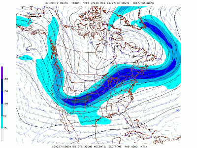
Star Valley has avoided the impact of the Polar Jet and it's associated storm track much of the winter.  Such was not the case the past couple of days as was well forecast by the computer models. An intense band of jet stream winds raced southeastward across our area Wednesday.  The 300 mb analysis (around 30,000 feet MSL) from Wednesday evening shows the core of the 140-160 kt jet aimed right for western Wyoming


Around mountain top level at 700mb Wednesday evening winds were running from 60-70 kt.

Combined with warm air that spread eastward, conditions were favorable for strong mixing of the jet stream winds to the ground level at most locations.  The higher elevations, particularly mountain ridges and passes were most affected.  Few observations are available at these remote locations with a couple notable exceptions.  The automated site atop Mt. Coffin on the southern end of the Wyoming Range at almost 11,000 feet hit a peak gust of 140 mph at 8:30 pm.  The observations at the top of the Ski Lift above Teton Village at 10,300 feet had a peak gust of 76 mph around 4pm and 77 mph at 9:45 pm..

Exceptionally strong winds affected much of Star Valley Wednesday afternoon and evening.  Some of the notable gusts and time of occurrence were:

Alpine                      G62 mph   12:32 pm
Star Valley Ranch      G56 mph    7:17 pm
Osmond Elementary   G54 mph    7:45 pm
Thayne Elementary    G50 mph    7:29 pm
Etna Elementary         G47 mph   6: 44 pm
Smoot                        G43 mph   7:40 pm

Preceding the strong winds and warmer air, snow fell across all of Star Valley much of Tuesday before changing to rain Tuesday night.  Snow reports ranged upwards from just a few inches in the Afton and Smoot area to an observed 15 inches just to the southeast of Thayne.  Star Valley Ranch measured an even foot bringing the current snow depth to 40 inches. A reliable observer just northeast of Etna had almost 8 inches before the rain made it a sloopy mess.

Colder air will arrive later tonight dropping temperatures well below freezing by morning where they will remain through the coming weekend.. This will lead to very icy conditions Thursday morning in areas where the melting that occurred on Wednesday, refreezes.

Sunday, February 19, 2012

Weekend Snow Gone, But More on The Way

The weekend storm has moved on with generally 2 inches of new snow in most Star Valley locations. The observer south of Smoot only had an inch with Star Valley Ranch somewhat an outlier with 6 inches observed by early  Sunday afternoon.  The snow pack still remains a little below normal, and certainly far behind last year in the adjacent mountains.


The Willow Creek Snotel has shown a strong recovery from the very slow start on the Winter snow pack.

Now looking ahead a major shift is underway with the storm track and more importantly the core of the wintertime polar jet taking direct aim at Star Valley this coming week.

Beginning this Sunday evening the weekend trough is moving on east as the strong polar jet is crossing the high pressure ridge in the Gulf of Alaska.
300 mb Analysis Sunday evening 2/19/12

By mid week the 130kt polar jet will be driving eastward just to the north of Star Valley.

300 mb forecast Wednesday evening 2/22/12


And by the end of the week while a deep trough develops over the central states, models are indicating strong low pressure troughing will be approaching the region.

300 mb forecast Friday evening 2/24/12


Although a 7-day model forecast is always of questionable accuracy, the idea of a major upper system crossing the western states appears to be a concern for next weekend

300mb forecast Sunday evening 2/26/12

Confidence is high that it will be a very snowy week, beginning  Tuesday.  The model forecast total precipitation for the next 7 days indicate a large area of greater than an inch of water content over much of the western Wyoming mountains including the Star Valley.
Total Precipitation for period from Feb 19-26 2012


Given the likely extended duration with the very strong, westerly upslope flow, new snow fall totals of 2-4 feet are certainly possible over the Tetons, Salt and Wyoming Ranges.

How much will accumulate on the floor of Star Valley is more of a question as the air mass moving into the area by Wednesday will warm considerably leading to very wet snow,  possibly changing to rain for a time.  However amounts of a foot or more certainly are a good possibility at least at higher valley locations, such as the south end and places such as Star Valley Ranch where elevations are near 6500 feet.

By Thursday colder air will move back across the area turning all the precipitation back to snow.

By next Sunday there is a good possibility that the mountain snow pack will be increased to above average levels, which would be quite the recovery from where they were in early January.

Friday, February 17, 2012

More Serious Snow On The Horizon

While there has been at least a trace of snow observed at Star Valley Ranch for the past 10 days it has resulted in just 12 inches. Almost half(5 inches) fell last Sunday morning.  There are signs that the storm track, which has been bypassing Star Valley much of February, will be more of a player in our weather for the remainder of the month.

A weak upper trough passing through the area will result in a couple inches of new snow today(Friday).  This should be a rather low moisture content snow with snow to liquid ratios around 20:1.  That is, if 20 inches of snow fell and that snow was melted, it would produce 1 inch of liquid precipitation.  A wet snow would have ratios of 10:1 or less.


Examining the morning upper air analysis shows the weak system resulting in today's snow  at 700mb(10,000 ft) tracking across the northern Rockies:


700 mb Analysis Friday Morning Feb 17 2012
While today's snow is rather obscure on the water vapor imagery this morning, a much more powerful storm is approaching the Pacific Northwest  coast.


Water Vapor Imagery Friday AM February 17, 2012

There are still signs that the storm moving onto the Northwest coast later today will weaken as the energy again tries to split. Unlike recent systems, Star Valley and western Wyoming and southeastern Idaho should receive a period of significant snow as the upper trough passes this weekend.


With the current weak system  passing on to the east the associated snow is expected to generally end by this evening.  

Looking ahead by late Saturday afternoon, snow will return to the area as the storm now moving toward the Pacific Northwest, although having weakened,  will be crossing the Idaho/Western Montana /Western Wyoming region.

700 mb Forecast Saturday evening Feb 18 2012  
 Below is an experimental forecast for the model snowfall over about the next 3 days.  Basically, displayed are various model solutions for the same forecast period.  By varying initial conditions of several different models, a total of about 16 different solutions of total snowfall are made for the Star Valley area.  While the range of forecast snow is from just a couple inches to nearly a foot, the mean of all models is for around 6 inches.  Probably of greatest importance is that all the solutions agree that the bulk of the snow will fall beginning late Saturday through Sunday evening.


For additional technical information as well as access to other model forecast fields and locations  check out  this link:

 http://www.spc.noaa.gov/exper/sref/eplumes/index.php?PRM=Total-SNO&INC=ALL&NNC=&RT=09&max=&min=&SID=SVR

Greg Carbin the Warning Coordination Meteorologist at the Storm Prediction Center has developed the SREF Display and is looking for feedback.


SREF Forecast Total Snowfall from Friday morning until Monday evening Feb 17-20 2012 for Star Valley  

Forecast snowfall amounts depend on several factors including snow to liquid ratios, accuracy of model solutions and location relative to terrain influences.  Here in Star Valley all these play important roles.  Thus, a forecast of how much snow is going to fall is one of the more difficult weather parameters to make.

Given these caveats it does appear that over the weekend, several inches of new snow are likely with the possibility of the most favored valley locations receiving from 4-6 inches along the west slopes of the Salt Range such as Smoot, Turnerville, Bedford and Star Valley Ranch.  It does appear that higher elevations in the Tetons and Salt/Wyoming Ranges could get over a  foot.    

Wednesday, February 15, 2012

Active Cloud Day over Star Valley Captured on the Star Valley Ranch Cam

The atmosphere over Star Valley on February 15, 2012, was moist and seasonably cold.  The mid-February sun resulted in an interesting cloud day. Stable strato-cumulus clouds covered the valley during the morning.  By early afternoon heating resulted in the clouds over the valley dissipating while even stronger heating of the higher terrain of the Caribou Range on the west side of the valley developed rather vigorous convective updrafts.  Cumulus clouds quickly glaciated given the cold air aloft and snow showers then pelted the mountains.  Since the steering winds were quite light these cumulus clouds remained over the Caribou Range during their relatively short life cycle.  Upon cessation of daytime heating, the clouds quickly became strato-cumulus and once again spread back across the valley.

All of this rather active cloud day was captured by the web cam located in Star Valley Ranch. The animation speed of the video is 12 frames per second, with a minute between frames.

http://youtu.be/TsiXP3v1-Es

Saturday, February 11, 2012

Snow So Far This Season in Star Valley vs the Winter of 2010-2011

There are two active CoCoRaHS observers in Star Valley.  One is located south of Smoot and the other one is at my home in Star Valley Ranch.  The official snow season begins on Oct 1 each year.  As of today, February 11th the total at the Star Valley Ranch site is 110 inches with 106 inches measured at the Smoot location.  At the bottom of this blog will be the listing by day of the snowfall, precipitation and snow depth for each of the two locations.

The  Smoot CoCoRaHS  observer had measured 155 inches  last year up until Feb 10th 2011. While this is about 4 feet more than  reported thus far this year, another 132 inches fell after Feb. 10 2011 for a season total of 287 inches, or almost 24 feet!

An observer located near Thayne measured 210 inches for the 2010-2011 snow season or nearly 18 feet.  So far this year he reports 93 inches.  Another reliable observer located just northeast of Etna reports they have measured 66 inches since Oct.7 2011.

While we are far below last years snowfall, as can be seen from the Smoot observer,  another 11 feet  was measured after Feb. 10, 2011.  While the large scale jet stream pattern continues to keep the storm track away from Star Valley,  there is still much of the snow season still ahead.

For the past two winters there has been a web cam recording the snow depths at Star Valley Ranch.  The current cam view of the snow stake can be seen at http://www.camviewing.com/mosaic/.

There are two videos available to compare last winter with the current one.  The first link was taken using the camera that has since been moved to the Star Valley Ranch Public Works building and provides a view across the valley.  The cam being used to monitor the snow stake this year is of somewhat less quality.

One photo a day grabbed around noon is used to put together a movie of the history of each year.

The snow season 2010-2011 can be found here: 

http://www.youtube.com/watch?v=pvym_ENf6L8


For the winter of 2011-2012  the loop begins on December 14th and so far covers every day up to February 10th:


http://www.youtube.com/watch?v=gbqPGHeX98w

Following are the daily reports from the two CoCoRaHS sites so far this snow season:

WY-LN-2
Smoot 4.9 SSE
Lat: 42.5519166
Lon: -110.8884333
WY-LN-17
Thayne 4.7 NNE
Lat: 42.976495
Lon: -110.949658
* indicates Multi-Day Accumulation Report
Station               WY-LN-2  WY-LN-17
DatePrecipSnowfallCore PrecipTotal Snow DepthTotal SWE  PrecipSnowfallCore PrecipTotal Snow DepthTotal SWE
10/01/2011  0.000.0NANANA  0.000.0NANANA
10/02/2011  0.000.0NANANA  TNANANANA
10/03/2011  0.000.0NANANA  0.000.0NANANA
10/04/2011  0.02NANANANA  0.000.0NANANA
10/05/2011  0.38NANANANA  0.08NANANANA
10/06/2011  0.481.0NA1.0NA  0.270.5NA0.5NA
10/07/2011  1.0814.0NA15.0NA  0.9010.0NA8.0NA
10/08/2011  0.242.0NA14.0NA  0.261.0NA4.0NA
10/09/2011  0.000.0NA5.0NA  0.03NANA1.0NA
10/10/2011  0.000.0NA3.0NA  0.000.0NATNA
10/11/2011  0.14NANA1.0NA  0.09NANANANA
10/12/2011  0.19NANANANA  0.32NANANANA
10/13/2011  0.000.0NANANA  0.000.0NANANA
10/14/2011  0.000.0NANANA  0.000.0NANANA
10/15/2011  0.000.0NANANA  0.000.0NANANA
10/16/2011  0.000.0NANANA  0.000.0NANANA
10/17/2011  0.42NANANANA  0.64NANANANA
10/18/2011  0.000.0NANANA  0.000.0NANANA
10/19/2011  0.000.0NANANA  0.000.0NANANA
10/20/2011  0.000.0NANANA  0.000.0NANANA
10/21/2011  0.000.0NANANA  0.000.0NANANA
10/22/2011  0.000.0NANANA  0.000.0NANANA
10/23/2011  0.000.0NANANA  0.000.0NANANA
10/24/2011  0.000.0NANANA  0.000.0NANANA
10/25/2011  0.08NANANANA  0.000.0NANANA
10/26/2011  0.000.0NANANA  0.000.0NANANA
10/27/2011  0.000.0NANA  0.000.0NANANA
10/28/2011  0.000.0NANANA  0.000.0NANANA
10/29/2011  0.000.0NANANA  0.000.0NANANA
10/30/2011  0.000.0NANANA  0.000.0NANANA
10/31/2011  0.000.0NANANA  0.000.0NANANA
11/01/2011  0.10NANANANA  0.000.0NANANA
11/02/2011  0.000.0NANANA  0.000.0NANANA
11/03/2011  0.000.0NANANA  0.000.0NANANA
11/04/2011  0.000.0NANANA  0.000.0NANANA
11/05/2011  0.192.0NA2.0NA  0.324.00.324.0NA
11/06/2011  0.072.0NA3.0NA  0.072.0NA5.0NA
11/07/2011  0.000.0NA3.0NA  TTNA3.0NA
11/08/2011  0.000.0NA3.0NA  T0.2NA3.0NA
11/09/2011  0.000.0NA2.0NA  TTNA2.5NA
11/10/2011  0.000.0NA2.0NA  0.000.0NA2.5NA
11/11/2011  0.000.0NA2.0NA  0.000.0NA2.0NA
11/12/2011  0.143.0NA4.0NA  0.042.0NA4.0NA
11/13/2011  0.5612.0NA14.0NA  0.5314.5NA13.0NA
11/14/2011  0.152.0NA15.0NA  0.203.5NA12.0NA
11/15/2011  0.000.0NA12.0NA  0.000.0NA9.0NA
11/16/2011  0.000.0NA11.0NA  T0.0NA8.0NA
11/17/2011  0.000.0NA10.0NA  0.000.0NA8.0NA
11/18/2011  0.062.0NA11.0NA  0.345.0NA10.0NA
11/19/2011  0.398.0NA15.0NA  0.153.0NA11.0NA
11/20/2011  0.000.0NA14.0NA  TTNA10.0NA
11/21/2011  0.153.0NA15.0NA  0.194.5NA14.0NA
11/22/2011  0.000.0NA14.0NA  TTNA11.0NA
11/23/2011  0.000.0NA13.0NA  TTNA10.0NA
11/24/2011  0.000.0NA13.0NA  0.000.0NA8.0NA
11/25/2011  0.112.0NA15.0NA  0.020.5NA8.0NA
11/26/2011  0.000.0NA14.0NA  0.031.0NA8.0NA
11/27/2011  0.000.0NA13.0NA  0.000.0NA7.0NA
11/28/2011  0.000.0NA13.0NA  0.000.0NA7.0NA
11/29/2011  0.000.0NA12.0NA  TTNA6.0NA
11/30/2011  0.000.0NA12.0NA  0.000.0NA6.0NA
12/01/2011  0.092.0NA14.0NA  0.092.0NA8.0NA
12/02/2011  0.000.0NA14.0NA  0.000.0NA7.0NA
12/03/2011  0.000.0NA13.0NA  0.102.0NA9.0NA
12/04/2011  0.122.0NA15.0NA  0.010.2NA8.0NA
12/05/2011  0.071.0NA16.0NA  TTNA8.0NA
12/06/2011  0.000.0NA16.0NA  0.000.0NA8.0NA
12/07/2011  0.000.0NA16.0NA  0.000.0NA8.0NA
12/08/2011  0.000.0NA16.0NA  0.000.0NA8.0NA
12/09/2011  0.000.0NA16.0NA  0.000.0NA8.0NA
12/10/2011  0.000.0NA16.0NA  0.000.0NA8.0NA
12/11/2011  0.000.0NA16.0NA  0.000.0NA8.0NA
12/12/2011  0.000.0NA16.0NA  0.000.0NA8.0NA
12/13/2011  0.000.0NA16.0NA  0.000.0NA8.0NA
12/14/2011  0.092.0NA17.0NA  0.082.0NA10.0NA
12/15/2011  0.061.0NA17.0NA  0.031.0NA11.0NA
12/16/2011  0.000.0NA17.0NA  0.000.0NA9.0NA
12/17/2011  0.000.0NA16.0NA  0.000.0NA9.0NA
12/18/2011  0.000.0NA16.0NA  0.000.0NA9.0NA
12/19/2011  0.000.0NA16.0NA  0.000.0NA9.0NA
12/20/2011  0.000.0NA16.0NA  0.000.0NA9.0NA
12/21/2011  0.000.0NA16.0NA  0.000.0NA12.0NA
12/22/2011  0.193.0NA19.0NA  0.193.0NA12.0NA
12/23/2011  0.000.0NA19.0NA  0.000.0NA12.0NA
12/24/2011  0.000.0NA19.0NA  0.000.0NA12.0NA
12/25/2011  0.000.0NA19.0NA  0.000.0NA12.0NA
12/26/2011  0.000.0NA18.0NA  0.000.0NA12.0NA
12/27/2011  0.000.0NA18.0NA  0.000.0NA10.0NA
12/28/2011  0.000.0NA18.0NA  0.000.0NA10.0NA
12/29/2011  0.333.0NA20.0NA  0.801.0NA10.0NA
12/30/2011  0.000.0NA19.0NA  0.000.0NA10.0NA
12/31/2011  0.132.0NA20.0NA  0.425.0NA15.0NA
01/01/2012  0.000.0NA18.0NA  0.000.0NA14.0NA
01/02/2012  0.000.0NA18.0NA  0.000.0NA13.0NA
01/03/2012  0.000.0NA18.0NA  0.000.0NA13.0NA
01/04/2012  0.000.0NA17.0NA  0.000.0NA12.0NA
01/05/2012  0.000.0NA17.0NA  0.000.0NA12.0NA
01/06/2012  0.000.0NA17.0NA  0.000.0NA11.0NA
01/07/2012  0.000.0NA17.0NA  0.000.00.0011.03.90
01/08/2012  0.000.0NA17.0NA  TTNA11.0NA
01/09/2012  0.000.0NA17.0NA  0.000.0NA11.0NA
01/10/2012  0.000.0NA17.0NA  0.000.0NA11.0NA
01/11/2012  0.142.0NA19.0NA  0.142.0NA13.0NA
01/12/2012  0.000.0NA19.0NA  0.000.0NA13.0NA
01/13/2012  0.000.0NA19.0NA  0.000.0NA13.0NA
01/14/2012  0.000.0NA19.0NA  0.000.0NA12.0NA
01/15/2012  0.000.0NA19.0NA  0.000.0NA12.0NA
01/16/2012  0.081.0NA20.0NA  0.081.0NA13.0NA
01/17/2012  0.000.0NA20.0NA  0.000.0NA13.0NA
01/18/2012  0.000.0NA20.0NA  0.000.0NA13.0NA
01/19/2012  0.729.0NA27.0NA  0.7010.0NA21.0NA
01/20/2012  0.595.0NA30.0NA  0.605.0NA23.0NA
01/21/2012  0.575.0NA35.0NA  0.352.0NA25.0NA
01/22/2012  0.634.0NA34.0NA  0.494.0NA26.0NA
01/23/2012  0.000.0NA34.0NA  TTNA26.0NA
01/24/2012  0.203.0NA35.0NA  0.204.0NA28.0NA
01/25/2012  0.000.0NA34.0NA  TTNA27.0NA
01/26/2012  0.000.0NA34.0NA  0.040.5NA27.0NA
01/27/2012  0.313.0NA36.0NA  0.245.0NA30.0NA
01/28/2012  0.000.0NA34.0NA  0.000.0NA28.0NA
01/29/2012  0.000.0NA34.0NA  0.000.0NA27.0NA
01/30/2012  0.000.0NA34.0NA  0.000.0NA25.0NA
01/31/2012  TTNA34.0NA  0.041.0NA25.0NA
02/01/2012  0.000.0NA34.0NA  0.000.0NA25.0NA
02/02/2012  0.162.0NA35.0NA  0.153.0NA27.0NA
02/03/2012  0.000.0NA34.0NA  0.000.0NA26.0NA
02/04/2012  0.000.0NA33.0NA  0.000.0NA25.0NA
02/05/2012  0.000.0NA33.0NA  0.000.0NA25.0NA
02/06/2012  0.000.0NA33.0NA  0.000.0NA25.0NA
02/07/2012  0.000.0NA33.0NA  0.000.0NA25.0NA
02/08/2012  0.000.0NA33.0NA  0.020.5NA25.0NA
02/09/2012  0.172.0NA34.0NA  0.062.0NA26.0NA
02/10/2012  0.000.0NA33.0NA  TTNA25.0NA
02/11/2012  0.141.0NA34.0NA  0.092.0NA25.0NA

Thursday, February 9, 2012

Pattern Change Again, Still No Big Snows in Sight for Star Valley

Weak disturbances tracking southeastward across Star Valley have produced periods of light snow the past couple of days.  Reported snow totals throughout the valley have generally been from 1 to no more than 2 inches.  Snow depth range from a reported 2 feet at the Alpine and Star Valley Ranch locations  to close to 3 feet south of Smoot.

A photo taken this morning in Star Valley Ranch is typical of many areas in the valley


In other parts of the country this sight could result in anxiety and travel concerns, for Star Valley residents it is just another winter day.  However, in other regions of the World what we have to deal with in Star Valley, even during a snowy winter, is small potatoes.  In particular the Japanese Alps on Honshu Island,  one of the snowiest locations on earth,  experience amazing snowfalls.

Here are a couple photos from this region.


A very interesting blog is available discussing the snowier parts of the globe:


http://www.wunderground.com/blog/weatherhistorian/article.html?entrynum=60

Looking ahead the current pattern with a high pressure ridge to the west of Star Valley

500 mb analysis Thursday Morning 2/9/12


is forecast to once again readjust toward a split flow pattern, directing storms systems both to the north and south.

By Tuesday of next week this split flow will be in place

500 mb forecast Tuesday 2/14/12

with the storm track across the Southwestern States and in western Canada.

While this does not favor a dry weather regime for Star Valley, any snow that falls will be generally light, similar to what has occurred recently.  An interesting  way to look at what the models  are forecasting is through a meteogram over the next week or so. This one is for Jackson Wyo

Meteogram Jackson WY Feb 9-17 2012


Of particular interest over the next week, based on the model, is that it only can generate a total of 14 mm of precipitation which converted to inches is around a half inch. Most of that is toward the end of next week.  Additionally no big temperature changes are likely until at least the end of next week as the cold air in Canada remains north of us.

Tuesday, February 7, 2012

Star Valley Winter Inversions

Once again this week Star Valley(as has been the situation several times this winter) is being affected by a strong temperature inversion. Since instrumented balloons sample the vertical structure of the air mass at widely spaced locations(the closest sites to Star Valley are Riverton  and Salt Lake City), the only real way to detect the inversions is by sampling the temperatures at varying elevations around the valley.

As an example of a vertical temperature profile that is similar to the one over Star Valley under these conditions, is the radiosonde released a couple mornings ago at Kelowna in southern British Columbia.

Kelowna, British Columbia 1200GMT 2/5/2012
In this case the temperatures were warmer at 700 mb(10,000 feet) than near the ground.


Following are the meteograms of temperatures for the last 5 days(Feb 3-7) of observations from several weather stations in and near Star Valley.


The Afton station has been most affected by the persistent inversion


Afton Temperatures Feb 3-7 2012

It is apparent that the inversion became established the night of February 4th and for the following three mornings minimums dipped to well below zero.  During the afternoon, even under sunny conditions, temperatures could only climb into the mid teens.


A similar scenario is observed by the station at Thayne Elementary School.  

Thayne ES Temperatures Feb 3-7 2012

Once the inversion was established on the morning of the 4th, minimums have been well below zero with afternoon highs briefly reaching to about 20 above.


At the Star Valley Ranch station which is about 300 feet above the valley floor as well as adjacent to the west slopes of the Salt Range, temperatures typically are not as cold under strong inversion conditions.


Star Valley Ranch Temperatures Feb 3-7 2012
Not only are nighttime minimums not as cold as the valley floor(lowest observed was 3 above)but the sun is more effective in warming the afternoons with maximums running 15-20 degrees higher than at the Afton Station!  


The Box Y station, which is located in the Greys River Canyon, is interesting as well.  While strong nighttime inversions develop due to the sheltering affects of the Wyoming/Salt Ranges, the canyon is considerably narrower than Star Valley, which allows the daytime heating to more effectively remove the inversions.


Box-Y Temperatures Feb 3-7 2012
While it gets as cold as  the coldest Salt River Valley locations at the  Box Y Station, afternoon temperatures have been near or above freezing, similar to Star Valley Ranch.


During the morning hours there have been areas of fog trapped under the inversion.  An example of this is the photo taken Sunday morning  near Grover  where the temperature at the time was minus 8F.


Sunday morning February 5 2012

In this photo is visible the thin layer of fog.  Also visible is  the accumulated Hoar Frost that has been deposited on the trees by the fog.  The fog has been much thicker during the mornings at times near the Salt River.


By the end of February the sun will be providing sufficient insolation that nighttime inversions will weaken considerably during the afternoon.

Thursday, February 2, 2012

Ho-Hum

Ho-Hum describes the weather pattern expected in Star Valley well into the month of February.  It was fortunate that the nearby mountains received a couple big storms recently as there is little chance of addition to the snow pack for some time.  As of Feb 2 the SNOTEL site at Willow Creek  indicated almost normal snow pack had been reached.


Looking ahead at the large scale flow pattern places Star Valley far removed from the storm track for the foreseeable future.

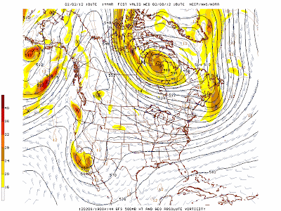
500 mb forecast Sunday 2/5/12  

500 mb forecast Wednesday 2/8/12
500 mb forecast Saturday 2/11/12

This quiet weather period should be dominated by sunny days and cold nights.  Inversions will dominate the valleys, including Star Valley, with the warmer temperatures in the higher elevations both day and night.  With the steadily increasing amount of daytime heating with longer daylight, coldest valley locations should not fall much below zero.  Afternoon highs could climb above freezing most days.