Sunday, April 30, 2017

Wet Winter Review

Cliff Mass has blogged on the unusually wet winter it has been across much of the Western U.S. Of interest is the large portion of Western Wyoming that had a near record wet winter.


Saturday, April 29, 2017

A Spatial View of a Wet Winter

This has been an amazingly wet winter-- but where has it been most unusual?   To gain insights into this important question, here is an analysis from the Western Regional Climate Center (WRCC) showing the percent of normal for October 2016-March 2017 precipitation over the western U.S.  The darkest greens indicate the wettest on record.  A huge region region stretching from northern CA through northern Nevada, into Idaho,  Wyoming, Montana and eastern WA.  Nearly the entire Northwest U.S. was in top 10% wet season.  The April version will add parts of western WA.


The late winter (Feb-March) maps shows how wet conditions were particularly unusual in the northern Rockies.  Eastern Washington, Idaho, and western Montana had unprecedented large amounts of precipitation.

Mean temperatures from October through March?  Cooler than normal over Washington and Oregon....no big surprise.


This week, a colleague at the US Army Corps of Engineers told me that the soils of our region are extraordinarily saturated....and that he was worried about spring flooding.   Well, here is the latest soil moisture observations based on the GRACE satellite (measures moisture using its effects of gravity). The entire Northwest is WAY wetter than normal (darker blue colors).

Spring Storm Summary for April 26th - 28th 2017


  Overview
A vigorous spring storm impacted the Cowboy State Wednesday, April 26th through Friday, April 28th.  Western Wyoming saw the heaviest snowfall late Wednesday night into Thursday morning when mountain locations were picking up 1 to 2" an hour.  Western valleys were mainly rain Wednesday and Wednesday evening, before changing to snow during the predawn hours Thursday morning. This storm system then began to gradually impact areas east of the Divide Thursday with precipitation becoming widespread Thursday afternoon and evening. Precipitation in the lower elevations east of the Divide changed to mainly snow Thursday afternoon into Thursday night. The main exception was below 5000 feet in the Big Horn Basin where the precipitation was mainly rain through the entire event.  Accumulating snow varied considerably by elevation with a few hundred feet making the difference between little or no snow to several inches or more of snow depth.
The heaviest accumulating snow east of the Divide occurred across the eastern slopes of the Bighorn Mountains and adjacent foothills including the Buffalo area, as well as Lander Foothills and eastern slopes of the Wind River Mountains.  A few roads were closed during this event.  The highway through the Wind River Canyon was closed for about 24 hours Friday into Friday night due to large boulders falling onto the highway.
Large drifts (3 to 4 feet deep) near Buffalo
 Wind River Canyon 

Snow
Location                              Snowfall
Lincoln County...
 Commissary Ridge...                 21 inches.
 Blind Bull Summit...                15 inches.
 Cottonwood Creek Snotel...          10 inches.
 Willow Creek Snotel...               9 inches.
 Blind Bull Summit Snotel...          9 inches.
 Star Valley Ranch...        6.5 to 8.5 inches.
 Indian Creek Snotel...               8 inches.
 Box Y Ranch...                       7 inches.
 Spring Creek Divide Snotel...        7 inches.
 2 SE Thayne...                     5.3 inches.
 Hams Fork Snotel...                  4 inches.
 Kelley Ranger Station Snotel...      4 inches.
 5 SSE Smoot...                       3 inches.
 Afton...                           1.9 inches.
 Fossil Butte...                    1.7 inches.
 3 N Etna...                        1.5 inches.
 Salt River Summit Snotel...          1 inch.
Big Horn County... Powder River Pass... 9 inches. Bald Mountain Snotel... 9 inches. Bone Springs Divide Snotel... 6 inches. Shell Creek Snotel... 3 inches. Fremont County... Townsend Creek Snotel... 33 inches. Hobbs Park Snotel... 31 inches. South Pass Snotel... 29 inches. Deer Park Snotel... 29 inches. Atlantic City... 24.5 inches. St. Lawrence Alt Snotel... 20 inches. 9.5 SW Lander... 19 inches. Sinks Canyon... 17 inches. Sweetwater Station... 16.3 inches. Cold Springs Snotel... 16 inches. 9 SSE Lander... 15 inches. 6 SW Lander... 14.8 inches. 9 S Lander... 14.6 inches. 7 SE Lander... 12 inches. 7 WNW Lander... 10.9 inches. Riverton Airport... 9.9 inches. Brooks Lake... 9 inches. Jeffrey City... 8 inches. Lander Airport... 7.7 inches. 3 SW Lander... 7.5 inches. 4 W Riverton... 7 inches. Little Warm Snotel... 6 inches. Lander town... 2 to 6 inches. Sweetwater Station... 5 inches. Burroughs Creek Snotel... 5 inches. Riverton... 4.8 inches. Hudson... 4.5 inches. Dubois... 3 inches. 4 WSW Lander... 3 inches. 2 W Riverton... 2 inches. 9 NW Riverton... 2 inches. Burris... 0.4 inches. Hot Springs County... Owl Creek Snotel... 10 inches. 9 NE Thermopolis... 0.3 inches. Johnson County... Little Goose Snotel... 20 inches. Soldier Park Snotel... 19 inches. Cloud Peak Reservoir Snotel... 17 inches. Hansen Sawmill Snotel... 16 inches. 4 SSW Buffalo... 13 inches. 17 NNW Kaycee... 12.5 inches. 13 SSE Buffalo... 12 inches. Buffalo... 8.2 inches. Bear Trap Meadow Snotel... 8 inches. 16 NNW Kaycee... 8 inches. 17 E Kaycee... 7.7 inches. 7 NE Buffalo... 5 inches. 16 SE Buffalo... 3.5 inches. Natrona County... Casper Mountain Snotel... 14 inches. Grave Spring Snotel... 9 inches. 5 SSW Casper... 7 inches. Casper Mountain... 7 inches. Reno Hill Snotel... 6 inches. 1 SW Casper... 6 inches. 10 WSW Casper... 5 inches. 1 S Casper... 3.8 inches. 4 SW Casper... 3.2 inches. 3 WSW Casper... 3 inches. Midwest... 3 inches. Casper Airport... 2.5 inches. 2 S Casper... 2 inches. 12 NE Lysite... 1 inch. Casper... 0.5 to 1 inch. Park County... Marquette Snotel... 25 inches. Kirwin Snotel... 19 inches. Timber Creek Snotel... 16 inches. Blackwater Snotel... 12 inches. 3 NE Sunshine... 11.2 inches. Evening Star Snotel... 6 inches. Beartooth Lake Snotel... 5 inches. 26 SW Cody... 4 inches. 5 ESE Cody... 3.5 inches. Younts Peak Snotel... 3 inches. Wolverine Snotel... 3 inches. Pahaska... 2.2 inches. 1 ENE Wapiti... 2 inches. 4 SE Cody... 0.2 inches. Sublette County... Triple Peak Snotel... 8 inches. Loomis Park Snotel... 6 inches. Gunsite Pass Snotel... 6 inches. New Fork Lake Snotel... 4 inches. Pinedale... 2.3 inches. Elkhart Park G.S. Snotel... 2 inches. East Rim Divide Snotel... 2 inches. Daniel Fish Hatchery... 1.5 inches. 14 NW Pinedale... 1.5 inches. Larsen Creek Snotel... 1 inch. Kendall Ranger Station Snotel... 1 inch. Big Sandy Opening Snotel... 1 inch. Sweetwater County... Bairoil... 10.5 inches. Green River... 1 to 2 inches. 7 SE Rock Springs... 2.7 inches. Wamsutter... 1 to 2 inches. 5 N Farson... 0.5 inches. Teton County... Grand Targhee Snotel... 29 inches. Jackson Hole - Raymer... 23 inches. Jackson Hole - Rendezvous Bowl... 21 inches. Grassy Lake Snotel... 19 inches. Jackson Hole - Mid Mountain... 18 inches. Togwotee Mountain Lodge... 12 inches. 1 NNW Alta... 11 inches. Moose... 11 inches. Phillips Bench Snotel... 11 inches. Togwotee Pass Snotel... 11 inches. Jackson Hole - Base... 8 inches. Snake River Stn Snotel... 8 inches. Gros Ventre Summit Snotel... 7 inches. 2 NE Teton Village... 7 inches. Granite Creek Snotel... 5 inches. Base Camp Snotel... 4 inches. Darwin Ranch... 3.9 inches. Jackson Dam... 3.2 inches. Jackson... 1.4 inches. Washakie County... Powder River Pass Snotel... 10 inches. Middle Powder Snotel... 6 inches. 27 S Ten Sleep... 1 inch. Yellowstone National Park... Parker Peak Snotel... 10 inches. Sylvan Lake Snotel... 9 inches. Thumb Divide Snotel... 8 inches. Canyon Snotel... 6 inches. Lewis Lake Divide Snotel... 5 inches. Sylvan Road Snotel... 2 inches. Tower Falls Ranger Station... 1.2 inches.

Friday, April 28, 2017

Preliminary Snowfall Totals for Wednesday through Friday morning


Public Information Statement
National Weather Service Riverton WY
220 PM MST Fri Apr 28 2017

...Preliminary Snowfall Totals for Wednesday through Friday
morning...

A late spring storm system continues to bring snow to much of
Wyoming East of the Divide today. Below are snowfall totals from
various sources through this morning. More snow is expected
through early Saturday morning.

Snotel data were through 7 AM Friday morning. SnoTELs (Snow
Telemetry) are remote sensing sites in high mountain watersheds.
Snowfall data from SNOTELS are estimated based on snow water
equivalent.

Location                              Snowfall
Lincoln County...
 Commissary Ridge...                 21 inches.
 Blind Bull Summit...                15 inches.
 Cottonwood Creek Snotel...          10 inches.
 Blind Bull Summit Snotel...          9 inches.
 Willow Creek Snotel...               9 inches.
 Indian Creek Snotel...               8 inches.
 Spring Creek Divide Snotel...        7 inches.
 Box Y Ranch...                       7 inches.
 Star Valley Ranch...                 7 inches.
 2 SE Thayne...                     4.8 inches.
 Hams Fork Snotel...                  4 inches.
 Kelley Ranger Station Snotel...      4 inches.
 5 SSE Smoot...                       3 inches.
 Afton...                           1.9 inches.
 3 N Etna...                        1.5 inches.
 Salt River Summit Snotel...          1 inch.
Big Horn County... Powder River Pass... 9 inches. Bald Mountain Snotel... 5 inches. Bone Springs Divide Snotel... 5 inches. Shell Creek Snotel... 3 inches. Fremont County... Atlantic City... 14.5 inches. Townsend Creek Snotel... 14 inches. South Pass Snotel... 11 inches. 7 SE Lander... 10 inches. Brooks Lake... 9 inches. Deer Park Snotel... 9 inches. 26 SSE Riverton... 8 inches. Hobbs Park Snotel... 8 inches. 6 SW Lander... 7.6 inches. 3 SW Lander... 7.5 inches. Riverton Airport... 6.9 inches. 9 S Lander... 5.8 inches. Lander Airport... 5.1 inches. Little Warm Snotel... 5 inches. Sweetwater Station... 5 inches. Burroughs Creek Snotel... 5 inches. 7 WNW Lander... 3.7 inches. Lander... 3.3 inches. Cold Springs Snotel... 3 inches. St. Lawrence Alt Snotel... 3 inches. 9 NW Riverton... 2 inches. Dubois... 2 inches. 2 W Riverton... 2 inches. Riverton... 1.8 inches. Hot Springs County... Owl Creek Snotel... 1 inch. Johnson County... Soldier Park Snotel... 16 inches. Little Goose Snotel... 15 inches. Hansen Sawmill Snotel... 11 inches. 4 SSW Buffalo... 10 inches. Buffalo... 6.2 inches. Bear Trap Meadow Snotel... 5 inches. 17 NNW Kaycee... 4.5 inches. 17 E Kaycee... 3.6 inches. Natrona County... Casper Mountain Snotel... 9 inches. Grave Spring Snotel... 6 inches. Reno Hill Snotel... 5 inches. Casper Mountain... 4 inches. 5 SSW Casper... 4 inches. 3 WSW Casper... 2.4 inches. Casper Airport... 2.3 inches. 10 WSW Casper... 2 inches. 1 S Casper... 2 inches. Casper... 1 inch. Park County... Marquette Snotel... 20 inches. Blackwater Snotel... 12 inches. Kirwin Snotel... 12 inches. Timber Creek Snotel... 10 inches. Beartooth Lake Snotel... 5 inches. Evening Star Snotel... 5 inches. 3 NE Sunshine... 4.3 inches. Wolverine Snotel... 3 inches. Younts Peak Snotel... 3 inches. Pahaska... 2.2 inches. 1 ENE Wapiti... 2 inches. 5 ESE Cody... 0.7 inches. 4 SE Cody... 0.2 inches. Sublette County... Triple Peak Snotel... 8 inches. Gunsite Pass Snotel... 6 inches. Loomis Park Snotel... 6 inches. New Fork Lake Snotel... 4 inches. Pinedale... 2.3 inches. East Rim Divide Snotel... 2 inches. Elkhart Park G.S. Snotel... 2 inches. Daniel Fish Hatchery... 1.5 inches. 14 NW Pinedale... 1.5 inches. Larsen Creek Snotel... 1 inch. Big Sandy Opening Snotel... 1 inch. Kendall Ranger Station Snotel... 1 inch. Sweetwater County... Bairoil... 10.5 inches. 7 SE Rock Springs... 2 inches. Wamsutter... 1 inch. 5 N Farson... 0.5 inches. Teton County... Grand Targhee Snotel... 29 inches. Jackson Hole - Raymer... 23 inches. Jackson Hole - Rendezvous Bowl... 21 inches. Grassy Lake Snotel... 19 inches. Jackson Hole - Mid Mountain... 18 inches. Togwotee Mountain Lodge... 12 inches. Togwotee Pass Snotel... 11 inches. Phillips Bench Snotel... 11 inches. 1 NNW Alta... 11 inches. Moose... 11 inches. Snake River Stn Snotel... 8 inches. Jackson Hole - Base... 8 inches. 2 NE Teton Village... 7 inches. Gros Ventre Summit Snotel... 7 inches. Granite Creek Snotel... 5 inches. Base Camp Snotel... 4 inches. Darwin Ranch... 3.3 inches. Jackson Dam... 3.2 inches. Jackson... 1.4 inches. Washakie County... Powder River Pass Snotel... 7 inches. Middle Powder Snotel... 3 inches. 27 S Ten Sleep... 1 inch. Yellowstone National Park... Parker Peak Snotel... 10 inches. Sylvan Lake Snotel... 9 inches. Thumb Divide Snotel... 8 inches. Canyon Snotel... 6 inches. Lewis Lake Divide Snotel... 5 inches. Sylvan Road Snotel... 2 inches. Tower Falls Ranger Station... 1.2 inches.

Winter 2016/17 Snowfall at Star Valley Ranch Reaches 20 Feet

New snow overnight of 4 inches at Star Valley Ranch


With the 4 inches of snow that fell overnight the Winter Season of 2016/17 has seen 20 feet of snow in Star Valley Ranch.  Not only has there been well above normal snowfall the amount of precipitation rain/melted snow has truly been impressive. The measurements are taken in our backyard on Vista Dr. in Star Valley Ranch at 6400 feet.

Following is the month by month breakdown of both since last September


Month          Snowfall    Precipitation

September           .5                3.45

October              9.8                6.05

November        17.5                1.63

December         64.0                3.90

January             69.5                5.00

February            41.1               5.04

March                17.2                2.81

April(thus far)    22.2               4.36

Totals                241.8             32.24  

The greatest snow depth was 41 inches on February 8 2017    

Thursday, April 27, 2017

Snow To Continue Across Much of Wyoming Today

Two inches on the ground at Star Valley Ranch this morning


URGENT - WINTER WEATHER MESSAGE
National Weather Service Riverton WY
514 AM MDT Thu Apr 27 2017

...SIGNIFICANT SNOW OVER THE WEST ENDING THIS MORNING, BUT
SHIFTING TO NORTHERN AND CENTRAL WYOMING TODAY AND TONIGHT, AND
LASTING THROUGH FRIDAY EVENING...

.A cold spring storm will impact the Cowboy State through Friday
night with significant snowfall. The main impacts from this storm
system will shift from western Wyoming this morning, into
northern and central Wyoming later today and this evening as the
rain and snow changes to all snow, and becomes heavy at times. The
snow is gradually expected to taper off from north to south
Friday afternoon into Friday night.


Jackson Hole-Star Valley-
Including the cities of Jackson, Afton, Alpine,
Star Valley Ranch, and Thayne
514 AM MDT Thu Apr 27 2017

...WINTER WEATHER ADVISORY REMAINS IN EFFECT UNTIL NOON MDT
TODAY...

* TIMING...Periods of snow today with the heaviest snow expected
  through about 9 AM. Star Valley could still see some rain early
  this morning, but any rain should change quickly to snow this
  morning.

* TOTAL SNOW...1 to 4 inches.

* MAIN IMPACT...Highways will be mainly wet across Star Valley,
  but vary from wet to slick or slushy in spots across Jackson
  Hole especially from Moose northward. Mountain Pass will be
  slick and hazardous with very low visibility at times.

Model Forecast Snowfall from 6am- midnight Thursday April 27 2017


Wednesday, April 26, 2017

Snow Returns to Much of Wyoming

Model Total Snow Forecast Through midnight Friday


URGENT - WINTER WEATHER MESSAGE
National Weather Service Riverton WY
257 PM MDT Wed Apr 26 2017

...MORE SNOW RETURNING TO WESTERN AND CENTRAL WYOMING THROUGH
FRIDAY NIGHT...

.A low pressure storm system moving across the Pacific northwest
will spread increasing snow into the west tonight and Thursday.
Through Thursday the snow will spread east of the Continental
Divide across the north. The storm system will then strengthen
and close off over south central to southeast Wyoming Thursday
night with potential heavy convective snow developing over the
Big Horn mountains, Johnson, Fremont and Natrona counties.

The mountains may see 10 to 20 inches of snow with 5 to 10 inches
in the lower elevations with local 12 to 15 inch amounts possible
in the foothills areas around Buffalo, Casper and Lander. The
storm system will dig south across northern Colorado and
eventually into northern New Mexico by Saturday when the storm
will be too far south for major impacts in Wyoming.


Jackson Hole-Star Valley-
Including the cities of Jackson, Afton, Alpine,
Star Valley Ranch, and Thayne
257 PM MDT Wed Apr 26 2017

...WINTER WEATHER ADVISORY REMAINS IN EFFECT FROM 6 PM THIS
EVENING TO NOON MDT THURSDAY...

* TIMING...A mix of rain and snow will change to snow tonight
  and continue into Thursday.

* TOTAL SNOW...3 to 8 inches.

* MAIN IMPACT...Highways will become slick, slushy or snow
  covered.

Winter Weather Advisory Wednesday Night and Thursday Much of Western Wyoming

Model Total Snow Forecast Through Thursday Afternoon


URGENT - WINTER WEATHER MESSAGE
National Weather Service Riverton WY
205 AM MDT Wed Apr 26 2017

...MORE SNOW RETURNING TO WESTERN WYOMING...

.After a lull in the snow this morning, another approaching
Pacific cold front will bring more snow from this afternoon into
Thursday.


Jackson Hole-Star Valley-
Including the cities of Jackson, Afton, Alpine,
Star Valley Ranch, and Thayne
205 AM MDT Wed Apr 26 2017

...WINTER WEATHER ADVISORY REMAINS IN EFFECT FROM 6 PM THIS
EVENING TO NOON MDT THURSDAY...

* TIMING...A mix of rain and snow will change to snow tonight and
  continue into Thursday.

* TOTAL SNOW...2 to 5 inches.

* MAIN IMPACT...Highways will become slick, slushy or snow
  covered.

.............................................

Salt River and Wyoming Ranges-
205 AM MDT Wed Apr 26 2017

...WINTER WEATHER ADVISORY REMAINS IN EFFECT FROM NOON TODAY TO
NOON MDT THURSDAY...

* TIMING...Snow showers will become steadier and heavier this
  afternoon and continue into Thursday. The heaviest snow is
  expected later tonight and Thursday morning.

* TOTAL SNOWFALL...5 to 9 inches.

* MAIN IMPACT...Highways will become slick, slushy or snow
  covered, including Salt Pass. Visibility could be reduced to
  under one half mile at times.

Storm Totals 5pm Monday to Tuesday Evening


Public Information Statement
National Weather Service Riverton WY
0655 PM MST Tue Apr 25 2017


...Here are the latest snowfall and rainfall reports from around the
area since 5 PM Monday...

Observations are collected from a variety of sources with varying
equipment and exposures. Not all data listed are considered
official. SnoTELs (Snow Telemetry) are remote sensing sites in high
mountain watersheds. Snowfall data from SNOTELS are estimated based
on snow water equivalent.

***** Snowfall Reports *****

Location                              Snowfall
Lincoln County...
 Willow Creek Snotel...              10 inches.
 Cottonwood Creek Snotel...           8 inches.
 Indian Creek Snotel...               8 inches.
 Blind Bull Summit...                 8 inches.
 Kelley Ranger Station Snotel...      7 inches.
 Blind Bull Summit Snotel...          6 inches.
 Commissary Ridge...                  6 inches.
 Spring Creek Divide Snotel...        6 inches.
 Salt River Summit Snotel...          2 inches.
 5 SSE Smoot...                       2 inches.
 Star Valley Ranch...               1.5 inches.
 Box Y Ranch...                       1 inch.
 2 SE Thayne...                     0.3 inches.
Big Horn County... Bald Mountain Snotel... 9 inches. Bone Springs Divide Snotel... 9 inches. Shell Creek Snotel... 5 inches. Fremont County... Brooks Lake... 4 inches. Burroughs Creek Snotel... 3 inches. St. Lawrence Alt Snotel... 2 inches. Townsend Creek Snotel... 2 inches. Deer Park Snotel... 1 inch. Castle Creek Snotel... 1 inch. Hobbs Park Snotel... 1 inch. Hot Springs County... Owl Creek Snotel... 2 inches. Johnson County... Hansen Sawmill Snotel... 18 inches. Bear Trap Meadow Snotel... 15 inches. Cloud Peak Reservoir Snotel... 14 inches. Soldier Park Snotel... 13 inches. Little Goose Snotel... 12 inches. 4 SSW Buffalo... 8 inches. 7 NE Buffalo... 5 inches. 16 SE Buffalo... 3.5 inches. 13 SSE Buffalo... 3 inches. 17 E Kaycee... 3 inches. Natrona County... Grave Spring Snotel... 14 inches. Casper Mountain Snotel... 12 inches. Reno Hill Snotel... 7 inches. 3 WSW Casper... 1.4 inches. Park County... Marquette Snotel... 10 inches. Evening Star Snotel... 4 inches. Timber Creek Snotel... 2 inches. Younts Peak Snotel... 2 inches. Blackwater Snotel... 2 inches. Kirwin Snotel... 1 inch. Sublette County... Loomis Park Snotel... 7 inches. Triple Peak Snotel... 6 inches. Larsen Creek Snotel... 5 inches. Gunsite Pass Snotel... 5 inches. Big Sandy Opening Snotel... 5 inches. East Rim Divide Snotel... 4 inches. Elkhart Park G.S. Snotel... 3 inches. Snider Basin Snotel... 3 inches. 14 NW Pinedale... 1.8 inches. Kendall Ranger Station Snotel... 1 inch. Teton County... Grand Targhee Snotel... 17 inches. Jackson Hole - Rendezvous Bowl... 11 inches. Phillips Bench Snotel... 10 inches. Jackson Hole - Raymer... 10 inches. Jackson Hole - Mid Mountain... 9 inches. Grassy Lake Snotel... 7 inches. 3 SSW Wilson... 4 inches. Togwotee Mountain Lodge... 4 inches. Jackson Hole - Base... 3 inches. 2 NE Teton Village... 1.7 inches. Togwotee Pass Snotel... 1 inch. Granite Creek Snotel... 1 inch. Gros Ventre Summit Snotel... 1 inch. Snake River Stn Snotel... 1 inch. Base Camp Snotel... 1 inch. Washakie County... Middle Powder Snotel... 16 inches. Powder River Pass Snotel... 7 inches. Ten Sleep... 0.1 inches. Yellowstone National Park... Canyon Snotel... 6 inches. Lewis Lake Divide Snotel... 5 inches. Parker Peak Snotel... 3 inches. Sylvan Lake Snotel... 3 inches. ***** Rainfall Reports ***** Location Amount Time/Date Elevation (ft.)
...Star Valley...
5 NNE Thayne                 0.62 in   0700 AM 04/25   6377
Star Valley Ranch            0.50 in   1000 AM 04/25   6253
2 SE Thayne                  0.50 in   0700 AM 04/25   6086
3 N Etna                     0.39 in   0700 AM 04/25
5 SSE Smoot                  0.39 in   0700 AM 04/25   7005
1 S Bedford                  0.37 in   1027 AM 04/25   6279
Afton                        0.36 in   0700 AM 04/25   6234
Afton - Coop                 0.32 in   0800 AM 04/25   6245
3 NW Etna                    0.16 in   0430 PM 04/25   5676
...Yellowstone National Park... 1 SW Canyon 0.38 in 0449 PM 04/25 7900 4 W South Entrance Ynp 0.38 in 0445 PM 04/25 7040 South Entrance Ynp 0.34 in 0445 PM 04/25 6900 Gardner River Nr Mammoth, Ye 0.33 in 0445 PM 04/25 5624 Mammoth 0.33 in 0515 PM 04/25 6300 Tower Falls 0.27 in 0515 PM 04/25 6266 15 WSW Mammoth 0.24 in 0449 PM 04/25 7900 Lake Village 0.23 in 0500 PM 04/25 7875 Lake Yellowstone 0.22 in 0556 AM 04/25 7835 Tower Falls 0.22 in 0800 AM 04/25 6266 Hoyt Peak 0.13 in 0430 PM 04/25 9800 9 E Tower Junction 0.12 in 0500 PM 04/25 7266 ...Wind River Mountains West... 7 NE Pinedale 0.15 in 0426 PM 04/25 8530 19 WSW Dubois 0.15 in 0510 PM 04/25 8833 ...Wind River Mountains East... 10 W Fort Washakie 0.31 in 0501 PM 04/25 9235 9 SW Lander 0.27 in 0500 PM 04/25 7085 ...Wind River Basin... Boysen Reservoir 0.62 in 0430 PM 04/25 4710 Hudson 0.20 in 0630 AM 04/25 5090 Riverton 0.17 in 0700 AM 04/25 4950 ...Upper Green River Basin... Big Piney Airport 0.28 in 0553 AM 04/25 6974 ...Upper Green River Basin Foothills... Boulder Rearing Station - Co 0.61 in 0800 AM 04/25 6940 14 NW Pinedale 0.30 in 0830 AM 04/25 7469 Daniel Fish Hatchery - Coop 0.25 in 0800 AM 04/25 7335 Pinedale 0.14 in 0500 PM 04/25 7310 10 NNW Daniel 0.13 in 0430 PM 04/25 7470 ...Teton and Gros Ventre Mountains... 17 N Alta 0.73 in 0503 PM 04/25 6830 Alta 0.47 in 0445 PM 04/25 6430 ...Southwest Big Horn Basin... Thermopolis 0.39 - 0.60 in 0800 AM 04/25 4408 3 NE Thermopolis 0.45 in 0700 AM 04/25 4326 Thermopolis 9 NE 0.37 in 0600 AM 04/25 4280 Kirby 0.15 in 0532 PM 04/25 4350 ...Southeast Johnson County... 10 SW Kaycee 1.43 in 0500 PM 04/25 4900 Kaycee 17 NNW 1.14 in 0700 AM 04/25 5071 Kaycee 1.12 in 0531 PM 04/25 4681 2 NW Mayoworth 0.96 in 0525 PM 04/25 5404 3 SSE Barnum 0.64 in 0500 PM 04/25 5075 17 E Kaycee 0.49 in 0515 PM 04/25 4362 ...Southeast Big Horn Basin... Tensleep 2.30 in 0735 AM 04/25 4680 TenSleep 1.45 in 0710 AM 04/25 4426 5 NNW Ten Sleep 0.95 in 0700 AM 04/25 4768 10 SSE Worland 0.63 in 0517 PM 04/25 4520 Worland Airport 0.40 in 0553 AM 04/25 4245 1 NE Worland 0.40 in 0700 AM 04/25 2 NE Worland 0.38 in 0700 AM 04/25 4089 Worland 0.31 in 0800 AM 04/25 8 SW Worland 0.22 in 0700 AM 04/25 4136 Winchester 0.15 in 0630 AM 04/25 4216 ...South Lincoln County... Fossil Butte 0.12 in 0400 PM 04/25 6780 ...Salt River and Wyoming Ranges... 15 NE Cokeville 0.26 in 0500 PM 04/25 8470 ...Rock Springs and Green River... Green River 0.13 - 0.33 in 0630 AM 04/25 6241 4 NNW Rock Springs 0.19 in 0700 AM 04/25 6497 ...Owl Creek and Bridger Mountains... 10 S Meeteetse 0.22 in 0442 PM 04/25 7127 S. Fork Owl Creek Below Anch 0.20 in 0430 PM 04/25 6120 ...Northeast Johnson County... 4 SSW Buffalo 2.31 in 0700 AM 04/25 5262 Buffalo 2.23 in 0555 AM 04/25 4635 7 NE Buffalo 1.90 in 0700 AM 04/25 4379 7 NE Buffalo 1.68 in 0511 PM 04/25 4370 8 S Story 1.60 in 0415 PM 04/25 5279 15 ESE Buffalo 0.50 in 0700 AM 04/25 13 SSE Buffalo 0.47 in 0200 PM 04/25 ...North Big Horn Basin... 4 SW Powell 0.43 in 0700 AM 04/25 4511 Powell 0.21 - 0.40 in 0700 AM 04/25 4410 3 W Powell 0.30 in 0530 PM 04/25 4505 1 ESE Burlington 0.23 in 0700 AM 04/25 4 ENE Powell 0.20 in 0700 AM 04/25 4288 1 WNW Burlington 0.20 in 0700 AM 04/25 Deaver - Coop 0.16 in 1100 AM 04/25 4105 2 N Frannie 0.13 in 0528 PM 04/25 4275 Lovell 0.13 in 0700 AM 04/25 3848 ...Natrona County Lower Elevations... 2 E Casper 0.62 in 0800 AM 04/25 5220 Casper 0.24 - 0.62 in 0930 AM 04/25 5315 Casper - Coop 0.44 in 0700 AM 04/25 5180 Casper - N Platte River 0.40 in 0430 PM 04/25 5100 3 WSW Casper 0.39 in 0700 AM 04/25 5144 Powder River 0.39 in 0800 AM 04/25 5695 1 S Casper 0.32 in 0700 AM 04/25 5522 10 WSW Casper 0.30 in 0700 AM 04/25 5277 8 SE Evansville 0.28 in 0415 PM 04/25 5592 3 WSW Mills 0.28 in 0521 PM 04/25 5197 Midwest 0.26 in 0531 PM 04/25 4865 1 SW Casper 0.23 in 0800 AM 04/25 5442 Casper Airport 0.17 in 0553 AM 04/25 5320 10 NE Alcova 0.15 in 0700 AM 04/25 ...Lander Foothills... 11 SSE Lander 0.30 in 0500 PM 04/25 5773 Middle Fork Popo Agie River 0.28 in 0415 PM 04/25 6555 ...Jackson Hole... 5 S Of South Entrance Ynp 0.46 in 0445 PM 04/25 7020 3 SSW Wilson 0.32 in 0800 AM 04/25 7010 2 NE Teton Village 0.30 in 0700 AM 04/25 6339 Moran 0.23 in 0800 AM 04/25 6800 Jackson - Coop 0.19 in 0900 AM 04/25 6210 2 NE Wilson 0.19 in 0521 PM 04/25 6184 Moose - Coop 0.17 in 0800 AM 04/25 6445 Jackson 0.13 in 0525 PM 04/25 6247 ...Green Mountains and Rattlesnake Range... 7 SW Muddy Gap 0.45 in 0450 PM 04/25 7380 Independence Rock 0.38 in 0445 PM 04/25 5920 Pathfinder Reservoir 0.33 in 0430 PM 04/25 5858 16 S Hiland 0.25 in 0510 PM 04/25 6380 ...East Sweetwater County... 7 SE Rock Springs 0.21 in 0800 AM 04/25 6750 ...Cody Foothills... 5 ESE Cody 0.51 in 0700 AM 04/25 5154 4 SE Cody 0.49 in 0800 AM 04/25 5152 3 E Wapiti 0.36 in 0415 PM 04/25 5400 Meeteetse 0.35 in 0523 PM 04/25 5797 Meeteetse 0.32 in 0900 AM 04/25 5762 6 SW Meeteetse 0.27 in 0700 AM 04/25 6238 Cody 0.12 - 0.21 in 0700 AM 04/25 5088 1 NE Cody 0.18 in 0600 AM 04/25 7 SW Cody 0.18 in 0700 AM 04/25 5419 Cody - Coop 0.15 in 1050 AM 04/25 5085 2 WSW Cody 0.14 in 0630 AM 04/25 5164 1 W Clark 0.13 in 0513 PM 04/25 4270 5 WNW Clark 0.12 in 0520 PM 04/25 4659 Cody Airport 0.12 in 0556 AM 04/25 5100 ...Casper Mountain... 5 SSW Casper 1.03 in 0700 AM 04/25 6262 ...Bighorn Mountains West... 15 SSW Big Trails 0.66 in 0440 PM 04/25 6554 12 ENE Ten Sleep 0.33 in 0514 PM 04/25 8202 ...Bighorn Mountains Southeast... 7 NW Mayoworth 1.20 in 0500 PM 04/25 5720 7 SW Barnum 0.68 in 0446 PM 04/25 6440 7 WSW Buffalo 0.59 in 0500 PM 04/25 5745 14 W Buffalo 0.43 in 0515 PM 04/25 8400 18 NW Buffalo 0.14 in 0447 PM 04/25 8604 20 NW Mayoworth 0.13 in 0500 PM 04/25 8180 ...Absaroka Mountains... 10 WNW Cody 0.49 in 0440 PM 04/25 8401 NE Entrance Yellowstone 0.16 in 0445 PM 04/25 7360 Crandall 0.12 in 0512 PM 04/25 6640

Tuesday, April 25, 2017

More Winter Weather Headed to Western Wyoming

URGENT - WINTER WEATHER MESSAGE
National Weather Service Riverton WY
925 PM MDT Tue Apr 25 2017

...MORE SNOW RETURNING TO WESTERN WYOMING...

.After a lull in the snow late tonight and tomorrow morning,
another approaching Pacific cold front will bring more snow from
Wednesday afternoon into Thursday.


Salt River and Wyoming Ranges-
925 PM MDT Tue Apr 25 2017

...WINTER WEATHER ADVISORY IN EFFECT FROM NOON WEDNESDAY TO NOON
MDT THURSDAY...

The National Weather Service in Riverton has issued a Winter
Weather Advisory for snow, which is in effect from noon Wednesday
to noon MDT Thursday.

* TIMING...Snow will become steadier and heavier tomorrow
  afternoon and continue into Thursday. The heaviest snow is
  expected later Wednesday night and Thursday morning.

* TOTAL SNOWFALL...5 to 9 inches.

* MAIN IMPACT...Highways will become slick, slushy or snow
  covered, including Salt Pass. Visibility could be reduced to
  under one half mile at times.


Jackson Hole-Star Valley-
Including the cities of Jackson, Afton, Alpine,
Star Valley Ranch, and Thayne
925 PM MDT Tue Apr 25 2017

...WINTER WEATHER ADVISORY IN EFFECT FROM 6 PM WEDNESDAY TO NOON
MDT THURSDAY...

The National Weather Service in Riverton has issued a Winter
Weather Advisory for snow, which is in effect from 6 PM Wednesday
to noon MDT Thursday.

* TIMING...A mix of rain and snow will change to snow Wednesday
  night and continue into Tuesday.

* TOTAL SNOW...2 to 5 inches.

* MAIN IMPACT...Highways will become slick, slushy or snow
  covered.

Model Snow Forecast Wednesday until Thursday Morning Zoom Model Snow Forecast, same as above

Latest Snowfall Reports as of Tuesday Afternoon

Public Information Statement
National Weather Service Riverton WY
0325 PM MST Tue Apr 25 2017


...Here are the latest snowfall reports from around the area since 9 
am Monday...

Observations are collected from a variety of sources with varying 
equipment and exposures. Not all data listed are considered 
official. SnoTELs (Snow Telemetry) are remote sensing sites in high 
mountain watersheds. Snowfall data from SNOTELS are estimated based 
on snow water equivalent.

Location                              Snowfall
Lincoln County... 
 Willow Creek Snotel...              10 inches.
 Cottonwood Creek Snotel...           8 inches.
 Indian Creek Snotel...               8 inches.
 Blind Bull Summit...                 8 inches.
 Kelley Ranger Station Snotel...      7 inches.
 Blind Bull Summit Snotel...          6 inches.
 Commissary Ridge...                  6 inches.
 Spring Creek Divide Snotel...        6 inches.
 Salt River Summit Snotel...          2 inches.
 5 SSE Smoot...                       2 inches.
 Star Valley Ranch...               1.5 inches.
 Box Y Ranch...                       1 inch.
 2 SE Thayne...                     0.3 inches.
Big Horn County... Bald Mountain Snotel... 9 inches. Bone Springs Divide Snotel... 9 inches. Shell Creek Snotel... 5 inches. Fremont County... Brooks Lake... 4 inches. Burroughs Creek Snotel... 3 inches. St. Lawrence Alt Snotel... 2 inches. Townsend Creek Snotel... 2 inches. Deer Park Snotel... 1 inch. Castle Creek Snotel... 1 inch. Hobbs Park Snotel... 1 inch. Hot Springs County... Owl Creek Snotel... 2 inches. Johnson County... Hansen Sawmill Snotel... 18 inches. Bear Trap Meadow Snotel... 15 inches. Cloud Peak Reservoir Snotel... 14 inches. Soldier Park Snotel... 13 inches. Little Goose Snotel... 12 inches. 4 SSW Buffalo... 8 inches. 7 NE Buffalo... 5 inches. 16 SE Buffalo... 3.5 inches. 13 SSE Buffalo... 3 inches. 17 E Kaycee... 3 inches. Natrona County... Grave Spring Snotel... 14 inches. Casper Mountain Snotel... 12 inches. Reno Hill Snotel... 7 inches. 3 WSW Casper... 1.4 inches. Park County... Marquette Snotel... 10 inches. Evening Star Snotel... 4 inches. Timber Creek Snotel... 2 inches. Younts Peak Snotel... 2 inches. Blackwater Snotel... 2 inches. Kirwin Snotel... 1 inch. Sublette County... Loomis Park Snotel... 7 inches. Triple Peak Snotel... 6 inches. Larsen Creek Snotel... 5 inches. Gunsite Pass Snotel... 5 inches. Big Sandy Opening Snotel... 5 inches. East Rim Divide Snotel... 4 inches. Elkhart Park G.S. Snotel... 3 inches. Snider Basin Snotel... 3 inches. 14 NW Pinedale... 1.8 inches. Kendall Ranger Station Snotel... 1 inch. Sweetwater County... Teton County... Grand Targhee Snotel... 17 inches. Jackson Hole - Rendezvous Bowl... 11 inches. Phillips Bench Snotel... 10 inches. Jackson Hole - Raymer... 10 inches. Jackson Hole - Mid Mountain... 9 inches. Grassy Lake Snotel... 7 inches. 3 SSW Wilson... 4 inches. Togwotee Mountain Lodge... 4 inches. Jackson Hole - Base... 3 inches. 2 NE Teton Village... 1.7 inches. Togwotee Pass Snotel... 1 inch. Granite Creek Snotel... 1 inch. Gros Ventre Summit Snotel... 1 inch. Snake River Stn Snotel... 1 inch. Base Camp Snotel... 1 inch. Washakie County... Middle Powder Snotel... 16 inches. Powder River Pass Snotel... 7 inches. Ten Sleep... 0.1 inches. Yellowstone National Park... Canyon Snotel... 6 inches. Lewis Lake Divide Snotel... 5 inches. Parker Peak Snotel... 3 inches. Sylvan Lake Snotel... 3 inches.

Monday, April 24, 2017

Snows Return to Wyoming Mountains above 6500 feet


URGENT - WINTER WEATHER MESSAGE
National Weather Service Riverton WY
219 AM MDT Mon Apr 24 2017

...SNOW RETURNING FOR MANY MOUNTAIN LOCATIONS AND NORTHERN JOHNSON
COUNTY...

.An approaching Pacific cold front and upper level disturbance
will bring snow to many of the mountains of western and central
Wyoming from today through Tuesday.


Salt River and Wyoming Ranges-
219 AM MDT Mon Apr 24 2017

...WINTER WEATHER ADVISORY REMAINS IN EFFECT FROM 9 AM THIS
MORNING TO NOON MDT TUESDAY...

* TIMING...Snow will return later this morning and continue
  through tonight before tapering off Tuesday morning. The heaviest
  snow is expected later this afternoon and this evening.

* TOTAL SNOWFALL...5 to 10 inches.

* MAIN IMPACT...Highways will become slick and snow covered,
  including Salt Pass. Visibility could be reduced to under one
  half mile at times.


Model Forecast Snowfall from Monday morning through Tuesday Evening.


Zoom imagery over the same area as above showing upwards of two feet in the very 
mountain ranges of Western Wyoming.


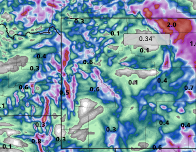
Total model forecast precipitation Monday morning through Tuesday evening.


Zoom imagery of the same area as above showing upwards of 2 plus inches 
of precipitation over the higher mountains.