Saturday, November 30, 2013

Be Prepared for A Winter Blast

The major winter blast is still on schedule for this coming week.  Snow, likely several inches in the Valley and a  foot or more in the higher elevations will precede the turn to bitter cold temperatures by mid week.  The storm is located over Alaska this Saturday morning, but will make a sharp right turn and head toward the Northern Rockies and Wyoming.

Here are a series of 500 mb charts showing the big change in pattern taking place over the next few days.

Saturday Morning Nov 30 2013
Monday Morning Dec. 2 2013


Tuesday Evening Dec. 3 2013
While the snow could be substantial, particularly in the higher elevations, the real story will be the bitter cold. By mid week, daytime temperatures will likely remain in the single digits, even in the Valley. with overnight lows dropping well below zero.  Once the cold air arrives, the snow should diminish and then end and skies could clear.  This could potentially lead to low temperatures in Star Valley dipping to minus 20 or even lower later in the week.  The pattern is expected to remain favorable for the bitter cold to remain through next weekend.
Following is a link to the lastest advisories being issued by the Riverton Forecast Office.

Thursday, November 28, 2013

Tuesday, November 26, 2013

Updated Video for Thanksgiving Weekend

Riverton Forecast Office has prepared an updated Video Briefing for weather expected over the Thanksgiving weekend and the first of next week.

Updated Holiday Weather Video

Post Thanksgiving Weekend Winter Weather Alert

While the Western States will experience a generally quiet and seasonably mild Thanksgiving Holiday Weekend,  big changes will be underway by the end of the weekend.

A major adjustment in the large scale wind pattern is now being forecast by all the computer models as a strong ridge of high pressure builds from the Northeastern Pacific into Alaska.  This will in turn lead to a very deep and cold trough into the western states by the first of the week.

This change in pattern can be seen in the forecast models of the 300mb height and winds fields and the change that occurs from mid day Friday to  mid day Tuesday December 3rd.

300 mb  forecast  noon Friday Nov.  29 2013

300 mb forecast noon Dec. 3 2013

Given that much of this forecast is 5-7 days in advance, the details, particularly precipitation are uncertain.  However, the turn to much colder is quite certain and there is the concern of snow, possibly substantial over a good part of the interior portions of the western states next week.

The Climate Prediction Center reflects this  in their 6-10 days forecast, covering the period from Monday to Friday of next week.


Note not only the relatively high degree of confidence of below temperatures in the northwestern third of the lower 48, but the unseasonably mild conditions over Alaska reflecting the strong high pressure ridge.

The Intermountain States including the Star Valley region has a high degree of confidence of above normal precipitation, in the form of snow, for the coming week.


The NWS Weather Prediction Center has attempted to show some details of the changes that are anticipated by mid day Monday.

Surface and 850 mb  forecast for Noon Monday December 2.2013

It shows the leading edge of the cold air moving across the Star Valley area accompanied by snow, with the very cold surface high pressure moving southward through Western Canada.

Friday, November 22, 2013

Thanksgiving Weather Video

Riverton WFO has issued their weekly video, discussing not only this upcoming weekends weather as well as an outlook for Thanksgiving.


Riverton WFO Weekly Video Briefing 

Cold Friday Morning


The coldest morning of the Fall occurred across Wyoming this Friday.  In Star Valley due to a lack of  development of a strong inversion due to mixing from still moderate winds aloft, subzero did not occur.  The coldest was in the Afton  area was down to around 1 above. Following is a map of observed minimums across Star Valley Friday morning.


Minimum Temperatures  November 22 2013
Elsewhere around Wyoming it was much colder in spots.  Following is a map for the lows across the Cowboy state.

Minimum Temperatures for November 22 2013

Wednesday, November 20, 2013

Much Colder on the Way

The relatively mild and moist weather the past couple of days is about to change.  A true arctic airmass is moving south to the east of the continental divide in Montana and now entering Northern Wyoming.

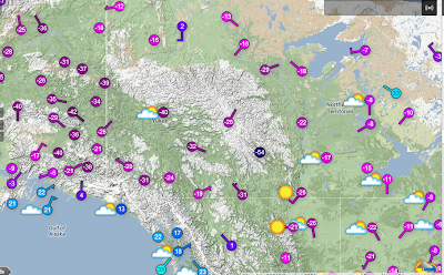
To illustrate the purity of the arctic air, following are the temperature plots from this morning from the source region, the Yukon and Northwest Territory Provinces of Canada and eastern Alaska.

Surface temperatures at 10am MDT
Notable are the -20 to -40 below zero over much of the area.  There is a station located in a sheltered valley of the Northwest Territories reporting a bone chilling -54F.

Looking further south the sub zero temperatures have spread across the border into northern Montana to the east of Glacier National Park.

Surface temperatures at 10am MST
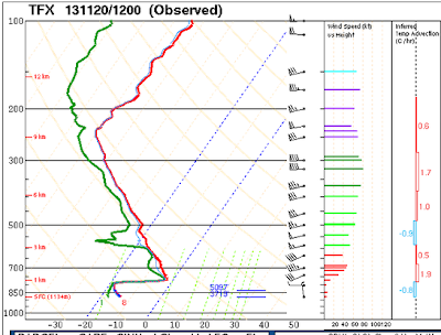
The depth of the arctic airmass is insufficient to yet spill over to the west  of the divide, thus temperatures in Western Montana still remain near or above freezing.  The depth of the arctic air can be seen in the morning upper air sounding from Great Falls Mt.


At the time of the sounding the top of the cold air was around 8000 feet MSL.  However with time as the cold air spreads southward and deepens, colder temperatures will envelop much of  Wyoming and Southeastern Idaho by Thursday night.  Following are forecasts for the 850mb temperatures, surface pressure and precipitation for the next couple of days to illustrate the southward push of the cold air on both sides of the Continental Divide.

Noon Wednesday Nov 20 2013
6am  Thursday Nov 21 2013
6am Friday Nov 22 2013
While Star Valley will likely get some snow this Wednesday afternoon and night, 1-3 inches, the colder, drier air mass will result in clearing skies and dropping temperatures Thursday and Thursday night.  By sunrise Friday it is likely the coldest parts of Star Valley will be seeing the first below zero readings of the Fall.

The weekend should be clear and continued cold with some moderation, but still near zero at night in some locations.

Monday, November 18, 2013

November 17 2013 Tornado Outbreak Summary

An unusual but not unprecedented  late season Tornado Outbreak hammered the Mid portion of the country on Sunday November 17th.  Cleanup is still underway with the death toll now up to 6 in Illinois.  Following is a plot of all severe thunderstorm events from Sunday.  A preliminary tornado total is up to 91, which will likely be consolidated once surveys are completed.


Thus far there have been two tornadoes rated as EF4, Washington IL and  New Minden IL.  Following are some photos that attest to the intensity of the tornadic winds.


Washington IL

Washington IL

Why to take shelter in lower floors  

This is evidence of another reason to live in Star Valley!

Sunday, November 17, 2013

Snowfall Totals for November 16 2012


Preliminary Snowfall Totals by County
through early Saturday evening (This will be updated with new data Sunday)
CountyLocationSnowfall
FremontSouth Pass Snotel10
FremontDeer Park Snotel9
FremontBrooks Lake Lodge6
FremontCold Springs Snotel3
FremontSt. Lawrence Alt Snotel3
FremontCastle Creek Snotel3
FremontLittle Warm Snotel1
FremontHobbs Park Snotel1
FremontTownsend Creek Snotel1
FremontAtlantic City1
CountyLocatonSnowfall
LincolnBlind Bull Summit Snotel12
LincolnWillow Creek Snotel10
LincolnSalt River Summit Snotel10
LincolnSpring Creek Divide Snotel9
LincolnCommissary Ridge9
LincolnKelley Ranger Station Snotel8
LincolnIndian Creek Snotel7
LincolnStar Valley Ranch5-6
LincolnAlpine5-6
LincolnHams Fork Snotel5
LincolnCottonwood Creek Snotel5
LincolnBlind Bull Summit5
LincolnBox Y Ranch4
Lincoln2 NE Freedom3
Lincoln2 SE Thayne2.8
LincolnSage2
LincolnAfton1.2
Lincoln3 SE Bedford1
Lincoln5 S Cokeville1
LincolnFossil Butte0.5
CountyLocationSnowfall
ParkBeartooth Lake Snotel4
ParkWolverine Snotel4
ParkBlackwater Snotel4
ParkEvening Star Snotel3
ParkKirwin Snotel3
CountyLocationSnowfall
SublettePocket Creek Snotel8
SubletteLarsen Creek Snotel8
SubletteBig Sandy Opening Snotel8
SubletteBondurant7
SubletteLoomis Park Snotel7
SubletteTriple Peak Snotel7
SubletteBondurant6
Sublette3 NW Bondurant5
SubletteKendall Ranger Station Snotel5
SubletteSnider Basin Snotel5
SubletteEast Rim Divide Snotel4
SubletteNew Fork Lake Snotel4
SubletteGunsite Pass Snotel3
SubletteElkhart Park G.S. Snotel3
Sublette14 NW Pinedale1.5
CountyLocationSnowfall
SweetwaterRock Springs0.6
CountyLocationSnowfall
TetonGrassy Lake Snotel20
TetonGrand Targhee Snotel15
TetonYellowstone South Entrance13
TetonPhillips Bench Snotel11
TetonSnake River Stn Snotel11
TetonBase Camp Snotel9
TetonJackson Hole-Rendezvous Bowl8
TetonJackson Hole-Mid8
TetonGrand Targhee-Chief Joseph7
TetonJackson Hole-Raymer7
TetonGranite Creek Snotel5
TetonJackson4
TetonJackson Hole-Base4
TetonTogwotee Pass Snotel4
Teton3 SSW Wilson4
TetonDarwin Ranch4
TetonGros Ventre Summit Snotel4
Teton1 NNW Alta4
Teton5 NW Jackson3
Teton2 NE Teton Village2
TetonMoose1
CountyLocationSnowfall
YellowstoneTwo Ocean Plateau Snotel13
YellowstoneLewis Lake Divide Snotel13
YellowstoneParker Peak Snotel10
YellowstoneThumb Divide Snotel8
YellowstoneOld Faithful Ranger Station7
YellowstoneCanyon Snotel4
YellowstoneTower Falls Ranger Station3
YellowstoneSylvan Lake Snotel1
YellowstoneSylvan Road Snotel1


Tornado Outbreak Forecast for Sunday Novermber 17th

A very strong storm moving across the Central States this weekend is expected to result in an Outbreak of Severe Thunderstorms, including possible damaging tornadoes with the High Risk area issued by the Storm Prediction Center.


The area of greatest tornado and wind damage threat follows.

Probability of tornadoes Sunday 
Probability of Damaging Winds Sunday
The stippled area above indicates the threat of strong tornadoes and very damaging winds.

Following is the discussion of the threat from the Storm Prediction Center


PUBLIC SEVERE WEATHER OUTLOOK  
   NWS STORM PREDICTION CENTER NORMAN OK
   0249 AM CST SUN NOV 17 2013

   ...SEVERE THUNDERSTORMS EXPECTED OVER PARTS OF THE MID-MISSISSIPPI
   AND OHIO VALLEYS INTO MICHIGAN TODAY THROUGH EARLY TONIGHT...

   The NWS Storm Prediction Center in Norman, Oklahoma is forecasting
   the development of a few strong, long-track tornadoes over parts of
   the Mid-Mississippi and Ohio Valleys into Michigan today through
   early tonight.

   The areas most likely to experience this activity include:

          Illinois
          Indiana
          Northern and Western Kentucky
          Lower Michigan
          Ohio
          Southeast Wisconsin

   Surrounding this greatest risk region, severe thunderstorms will
   also be possible from parts of Wisconsin, Iowa, Missouri, Arkansas,
   Mississippi, Alabama, and Tennessee northeastward across much of the
   Appalachians to the lower Great Lakes.

   A potent jet stream disturbance with wind speeds in excess of 120
   knots will sweep east across the central Plains today and across the
   Ohio Valley and northern half of the Appalachians tonight. As this
   occurs, a surface low now over the mid-Mississippi Valley will
   rapidly intensify and accelerate northeastward, reaching northern
   Michigan early tonight and western Quebec Monday morning.

   East of the low, increasingly warm and humid air at the surface will
   spread north across the Tennessee and Ohio Valleys, contributing to
   very unstable conditions over a large part of the east central
   United States. Coupled with daytime heating and ascent provided the
   jet stream impulse, the environment will become very favorable for
   severe thunderstorms --- especially along and ahead of fast-moving
   cold front trailing southward from the low into the mid-Mississippi
   and Ohio Valleys.

   Given the degree of thermodynamic instability, and the strength and
   character of the winds through the depth of the atmosphere, many of
   the storms will become supercells. Some of these will be capable of
   producing strong tornadoes --- in addition to large hail and swaths
   of damaging surface winds.  

   The storms are expected to consolidate into one or two extensive
   lines later today into tonight --- extending the threat for damaging
   winds and isolated tornadoes eastward into the Appalachians by early
   Monday.

   State and local emergency managers are monitoring this potentially
   very dangerous situation. Those in the threatened area are urged to
   review severe weather safety rules and to listen to radio,
   television, and NOAA Weather Radio for possible watches, warnings,
   and statements later today.

   ..Corfidi.. 11/17/2013
 
 
A Particularly Dangerous Tornado Watch has been issued for parts of the
below area this Sunday morning.


Thursday, November 14, 2013

Stormy Weekend

The highlight of the weekly weather video briefing out of the Riverton Forecast Office is the coming storm over the weekend including much colder.


Weekly Weather Briefing

Tuesday, November 12, 2013

Winter Returns by the Weekend

The beautiful weather that has been been dominating Star Valley and Western Wyoming the past several days will be coming to an end. The coldest air mass of the Fall will be pouring south out of western Canada by the end of the week. The ridge of high pressure that was centered over Wyoming Tuesday will rapidly weaken  with a high pressure ridge building northward off the west coast.

The system that will bring the coldest air is just entering Alaska  from Eastern Siberia. It will be  preceded by a couple weaker impulses that will cross the western states the next couple of days.
While clouds will be prevalent, the initally dry air mass will limit the snow potential until the stronger system arrives by weeks end.

Following are a series of 500mb forecast charts depicting the transition of the large scale pattern for the rest of the week.

6pm Tue 11/12/13
6pm Wed 11/13/13
6pm Thu 11/14/13
6pm Fri 11/15/13
6pm sat 11/16/13
This model brings clouds and gradually colder daytime temperatures through the remainder of the work week.  Some snow will be possible by Thursday and Friday with the passage of the upper systems. Then more serious snow potential and much colder air will arrive over the weekend  Too early to forecast the amount of snow as the system that will be the primary source has yet to even  enter Alaska as of Tuesday  evening. However temperatures will remain well below freezing over the weekend with potentially nighttime readings dropping to single digits Sunday night.

Sunday, November 10, 2013

Tacloban, Philipinnes after passage of Typhoon Haiyan

Eye of Super Typhoon Haiyan approaching Tacloban. Philippines
Probably the strongest Typhoon/Hurricane of modern times just as the eye and its 30 foot storm surge were crossing the coast near Tacloban, Phiippines(black X).  Winds were estimated, sustained to 190 MPH with gust to 230 MPH!

Following is a video taken in Tacloban as survivors began to recover.

Video of Tacloban after the passage of Typhoon Haiyan

Thursday, November 7, 2013

The Eye of Haiyan


An amazing video of the visual eye of Super Typhoon Haiyan as it moves toward the Philippine Islands


Visible Movie of Haiyan

Warmer and Drier Weather Ahead

After a stormy and snow first week of November, it now appears that a pattern change to warmer and drier weather  is in store for next week.  Riverton Forecast Office summarizes this well in their weekly weather briefing.


Riverton Video Weather Briefing 

Catastrophic Damage Expected in Philippines with Super Typhoon Haiyan

Water Vapor Image of  Typhoon Haiyan


Super Typhoon  Haiyan is now rated as one of the most intense ever observed.

It will impact the Philippines within the next 24 hours and will create tremendous damage and potential loss of life.  Jeff Masters of Weather Underground has blogged Typhoon Haiyan.


Super Typhoon Haiyan Blog


Tuesday, November 5, 2013

Overnight Snow and Winter Cold


Overnight, Star Valley Ranch reported 7 inches of new snow with close to 10 inches on the ground.  Low temperatures this morning across Star Valley ranged from 15 at Star Valley Ranch down to 6 above at the Cakebread weather station which is located about 3 miles north of Thayne.  Thayne ES dipped to 8 above as did the Smoot station.