Following is the link to the Weather Summary through the weekend ahead, prepared by the Riverton Forecast Office.
Weekly Weather Video
A BLOG ABOUT WEATHER FORECASTING AND OBSERVING AS IT RELATES TO STAR VALLEY, WYOMING IN PARTICULAR
Thursday, May 30, 2013
Sunday, May 26, 2013
Snow?
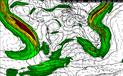
Memorial Day will see the beginning of a change in the weather for Star Valley, leading to a rather unsettled week ahead. An unseasonably strong jet stream will be shifting eastward from the Pacific Ocean across the western states. This will bring a turn to colder and wetter for much of the area from Idaho/Wyoming northward.
Here is a series of forecast charts for the 250 mb level(jet stream level) depicting this change.
The strong jet moves from the Pacific and by mid week has resulted in a large trough centered over Wyoming, bringing with it much cooler air and several periods of showers and thundershowers. These will first show up mainly to the north and west of Wyoming on Monday as the air mass gradually moistens and begins to cool. Tuesday and Wednesday will see more widespread showers as the upper trough develops and the jet stream crosses the Western states to the south of Wyoming.
Here are a series of surface charts and model forecast precipitation.
It is quite apparent that precipitation will affect a wide area surrounding Wyoming this coming week. The total precipitation forecast by the NWS for the next 5 days includes significant amounts as far south as western Wyoming, with a very wet week in store from Montana eastward into the Plains.
There is no doubt it will be cold enough for snow in the higher elevations of western Wyoming by mid week, with possible significant totals above 8-9000 feet. A mixture of rain and snow is possible as low as the floor of Star Valley by mid-week during the overnight and morning hours. However any real accumulations are not expected at this time.
Travel into higher elevations such as Yellowstone NP, Wind Rivers and across the recently opened Bear Tooth Pass could definitely be impacted later this week.
Here is a series of forecast charts for the 250 mb level(jet stream level) depicting this change.
 |
| Sunday evening 5/26/13 |
 |
| Monday evening 5/27/13 |
 |
| Tuesday evening 5/28/13 |
 |
| Wednesday evening 5/29/13 |
 |
| Thursday evening 5/30/13 |
Here are a series of surface charts and model forecast precipitation.
 |
| Monday evening 5/27/13 |
 |
| Tuesday evening 5/28/13 |
 |
| Wednesday evening 5/29/13 |
 |
| Thursday evening 5/30/13 |
 |
| Total precipitation expected from Sunday to Friday of this week. |
Travel into higher elevations such as Yellowstone NP, Wind Rivers and across the recently opened Bear Tooth Pass could definitely be impacted later this week.
Friday, May 24, 2013
Memorial Weekend Looking Good
Here is the weekly weather briefing prepared and provided by the Riverton Forecast Office.
Memorial Weekend Weather Briefing
Memorial Weekend Weather Briefing
Wednesday, May 22, 2013
Moore Tornado discussed by Dr. Jim Steenburg U of U and Dr. Jeff Masters U of W
There are two excellent blogs on the EF5 Moore tornado. I have linked to their post for those interested in an insightful discussion on the Tornado and its development
Jim Steenburgs Moore Tornado Discussion
Jeff Masters Moore Tornado Discussion
Jim Steenburgs Moore Tornado Discussion
Jeff Masters Moore Tornado Discussion
Rainfall Summary for the Period May 15-20
Rain Returns to the Cowboy State
Showers and some thunderstorms have brought much needed rain to Western and Central Wyoming last Wednesday night (May 15th) through this past Monday (May 20th). The table below reflects final rainfall totals.
The following are Rainfall totals for the period May 15-20.
The following are Rainfall totals for the period May 15-20.
| County | Station Name | Rainfall |
|---|
| Lincoln | Afton | 1.77 |
| Lincoln | 3 SE Bedford | 1.73 |
| Lincoln | Star Valley Ranch | 1.70 |
| Lincoln | 5 SSE Smoot | 1.56 |
| Lincoln | 1 SW Afton | 0.70 |
| Lincoln | Fossil Butte | 0.48 |
| Lincoln | 21 NNW Kemmerer | 0.29 |
| Big Horn | 2 SSW Lovell | 0.51 |
| Big Horn | Greybull | 0.43 |
| Big Horn | Greybull/South Big Horn Air | 0.38 |
| Big Horn | Shell | 0.33 |
| Fremont | Jeffrey City | 1.74 |
| Fremont | 6 SW Lander | 1.58 |
| Fremont | Lander | 1.29 |
| Fremont | Lander Airport | 1.27 |
| Fremont | 9 SSE Lander | 1.23 |
| Fremont | Lander | 1.16 |
| Fremont | Hudson | 1.17 |
| Fremont | 10 WNW Dubois | 0.92 |
| Fremont | 6 SE Lander | 0.90 |
| Fremont | Riverton Downtown | 0.83 |
| Fremont | Riverton Airport | 0.79 |
| Fremont | 2 N Lander | 0.68 |
| Fremont | Burris | 0.63 |
| Fremont | Dubois | 0.40 |
| Fremont | Boysen Dam | 0.31 |
| Fremont | 1 WSW Lander | 0.18 |
| Hot Springs | 1 SW Thermopolis | 1.11 |
| Hot Springs | 9 NE Thermopolis | 0.99 |
| Hot Springs | Thermopolis | 1.46 |
| Hot Springs | Kirby | 1.23 |
| Hot Springs | Thermopolis | 0.96 |
| Johnson | Buffalo Airport | 1.04 |
| Johnson | 20 S Buffalo | 0.93 |
| Johnson | Billy Creek | 0.82 |
| Johnson | 17 NNW Kaycee | 0.61 |
| Johnson | 4 SSW Buffalo | 0.66 |
| Johnson | Buffalo | 0.67 |
| Johnson | Buffalo | 0.43 |
| Johnson | 17 E Kaycee | 0.07 |
| Natrona | 3 SW Casper | 3.96 |
| Natrona | 4 WSW Casper | 2.55 |
| Natrona | 2 S Casper | 2.60 |
| Natrona | 1 SW Casper | 2.39 |
| Natrona | 4 WSW Casper | 2.28 |
| Natrona | 4 SW Casper | 2.22 |
| Natrona | 11 ESE Casper | 2.05 |
| Natrona | Casper Near Airport | 1.56 |
| Natrona | Casper Airport | 1.58 |
| Natrona | 10 WSW Casper | 1.36 |
| Natrona | 11 WSW Casper | 1.34 |
| Natrona | Midwest | 1.02 |
| Natrona | Casper | 2.45 |
| Natrona | 12 NE Lysite | 0.21 |
| Natrona | Casper | 1.09 |
| Park | Cody Area | 1.42 - 1.89 |
| Park | 3 NE Sunshine | 1.85 |
| Park | 3 NE Clark | 1.56 |
| Park | Powell Area | 0.86 - 1.20 |
| Park | Crandall Creek | 1.02 |
| Park | Meeteetse | 0.85 |
| Sublette | Daniel Fish Hatchery | 0.76 |
| Sublette | 14 NW Pinedale | 0.44 |
| Sublette | 13 SE Pinedale | 0.48 |
| Sublette | Boulder Rearing Station | 0.33 |
| Sublette | Big Piney Airport | 0.25 |
| Sweetwater | 1 W Rock Springs | 1.06 |
| Sweetwater | 1 E Rock Springs | 1.06 |
| Sweetwater | 7 SSE Rock Springs | 0.91 |
| Sweetwater | Green River | 1.00 |
| Sweetwater | 38 NW Superior | 1.00 |
| Sweetwater | 5 N Farson | 0.85 |
| Sweetwater | Rock Springs Airport | 0.36 |
| Sweetwater | Buckboard Marina | 0.19 |
| Sweetwater | 1 S Rock Springs | 0.29 |
| Teton | 5 WNW Moran | 1.09 |
| Teton | 4 SSW Jackson | 0.82 |
| Teton | Moose | 0.77 |
| Teton | 2 NE Teton Village | 0.75 |
| Teton | Jackson | 0.74 |
| Teton | Moose | 0.67 |
| Teton | 3 WNW Jackson | 0.31 |
| Washakie | 16 SSE Ten Sleep | 0.66 |
| Washakie | 8 SW Worland | 0.48 |
| Washakie | 5 NNW Ten Sleep | 0.39 |
| Washakie | Worland ASOS | 0.35 |
| Yellowstone | Snake River Ranger Station | 1.53 |
| Yellowstone | Lake Yellowstone | 1.07 |
| Yellowstone | Old Faithful Ranger Station | 1.03 |
| Yellowstone | Tower Falls Ranger Station | 0.79 |
| Yellowstone | Yellowstone East Entrance | 0.47 |
| Yellowstone | Lamar Ranger Station | 0.57 |
Tuesday, May 21, 2013
Moore Oklahoma Tornado
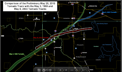
A devastating EF5 tornado struck Moore Oklahoma the afternoon of May 20, 2013. There has been extensive media coverage including videos etc. This post will provide a look at the radar data that was used to provide the life-saving warnings.
Following is the path of the EF5 tornado along with the additional two devastating tornado paths that have struck the Moore community in the past 14 years.
 |
| Tracks of 3 major tornados that have hit Moore OK since 1999. |
The velocity image on the right shows the intense velocity couplet, while the reflectivity image on the left shows the huge debris ball about the time the tornado was destroying the Plaza Towers Elementary School.
Here is a link that will provide a time lapse of both the velocity and reflectivity of the storms as it track from Newcastle eastward across Moore OK.
Radar animation of the Twin Lakes 88-D radar
The official statement issued by the Norman Forecast Office Tuesday follows
Public Information Statement Issued by NWS Norman
for the Tornado Outbreak of May 20, 2013
PUBLIC INFORMATION STATEMENT
NATIONAL WEATHER SERVICE NORMAN OK
250 PM CDT TUE MAY 21 2013

...NWS DAMAGE SURVEY FOR 5/20/2013 NEWCASTLE/MOORE TORNADO EVENT -
UPDATE 3...

...NWS DAMAGE SURVEY HAS NOW RATED THE NEWCASTLE/MOORE TORNADO AS EF5...

.OVERVIEW...

THE NATIONAL WEATHER SERVICE DISPATCHED FOUR DAMAGE SURVEY TEAMS TO
THE PATH OF THE NEWCASTLE/MOORE OK TORNADO. NEW STATEMENTS WILL BE
ISSUED THROUGHOUT THE DAY AS THESE TEAMS REPORT FINDINGS. THIS
INFORMATION REMAINS PRELIMINARY AND THE INFORMATION HERE COULD
CHANGE.

.NEWCASTLE/MOORE TORNADO

RATING:                  EF5
ESTIMATED PEAK WIND:     200-210 MPH
PATH LENGTH /STATUTE/:   17 MILES
PATH WIDTH /MAXIMUM/:    1.3 MILES
FATALITIES:              N/A
INJURIES:                N/A

START DATE:              MAY 20 2013
START TIME:              2:45 PM CDT
START LOCATION:          4.4 W  NEWCASTLE /GRADY COUNTY /OK
START LAT/LON:           35.2580 / -97.6775

END DATE:                MAY 20 2013
END TIME:                3:35 PM CDT
END LOCATION:            4.8 E OF MOORE OK /CLEVELAND COUNTY /OK
END LAT/LON:             35.3409 / -97.4007

SURVEY SUMMARY: EXPERTS SURVEYING IN MOORE HAVE DETERMINED DAMAGE IS
EF5 WITH MAXIMUM WINDS OVER 200 MPH. FOUR SURVEY TEAMS CONTINUE TO
INSPECT DAMAGE FROM THIS LONG TRACK TORNADO. INITIAL DAMAGE WAS
FOUND AROUND 4.4 MILES WEST OF NEWCASTLE...SOUTH OF TECUMSEH ROAD
ALSO KNOWN AS NW 16TH STREET AND EAST LAKE ROAD. THE TORNADO TRACKED
NE TO THE INTERSTATE 44 BRIDGE OVER THE CANADIAN RIVER AND THEN TOOK
A MORE EASTWARD TRACK THROUGH MOORE. TORNADO DAMAGE ABRUPTLY ENDS
0.3 MILES EAST OF AIR DEPOT ROAD AND N OF SE 134TH ST.

INITIALLY PRODUCING EF0 AND EF1 DAMAGE THE STORM INTENSIFIED VERY
RAPIDLY IN 4 MILES OR AROUND 10 MINUTES PRODUCING EF4 DAMAGE BEFORE
REACHING INTERSTATE 44. NUMEROUS INDICATIONS OF EF4 DAMAGE WITH SOME
AREAS NOW DETERMINED AT EF5 DAMAGE...THE HIGHEST CATEGORY ON THE EF
SCALE...WITH OVER 200 MPH WINDS.

ADDITIONAL INFORMATION SUCH AS MAXIMUM PATH WIDTH WILL BE UPDATED
AS THE TEAMS COMPLETE THEIR SURVEYS.
|
Thursday, May 16, 2013
Funnel Cloud Star Valley?
This photo was taken at 5:15pm Thursday looking west at the intersection of Highway 89 and Cedar Road near Star Valley Ranch. Little if any rotation was observed and it dissipated shortly after photo.
2013 Spotter Training Thursday May 16th
The annual SpotterTraining conducted by the Riverton Forecast Office is being presented in Afton at the Civic Center today, Thursday May 16th at 6PM. It is an excellent presentation on how to identify Severe Thunderstorms.
 |
| Supercell Thunderstorm |
 |
| Supercell Thunderstorm |
| ||
| Severe Weather Spotter Talk Schedule |
Below is a listing of upcoming severe weather spotter talks...
| May, 2013 - Upcoming | |||
| Day | City, State | Time | Location |
| 16 | Afton, WY (Lincoln County) | 6:00pm MDT | Civic Center 150 South Washington |
| Contact Information: Bill.Murrell@noaa.gov | |||
| 21 | Lander, WY (Fremont County) | 6:00pm MDT | BLM, 1335 Main Street |
| Contact Information: katy.branham@noaa.gov | |||
| 23 | Big Piney, WY (Sublette County) | 6:00pm MDT | Big Piney/Marbleton Fire Hall, 203 Main Street in Marbleton |
| Contact Information: Bill.Murrell@noaa.gov | |||
Wednesday, May 15, 2013
4,0 Earthquake Rocks Star Valley
An earthquake occurred around 11:23 PM MDT just to the west of Star Valley. The preliminary strength from the USGS was magnitude 4.0 on the Richter Scale. The epicenter was about 10 miles WNW of Afton WY. It was felt at Star Valley Ranch with two sharp jolts.
Sunday, May 12, 2013
Near Record Warmth on Monday will speed up Snow Melt
Temperatures in Star Valley will likely reach into the low 80's on Monday after a perfect Mothers Day Sunday with 70's. At Star Valley Ranch the warmth has quickly pushed the Aspens into leafing out the past couple of days.
A warm ridge of high pressure is forecasted to be over Wyoming on Monday, May 13. This will result in possible record high temperatures across much of the area. | |||
| Sunday, May 12, 2013 | |||
| Location | Forecasted High Temperature °F | Current Record Temperature °F / Year | |
| Casper - Natrona County International Airport | 79 | 87 / 1960 | |
| Lander - Hunt Field | 79 | 86 / 1960 | |
| Riverton - Downtown | 80 | 89 / 1962 | |
| Rock Springs - Sweetwater County Municipal Airport | 77 | 82 / 1960 | |
| Worland - Municipal Airport | 83 | 92 / 1960 | |
| Monday, May 13, 2013 | |||
| Location | Forecasted High Temperature °F | Current Record Temperature °F / Year | |
| Casper - Natrona County International Airport | 87 | 87 / 2001 | |
| Lander - Hunt Field | 85 | 86 / 2001, 1988 | |
| Riverton - Downtown | 86 | 88 / 2007 | |
| Rock Springs - Sweetwater County Municipal Airport | 81 | 80 / 1996 | |
| Worland - Municipal Airport | 90 | 92 / 2001 | |
Also of concern heading into Monday will be rising water levels in some of the area rivers/creeks. Temperatures will be rising consecutively over the weekend, so increased snowmelt is expected. The Spring Snowmelt Flood Potential Outlook in addition to the latestWater Supply Outlook, will help identify those areas that may be more susceptible for these expected water rises.
Thursday, May 9, 2013
Summer Like Temperatures by Monday?
The video briefing for the next several days promises temperatures rising to near summer like levels by Monday!.
Weather Briefing From Riverton WFO
Weather Briefing From Riverton WFO
Monday, May 6, 2013
Spring Snowstorms Come Through for Wyoming
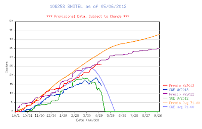
It has been a very beneficial Spring snow season for all of Wyoming this year. At Star Valley Ranch the total of 172 inches since October 1, 2012 compares closely with last years 175 inches.
Of more importance are the snow pack in the mountains which are just now beginning the melting process as temperatures warm. Following are the graphs for both the Willow Creek and Cottonwood Creek SNOTELS in the nearby Salt Range.
While western Wyoming has fared well the eastern portion of the state has show remarkable improvements due to several big storms, particularly in April.
Following are two maps, the first the snow pack as of March 1st and the other, May 1st. The improvements in the eastern portion of the state are dramatic!
Of more importance are the snow pack in the mountains which are just now beginning the melting process as temperatures warm. Following are the graphs for both the Willow Creek and Cottonwood Creek SNOTELS in the nearby Salt Range.
 |
| Willow Creek SNOTEL |
 |
| Cottonwood Creek SNOTEL |
Following are two maps, the first the snow pack as of March 1st and the other, May 1st. The improvements in the eastern portion of the state are dramatic!
Thursday, May 2, 2013
Weekend Weather Briefing and Storm Summary
Riverton WFO is providing their weekly briefing of the upcoming weekends weather. It can accessed through the following link
Weekly Video Weather
Additionally Riverton WFO has issued a summary of the most recent storm that affected the Cowboy State.
Summary of the May Snow storm
Weekly Video Weather
Additionally Riverton WFO has issued a summary of the most recent storm that affected the Cowboy State.
Summary of the May Snow storm
Subscribe to:
Comments (Atom)


