Sunday, July 29, 2012

Dry Summer?

With July almost in the books, it is a good time to evaluate how Star Valley has fared with precipitation thus far. First it is of interest to take a look at the big picture as to the United States as a whole.  The media has certainly been playing up how dry it has been,  particularly in the central states.  The first figure will show the precipitation since around the first of June.
Total rainfall  May 29-July 29 2012
 Indeed it has been quite dry with the exception of the Pacific Northwest and far Northern Rockies, as well as some areas along the Atlantic and Gulf  Coast. The next map will show the percentage of normal for the same 60 day time period.

Percent of Normal Rainfall for May 29- July 29 2012
 

The drought conditions are quite obvious  in the Plains states as well as many areas of the west.  Large sections of the corn belt has received less than 25 percent of normal, which will have a major impact on the harvest this fall.

Looking at Wyoming and particularly Star Valley for the past 60 days ending July 29th it has also been a dry summer thus far.

Rainfall May 29- July 29 2012

Large portions of western Wyoming have had less than an inch of precipitation with southern Lincoln county hardly none.

Comparing with the normal for the same time period

Percentage of normal May 29-July 29 2012

Less than half the normal amount has fallen over much of western Wyoming including Star Valley.

Here are some totals observed around Star Valley since June 1, 2012

Star Valley Ranch           1.95
2 NE Etna                       1.39 
Alpine                             1.37
Thayne                            1.35
1.5 SE Thayne                1.23   
7 S Smoot                       1.19
Smoot                                .91
Etna                                   .84

The normal amount that can be expected to fall in the two month period is around 3 inches.  Most of the Valley has received less than half of normal.

Thus far in 2012 here is an image of the total precipitation along with the comparison with the normal.


Hopefully as we go into the Fall months the pattern will change and allow the storm track to shift south  to across Wyoming.

Thursday, July 19, 2012

Monsoon Update

Now that the latest surge of Monsoon moisture has departed Western Wyoming  Riverton WFO has produced a rainfall summary of the past week.

Rainfall July 10-17 2012


http://www.crh.noaa.gov/news/display_cmsstory.php?wfo=riw&storyid=85499&source=0

Star Valley received anywhere from a half inch to an inch and a half in several periods of showers.  It provided substantial relief from what has been a very warm and dry summer thus far.

The air mass has dried out again but it appears that monsoonal moisture could make another visit to the area by this weekend.  The upper air pattern continues to be dominated by a large high pressure over the central states where they are suffering under drought conditions and near record heat.

Thursday AM 500 MB Analysis

Over the next couple of days the upper high becomes even stronger while the persistent low now near the northern California coast moves northeastward into Canada.

Saturday PM 500 MB forecast

This pattern assures that Star Valley will stay warm and the only question is will we be favored with showers and thunderstorms from a return on the monsoon moisture.

This mornings infrared and water vapor satellite imagery suggest that may already be taking place.
Infrared Imagery Thursday AM 7/19/12

Water Vapor Thursday AM 7/19/12
A feed of mainly higher level cloudiness is now spreading northward through Utah as can be seen on this mornings visible imagery

Visible Imagery 9 AM MDT 7/19/12
This mornings Flagstaff  upper air sounding still show a lack of low level moisture, but plenty above about 15,000 ft MSL heading north toward Star Valley.

Flagstaff Sounding Thursday AM 7/19/12


While high clouds will begin increasing Thursday afternoon over Star Valley, chances of thunderstorms will likely not appear until Friday.  Initially storms that develop will contain only small amounts of rain, but gusty winds will be likely as the afternoon temperatures will be very warm.

Over the weekend with moisture continuing to increase, the chances of more substantial showers will be possible.  However temperatures will continue very warm in the afternoon with highs near 90 F in the Valley.

Thursday, July 12, 2012

Pattern Change

The Numerical models are all in agreement that the upper high pressure that has been in control  over Star Valley for several days is giving way to a trough of low pressure over the western states.  This will lead to the potential of the first significant precipitation for Western Wyoming and Southeastern Idaho since May.

There are two important features that show up on the water vapor satellite imagery this Thursday morning.

Water Vapor Imagery Thursday AM  7/12/12
The pronounced low pressure circulation off the Pacific Northwest coast, which will lead to the trough over the western states.  Of even more importance is the large area of moisture over the desert Southwest.

The precipitable water analysis for this same time shows the very moist monsoon air now moving northward into the deserts from Mexico.

Precipitable Water Thursday AM 7/12/12
Upwards of 2 inches  has moved into the Lower Colorado River Valley,
By Saturday morning the trough of low pressure is located over the west with a southerly flow bringing the large amount of moisture northward across Star Valley.

500 mb forecast Saturday an 7/14/12
The models are forecasting a large area of precipitation to spread  northward across Star Valley in the form of showers and thundershowers. 

48 hour forecasted rainfall through Sunday AM 7/15/12  

As always with summer time precipitation their will be large variability as to how much any one location receives.  But the pattern and available moisture suggests that the potential of substantial amounts are possible.  Rainfall totals could range upwards to an inch in more favored locations.

Wednesday, July 11, 2012

Teton Tornado 25 Years Ago

This month marks the 25th  anniversary of the infamous Teton Tornado.  Up until July 21, 1987  a violent tornado( F4-F5) had never been observed in the United States west of the Continental Divide or at higher elevations.  Following is the Wikepedia description of the Teton Tornado.

The Teton–Yellowstone tornado was a rare high-altitude tornado which occurred on July 21, 1987 in the U.S. State of Wyoming. Rated at F4 on the Fujita scale, it was the strongest tornado ever recorded in the state. The tornado cut through a 24-mile (39 km) long, 1.5-mile (2.4 km) wide swath of the Teton Wilderness and Yellowstone National Park, and even crossed the Continental Divide. The damage occurred at elevations ranging from 8,500 to 10,000 feet (2,600 to 3,000 m), making it the highest altitude violent tornado recorded in the United States. No human fatalities or injuries were recorded, but up to 1,000,000 trees were uprooted by the storm. Most of the damaged forest later burned in the Yellowstone fires of 1988.

Following is an aerial photograph  of some of trees that were blown down covering the Enos Lake trail.


The Google Maps image below outlines the approximate path of the Teton tornado which crossed Enos Lake.


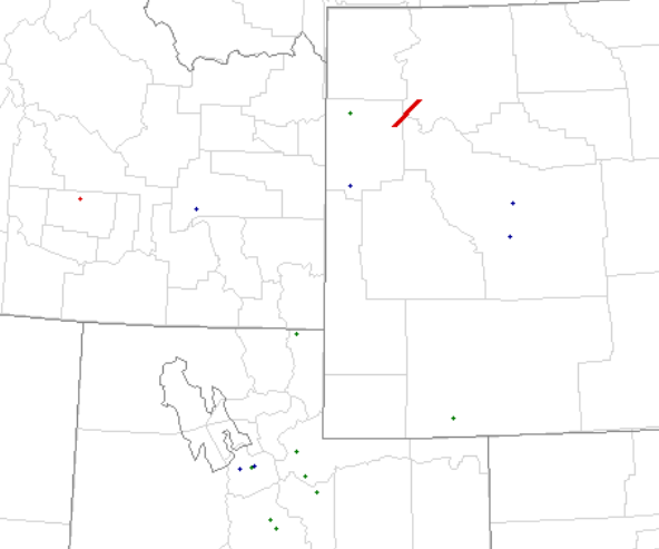
A plot of the severe reports for the day not only indicate the path of the Teton tornado but several hail reports upstream across Northern Utah.


Severe Thunderstorm Events July 21 1987

The Salt Lake Valley experienced damaging hail up to 2 inches in diameter about two to three hours prior to the Teton tornado.    


Twenty five years ago was before good radar data, including any Doppler capabilities  However, the supercell that produced the Teton tornado very likely initially developed over Northern Utah where the large hail occurred and then moved rapidly under strong southwesterly flow into western Wyoming.

Here is a link to the publication by Dr. Fujita on the Teton Tornado.

http://journals.ametsoc.org/doi/abs/10.1175/1520-0493%281989%29117%3C1913%3ATTYTOJ%3E2.0.CO%3B2 

The actual aerial survey was conducted by Brian Smith currently the Warning Coordination Meteorologist at the Omaha Weather Forecast Office.

Friday, July 6, 2012

Typical Summer Weather

Now that the long dry period has been broken by a strong surge of Monsoon moisture from the south, it appears Star Valley and surrounding areas will experience more typical mid summer weather.

Although rainfall amounts from Thursdays showers were not great, generally around .2 of an inch, the air mass has moistened up considerably over what has been the case for about the last month.

The disturbance that accompanied the moist surge has moved on and over the next several days a large upper high will develop over this part of the country and dominate through the middle of the month.

Following is a sequence of 500mb charts showing this trend,

500 MB analysis Friday AM July 6 2012

500 MB forecast Sunday AM July 8 2012

500 MB forecast Tuesday AM July 10 2012


500MB forecast Thursday July 12 2012

 With the moisture now in the area, the strong daytime heating under the upper high will trigger afternoon and evening showers and thunderstorms.  Rainfall will be spotty with the storms and be mainly over and near the higher mountains. 

Temperatures will be warm with 80s and even low 90s in Star Valley.  However nights will see temperatures dropping into the 40s and low 50s. 

The general precipitation that fell Thursday aided the fire fighters on the Fontenelle Fire.  However concern remains as warmer and drier days are likely into next week.

There is an excellent web site to monitor the fire situation..

http://www.inciweb.org/incident/2934/