Sunday, January 29, 2012

New Month to Begin Very Quiet After Early Week Snow

Once again as has happened a couple times already this winter, it appears that Star Valley will experience a prolonged period of snow free days in early February.  For the beginning of the coming work week, a series of relatively weak disturbances will bring periods of mostly light snow to the area.  The Water Vapor imagery Sunday evening shows the first system now moving onshore in the Pacific Northwest followed closely by a 2nd  and even 3rd system.

GOES Water Vapor Imagery Sunday evening 1/29/12

The first system should spread snow across much of Star Valley beginning by early Monday afternoon.  Amounts should be greatest in the surrounding mountains with a couple inches possible in the Valley by evening.

The next weaker disturbance will likely continue a threat of at least some light snow going into Tuesday with a possible overnight break between systems.

The major change in the pattern will begin by mid week as an upper ridge of high pressure builds strongly into the Western States and then dominates our region at least through the coming weekend. As seen in the model forecast for this coming Wednesday evening one last upper level low pressure wave will be moving toward Star Valley as the strong upper ridge builds toward the West Coast.


500 mb level forecast for Wednesday evening 2/1/2012

The threat of light snow will persist across Star Valley until this final upper trough moves southeast of our area by Thursday morning.  Total snowfall for the period Monday afternoon until Wednesday night could add up to 2-4 inches in the Valley with upwards of a foot in favorable nearby mountain locations.

Then the strong ridge of high pressure builds across much of the northwestern States and shuts down the active weather for an extended period.  The 500 mb forecast for next Sunday strongly supports this idea of no snow after about Wednesday night for an extended period.
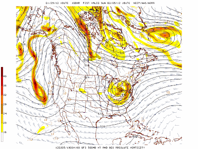

500 mb Forecast Sunday 2/5/2012

With this type of pattern the sensible weather in Star Valley will be dominated by strong nighttime inversions which will have a difficult time dissipating in the afternoon as the sun angle is still too low.  Result will be minimums on the valley floor dropping to near or below zero with afternoon highs in the probably not rising to freezing.  This will result in rather marked differences with those areas that remain above the inversion, such as the mountainous regions and higher valley locations such as Star Valley Ranch and the far end of the Valley south of Smoot where elevations are near 7000 feet.  Here daytime maximums should be well above freezing and remain above zero at night. 

The higher sun angle the first week in February compared to the extended stagnation period experienced in December should be a little more effective in daytime warming keeping temperatures above the cold ones in December. 


Thursday, January 26, 2012

Excellent Weekend Ahead

About 6 hours of snow will accompany a fast moving upper trough and strong jet stream Thursday afternoon and evening across Star Valley.  It should add another 2-4 inches to the current snow pack.  While flurries could continue through the night, high pressure and a drier northwesterly flow will lead to one of the better weekends of the Winter.  With several inches of new snow on the now substantial snow-pack, outdoor winter sports should be enjoyed under lots of sunshine, particularly Saturday.

The next system will be approaching Star Valley later Sunday into the first of next week.  Thus clouds could be on the increase Sunday, however, any new snow should hold off until Sunday night or Monday.

With the clearing skies, overnight temperatures will drop to around zero or below Saturday and again Sunday morning.  Inversions will likely develop and keep the valley locations well below freezing. However, winds will be light and sunshine abundant, particularly on Saturday.

 The long range forecast models continue to bring air off the Pacific into Star Valley, rather than out of the Arctic regions of  Northern Canada. Bitterly cold air should not be a threat to this area for the foreseeable future.

The latest extended temperature and precipitation forecasts from the Climate Prediction Center certainly support this idea.

Temperature Forecast Feb 2-9 2012


Precipitation Forecast Feb 2-9 2012

Monday, January 23, 2012

Weekend Storm, the Good and the Bad

The weather system which resulted in the large amounts of snow and even rain in Star Valley at the end of last week, provided the energy for a Mid Winter tornado outbreak in the southern states late Sunday and early Monday.


There were reports of a couple dozen tornados with the most deadly occurring in the early morning hours in central Alabama.  These tornados were generated by intense supercell thunderstorms.  Following are a couple images from early Monday morning of both the reflectivity and velocities detected  from the Birmingham Al Doppler radar.

Radar images at 5:05 am CDT 1/23/12
The top image shows a classic hook signature with an associated very tight velocity couplet on the bottom.

There were reports of at least 2 fatalities and over 100 injured with these early morning storms in Alabama.

A much more positive result from the same storm system was the culmination of a very wet week in Star Valley. Below is a figure showing the dramatic improvement in the snow pack in the Salt Range at the Willow Creek Snotel site.

This brings the snowpack almost up to normal after such a poor start to the winter season.


The same storm brought copious amounts of rain and snow to nearby Salt Lake City area.  While the snow was very beneficial in the mountains, hazardous driving conditions resulted from the heavy snow on the hilly roads in Bountiful Utah. The attached video attests to this!


Saturday, January 21, 2012

Snow Totals As of Friday PM

While another storm has dumped additional very wet snow mixed with rain on Star Valley Saturday, Riverton WFO has provided an excellent summary of the snow totals across Western Wyoming through Friday afternoon.  Below is a listing of locations by County.

County Station Name Snowfall
Big Horn Bone Springs Divide Snotel 14
Big Horn Shell Creek Snotel 9
Big Horn Bald Mountain Snotel 6
Fremont Burroughs Creek Snotel 34
Fremont South Pass Snotel 21
Fremont Castle Creek Snotel 21
Fremont Brooks Lake Lodge 19
Fremont Cold Springs Snotel 12
Fremont Hobbs Park Snotel 10
Fremont Little Warm Snotel 9
Fremont Deer Park Snotel 9
Fremont Townsend Creek Snotel 7
Fremont St. Lawrence Alt Snotel 3
Fremont Dubois 1.5
Hot Springs Owl Creek Snotel 9
Johnson Cloud Peak Reservoir Snotel 13
Johnson Soldier Park Snotel 12
Johnson Little Goose Snotel 9
Johnson Hansen Sawmill Snotel 9
Johnson Bear Trap Meadow Snotel 3
Lincoln Blind Bull Summit Snotel 54
Lincoln Willow Creek Snotel 49
Lincoln Indian Creek Snotel 44
Lincoln Spring Creek Divide Snotel 43
Lincoln Cottonwood Creek Snotel 35
Lincoln Kelley Ranger Station Snotel 32
Lincoln Salt River Summit Snotel 28
Lincoln Blind Bull Summit 26
Lincoln Box Y Ranch 24
Lincoln Hams Fork Snotel 22
Lincoln 5 NNE Thayne 19
Lincoln Alpine 18
Lincoln 1 SE Thayne 14
Lincoln 5 SSE Smoot 14
Lincoln 3 SE Bedford 13
Lincoln Star Valley Ranch 13
Lincoln 1 W Smoot 8.5
Lincoln Afton 6 to 8
Lincoln Kemmerer 3.5
Lincoln 1 SW Kemmerer 1
Lincoln Afton 0.5
Lincoln La Barge 0.3
Natrona Grave Spring Snotel 6
Park Evening Star Snotel 38
Park Beartooth Lake Snotel 35
Park Younts Peak Snotel 31
Park Blackwater Snotel 30
Park Wolverine Snotel 21
Park Kirwin Snotel 16
Park Pahaska 13
Park Marquette Snotel 8
Park 2 WSW Cody 1
Park 1 WNW Cody 0.8
Park 4 SE Cody 0.3
Park Lamar Ranger Station 0.2
Park 5 ESE Cody 0.2
Sublette Triple Peak Snotel 43
Sublette Kendall Ranger Station Snotel 39
Sublette 3 NW Bondurant 34
Sublette Larsen Creek Snotel 33
Sublette Big Sandy Opening Snotel 33
Sublette Loomis Park Snotel 32
Sublette Pocket Creek Snotel 28
Sublette East Rim Divide Snotel 26
Sublette New Fork Lake Snotel 26
Sublette Elkhart Park G.S. Snotel 25
Sublette Bondurant 24.6
Sublette Gunsite Pass Snotel 23
Sublette Snider Basin Snotel 21
Sublette Merna 14
Sublette 14 NW Pinedale 9.6
Sublette Cora 9
Sublette Daniel Fish Hatchery 6.5
Sublette Pinedale 6
Sublette 13 SE Pinedale 2.6
Sublette Boulder Rearing Station 1
Sublette Pinedale 1
Teton Grassy Lake Snotel 72
Teton Phillips Bench Snotel 59
Teton Jackson Hole-Rendezvous Bowl 45
Teton Base Camp Snotel 44
Teton Grand Targhee Snotel 42
Teton Snake River Station Snotel 37
Teton Togwotee Pass Snotel 33
Teton Granite Creek Snotel 33
Teton Jackson Hole-Raymer 31
Teton Snow King Ski Area 29
Teton Jackson Hole-Mid 28
Teton 3 SSW Wilson 28
Teton Grand Targhee Ski Area 25
Teton 5N Hoback Junction 24
Teton 6 S Jackson 24
Teton Togwotee 22
Teton 2 SW Teton Village 21
Teton 4 SSW Jackson 19.4
Teton Gros Ventre Summit Snotel 19
Teton Grand Targhee-Chief Joseph 18
Teton Jackson 12 to 18
Teton 12 NE Jackson 17.5
Teton Jackson Hole-Base 15
Teton South Park 13
Teton 5 NW Jackson 11.5
Teton 6 N Jackson 10
Teton 1 NNW Alta 10
Teton Kelly 8
Teton 8 E Moran 3.5
Washakie Middle Powder Snotel 2
Yellowstone Lewis Lake Divide Snotel 55
Yellowstone Two Ocean Plateau Snotel 46
Yellowstone Parker Peak Snotel 24
Yellowstone Thumb Divide Snotel 20
Yellowstone Snake River Ranger Station 20
Yellowstone Sylvan Road Snotel 15
Yellowstone Sylvan Lake Snotel 15
Yellowstone Old Faithful Ranger Station 11
Yellowstone Canyon Snotel 9
Yellowstone Canyon Ranger Station 9
Yellowstone Yellowstone East Entrance 8
Yellowstone East Entrance Ranger Station 8
Yellowstone Lake Ranger Station 2
Yellowstone Tower Falls Ranger Station 2
Yellowstone Tower Ranger Station 1.3
Yellowstone Madison Ranger Station 1


Following are images of the Lincoln and Teton County reports along with the Yellowstone National Park.
Snowfall Totals  Lincoln County January 18-20 2012

Snowfall Totals  Teton County January 18-20 2012


Snowfall Totals Yellowstone NP January 18-20 2012
The winner was the Grassy Lake Snotel Site in the southwestern portion of Yellowstone NP with 6 feet!

While still below normal the storms have made a large impact on the big snow deficit of just a week ago as can be seen by the graphs below.

Grassy Lake Snotel Site

Of more interest to Star Valley would be the Willow Creek Snotel graphs.

Willow Creek Snotel Graphs

While still below normal, with the change in the storm track the outlook for a favorable water year is much improved.


Thursday, January 19, 2012

More Snow To Come

As expected  Big Snows have occurred across Star Valley and much of Northwestern Wyoming and more is on the way.  As of Thursday afternoon upwards of 3-4 feet have fallen in the Tetons with 2 plus feet in the Salt and Wyoming Ranges as well as in the valley around Jackson Hole and Hoback Junction. Lower portions of the Salt River Valley reported at least a foot with a little less further south in the Afton area.  Below is a detailed map of snowfall amounts received thus far.


Temperatures warmed considerably to above freezing in much of Star Valley Thursday.  Snow has temporarily mixed with or turned to rain.  However more significant snow is expected tonight and early Friday ahead of the next disturbance moving rapidly east across the area.

Snow has already increased by this evening across the valley enhanced by the strong westerly winds of 50-60 mph that forecasts show at 700 mb or mountain top level.

   
700mb Forecast early Friday Morning 1/20/12
This will maintain snows with additional 6 or more inches of wet snow in the valley tonight with upwards of  a foot in the nearby mountains.

As temporary high pressure ridging moves across on Friday snow should diminish possibly briefly ending as the westerly winds at mountain top level weaken to only 20 mph or so.

700mb Forecast Friday afternoon 1/20/12

The next system will again spread snow, likely heavy at times across Western Wyoming Saturday.

The models over the next 3 days are forecasting large amounts of precipitation again with between 1 and 2 inches of water content.

Model Precipitation Forecast Friday-Sunday 1/20-22/2012

With snow ratios of 10 to 1 this suggest that at least a foot is likely in the valleys upwards to  2-3 feet in the Tetons.

With the very fast jet stream now in place across the area, more storms are likely to affect Star Valley next week, but timing and intensity is difficult to anticipate at this time.

Tuesday, January 17, 2012

Big Snows Ahead

The long advertised pattern change is imminent.  The cold air that spread across Star Valley Monday will be replaced by a strong flow of moisture that originates from the Pacific. Snow will begin Tuesday night and pick up in intensity Wednesday.  While the temperatures will be rising to near or slightly above freezing by Thursday, the precipitation is expected to remain snow with heavy accumulations now forecast.

By Thursday night accumulations on the valley floor could exceed a foot with upwards of two feet in the nearby mountains, including the Salt and Wyoming Ranges  The Tetons could see even greater totals of 3-4 feet. 

Systems will be moving rapidly across the area in the very strong Polar Jet making it difficult to time the periods of increased snowfall rates after Thursday.  However, snow will continue to fall through the coming weekend with additional significant amounts likely. 

Below is a graphic with the forecast of snowfall totals by Friday morning.

Snowfall Totals Forecast by Friday Morning 01/20/12

There will be a sharp drop off in snowfall in the downslope areas of Central Wyoming where very strong winds will be the greater risk.

Sunday, January 15, 2012

Big Boost to Snow Pack Coming

The first Water Supply Forecast for 2012 based on the current below normal snow pack has been issued by the Riverton Forecast Office.

Wyoming Water Supply Outlook issued January 11, 2012


The Salt, Greys and Snake Rivers are all forecast to be below normal based on the current snow pack. Currently snow packs are running just a little above 50 percent of normal.

However, a major change in the jet stream pattern, that has maintained the dry and cold pattern, is expected to provide a significant boost to the snow pack and potential water supply for the remainder of January.

Several fast moving systems will be tracking across Star Valley beginning tonight.  This first system will primarily be ushering in a cold air mass dropping temperatures 20-30 degrees from this afternoons highs in the 40s to teens on Monday.  Gusty winds and snow will whip through Star Valley later tonight and  Monday morning. However, limited moisture should preclude more than an inch or two in the valley with several inches in the nearby mountains.

After a brief respite Tuesday, the next of several fast moving disturbances will move from the Pacific Ocean across Star Valley accompanied by a very moist air mass and strong westerly winds.


500 mb forecast  Tuesday Evening 01/17/2012

While timing of  disturbances that will be embedded within the strong polar jet, the moist westerlies will be established by Wednesday, leading to an extended period of snow.  Temperatures will gradually warm with precipitation possibly turning to rain by the end of the week in lower elevations.

The models are forecasting large amounts of precipitation.

Model Precipitation Forecast Wed-Sat Jan 18-21,2012

Snow totals in the mountains are likely to be measured in feet, ranging upward to 2-3 feet, with the greatest in the Tetons and substantial totals even in the mountains surrounding Star Valley. The valley floor should easily receive upwards of a foot and possibly even more if precipitation remains all snow.

Thursday, January 12, 2012

Stormy the Last Half of January


Confidence has increased in  the numerical models forecast of a major jet stream pattern change.  High pressure currently dominating the Star Valley region will weaken over the coming weekend.  This will allow a strong Pacific jet stream and storm track to enter the Western U.S. Initially this will lead to a gradual modification of the cold air mass currently across the area along with increasing cloud cover over the coming weekend.

The first in what appears to be a series of strong upper troughs will spread snow across the region by late Sunday into Monday.

300 mb Forecast Sunday evening 01/15/12

The moisture available with this system is expected to be somewhat limited, thus snow amounts should not be excessive.  At this time a few inches in Star Valley are possible with higher elevations somewhat greater by Monday morning.

The precipitable water content forecast for Sunday evening shows the limited moisture.

Precipitable Water forecast Sunday evening 01/15/12

However the jet stream continues to stream eastward from the Pacific Ocean across the Star Valley region bringing increasing amounts of moisture inland.


300 mb Forecast Tuesday Evening 01/17/12


Precipitable Water forecast Tuesday evening 1/17/12

Precipitable water amounts are forecast to increase dramatically by that time along and off the Pacific coast with resultant threat of significant snows developing, particularly  in the mountains.

Systems will be moving rapidly with the strong jet stream, precluding any skill in timing the greatest threat of snowfall.  However with the storm track/jet stream remaining across the region into the following weekend it would be expected that substantial amounts of precipitation, likely snow will occur over the next 7-10 days.

The models rather rough guess at the total amount of precipitation to fall over the next ten days,
Model precipitation forecast for 10 days ending Sunday 1/22/12
 up to 2 inches along the western Wyoming border, including Star Valley. Thus snowfalls upwards of  one of more feet would be possible in the valley and considerably more in the mountains north and east of Star Valley.  This assumes the models have a reasonable handle on the developments and that much of the valley precipitation will be snow  It will be a mild flow of air off the Pacific similar to the end of December, which could result in at least some rain in the valley and less snow.