Saturday, March 31, 2012

How Warm Was It in Star Valley on March 31?

Star Valley experienced the warmest day since last October.  Some of the valley highs on Saturday were:

Alpine                        71 
Etna Elementary         68
Osmond Elementary   68
Auburn                       67
Thayne Elementary     66
Afton                         66
Smoot                        65

Star Valley Ranch       64


Even at Salt River Summit the high reached 64.
These temperatures were some of the warmest on record for the month of March.

Officially at the Bedford Climatological station the highest ever recorded in the month of March was on the 31st in 2004 when  71 was reached.

There were all time high temperatrues set for March at the following locations:

Salt Lake City UT                     80
Rock Springs WY                     72
Casper  WY                             77

Many cities, both in Idaho and Wyoming, set daily high temperature records as well.

Saturday evening's 500 mb analysis portends  a big change in store for Sunday as the trough moving onto the west coast brings much colder air across the area.

500 mb analysis Saturday evening 3/31/12


This trough will be across western Wyoming southward to Arizona by Sunday evening, with much of the energy passing to the south of Star Valley.

The model forecast of precipitation with this system is rather unimpressive,  as the trough is preceded by such a warm and quite dry air mass.

24 hour precipitation ending Sunday evening 4/1/12


While temperatures will be as much as 30 degrees colder Sunday afternoon in Star Valley, the precipitation which will accompany the cold front later tonight and continuing on Sunday should be limited.  Showers should turn to snow shortly after the cold front passes by sunrise Sunday.  Accumulations should be insignificant.

High pressure brings fair and cool weather into Star Valley the first couple days of the coming work week.  Toward the end of the week a new trough will lead to a potential of rain and snow moving back into western Wyoming.

Thursday, March 29, 2012

Overnight Snow Followed by a Beautiful Morning

A cold front crossed Star Valley around midnight Thursday and dropped a quick 1 to over 2 inches of snow.  The greatest amount reported was 2.5 inches at both Thayne and Star Valley Ranch. The front was stronger than expected in the southwesterly flow across the area.  Skies cleared quickly and made for a beautiful Star Valley morning,  Below are pictures taken at Star Valley Ranch.


Temperatures Wednesday were in the 50s. While Thursday afternoon will generally remain in the 40s, by Friday and Saturday 50s are once again expected.  The next system and cold front will be pushing across the area Saturday night, however, it now looks like it will not be as potent as earlier expected.  The models now suggest it will split with much of the energy passing by to our south.

500 mb forecast Sunday morning 4/1/12

Some snow and colder temperatures will accompany the cold front as it passes through.  Model timing puts the front across Star Valley by Saturday night.

Tuesday, March 27, 2012

Moist and Mild Westerly Flow Prior to Next Strong Storm by Sunday

The "quick hitter" system that brought 1-2 inches of new snow to higher elevations of Star Valley. Monday did little to add to the current snow pack over the mountains of Western Wyoming.  Star Valley was spared the fate of the central and eastern portions of the state where damaging winds were reported from many areas.  Riverton WFO has put together a good summary of the event which can be seen here:

http://www.crh.noaa.gov/news/display_cmsstory.php?wfo=riw&storyid=81116&source=0

The highest gust reported in Star Valley was 40mph with the cold frontal passage around Noon Monday at Thayne Elementary.

The Snow Pack observed at the Willow Creek Snotel site in the Salt River Range has shown little melting so far, even with the mild weather last week.


The river gauge on the Salt River near Etna, while indicating levels are running well above the mean, has actually dropped with the current cool down.


This evening, a deep low pressure trough off the west coast will provide an increasingly moist and mild west to southwest flow across western Wyoming into this coming weekend.


500 mb Analysis Tuesday Evening 3/27/12

 In the past couple of days the models' forecast for the future of the offshore trough has been providing conflicting solutions.  However the ECMWF(European Model) and the GFS(US Global Model) are now in close agreement that a strong trough and cold front will be impacting western Wyoming by the latter half of this coming weekend.

GFS and ECMWF model forecast for Saturday morning 3/31/12.


With regard to the remainder of the work week, no big storm or cold air is expected. However, with the moist flow, the potential for rain showers in the valley and snow only in the mountains above about 7500 feet are likely. The greater chance will be from the Yellowstone Park area north and west.
Total forecast precipitation Wed-Sat 3/28-31/2012


Afternoon temperatures into the 50s and possibly 60s by Saturday ahead of the strong cold front, should enhance the snow melt and likely raise the levels of the Salt River and its tributaries. 


Monday, March 26, 2012

Strong Front Passing Through Star Valley Monday Afternoon

A vigorous upper trough is moving rapidly northeastward across Nevada and Utah Monday morning and will drive a strong cold front through Star Valley early this afternoon.  The mornings 500mb analysis shows the impressive upper trough.


500 mb analysis 6am mdt 3/26/12


The infrared satellite imagery  clearly show the band of clouds
and associated precipitation approaching Star Valley from the south and 
west as of 9:30 am this morning.


The cold front will cross Star Valley early this afternoon and be accompanied by strong gusty winds possibly up to 50 mph.  A band of briefly heavy snow will be associated with  the front and last for about an hour  Total accumulations should remain less than 2 inches in the valley, however the combination of strong winds and snow will result in a period of restricted visibilities on the highways.  Snow showers will continue into the evening hours but mostly end by sunset. 

Lightning is being  detected with the front as it crosses northern Utah this morning.  This supports the idea of briefly heavy thunder snow as the front crosses the valley this afternoon. At 10am the cold front was just passing through Pocatello southeastward to Bear Lake. 


Saturday, March 24, 2012

What a Difference a Year Makes

Any resident of Star Valley is very aware of the contrast between this and last winter.  Snow continued to pile up well into April in 2011. The CoCoRaHS observer located just south of Smoot in 2011 reported his greatest snow depth on April 10th of 52 inches.  Contrast that to this year where currently the Smoot observer as of March 24th, had a snow depth of 28 inches and dropping.  In 2011  the snow depth did not drop to 28 inches until May 12th!

Snow will continue to melt rapidly in the lower elevations this weekend as temperatures climb each day well into the 50s and possibly low 60s, which is 15 to 20 degrees above normal, and near records.

How long will this fine weather pattern last?  There is a large low looming off the west coast as seen in this satellite photo taken mid day Saturday


This low will be moving inland Sunday and crossing Western Wyoming Monday.  It will be moving rapidly with the primary impact in Star Valley to knock temperatures, at least temporarily, back to near normal and provide some precipitation.  Temperatures Monday morning should be cool enough as the primary energy with the trough passes, to produce at least some wet snow in the valley.  Amounts should not be significant, generally less than an inch, with clearing by evening.

Here is the forecast 500mb chart for mid day Monday.


The southwesterly flow pattern is re-established  by mid week which should lead to temperatures once again climbing to above normal levels, into the 50s

500 mb forecast Wednesday morning 3/28/12

Looking further ahead to next weekend, there are indications that a much stronger system could be heading toward Wyoming.

500 mb forecast Saturday morning 3/31/12

This is far enough out in time that the models have to be used with caution.

Tuesday, March 20, 2012

Spring Arrives with A Beautiful Weather Week Ahead in Star Valley

After a return this past weekend to winter with several inches of snow across Star Valley, the first full week of Spring promises to be a keeper.  The deep cold trough of low pressure parked across the west will be replaced by high pressure and generally clear skies for much of the  work week.  With the strong late March sun, temperatures will respond.

Tuesday started cold with Thayne Elementary dipping to zero, for possibly the last time this season.  By Wednesday and continuing into the weekend, afternoons will warm into the 50s, making serious enrodes on the remaining v alley snow pack.   By Friday a mild southwesterly flow will be established across the Mountain West with a deep low pressure trough off the west coast.

500 mb Forecast Friday Noon 3/23/12

By Sunday the trough begins to move inland but still appears that to have little affect on the weather of Star Valley other than some increase in clouds and shower potential by Sunday.
500 mb Forecast midday Sunday 3/25/12

The longer range temperature forecast from the Climate Prediction center well into next week indicates that the abnormally warm conditions that have prevailed across much of the United States  will persist.


With the snow pack in the nearby mountains now about average or a little above,  some serious runoff could commence down the rivers in the next couple of weeks given this pattern.


Willow Creek SNOTEL

Sunday, March 11, 2012

Moist, Mild Week Ahead, With a Return to Winter Next Weekend

A gradual shift in the large scale jet stream pattern will be taking place this coming week.  Several disturbances will be tracking onto the west coast accompanied by a moist and mild air mass for the next several days.  The first one now moving into the Pacific Northwest will only have a minor affect on Star Valley.

500 mb Analysis Sunday Evening 03/11/12

Some light rain and snow will spread across the area Sunday night, with no snow accumulation expected in the valley as temperatures remain near or above freezing.

While precipitation the next several days will be possible in a moist westerly flow off the Pacific, the strong jet stream will not impact the area until the end of the week.  This series of 300 mb forecast charts display the progression of the jet and its amplification by this coming weekend.

Forecast 300 mb chart noon Tuesday 3/13/12

Forecast 300 mb chart noon Thursday 3/15/12


Forecast 300 mb chart noon Saturday 3/17/12

By the end of the week the air will cool sufficiently as the trough develops into the western states to bring snow back to the floor of Star Valley.  Heavy amounts of snow are likely by the end of the week in the mountains.  It is still too soon to determine if the valley will also receive heavy snow, but the pattern needs to be watched as there will be considerable potential with the jet driving inland to the south of our area.  The models  forecasts  significant amounts of precipitation over the western states from Tuesday to Saturday.

Accumulated Precipitation Tuesday-Saturday March 13-17 2012

Wednesday, March 7, 2012

Western Wyoming is in great condition with Weather and Water

After a brief return to snowy weather Tuesday when Star Valley saw a  couple inches of fresh snow, an extended period of dry and relatively mild weather is ahead. High pressure  will dominate into the weekend with plentiful sunshine and daytime temperatures well into the 40s. By Sunday a low pressure trough will move onshore across the Pacific Northwest likely spreading clouds and a chance of rain and/or snow across Star Valley.
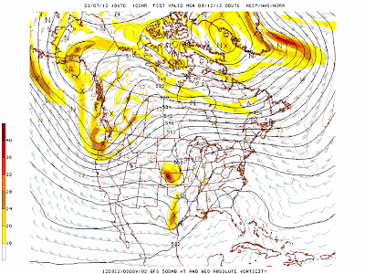
500mb Forecast Sunday evening 3/11/12
However cold air is not likely to affect Star Valley with this pattern as the upper flow remains west to southwest off the Pacific.  This is reflected in the longer range outlook for next week by the Climate Prediction Center.

Temperature Forecast March 13-17 2012


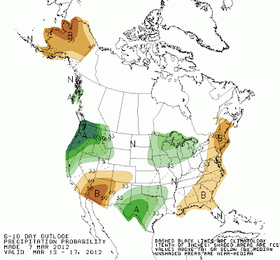
Precipitation Forecast March 13-17 2012

Unseasonably warm weather is expected over most of the U.S. from the Rockies eastward.

The March 2012 Snow/Runoff for Wyoming was recently issued by the National Resources Conservation Service in Casper.  http://www.wcc.nrcs.usda.gov/cgibin/newbor.pl?state=wy&year=2012&month=3&format=html

Much improved conditions were experienced statewide from the February report.  In particular here is the report for the Snake River Basin which includes Star Valley.

The Snake River Basin snow water equivalent (SWE) is 95% of average.  
SWE in the Snake River Basin above Jackson Lake is 101% of average.  
Pacific Creek Basin SWE is 117% of average.  Gros Ventre River Basin 
SWE is 88% of average.  SWE in the Hoback River drainage is 87% of 
average.  SWE in the Greys River drainage is 90% of average.   In 
the Salt River area SWE is 89% of average.  SWE in the Snake River 
Basin above Palisades is 95% of average.  See the  Basin Summary of 
Snow Course Data  at the beginning of this report for a detailed 
listing of snow course information.
 
Precipitation
Precipitation across the basin was about average last month.  
Monthly precipitation for the basin was 98% of average (129% of last 
year).  Last month's percentages range from 72-127% of average for 
the 16 reporting stations.  Water-year-to-date precipitation is 96% 
of average for the Snake River Basin (89% of last year).  Year-to-
date percentages range from 68-116% of average.
 
Reservoir
Current reservoir storage is 122% of average for the 3 storage 
reservoirs in the basin.  Grassy Lake storage is about 103% of 
average (12,300 ac-ft compared to 13,200 last year).  Jackson Lake 
storage is 130% of average (640,000 ac-ft compared to 656,600 ac-ft 
last year).  Palisades Reservoir storage is about 118% of average 
(1,223,500 ac-ft compared to 875,700 ac-ft last year).  Detailed 
reservoir data is shown on the following page and on the reservoir 
storage summary at the beginning of this report.
 
Streamflow
The 50% exceedance forecasts for April through September are below 
average for the basin. The Snake near Moran is 905,000 ac-ft (100% 
of average).  Snake River above reservoir near Alpine is 2,560,000 
ac-ft (94% of average).  The Snake near Irwin is 3,570,000 ac-ft 
(92% of average).  The Snake near Heise is 3,830,000 ac-ft (92% of 
average).  Pacific Creek near Moran is 200,000 ac-ft (112% of 
average).  Buffalo Fork above Lava near Moran is 360,000 ac-ft (105% 
of average).  Gros Ventre River at Kelly is 260,000 ac-ft (107% of 
average).  Greys River above Palisades Reservoir is 355,000 ac-ft 
(90% of average).  Salt River near Etna is 365,000 ac-ft (87% of 
average).


Sunday, March 4, 2012

A Break in the Snow with Hints of Spring

Star Valley Ranch observed 25 consecutive days of a least some snow.  Sunday, March 4 is the first day in almost 4 weeks that snow flakes did not fall out of the skies of Star Valley.  Substantial recovery has occurred in the mountain snow pack since the first of the year. Surveying the SNOTEL sites in the nearby mountain, as of March 4th, all of them are now measuring normal or slightly above normal snow packs.

Temperatures Sunday afternoon were the warmest so far in 2012, with most valley locations in the mid to upper 40s.

The next threat to Star Valley Weather is the cold upper trough located in the Gulf of Alaska Sunday evening

500 mb Analysis Sunday Evening 3/4/12


By midnight Tuesday this system is forecast to strongly develop southeastward leading to a rather deep upper low over the desert southwest.
500 mb forecast midnight Tuesday 3/6/12


While the strongest portion of this system will track west and then south of Star Valley across Nevada and Utah, some snow will return to the area by Tuesday.  Amounts are not expected to be more than a couple inches in the valley.

High pressure and much warmer air will then spread across the western States later in the week leading to the first real signs of Spring as temperatures could warm to near 50 by weeks end.

The surveys are still underway in the wake of the devastating Tornado Outbreak in the central portion of the Nation on Friday.  As of Tuesday morning there have been 144 Tornadoes logged with over 900 total reports of severe weather.


The fatality total is close to 40 making it one of the deadliest early March Outbreaks on record.

Additional information for this event can be found on the Storm Predictions Center website Severe Events page at


http://www.spc.noaa.gov/exper/archive/event.php?date=20120302

Thursday, March 1, 2012

Major Trough Moves East of Star Valley

The cold trough of low pressure that  dominates the western states mid-day Thursday

500 mb Analysis Noon Thursday 3/1/12


shifts east into the central states by late Friday

500 mb forecast midnight Friday 3/2/12
This will finally lead to an ending of virtually weeks of at least some daily snow for Star Valley.  By Sunday, the high pressure ridge will have moved far enough east to essentially end the chances of snow.  Thursday, March 1st was the 23rd consecutive day of at least a trace of snow being observed at Star Valley Ranch.  In that period of time, a total of 45 inches of snow fell, with a current snow cover of around 40 inches.

The strong cold front that passed across the valley Wednesday afternoon resulted in briefly near zero visibilities as a quick two inches of snow fell,  along with strong winds. The web cam, located about 6 miles south of Alpine, provided a rather spectacular view of the snow front's passage.  Here is a short video from that site.


With the cold trough shifting east into the Central States the snow fall in our area will diminish and likely end by later Saturday.  However it will lead to a potentially  serious Severe Thunderstorm and Tornado Outbreak in parts of the Mississippi/Ohio and Tennessee Valleys by Friday afternoon per the latest forecast from the Storm Prediction Center.

All of the ingredients are expected to be available for developing supercell thunderstorms, which could then produce damaging tornadoes.  Those interested in following this threat can refer to the Storm Prediction Centers web site  spc.noaa.gov